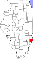
Lawrence County, Illinois
| Lawrence County, Illinois | |
| Map | |
 Location in the state of Illinois |
|
 Illinois's location in the U.S. |
|
| Statistics | |
| Founded | 1821 |
|---|---|
| Seat | Lawrenceville |
| Area - Total - Land - Water |
374 sq mi (969 km²) 372 sq mi (963 km²) 2 sq mi (5 km²), 0.52% |
| Population - (2000) - Density |
15,452 42/sq mi (16/km²) |
| Website: www.lawrencecountyillinois.com | |
Lawrence County is a county located in the U.S. state of Illinois. As of 2000, the population was 15,452. Its county seat is Lawrenceville.[1]
Contents |
History
Lawrence County was formed in 1821 out of Crawford and Edwards Counties. It was named for Captain James Lawrence, killed in action in 1813 while in command of the frigate USS Chesapeake. Mortally wounded, he uttered the famous phrase "Don't give up the ship".
Geography
According to the U.S. Census Bureau, the county has a total area of 374 square miles (968 km²), of which, 372 square miles (963 km²) of it is land and 2 square miles (5 km²) of it (0.52%) is water.
Townships
Allison, Bond, Bridgeport, Christy, Denison, Lawrence, Lukin, Petty, Russell
Adjacent counties
- Crawford County to the north
- Knox County, Indiana to the east
- Wabash County to the south
- Richland County to the west
Townships
Nine townships make up Lawrence County. They are:
- Allison
- Bond
- Bridgeport
- Christy
- Denison
- Lawrence
- Lukin
- Petty
- Russell
Demographics

| Historical populations | |||
|---|---|---|---|
| Census | Pop. | %± | |
| 1900 | 16,523 |
|
|
| 1910 | 22,661 | 37.1% | |
| 1920 | 21,380 | −5.7% | |
| 1930 | 21,885 | 2.4% | |
| 1940 | 21,075 | −3.7% | |
| 1950 | 20,539 | −2.5% | |
| 1960 | 18,540 | −9.7% | |
| 1970 | 17,522 | −5.5% | |
| 1980 | 17,807 | 1.6% | |
| 1990 | 15,972 | −10.3% | |
| 2000 | 15,452 | −3.3% | |
| IL Counties 1900-1990 | |||
As of the census[2] of 2000, there were 15,452 people, 6,309 households, and 4,252 families residing in the county. The population density was 42 people per square mile (16/km²). There were 7,014 housing units at an average density of 19 per square mile (7/km²). The racial makeup of the county was 97.97% White, 0.76% Black or African American, 0.14% Native American, 0.12% Asian, 0.27% from other races, and 0.74% from two or more races. 0.89% of the population were Hispanic or Latino of any race. 27.5% were of American, 21.6% German, 17.4% English and 10.2% Irish ancestry according to Census 2000. 98.5% spoke English and 1.3% Spanish as their first language.
There were 6,309 households out of which 28.70% had children under the age of 18 living with them, 54.90% were married couples living together, 9.00% had a female householder with no husband present, and 32.60% were non-families. 29.20% of all households were made up of individuals and 15.00% had someone living alone who was 65 years of age or older. The average household size was 2.36 and the average family size was 2.89.
In the county the population was spread out with 22.70% under the age of 18, 7.60% from 18 to 24, 26.20% from 25 to 44, 23.40% from 45 to 64, and 20.10% who were 65 years of age or older. The median age was 41 years. For every 100 females there were 91.00 males. For every 100 females age 18 and over, there were 87.80 males.
The median income for a household in the county was $30,361, and the median income for a family was $37,050. Males had a median income of $28,428 versus $18,727 for females. The per capita income for the county was $17,070. About 10.70% of families and 13.70% of the population were below the poverty line, including 21.30% of those under age 18 and 8.50% of those age 65 or over.
Cities and towns
Cities
- Bridgeport
- Lawrenceville
- St. Francisville
- Sumner
Villages
- Birds
- Russellville
Unincorporated towns
- Billet
- Chauncey
- Helena
- Petrolia
- Pinkstaff
- Russelville
- Sand Barrens
- Westport
References
- ↑ "Find a County". National Association of Counties. Retrieved on 2008-01-31.
- ↑ "American FactFinder". United States Census Bureau. Retrieved on 2008-01-31.
External links
- Lawrence County official site
- Lawrence County Fact Sheet, Illinois State Archives
- Blue Star Emergency Medical Services Official Site
|
||||||||||||||||||||
|