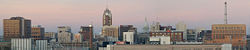
Lansing, Michigan
| City of Lansing | |||
 |
|||
|
|||
 |
|||
| Coordinates: | |||
| Country | United States | ||
|---|---|---|---|
| State | Michigan | ||
| Counties | Ingham, Eaton | ||
| Settled | 1835 | ||
| Incorporation | 1859 | ||
| Government | |||
| - Type | Strong Mayor-Council | ||
| - Mayor | Virg Bernero (D) | ||
| Area | |||
| - City | 35.2 sq mi (91.3 km²) | ||
| - Land | 35.0 sq mi (90.8 km²) | ||
| - Water | 0.20 sq mi (0.50 km²) | ||
| - Urban | 136.8 sq mi (354.4 km²) | ||
| - Metro | 1,714.6 sq mi (4,440.8 km²) | ||
| Elevation | 860 ft (262 m) | ||
| Population (2000) | |||
| - City | 119,128 | ||
| - Density | 3,403.6/sq mi (1,312.3/km²) | ||
| - Urban | 300,032 | ||
| - Metro | 454,044 | ||
| - Demonym | Lansingite | ||
| Time zone | EST (UTC-5) | ||
| - Summer (DST) | EDT (UTC-4) | ||
| ZIP code | 48901-48980 [1] | ||
| Area code(s) | 517 | ||
| FIPS code | 26-46000[1] | ||
| GNIS feature ID | 1625035[2] | ||
| Website: http://www.cityoflansingmi.com | |||
Lansing (pronounced /ˈlænsɪŋ/) is the capital city of the U.S. state of Michigan, and the state's sixth largest city. It is located about 80 miles (125 km) west-northwest of Detroit and is mostly in Ingham County, although small portions of the city extend into Eaton County. As of the 2000 census, it has a population of 119,128, an Urbanized Area (UA) population of 300,032, and, as of July 1, 2007, a Metropolitan Statistical Area (MSA) population of 456,440.[3] The even larger Combined Statistical Area (CSA) population, which includes Shiawassee County, is estimated at 528,193.[4]
The Lansing metropolitan area, colloquially referred to as "Mid-Michigan," is an important center for educational, cultural, governmental, business, and high-tech manufacturing institutions, including three medical schools (two human medicine and one veterinary), two nursing schools, two law schools including the nation's largest law school, a Big Ten Conference university (Michigan State), the state capital, the state Supreme Court and Court of Appeals, a federal court, the Library of Michigan and Historical Center, and headquarters of four national insurance companies.
Lansing is the only U.S. state capital (among the 44 located in counties) that is not also a county seat. The county seat of Ingham County is Mason, but the county maintains some offices in Lansing.
Contents |
History
The area that is now Lansing was originally surveyed in 1825 in what was then dense forest. There would be no roads to this area for decades to come.[5]
In the winter of 1835 and early 1836, two brothers from New York plotted the area now known as REO Town just south of downtown Lansing and named it "Biddle City." All of this land lay in a floodplain and was underwater during the majority of the year. Regardless, the brothers went back to New York, specifically Lansing, New York, to sell plots for the town that did not exist. They told the residents of Lansing, New York that this new "city" had an area of 65 blocks, contained a church and also a public and academic square. A group of 16 men bought plots in the nonexistent city and upon reaching the area later that year found they had been scammed. Many in the group too disappointed to stay ended up settling around what is now Metropolitan Lansing. Those who stayed quickly renamed the area "Lansing Township" in honor of their home village in New York.[5]
The sleepy settlement of fewer than 20 people would remain dormant until the winter of 1847 when the state constitution required that the capital be moved from Detroit to a more centralized and safer location in the interior of the state since many were concerned about Detroit's close proximity to British-controlled Canada, which had captured Detroit in the War of 1812. The United States had recaptured the city in 1813, but these events led to the dire need to have the center of government relocated away from hostile British territory. In addition, there was also concern with Detroit's strong influence over Michigan politics, being the largest city in the state as well as the capital city.[5]
During the multi-day session to determine a new location for the state capital, many cities, including Ann Arbor, Marshall, and Jackson, lobbied hard to win this designation.[6] Unable to publicly reach a consensus due to constant political wrangling, the Michigan House of Representatives privately chose the Township of Lansing out of frustration. When announced, many present openly laughed that such an insignificant settlement was now the capital city of Michigan. Two months later, the governor William L. Greenly signed into law the act of the legislature officially making Lansing Township the state capital.[5]
With the announcement that Lansing Township had been made the capital, the small village quickly transformed into the seat of state government. The legislature gave the settlement the temporary name of the "Town of Michigan." In April 1848, the legislature then gave the settlement the name of "Lansing." Within months after it became the capital city, individual settlements began to develop along three key points along the Grand River in the township.[5]
"Lower Village/Town," where present-day Old Town stands, was the oldest of the three villages. It was home to the first house built in Lansing in 1843 by pioneer James Seymour and his family. Lower Town began to develop in 1847 with the completion of the Franklin Avenue (now Grand River Avenue) covered bridge over the Grand River.[7]

"Upper Village/Town," where present-day REO Town stands at the confluence of the Grand River and the Red Cedar River. It began to take off in 1847 when the Main Street Bridge was constructed over the Grand River. This village's focal point was the Benton House, a 4-story hotel which opened in 1848. It was the first brick building in Lansing and was later razed in 1900.[7]
"Middle Village/Town," where downtown Lansing now stands, was the last of the three villages to develop in 1848 with the completion of the Michigan Avenue bridge across the Grand River and the completion of the temporary capitol building which sat where Cooley Law School stands today on Capitol Avenue in between Allegan and Washtenaw Streets, and finally the relocation of the post office to the village in 1851. This area would grow to become larger than the other two villages up and down river. For a brief time the combined villages were referred to as "Michigan" but was officially named Lansing in 1848.[7]
In 1859, the settlement having grown to nearly 3,000 and encompassing about 7 square miles (18 km2) in area was incorporated as a city. The boundaries of the original city were Douglas Avenue to the north, Wood and Regent Streets to the east, Mount Hope Avenue to the south, and Jenison Avenue to the west. These boundaries would remain unchanged until 1916. Lansing began to grow steadily over the next two decades with the completion of the railroads through the city, a plank road, and the completion of the current capitol building in 1878.
Most of what is known as Lansing today is the direct result of the city becoming an industrial powerhouse which began with the founding of Olds Motor Vehicle Company in August 1897. The company went through many changes, including a buyout, between its founding to 1905 when founder Ransom E. Olds started his new company REO Motor Car Company, which would last in Lansing for another 70 years. Olds would be joined by the less successful Clarkmobile around 1903.[8] Over the next decades, the city would see itself transformed into a major American industrial center for the manufacturing of automobiles and automobile parts among other industries. The city continued to grow in area too. By 1956, the city had grown to 15 square miles (39 km2), and doubled in size over the next decade to its current size of roughly 33 square miles (85 km2).[9]
Today, the city's economy is now diversified among government service, healthcare, manufacturing, insurance, banking, and education.
Timeline

| Historical populations | |||
|---|---|---|---|
| Census | Pop. | %± | |
| 1850 | 1,299 |
|
|
| 1860 | 3,074 | 136.6% | |
| 1870 | 5,241 | 70.5% | |
| 1880 | 8,319 | 58.7% | |
| 1890 | 13,102 | 57.5% | |
| 1900 | 16,485 | 25.8% | |
| 1910 | 31,229 | 89.4% | |
| 1920 | 57,327 | 83.6% | |
| 1930 | 78,397 | 36.8% | |
| 1940 | 78,753 | 0.5% | |
| 1950 | 92,129 | 17% | |
| 1960 | 107,807 | 17% | |
| 1970 | 131,403 | 21.9% | |
| 1980 | 130,414 | −0.8% | |
| 1990 | 127,321 | −2.4% | |
| 2000 | 119,128 | −6.4% | |
| Est. 2007 | 114,947 | −3.5% | |

- 1825 – Lansing Township surveyed.
- 1836 – A pair of New York speculators plot and market a non-existent city known as "Biddle City." The New Yorkers that bought into the idea arrive in Lansing to discover that the plots they had bought are located in a marsh, and are underwater. Some of the pioneers stay, but develop a village in what is now Old Town Lansing a mile north of the non-existent "Biddle City."
- 1847 – The state capital moved from Detroit to Lansing Township.
- 1855 – Michigan State University is founded as the Agricultural College of the State of Michigan.
- 1859 – The city of Lansing officially incorporated with about 3,000 citizens inside of 7.5 square miles (19 km2).
- 1879 – New State Capitol dedicated. The structure cost $1,510,130.
- 1881 – Michigan Millers Insurance Company founded.
- 1897 – Ransom E. Olds drives his first car down a Lansing street. Later that year he founded the Olds Motor Vehicle Company, which became the Oldsmobile division of General Motors in 1908, and he was also the founder of the REO Motor Car Company in 1904, both headquartered in Lansing.
- 1904 – The "most extensive flood in 135 years of local history" causes the Grand River to overflow its banks in March 24–27, leading to major damage and one death.[10] Bridges at Logan Street, Kalamazoo Street, Cedar Street and Mt. Hope Road are all washed away. The Kalamazoo St. bridge lodges against the Michigan Avenue bridge; it is later salvaged and re-erected at Kalamazoo Street.[11]
- 1910 – The population of the city nearly doubles from the 1900 census to 31,229.
- 1912 – The Accident Fund Insurance Company of America founded.
- 1916 – Auto-Owners Insurance Company founded.
- 1929 – The Lansing Symphony Orchestra founded.
- 1940 – Lansing's population stagnates, only rising by 356 over the decade to 78,753.
- 1954 – Frandor Mall opens – first in the area, and second in the state.
- 1956 – The city reaches 15 square miles (39 km2) in size.
- 1957 – Lansing Community College founded.
- 1960 – The city's population finally breaks the 100,000 mark at 107,807.
- 1961 – Jackson National Life Insurance Company founded.
- 1965 – The city reaches 33.3 square miles (86.2 km2) in size.
- 1970 – Lansing reaches its peak population of 131,546.
- 1972 – The Thomas M. Cooley Law School founded.
- 1980 – Lansing's population declines for the first time losing 989 to hit 130,414.
- 1989 – The Library of Michigan and Historical Center near the Capitol Complex dedicated.
- 1992 – The Michigan State Capitol completes an extensive renovation to restore it to its original grandeur.
- 1998 – Mayor David Hollister signs a 425 Agreement with Alaiedon Township in September to facilitate the development of the headquarters of Jackson National Life Insurance Company.
- 1999 – Mayor David Hollister signs a 425 Agreement with Meridian Township in November to facilitate the development of the Governor's Collection/College Fields upscale housing development and golf course.
- 2000 – Lansing's population experiences its greatest drop in its history, falling over 6% over the preceding decade to 119,128.
- 2001 – GM opens new assembly plant, Lansing Grand River Assembly. Builds the Cadillac CTS, STS, SRX and V-Series. The architecture of the assembly plant resembles a high-tech research facility instead of a traditional factory.
- 2002 – The Hall of Justice (Michigan Supreme Court building) at the West-end of the Capitol Complex is dedicated.
- 2004 – Last Oldsmobile rolls off the assembly line at Lansing Car Assembly on April 29. This same year the Thomas M. Cooley Law School becomes the largest law school in the nation.
- 2005 – Mayor Tony Benavides signs a series of three 425 Agreements with Delta Township and General Motors facilitating the development General Motors' Lansing Delta Township Assembly Plant.
- 2006 – GM opens state of the art facility in nearby Delta Charter Township. As with the 2001 assembly plant built in Lansing, the Delta plant resembles a high-tech research facility and not a traditional factory.
- 2008 - Accident Fund announces the rennovation of the Ottawa Street Power Plant and addition of modern buildings connected by an atrium for their new headquarters.
Geography and climate
Lansing is the centerpiece of a region of Michigan known as Mid-Michigan or Central Michigan.
According to the United States Census Bureau, the city has a total area of 35.2 square miles (91 km2), of which 35.0 square miles (91 km2) of it is land and 0.2 square miles (0.52 km2) (0.57%) of it is water. This figure includes two 425 Agreements with Alaiedon Township and Meridian Township, but not the four 425 Agreements with Delta Township since 2000.
Under Michigan law, 425 Agreements are only temporary land sharing agreements, and do not count as official annexations. The Census Bureau, however, for statistical purposes, does count these as annexations. Not counting the temporary 425 Agreements, Lansing administers 34.1 square miles (88 km2) total.
Lansing is located in the south central part of the lower peninsula where the Grand River meets the Red Cedar River. The city occupies most of what had formerly been part of Lansing Charter Township. It has also annexed adjacent tracts of land in Delta Charter Township and Windsor Township in Eaton County to the west and Delhi Charter Township in Ingham County to the south. The city also controls three non-contiguous tracts of land through 425 Agreements (conditional land transfer agreements) with Meridian Charter Township, Delta Charter Township, and Alaiedon Township in Ingham County to the southeast.

Lansing elevation ranges between 890 feet (271 m) above sea level on the far south side of Lansing along Northrup Street near the Cedar Street intersection, to 833 feet (254 m) to 805.5 feet (246 m) above sea level along the Grand River because of the two dams along the river.
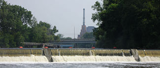
The Grand River, the largest river in Michigan, flows through downtown Lansing; and the Red Cedar River, a tributary of the Grand River, flows through the campus at Michigan State University. There are two lakes in the area, Park Lake and Lake Lansing, both northeast of the city. Lake Lansing is approximately 500 acres (2.0 km2) in size and is a summer favorite for swimmers, boaters, and fishermen. Michigan State University Sailing Club and the Lansing Sailing Club are located on Lake Lansing, where sailing regattas are hosted throughout the summer.
The city of Lansing operates a total of 3.6 square miles (9.3 km2) of parkland, of which 2.8 square miles (7.3 km2) is parkland, 0.5 square miles (1.3 km2) are golflands, and 0.3 square miles (0.78 km2) are cemetery lands. This figure includes the Waverly Hills Golf Course and adjacent Michigan Avenue Park, which are part of Lansing Township, but operated by the City of Lansing. The figure, however, does not include the [Ingham County parklands within the borders of Lansing.[12]
| Monthly Normal and Record High and Low Temperatures | ||||||||||||
| Month | Jan | Feb | Mar | Apr | May | Jun | Jul | Aug | Sep | Oct | Nov | Dec |
|---|---|---|---|---|---|---|---|---|---|---|---|---|
| Rec High °F (°C) | 66 (18.8) | 69 (20.5) | 79 (26.1) | 86 (30) | 94 (34.4) | 99 (37.2) | 100 (37.7) | 100 (37.7) | 97 (36.1) | 89 (31.6) | 77 (25) | 69 (20.5) |
| Norm High °F (°C) | 29.4 (-1.4) | 32.6 (0.3) | 43.5 (6.4) | 56.6 (13.6) | 69.4 (20.7) | 78.1 (25.6) | 82.1 (27.8) | 79.7 (26.5) | 72 (22.2) | 59.8 (15.4) | 46 (7.7) | 34.1 (1.2) |
| Norm Low °F (°C) | 13.9 (-10.05) | 15.4 (-9.2) | 24.3 (-4.3) | 34.5 (1.4) | 44.8 (7.1) | 54.3 (12.4) | 58.4 (14.6) | 57 (13.4) | 48.9 (9.4) | 38.6 (3.6) | 30.1 (-1.05) | 19.7 (-6.8) |
| Rec Low °F (°C) | -29 (-33.8) | -25 (-31.6) | -15 (-26.1) | -2 (-18.8) | 19 (-7.2) | 30 (-1.1) | 37 (2.7) | 35 (1.6) | 22 (-5.5) | 15 (-9.4) | 4 (-15.5) | -18 (-27.7) |
| Precip in (mm) | 1.61 (40.9) | 1.45 (36.8) | 2.33 (59.2) | 3.09 (78.5) | 2.71 (68.8) | 3.6 (91.4) | 2.68 (67.1) | 3.46 (87.9) | 3.48 (88.4) | 2.29 (58.2) | 2.66 (67.6) | 2.17 (55.1) |
| Source: USTravelWeather.com [2] | ||||||||||||
Neighborhoods

The city's downtown is dominated by state government buildings, especially the State Capitol; but downtown has also experienced recent growth in new restaurants, retail stores and residential developments. Downtown Lansing has a historic city market that is one of the oldest continuously operating farmers' markets in the United States. Upriver and north of downtown is historic Old Town Lansing with many architecturally significant buildings dating to the mid-1800s. Directly south of downtown on the other side of I-496 along Washington Avenue lies "REO Town," the birthplace of the automobile in the United States, is where Ransom Eli Olds built factories along Washington Avenue. Ransom Eli Olds' home, which once overlooked the factories along Washington Avenue, was displaced by I-496.
Lansing is generally divided into four sections: Eastside, Westside, Northwestside, and the Southside. Each section contains a diverse array of neighborhoods. The Eastside, located east of the Grand River and north of the Red Cedar River, is the most ethnically diverse side of Lansing, with foreign-born citizens making up more of its population than any other side in the city. The Eastside's commercial districts are located mainly along Michigan Avenue, and to a lesser extent along Kalamazoo Street. It is anchored by Frandor Shopping Center on the very eastern edge of the eastside.
The Westside, roughly located north, west, and south of the Grand River as it curves through the city, is sometimes regarded the city's most socio-economically diverse section. This side also contains Lansing's downtown area, though this neighborhood is often included as an area all its own. Outside downtown, this side is largely a collection of residential neighborhoods and is served by only one other commercial area along Saginaw Street. However, it also includes a small part of the Old Town Commercial Association.
The Northwestside, generally located north of the Grand River, with the city limits defining its north and western borders, is physically the smallest side of the city. This part of the city includes suburban areas and some more rural areas. North of Grand River Avenue, the main street of the side, lie warehouses and light industrial areas served by a major rail line that runs through Lansing. The most notable landmark of this side is Lansing's airport: Lansing Capital City Airport.
The Southside, usually described as the neighborhoods located south of the Grand and Red Cedar rivers and the I-496 freeway, is physically the largest and most populous side of the city, and contains some of the city's most healthy neighborhoods. The area is largely suburban in nature (south of Mount Hope Road near the northern edge), and is served by numerous commercial strips along Cedar Street, Martin Luther King, Jr. Boulevard, Pennsylvania Avenue, and Waverly Road, which run north/south. The large Edgewood District is located in the southernmost part of the Southside and is sometimes referred to as South Lansing. Though it is the largest area of the city by both physical size and population, it has often been regarded by Southside citizens as Lansing's most overlooked and forgotten area, as most of Lansing's attention in recent decades has been put into the revitalization of the city's historic core located mostly on small parts of both the East and Westsides.
Demographics

As of the census[1] of 2000, there were 119,128 people, 49,505 households, and 28,366 families residing in the city. The population density was 3,399.0 per square mile (1,312.3/km²). There were 53,159 housing units at an average density of 1,516.8/sq mi (585.6/km²). The racial makeup of the city was 65.28% White (61.4% non-Hispanic White), 21.91% African American, 0.80% Native American, 2.83% Asian, 0.05% Pacific Islander, 4.54% from other races, and 4.60% from two or more races. Hispanic or Latino of any race were 10.0% of the population. The city's foreign-born population stood at 5.9%.
As of 2000, the city's population rose by 32,293 (27%) to 151,421 during the day due to the influx of workers.[13]
There were 49,505 households out of which 30.0% had children under the age of 18 living with them, 35.8% were married couples living together, 17.0% had a female householder with no husband present, and 42.7% were non-families. 33.2% of all households were made up of individuals and 8.1% had someone living alone who was 65 years of age or older. The average household size was 2.39 and the average family size was 3.08.
In the city the population was spread out with 26.8% under the age of 18, 11.4% from 18 to 24, 32.7% from 25 to 44, 19.3% from 45 to 64, and 9.7% who were 65 years of age or older. The median age was 31 years. For every 100 females there were 92.3 males. For every 100 females age 18 and over, there were 87.9 males.
The median income for a household in the city was $34,833, and the median income for a family was $41,283. Males had a median income of $32,648 versus $27,051 for females. The per capita income for the city was $17,924. About 13.2% of families and 16.9% of the population were below the poverty line, including 23.2% of those under age 18 and 9.0% of those age 65 or over.
Government
Municipal government
Lansing is administered under a mayor-council government, more specifically a "strong mayor" setup in which the mayor holds most of the city's administrative powers, such as appointment of department heads and drafting and administering a city budget, though the council must approve his/her actions. The mayor is elected at-large every four years. Lansing is different from most U.S. cities in that its eight-member city council includes four members each elected from one of four wards, as well as four "at-large" members elected citywide. The reasoning behind this system is that while each ward of the city gets its own representation, the at-large councilmembers serve as a voice for often- underrepresented neighborhoods in those wards.

The current mayor is Virgil Bernero, who took office on January 1, 2006. The city council members as of January 3, 2008 are: Eric Hewitt (1st Ward), Sandy Allen (2nd Ward), A'Lynne Robinson (3rd Ward), Tim Kaltenbach (4th Ward), Kathie Dunbar (at-large), Brian Jeffries (at-large and Council President), Derrick Quinney (at-large and Council Vice President) and Carol Wood (at-large).
- List of Mayors of Lansing, Michigan
State and federal representation
Lansing currently lies mostly within the boundaries of Michigan's 8th congressional district, which has been represented by Republican congressman Mike J. Rogers since 2001. The small portion of the city that extends into Eaton County is located in Michigan's 7th congressional district, which has been represented by Republican congressman Tim Walberg since 2006.
At the state level, Lansing is located in the 23rd district of the Michigan Senate, which has been represented by Democratic state senator Gretchen Whitmer since January 1, 2007. The small portion of the city that extends into Eaton County is located in the 24th district of the Michigan Senate, which is currently represented by Republican state senator Patricia L. Birkholz. The city lies in the 67th, 68th, 69th, and 71st districts of the Michigan State House of Representatives, represented by Democratic state representative Barb Byrum, Democratic state representative Joan Bauer, Democratic state representative Mark Meadows, and Republican state representative Rick Jones, respectively.
Despite Lansing not being a designated county seat, many county offices and courts are still located within downtown Lansing, including the county circuit court.
Economy
The Lansing metropolitan area's major industries are government, education, insurance, healthcare, and automobile manufacturing. Being the state capital, many state government workers reside in the area.
Michigan State University, Thomas M. Cooley Law School, and Lansing Community College are significant employers in the region.

General Motors has offices and a hi-tech manufacturing facility in Lansing and several manufacturing facilities immediately outside the city, as well, in nearby Lansing and Delta townships. The Lansing area is headquarters to four major national insurance companies: Auto-Owners Insurance Company, Jackson National Life, the Accident Fund, and Michigan Millers Insurance Company. The Lansing area is also home to rapidly growing financial companies such as Siena Capital Management and Capitol Bancorp Limited. Elderly Instruments, an internationally recognized music retailer, is located in Lansing.
The recent decline of the auto industry in the region has increased the region's awareness of the importance of a strategy to foster the high-technology sector.
- An initiative called Prima Civitas, created by Michigan State University, in cooperation with the cities of Lansing and East Lansing, under the direction of former Lansing mayor David Hollister, is spearheading focused economic development in the technology sector in the region.
- Early availability of high-speed Internet in 1996, as well as the MSU, Cooley Law School, and LCC student population, fostered an intellectual environment for information technology companies to incubate.
Lansing has a number of technology companies in the fields of information technology and Biotechnology.
- Neogen Corporation is an international food and animal safety company headquartered in Lansing. Neogen develops and manufactures among other things, diagnostic kits, equine vaccines and culture media. [3]
- Emergent BioSolutions is an international biopharmaceutical company that maintains significant operations in Lansing. Emergent BioSolutions is developing an array of biodefense and commercial products and currently manufactures the only FDA approved anthrax vaccine at its Lansing operations. [4]
- TechSmith Corporation is located just outside Lansing and is the world’s leading provider of screen capture and recording software for individual and professional use. [5]
- Liquid Web, Inc. is a web hosting company located in neighboring Delta Township, and operates two datacenters there.[6]
- Niowave is a high-tech company in Lansing that makes parts for superconducting particle accelerators.
- ACD.net is an independent company in Lansing that provides high-speed Internet service, Web hosting, telephone service and data storage to more than 20,000 customers across Michigan.
"Cool City" and downtown redevelopment
Several urban renewal projects by private developers are adding higher end apartments and condominiums to the Lansing market. The Arbaugh, a former department store across from Cooley Law School was converted into apartments in 2005. Motor Wheel Lofts [7], an industrial site will be converted into loft-style living spaces in mid-2006. A combination retail and residential complex to the south of Oldsmobile Park baseball stadium called "The Stadium District" [8], was completed in 2007. In May 2006, the historically significant Mutual Building located on Capitol Avenue was purchased by The Christman Company to be renovated back to its original grandeur and used as the company's headquarters. Additional downtown developments include the renovation of the historic Hollister Building, and the expansion of the former Abrams Aerial Building. As of August 2008, an 18-story condominium high-rise called Capitol Club Tower is in the design phase with the adjacent parking structure already having been approved by city council and purchased by the developer. The city market, in existence since 1909, was approved to be sold for a multi-building mixed use development called MarketPlace that will be built after a new city market is built by 2009, right next to the current market on the adjacent riverfront. The MarketPlace project is being developed along with BallPark North, another mixed-use development that will be immediately north of Oldsmobile Stadium. The new city market will be across the river from where the Accident Fund insurance company is rennovating the former (art deco) Ottawa Street Powerplant into their new headquarters as well as the addition of modern buildings to the north that will be connected by an atrium.
List of largest metro Lansing employers – 2005
Source: Lansing Chamber of Commerce - Lansing Region's Largest Employers - 2005[14]
| Company/Organization | Sector | Local Full-time Employment |
|---|---|---|
| State of Michigan | Government | 14,355 |
| Michigan State University | Higher Education | 10,500 |
| General Motors Corporation | Automobile Manufacturing | 6,300 |
| Sparrow Health System | Healthcare | 6,000 |
| Lansing Community College | Higher Education | 3,180 |
| Ingham Regional Medical Center | Healthcare | 2,500 |
| Lansing Public School District | Primary Education | 2,106 |
| Meijer | Warehousing, Retailer, Grocer | 2,000 |
| Auto-Owners Insurance | Insurance | 1,500 |
| Peckham, Inc. | Manufacturing | 1,400 |
| Jackson National Life | Insurance | 1,393 |
| Ingham County | Government | 1,258 |
| City of Lansing | Government | 1,240 |
| United States Postal Service | Government | 1,200 |
| Wal-Mart | Retailer | 1,185 |
| Dart Container | Container Manufacturer | 1,144 |
Education
Michigan State University, a member of the Big Ten Conference, is known as "the pioneer land grant college," located in neighboring East Lansing. MSU has the largest land campus in the United States and is home to several nationally and internationally recognized academic and research oriented programs. Michigan State offers over 200 programs of study and is home to fourteen different degree-granting schools and colleges including three medical schools, a law school, and numerous PhD programs. It is the only university in the nation with three medical schools. MSU is consistently one of the top three programs in the United States for study abroad programs. The MSU College of Education is also consistently rated as the top education program in the nation. Michigan State University is the oldest agricultural college in the United States. The MSU School of Criminal Justice is the oldest continuous degree granting criminal justice program in the nation.
The Thomas M. Cooley Law School is the largest law school in the nation and is located in downtown Lansing. Cooley is fully accredited by the American Bar Association. A majority of Cooley students are from out-of-state.
Lansing Community College offers more than 500 areas of study to over 18,000 students at its main facilities in Lansing, and another 5,000 students at twenty-nine extension centers and a site in Otsu, Japan. LCC's new, state-of-the-art University Center enables students to take courses with the goal of eventually earning an undergraduate or graduate degree from other Michigan institutions. The University Center stands on the former site of "Old Central", Lansing's first public high school, which was established in 1875 as Lansing High School. (In the 1920s it was renamed as Central High School, and in 1957 became the first building on the LCC campus.)[15]
Other institutions of higher education include Western Michigan University (branch campus in Delta Township), Davenport University in Downtown Lansing, Central Michigan University (branch campus), and Great Lakes Christian College.

Public and private primary schools
- Lansing School District
- Lansing Public Schools: (Lansing Everett, JW Sexton High School, and Lansing Eastern)
- Lansing Christian Schools
- Lansing Catholic Central
- Waverly School District
- Mid-Michigan Public School Academy
- El-Hajj Malik Shabazz Academy (named after Malcolm X)
- Gada Masif Johnson School for the Arts
- Our Savior Lutheran School
Culture
Parades
- The Capital City African American Cultural Association hosts an African American Parade and Heritage Festival every year for almost a decade. The chair of the CCAACA is the Rev. Dr. Michael C. Murphy, who is pastor of St. Stephen's Community Church, a former State Representative and a long-time community leader. The parade highlights African American culture, its influence in Michigan, and recognizes prominent African American individuals in the community and their contributions to Lansing as the grand marshal of each parade. The festival immediately following the parade consists of live entertainment, "soul food" and lots of fun for adults and children. It is held every year on the first Saturday in August and begins at 11:00 a.m. in downtown Lansing, Michigan. The festival is held at Ferris Park in downtown Lansing. In 2009 they will celebrate 10 years.
Music
- The Lansing Symphony Orchestra has been entertaining generations of Lansing area residents since 1929. The current music director is Timothy Muffett.
- The Lansing JazzFest and the Old Town BluesFest host leading musicians, and are two of the larger music festivals held each year in the state.
- It was announced in May 2007 that the city would host a Thursday night, summertime blues concerts along Washington Square in downtown Lansing named "Blues on the Square" that will feature national acts.[9]
- The Common Ground Festival is a musical event held over a week every July at the Adado Riverfront Park in downtown Lansing. It began in 2000 and replaced the Michigan Festival that was held in nearby East Lansing. It has wide range of musical acts. In 2008, acts included Staind, Drowning Pool, Sammy Hagar, The Hard Lessons, Snoop Dogg, REO Speedwagon, Kellie Pickler, Seether [10] and Trace Adkins.
Theatre
- The Riverwalk Theatre (formerly the Okemos Barn Theatre), the Lansing Civic Players, and the BoarsHead Theater are all located in downtown.
- Peppermint Creek Theatre Company is a well established "new" award winning theater company.
- The Greater Lansing Ballet Company is an award-winning ballet and dance company.
- The Creole Gallery brings in various musicians and hosts the Icarus Falling Theater group.
Museums
Lansing is home to a number of small, specialized museums such as:
- The Impression 5 Science Center, a children's museum located in a historic wagon works factory on the Grand River.
- The The Museum of Surveying, the only museum in North America solely dedicated to surveying and mapping. It is located in a former steam plant constructed in 1923.
- The R.E. Olds Transportation Museum, a museum dedicated to the education of Lansing's role in the development of transportation, particularly the automobile.
- The The Michigan Women's Historical Center & Hall of Fame, a museum dedicated to the historical accomplishments and achievements of Michigan women. The house is located directly south of downtown in the 1903-built Cooley-Haze House. The museum is surrounded by Cooley Gardens.
- The Turner-Dodge House & Heritage Center, a museum dedicated to Lansing's early pioneers. The museum sits in the Classical Revival-styled Turner-Dodge Mansion, built in 1858 for James and Marion Turner, and later by their daughter and her husband. It is on the National Register of Historic Places.
Farmers markets
Lansing has several Farmer Markets throughout the City in the summer months. These markets include the Allen Street Farmer's Market [11] on the City's East Side, the Old Town Farmer's Market, and the year round Lansing City Market [12] located near downtown.
Potter Park Zoo
The historic Potter Park Zoo, located along the Red Cedar River in Lansing, has more than 400 animals and numerous programs and events for children and families.
Libraries
The Library of Michigan and Historical Center is a highly regarded state library and research center. The library is one of the top five genealogical research facilities in the United States. The Capital Area District Library has three branches in the city: The Main library downtown, the Foster Library on the east side, and the South Lansing Library on the south side.
Other area destinations
The Wharton Center for Performing Arts, the Kresge Art Museum, the MSU Museum, and the Abrams Planetarium are highly acclaimed cultural destinations located on the campus of Michigan State University in East Lansing.
Media
Newspapers
Television
- WLNS 6 (CBS)(Cable 9)
- WILX 10 (NBC)(Cable 4)
- WHTV 18 (My Network TV)(Cable 8)
- WBL-TV 30 (CW) (Cable 5 only)
- WKAR 23 (PBS)(Cable 13)
- WSYM 47 (FOX)(Cable 7)
- WLAJ 53 (ABC)(Cable 3)
The NBC affiliate maintains the FOX affiliate's News programming. Both affiliates broadcast their newscasts at the News 10 studios in Lansing. Often the same reporters are used on both broadcasts.
Radio
Lansing's radio dial has quite a few stations. Note: If the station has no city listed before the format, it is licensed to Lansing.
- 87.7 WLNS – (audio of CBS Affiliate channel 6)
- 88.1 WLGH – (Leroy Township, contemporary Christian) "Smile FM"
- 88.5 WJOM – (Eagle, contemporary Christian) "Smile FM"
- 88.9 WDBM – (East Lansing, college/Michigan State University) "The Impact"
- 89.7 WLNZ – (public radio/Lansing Community College)
- 90.5 WKAR – (East Lansing, public radio/Michigan State University)
- Note: WKAR runs with 86,000 watts
- 91.3 WOES – (Ovid, polka/Ovid-Elsie High School)
- 92.1 WQTX – (St. Johns, oldies)
- 92.9 WJZL – (Grand Ledge, smooth jazz)
- 93.7 WBCT-FM – (Grand Rapids, country) "B93"
- Note: WBCT runs with 320,000 watts
- 94.1 WVIC – (Jackson, soft rock)
- 94.9 WMMQ – (East Lansing, classic rock)
- 96.5 WQHH – (DeWitt, urban) "Power 96.5"
- 97.5 WJIM – (CHR)
- 99.1 WFMK – (East Lansing, adult contemporary)
- 100.7 WITL-FM – (country) "Whittle"
- 101.7 WHZZ – (adult hits) "Mike-FM"
- 105.7 WOOD – (Grand Rapids, adult contemporary) "Star 105.7"
- 106.1 WJXQ – (Charlotte, active rock) "Q106"
- 107.3 WKLQ – (Greenville/Grand Rapids, rock)
- 730 AM WVFN – (East Lansing, sports talk) "The Game"
- 870 AM WKAR – (East Lansing, NPR news/talk)
- 1110 AM WUNN – (Mason, religious/southern gospel)
- 1180 AM WXLA – (Dimondale, (adult standards) "Timeless Classics 1180"
- 1240 AM WJIM – (news/talk) "Lansing's Big Talker"
- 1320 AM WILS – (news/talk) "More Compelling Talk"
- 1390 AM WLCM – (Charlotte, religious)
- 1580 AM WWSJ – (St. Johns, urban contemporary gospel) "Joy 1580"
- 162.400 WXK81 – NOAA Weather Radio (Onondaga, weather)
Sports
The Lansing Lugnuts are a Class A Midwest League, Minor League Baseball team, currently affiliated with the Toronto Blue Jays. The Lugnuts are one of the most popular franchises in Minor League Baseball, drawing 538,325 fans during the 1996 season , and in the process outdrawing many larger teams. Their logo is one of the most popular in the minors . The team plays its home games at Oldsmobile Park, which was built at a cost of $12.7 million and opened in 1996 in downtown Lansing. It was partially renovated in 2006. Oldsmobile Park has a seating capacity of 11,215 fans, and was built to accommodate additional expansion. The team has won two Midwest League championships, their first in 1997 and their second in 2003.
The Lansing Capitals began play in the International Basketball League in 2006.
Michigan State University sponsors both men's and women's sports, usually competing as a member of the Big Ten Conference. The Spartans have won National Titles in Men's Basketball, Football, Men's Boxing, Men's Cross Country, Men's Gymnastics, Men's Ice Hockey, Men's Soccer, and Men's Wrestling.
Lansing Community College also sponsors many sports, competing as members of the Michigan Community College Athletic Association. The Stars have won NJCAA titles in the following sports: Women's Softball, Men's Basketball, Women's Basketball, Men's Cross Country, Women's Cross Country, Women's Marathon and Men's Marathon.
The Lansing area is also known for its many golf courses, with two courses owned by Michigan State University, four municipal courses, and many additional public and private courses in the area. Walnut Hills Country Club in nearby East Lansing formerly hosted the LPGA's Oldsmobile Classic from 1992–2000. The Michigan PGA recently relocated from the Detroit area to Bath, Michigan, which is on the northern edge of Lansing.
In the 1980s and 1990s Lansing was a major player in semi-pro football. The Lansing Crusaders won MFL/MCFL championships in 1982, 1983, 1985, 1987, 1989, and 1990. The team finished second in 1984, 1986, and 1991.
Other past sports teams include:
- Lansing – Michigan State League (baseball) – 1889 to 1890
- Lansing Senators – Michigan State League (baseball) – 1895 and 1902
- Southern Michigan League – 1907 to 1914
- Central League – 1921 to 1922
- renamed the Lansing Lancers – Michigan State League – 1940
- and then back as the Lansing Senators – Michigan State League – 1941
- Lansing Capitals – North American Basketball League – 1966-67 to 1967-68
- Lansing Lancers – International Hockey League – 1974 to 1975
- Capital City Cardinals – Michigan Charity Football League – 1980
- Lansing Crusaders – Michigan Charity Football League – 1980 to 1988
- Michigan Football League – 1989 to 1994
- Capital City Cowboys – Michigan Football League – 1992
- Lansing Ice Nuts – International Independent Hockey League – 2003 to 2004
Transportation
Airports
- Scheduled commercial airline service is offered from Capital Region International Airport (formerly known as Capital City Airport).[16]
- Portions of Central Michigan are near Midland and Flint. Scheduled airline service is also available from MBS International Airport[17] near Midland, Michigan and Flint Bishop International Airport.[18]
- Other portions are proximate to Gerald R. Ford International Airport, which is east of Grand Rapids, Michigan.[19]
- Michigan Flyer provides bus service between Lansing and Detroit Metro Airport eight times daily.
Major highways
Interstate highways
 I-69 runs from Indianapolis north to Lansing and east to Port Huron, connecting to Canada.
 I-96 runs from Muskegon, past Grand Rapids and Lansing to Detroit.
 I-496, the Ransom E. Olds Freeway, loops through downtown Lansing, connecting with I-96 on either end.
 I-69 Business Loop or BL I-69 is a loop route running through Lansing and East Lansing.
 I-96 Business Loop or BL I-96 is a loop route running through Lansing.
 Capitol Loop a loop route off I-496 serving the state capitol and other downtown facilities.
US highways
 US 127 is a north-south highway passing between the city and neighboring East Lansing, continuing northerly toward Clare and Grayling and southerly toward Jackson, Michigan and into Ohio.
Michigan state trunklines
 M-43 (Saginaw Avenue)
 M-99 (Martin Luther King Jr. Blvd.).
Railways
- Main article: Michigan Services
- Amtrak provides intercity passenger rail service at a stop in nearby East Lansing, on the Blue Water line from Chicago to Port Huron.
- Three freight railroads serve Lansing including Canadian National Railways (CN), CSX Transportation (CSXT), and Norfolk Southern Railway (NS).
Public transportation
- Capital Area Transportation Authority (CATA) provides public transit bus service to the Lansing-East Lansing Metropolitan area, and boasts the second highest ridership in the state of Michigan.
- Greyhound Lines provides inter-city bus service. CATA and Greyhound are both located in the CATA Transportation Center (CTC) in downtown Lansing.
- Also, Lansing has several taxicab companies serving the area, including Spartan-Yellow Cab, Big Daddy Taxi, Jb's Country Club Transportation, S-cabs Taxi Service and L-town cab.
Bicycling
- The eight-mile (13-km), non-motorized Lansing River Trail runs along the Grand River and the Red Cedar River, running as far east as Michigan State University, and passes Potter Park Zoo, the Capitol Loop, and several other destinations of interest, and as far west as Moores Park.
Utilities
- Water supply, Power and Steam are municipally-owned utilities which are provided by Lansing Board of Water & Light. [16]
- Natural gas is provided by Consumers Energy.
Famous Lansing residents
- Joel Bakan – Canadian law professor and documentary filmmaker
- Martin Bertram [17] – author of medieval novel Vanity of Vanities
- Timothy Busfield – actor/director
- Charles G. Callard – co-founder of Callard Madden & Associates and a pioneer developer of corporate valuation models
- Jim Cash – Screenwriter of Top Gun and many other commercially successful films
- Doc Corbin Dart – Singer of the controversial punk band The Crucifucks
- Ed Emshwiller – visual artist & founder of CalArts Computer Animation Lab
- David Fairchild, botanist
- Chris Hansen – Dateline NBC correspondent
- Thom Hartmann – radio talk-show host & author
- Andy Hilbert – NHL hockey player
- John Hughes – film director
- Magic Johnson – Michigan State University and NBA basketball star
- Michael Kimball - novelist
- Lisa Kron – theatre actress & playwright
- Matthew Lillard – actor
- Suzanne Malveaux – CNN television news reporter
- Ryan Miller – NHL – hockey star
- Muhsin Muhammad – NFL football star
- Ransom E. Olds – Automobile Manufacturer; founded Olds Motor Vehicle Company
- Larry Page – co-founder of Google.com
- Greg Raymer – 2004 World Series of Poker champion
- Burt Reynolds – actor
- Steven Seagal – actor
- John Smoltz – MLB star and 1996 Cy Young Award winner
- Jim "Soni" Sonefeld – drummer & percussionist for Hootie & The Blowfish
- Debbie Stabenow – U.S. Senator
- Malcolm X – human rights activist
Sister cities
Lansing has six sister cities, as designated by Sister Cities International, Inc. (SCI):
 Akuapim South District, Ghana
 Guadalajara, Mexico
 Ōtsu, Japan
 Saint Petersburg, Russia
- Saltillo, Mexico
 Sanming, China
Lansing also has three "friendship cities" [18]:
References
- ↑ 1.0 1.1 "American FactFinder". United States Census Bureau. Retrieved on 2008-01-31.
- ↑ "US Board on Geographic Names". United States Geological Survey (2007-10-25). Retrieved on 2008-01-31.
- ↑ July 1, 2006 est. by Census Bureau
- ↑ July 1, 2006 est. by Census Bureau
- ↑ 5.0 5.1 5.2 5.3 5.4 "Lansing and Its Yesterdays," published by the State Journal Company, Published January 1, 1930
- ↑ Samuel W. Durant (1880) History of Ingham and Eaton Counties, Michigan, Philadelphia: D.W. Ensign, p.72–73.
- ↑ 7.0 7.1 7.2 "Lansing History". City of Lansing, Michigan (2008). Retrieved on 2008-10-29.
- ↑ Clymer, Floyd. Treasury of Early American Automobiles, 1877–1925 (New York: Bonanza Books, 1950), p.25.
- ↑ "Forestry Division – History". City of Lansing, Michigan (2008). Retrieved on 2008-10-29.
- ↑ Blumer, Stephen P. (c. 1989). "U.S. Geological Survey Water-Supply Paper 2375, p. 335–344". U.S. Geological Survey. Retrieved on 2007-03-31.
- ↑ MacLean, James; Craig A. Whitford (2003). Lansing: City On The Grand, 1836–1939. Arcadia Publishing. pp. 111–112. ISBN 0-7385-3152-9.
- ↑ Kellie Brown, Interim Administrative Assistant, Lansing Parks and Recreation Department, January 3, 2007
- ↑ U.S. Census Bureau courtesy of City-Data.com
- ↑ Lansing Chamber of Commerce - Lansing Region's Largest Employers - 2005
- ↑ "Lansing High School". Michigan Historical Center; Department of History, Arts and Libraries (2006-08-31). Retrieved on 2008-10-29.
- ↑ Lansing Capital City Airport
- ↑ MBS International Airport
- ↑ Flint Bishop International Airport
- ↑ Gerald R. Ford International Airport
Notes
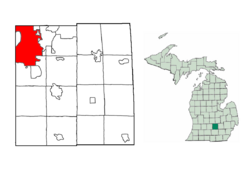
- Note 1: The city also extends into Eaton County along its southwest side. There are also two small non-contiguous tracts located in Ingham County. These sections are not highlighted on the map displayed as they are part of a 425 Agreement, meaning they do not officially count towards Lansing's area.
External links
- Allen Neighborhood Center
- Capital Area District Library
- City of Lansing
- Downtown Lansing, Inc.
- Eastside
- Greater Lansing Convention & Visitors Bureau
- Lansing Center
- Lansing150 Sesquicentennial Celebration
- Michigan News Roundup
- Michigan Walk of Fame
- Reo Town
- Lansing, Michigan is at coordinates
|
||||||||||||||||||||||||||
|
||||||||||||||||||||||||||

|

|
|||||