Lancashire
| Lancashire | |
|---|---|
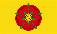 Flag of Lancashire |
|
 |
|
| Geography | |
| Status | Ceremonial & (smaller) Non-metropolitan county |
| Origin | Historic |
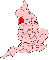
| Region | North West England |
| Area - Total - Admin. council - Admin. area |
Ranked 17th 3,079 km² (1,189 sq mi) Ranked 16th 2,903 km² (1,121 sq mi) |
| Admin HQ | Preston |
| ISO 3166-2 | GB-LAN |
| ONS code | 30 |
| NUTS 3 | UKD43 |
| Demography | |
| Population - Total (2007 est.) - Density - Admin. council - Admin. pop. |
Ranked 8th 1,451,500 472/km² (1,222/sq mi) Ranked 4th 1,168,100 |
| Ethnicity | 89.7% White British 6.0% S. Asian 2.1% Other White 0.9% Mixed 0.7% E.Asian and Other 0.5% Black 2005 Estimates |
| Politics | |
Lancashire County Council http://www.lancashire.gov.uk |
|
| Executive | Labour |
| Members of Parliament | |
| Districts | |
|
|
Lancashire (pronounced /ˈlæŋkəˌʃə/ or, less commonly, /ˈlæŋkəˌʃɪə/) is a non-metropolitan county of historic origin in the North West of England, bounded to the west by the Irish Sea. It takes its name from the city of Lancaster and is sometimes known as the County of Lancaster.[1] Lancashire County Council is based in Preston. However, Lancaster is still considered to be the county town. Commonly, Lancashire is referred to by the abbreviation Lancs, originally used by the Royal Mail. The population of the county is 1,449,700. People from the county are known as Lancastrians.
The history of Lancashire is thought to have begun with its founding in the 12th century. In the Domesday Book (1086), some of its lands had been treated as part of Yorkshire. The area in between the rivers Mersey and Ribble (referred to in the Domesday Book as "Inter Ripam et Mersham") formed part of the returns for Cheshire. Once its initial boundaries were established, it bordered Cumberland, Westmorland, Yorkshire, and Cheshire.
Lancashire emerged during the Industrial Revolution as a major commercial and industrial region. The county encompassed several hundred mill towns and collieries. By the 1830s, approximately 85% of all cotton manufactured worldwide was processed in Lancashire.[2] Accrington, Blackburn, Chorley, Darwen and Burnley were major cotton mill towns during this time. Blackpool was a major centre for tourism for the inhabitants of Lancashire's mill towns, particularly during wakes week.
The county was subject to a significant boundary reform in 1974,[3] which removed Liverpool and Manchester with most of their surrounding conurbations to form part of the metropolitan counties of Merseyside and Greater Manchester.[4] At this time, the detached Furness peninsula was made part of Cumbria. Today the county borders Cumbria, Greater Manchester, Merseyside and North and West Yorkshire. The Duchy of Lancaster exercises the right of the Crown in the area known as the County Palatine of Lancaster.
Contents |
History


The county was established in 1182[3] and later than many other counties. In the Domesday Book, its lands between the Ribble and the Mersey were known as "Inter Ripam et Mersham"[5] and were included in the returns for Cheshire.[6] Although some have taken this to mean that south Lancashire was, at that time, part of Cheshire,[7][5] it cannot be said clearly to have been part of Cheshire.[8][9][10] It is also claimed that the territory to the north formed, at that time, part of the West Riding of Yorkshire.[11] It bordered on Cumberland, Westmorland, Yorkshire, and Cheshire. The county was divided into the six hundreds of Amounderness, Blackburn, Leyland, Lonsdale, Salford and West Derby.[12] Lonsdale was further partitioned into Lonsdale North, which was the detached part north of Morecambe Bay (also known as Furness), and Lonsdale South.
The Red Rose of Lancaster is a symbol for the House of Lancaster, immortalized in the verse "In the battle for England's head/York was white, Lancaster red" (referring to the 15th century War of the Roses). The traditional Lancashire flag, a red rose on a white field, was never officially registered. When an attempt was made to register it with the Flag Institute it was found that this flag had already been officially registered by the town of Montrose, Scotland, several hundred years earlier with the Lyon Office. As the Flag Institute will not register two flags of the same design (within the UK) Lancashire's official flag is now registered as a red rose on a gold field.
Lancashire is now much smaller than its historical extent due to a local government reform.[13] In 1889 an administrative county of Lancashire was created, covering the historical county except for county boroughs such as Blackburn, Burnley, Barrow-in-Furness, Preston, Liverpool, Manchester.[14] The area covered by the Lord-Lieutenant (termed now a ceremonial county) continued to cover the entirety of the administrative county along with the county boroughs, and thus was expanded slightly whenever boroughs annexed areas in other neighbouring counties. Examples of this include Wythenshawe (an area of Manchester south of the River Mersey and historically in Cheshire), and southern Warrington. This area also did not cover the western part of Todmorden, where the ancient border between Lancashire and Yorkshire runs through the middle of the town.
During the 20th century the county became increasingly urbanised, particularly the southern part. To the existing county boroughs of Barrow-in-Furness, Blackburn, Bolton, Bootle, Burnley, Bury, Liverpool, Manchester, Oldham, Preston, Rochdale, Salford, St Helens and Wigan were added Blackpool (1904), Southport (1905), and Warrington (1900). The county boroughs also had many boundary extensions. The borders around the Manchester area were particularly complicated, with narrow protrusions of the administrative county between the county boroughs - Lees urban district formed a detached part of the administrative county, between Oldham county borough and the West Riding of Yorkshire.[15]
| Lancashire in 1961 | ||
|---|---|---|
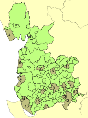 |
County boroughs | |
| 1. Burnley | 10. Oldham | |
| 2. Preston | 11. Wigan | |
| 3. Rochdale | 12. Manchester | |
| 4. Barrow-in-Furness | 13. Salford | |
| 5. Blackpool | 14. Bootle | |
| 6. Blackburn | 15. St Helens | |
| 7. Southport | 16. Liverpool | |
| 8. Bury | 17. Warrington | |
| 9. Bolton | ||
By the census of 1971 the population of Lancashire (including all its associated county boroughs) had reached 5,129,416, making it then the most populous geographic county in the UK. The administrative county of Lancashire was also the most populous of its type outside of London, with a population of 2,280,359 in 1961. On 1 April 1974, under the Local Government Act 1972, the administrative county of Lancashire was abolished, as were the county boroughs. The urbanised southern part largely became part of two new metropolitan counties. The south-western part became part of Merseyside, the south-eastern part was incorporated into Greater Manchester.[16] The new county of Cumbria took the Furness exclave.[3] The boroughs of Liverpool, Knowsley, St Helens and Sefton were entirely from Lancashire. In Greater Manchester the successor boroughs were Bury, Bolton, Manchester, Oldham (part), Rochdale, Salford, Tameside (part), Trafford (part) and Wigan. Warrington and Widnes, south of the new Merseyside/Greater Manchester border, rather than become part of Greater Manchester or Merseyside were instead made part of the new non-metropolitan county of Cheshire. The urban districts of Barnoldswick and Earby, the Bowland Rural District and the parishes of Bracewell and Brogden and Salterforth from the Skipton Rural District from the West Riding of Yorkshire became part of the new Lancashire.[4] One parish, Simonswood, was transferred from the borough of Knowsley in Merseyside to the district of West Lancashire in 1994.[17]

In 1998 the county borough system re-appeared in all but name, when Blackpool and Blackburn with Darwen became independent unitary authority areas. The Wars of the Roses tradition continued with Lancaster using as its symbol the red rose and York the white.
Pressure groups, including Friends of Real Lancashire and the Association of British Counties advocate the use of the historical boundaries of Lancashire for ceremonial and cultural purposes.[18][19]
Geography
Divisions and environs
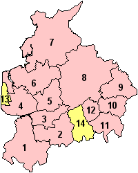
The area under the control of the county council, or shire county, is divided into a number of local government districts. They are Burnley, Chorley, Fylde, Hyndburn, Lancaster, Pendle, Preston, the Ribble Valley, Rossendale, South Ribble, West Lancashire, and Wyre.[20][21]
Blackpool and Blackburn with Darwen are unitary authorities which form part of the county for various functions such as Lord Lieutenant but do not come under county council control.[22] The Lancashire Constabulary covers the two unitary authorities.[23] The ceremonial county, the area including the unitary authorities, borders Cumbria, North Yorkshire, West Yorkshire, Greater Manchester and Merseyside, and forms part of the North West England region.[24]
Geology, landscape and ecology
The highest point of the ceremonial county is Gragareth, near Whernside, which reaches a height of 627 m (2,057 ft).[25] However, Green Hill near Gragareth has also been cited as the county top.[26] The highest point within the historic boundaries is Coniston Old Man in the Lake District at 803 m (2,634 ft).[27]
Lancashire drains west from the Pennines into the Irish Sea. Rivers in Lancashire include the Ribble, Wyre and Lune. Major tributaries of these rivers include the Calder, Crake, Darwen, Douglas, Hodder, Irwell, and Yarrow.
Politics
The county council, serving the shire county, is based in County Hall in Preston, built as a home for the Lancashire county administration (including the Quarter Sessions and Lancashire Constabulary) and opened on 14 September 1882.[28]
Local elections for 84 councillors from 84 divisions are held every four years. The council is currently controlled by the Labour Party.[29]
Duchy of Lancaster
The Duchy of Lancaster is one of two remaining royal duchies in the United Kingdom. It has large landholdings throughout the region and elsewhere, and operates as a property company, but also exercises the right of the Crown in the County Palatine of Lancaster.[30] The Duchy's website now describes the County Palatine as comprising of "the counties of Lancashire, Greater Manchester, Merseyside and the Furness area of Cumbria"[31]. These new counties include areas formerly in Cheshire and Yorkshire and it is unclear as to whether this is a reference to the whole of the new counties or just the parts that comprised the Palatine prior to the 1974 boundary changes. However, in 1992 it was stated by the Chancellor of the Duchy of Lancaster, William Waldegrave that the "boundaries of the county palatine are the same as the county boundaries which existed prior to local government reorganisation in 1973"[32]
High Sheriffs for Lancashire, Greater Manchester and Merseyside are appointed "within the Duchy and County Palatine of Lancaster".[33]
The Duchy administers bona vacantia within the County Palatine, receiving the property of persons who die intestate, and where the legal ownership cannot be ascertained.
There is no separate Duke of Lancaster, the title having merged in the Crown many centuries ago - but the Duchy is administered by the Queen in Right of the Duchy of Lancaster. A separate court system for the county palatine was finally abolished by Courts Act 1971. A particular form of The Loyal Toast is still in regular local use: 'The Queen, Duke of Lancaster'.
Economy
Lancashire in the 19th century was a major centre of industrial activity and hence of wealth. Activities included mining and textile production (particularly cotton), though on the coast there was also fishing. Historically, the docks in Preston were an industrial port, though are now disused for commercial purposes. Lancashire was historically the location of the Port of Liverpool (now on Merseyside) while Barrow-in-Furness (now in Cumbria) is famous for shipbuilding.
Today the largest private industry in Lancashire is the Defence Industry with BAE Systems Military Air Solutions division based in Warton on the Fylde Coast. The division also operates a manufacturing site in Samlesbury. Other defence firms include BAE Systems Land Systems who operate a site at Chorley, Ultra Electronics in Fulwood and Rolls-Royce Plc in Barnoldswick.
The Nuclear Power industry has a major presence with the Springfield plant at Salwick operated by Westinghouse and Heysham Power Station operated by British Energy. Other major manufacturing firms include Leyland Trucks which is a subsidiary of Paccar and builds the DAF truck range.
Other companies with a major presence in Lancashire include:
- Airline Network, an internet travel company with it's headquarters in Preston.
- BAXI, a heating equipment manufacturer which was established in Preston and which has a large manufacturing site in Bamber Bridge.
- Crown Paints, a major paint manufacturer based in Darwen.
- Enterprise Plc, one of the UK's leading support services based in Leyland.
- Hanson plc, a building supplies company which operates the Accrington brick works.
- National Savings and Investments, a state owned savings bank with major operations and the headquarters of the Premium Bond Lottery Bond in Blackpool.
- Thwaites Brewery, a regional brewery founded in 1807 by Daniel Thwaites in Blackburn.
- Xchanging, a company that provides business process outsourcing services, with operations in Fulwood.
Economic output
This is a chart of trend of regional gross value added of the non-metropolitan county of Lancashire at current basic prices published (pp.240-253) by Office for National Statistics with figures in millions of British Pounds Sterling.
| Year | Regional Gross Value Added[34] | Agriculture[35] | Industry[36] | Services[37] |
|---|---|---|---|---|
| 1995 | 13,789 | 344 | 5,461 | 7,984 |
| 2000 | 16,584 | 259 | 6,097 | 10,229 |
| 2003 | 19,206 | 294 | 6,352 | 12,560 |
Education
Lancashire has a mostly comprehensive system with four state grammar schools. Not including sixth form colleges, there are 77 state schools (not including Burnley's new schools) and 24 independent schools. The Clitheroe area also has secondary modern schools. Sixth form provision is limited at most schools in most districts, with only Fylde and Lancaster districts having mostly sixth forms at schools. The rest (most schools) depend on FE colleges and sixth form colleges, where they exist. South Ribble has the largest school population, with Fylde the smallest (only three schools). Burnley's schools have had a new broom and have essentially been knocked down and started again in 2006. There are many Catholic secondary schools in Lancashire.
Lancashire is home to four universities; Lancaster University, University of Central Lancashire, Edge Hill University and the Lancaster campus of The University of Cumbria. Additionally there are also seven colleges which offer higher education courses.
Transport
Lancashire has an extensive network of motorways covering the county and the West Coast Main Line provides direct rail links with London and other major cities, with stations at Preston and Lancaster. The county has many other railway stations. The county is served by Blackpool International Airport, however Manchester Airport in Greater Manchester is the main airport in the region. Liverpool John Lennon Airport, on Merseyside is also nearby.
Heysham and Fleetwood offer ferry services to Ireland and the Isle of Man.[38] As part of its industrial past, Lancashire gave rise to an extensive network of canals, which extend into neighbouring counties. These include the Leeds and Liverpool Canal, Lancaster Canal, Bridgewater Canal, Rochdale Canal, Ashton Canal and Manchester Ship Canal.
Demography
The major settlements in the ceremonial county are concentrated on the Fylde coast (the Blackpool Urban Area), and a belt of towns running west-east along the M65: Preston, Blackburn, Accrington, Burnley, Nelson and Colne. South of Preston are the towns of Leyland and Chorley; the three formed part of the Central Lancashire New Town designated in 1970. The north is generally sparsely populated, with Morecambe and Lancaster forming a small conurbation. Lancashire is home to a significant Asian population, numbering over 70,000 and 6% of the county's population.
Settlements
The table below has divided the settlements into their local authority district. Each district has a centre of administration; for some of these correlate with a district's largest town, while others are named after the geographical area.
| Ceremonial county | Administration borough/district | Centre of administration | Other towns, villages and settlements |
|---|---|---|---|
| Lancashire | Blackburn with Darwen Borough (Unitary) | Blackburn | Belmont, Chapeltown, Darwen, Edgworth, Tockholes |
| Blackpool Borough (Unitary) | Blackpool | Bispham, Layton | |
| Burnley Borough | Burnley | Harle Syke, Padiham, Rose Grove, Worsthorne, Cliviger. | |
| Chorley Borough | Chorley | Adlington, Clayton-le-Woods, Coppull, Croston, Eccleston, Euxton, Whittle-le-Woods | |
| Fylde Borough | Lytham St Annes | Freckleton, Kirkham, Warton, Wrea Green | |
| Hyndburn Borough | Accrington | Altham, Church, Clayton-le-Moors, Great Harwood, Oswaldtwistle, Rishton | |
| City of Lancaster | Lancaster | Bolton-le-Sands, Carnforth, Heysham, Morecambe, | |
| Pendle Borough | Nelson | Barnoldswick †, Barrowford, Brierfield, Colne, Earby †, Foulridge, Trawden | |
| City of Preston | Preston | Barton, Broughton, Fulwood, Goosnargh, Grimsargh, Whittingham | |
| Ribble Valley Borough | Clitheroe | Bolton-by-Bowland, Chipping, Hurst Green, Longridge, Read, Ribchester, Slaidburn, Whalley, Wilpshire, | |
| Rossendale Borough | Rawtenstall | Bacup, Chatterton, Edenfield, Haslingden, Helmshore, Whitworth | |
| South Ribble Borough | Leyland | Bamber Bridge, Farington, Longton, Lostock Hall, Penwortham, Samlesbury, Walton-le-Dale | |
| West Lancashire District | Ormskirk | Appley Bridge, Aughton, Banks, Bickerstaffe, Burscough, Downholland, Great Altcar, Halsall, Lathom, Parbold, Rufford, Scarisbrick, Skelmersdale, Tarleton, Upholland | |
| Wyre Borough | Poulton-le-Fylde | Churchtown, Cleveleys, Fleetwood, Garstang, Pilling, Preesall, St Michael's On Wyre, Thornton |
- This table does not form an extensive list of the settlements in the ceremonial county. More settlements can be found at Category:Towns in Lancashire, Category:Villages in Lancashire, and Category:Parishes of Lancashire.

Some settlements which were historically part of the county now fall under the counties of West Yorkshire, Cheshire, Merseyside, Greater Manchester and Cumbria:[3][4][16][39][14][40][41]
| Greater Manchester | Ashton-in-Makerfield, Ashton-under-Lyne, Bolton, Bury, Chadderton, Denton, Eccles, Farnworth, Heywood, Horwich, Hindley, Leigh, Manchester, Middleton, Oldham, Prestwich, Radcliffe, Rochdale, Salford, Swinton and Pendlebury, Tyldesley, Westhoughton, Wigan |
|---|---|
| Merseyside | Bootle, Crosby, Formby, Huyton, Kirkby, Liverpool, Maghull, Newton-le-Willows, Prescot, St Helens, Southport |
| Cumbria | Barrow-in-Furness, Coniston, Dalton-in-Furness, Grange-over-Sands, Ulverston |
| Cheshire | Warrington, Widnes |
| West Yorkshire | Todmorden |
Note: Cities are in bold
† - part of the West Riding of Yorkshire until 1974
Boundary changes to occur before 1974 include:[41]
- Todmorden (split between Lancashire and Yorkshire) entirely to West Riding of Yorkshire in 1889
- Mossley (split between Lancashire, Yorkshire and Cheshire) entirely to Lancashire in 1889
- Stalybridge, entirely to Cheshire in 1889
- the former county boroughs of Manchester and Warrington both extended south of the Mersey into historic Cheshire (areas such as Wythenshawe and Latchford)
- correspondingly, the former county borough of Stockport extended north into historic Lancashire, including areas such as Reddish and the Heatons (Heaton Chapel, Heaton Mersey, Heaton Moor and Heaton Norris).
Sport
Cricket
Lancashire County Cricket Club has been one of the most successful county cricket teams, particularly in the one-day game. It is home to England cricket team members Andrew Flintoff, James Anderson and Sajid Mahmood. Due to changes in the county boundaries, the club's home ground, County Ground, Old Trafford,[42] is now outside the county of Lancashire, being in the metropolitan borough of Trafford, Greater Manchester.
Historically important local cricket leagues include the Lancashire League and the Central Lancashire League, both of which were formed in 1892. These league clubs hire international professional players to play alongside their amateur players.
Football
Football in Lancashire is governed by the Lancashire County Football Association. Due to the County Football Associations being aligned roughly along historic county boundaries, the Lancashire County FA contains members which were founded within Lancashire as it was in the late 19th Century, but which now lie outside the county borders, such as Manchester United and Liverpool. However, the Manchester and Liverpool Football Associations operate in Greater Manchester and Merseyside respectively.
The six professional league teams based in Lancashire, as of the start of the 2008/09 season, are:
- Premier League: Blackburn Rovers
- Championship: Blackpool, Burnley and Preston North End
- League Two: Accrington Stanley and Morecambe
Rugby
Several rugby league teams are based within Lancashire including Blackpool Panthers, East Lancashire Lions and Blackpool Sea Eagles.
Rugby union teams include Fylde and Preston Grasshoppers.
Other
Lancashire has a long history of wrestling, developing its own style called Lancashire wrestling with many clubs that over the years have produced many renowned wrestlers. Some of these have crossed over into the mainstream world of professional wrestling, including Billy Riley, Davey Boy Smith, William Regal and The Dynamite Kid.
Cuisine
Lancashire is widely-known for its eponymous Lancashire Hotpot, a casserole dish traditionally made with lamb and for Lancashire cheese, reputed to be the best toasting cheese in the world. Other traditional foods from the area include:
- Bénédictine, 80% of the world's Benedictine is drunk in Burnley.
- Black peas, also known as parched peas: popular in Bolton and Preston.
- Black Pudding: long associated with the town of Bury.
- Bury Simnel: cross between a fruitcake and a biscuit. Eaten on Simnel or Mid-Lent Sunday.
- Butter Cake - slice of bread and butter.
- Clapbread: oatcake.
- Chorley cakes: from the town of Chorley.
- Ducks: faggots as in savoury ducks.
- Eccles cakes: from the town of Eccles.
- Fag Pie: pie made from chopped dried figs, sugar and lard. Associated with Blackburn and Burnley where it was the highlight of Fag Pie Sunday (Mid-Lent Sunday).
- Fish and Chips: first fish and chip shop in northern England opened in Mossley near Oldham around 1863.[43]
- Frog-i'-th'-'ole pudding: now known as toad in the hole.
- Frumenty: sweet porridge. Once a popular dish at Lancashire festivals like Christmas and Easter Monday.
- Goosnargh Cakes: Small flat shortbread biscuits with coriander or caraway seeds pressed into the biscuit before baking. Traditionally baked on feast days like Shrove Tuesday.
- Jannock: cake or small loaf of oatmeal. Allegedly introduced to Lancashire (possibly Bolton by Flemish weavers.
- Nettle Porridge: a common starvation diet in Lancashire in the early 1800s. Made from boiled stinging nettles with perhaps a handful of meal.
- Ormskirk Gingerbread: local delicacy which were sold all over South Lancashire
- Pobs, Pobbies: bread and milk.
- Potato Hotpot, a variation of the Lancashire Hotpot without meat also known as fatherless pie.
- Ran Dan: barley bread. Food of last resort for the poor at the end of the 18th century and beginning of the 19th century.
- Rag Pudding: Traditional Suet Pudding filled with Minced Meat and Onions.
- Sad Cake: A traditional cake, perhaps a variation of the more widely known Chorley cake, once common around Burnley.
- Scouse, a type of stew popular in Liverpool (historically part of Lancashire).
- Throdkins: a traditional breakfast food of the Fylde.
Places of interest
| Key | |
| Abbey/Priory/Cathedral | |
| Accessible open space | |
| Amusement/Theme Park | |
| Castle | |
| Country Park | |
| English Heritage | |
| Forestry Commission | |
| Heritage railway | |
| Historic House | |
| Museum (free/not free) | |
| National Trust | |
| Zoo | |
The following are places of interest in the ceremonial county:
- Arnside and Silverdale AONB

- Astley Green Colliery Museum, Tyldesley
- Astley Hall

- Beacon Fell

- Blackburn Cathedral

- Blackpool Pleasure Beach

- Blackpool Tower
- Blackpool Zoo

- British Commercial Vehicle Museum, Leyland
- Camelot Theme Park
- Clegg Hall
- Darwen Tower
- East Lancashire Railway

- Forest of Bowland: Area of Outstanding Natural Beauty
- Gawthorpe Hall, Padiham

- Harris Museum

- Helmshore Textile Museum
- Hoghton Tower
- Irwell Sculpture Trail
- Lancaster Castle
- Lancaster Cathedral
- Lathom Park Chapel, site of Lathom Hall, seat of the Earls of Derby
- Leighton Moss nature reserve, Royal Society for the Protection of Birds
- Martin Mere, Wildfowl and Wetlands Trust nature reserve, Burscough
- Morecambe Bay
- Museum of Lancashire

- National Football Museum
- Pendle Hill
- Pennington Flash Country Park
- The Pennines , provide great opportunity for Mountain Biking
- Rock Climbing is popular with the area having some 6,600+ routes to climb many of which are in disused quarries.
- Rufford Old Hall
- Samlesbury Hall
- St Walburge's Church
- Stonyhurst College - a Manor House dating back to 1592, now an English public school, run by the Jesuits
- Towneley Hall, Burnley
- West Lancashire Light Railway
- West Pennine Moors
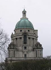
- Williamson Park and the Ashton Memorial
- Witton Country Park
- Yarrow Valley Park
Notes and References
- ↑ Vision of Britain - Lancashire
- ↑ Gibb, Robert (2005). Greater Manchester: A panorama of people and places in Manchester and its surrounding towns. Myriad. p. 13. ISBN 1-904736-86-6.
- ↑ 3.0 3.1 3.2 3.3 George, D., Lancashire, (1991)
- ↑ 4.0 4.1 4.2 Local Government Act 1972. 1972, c. 70
- ↑ 5.0 5.1 Sylvester (1980). p. 14.
- ↑ Morgan (1978). pp.269c–301c,d.
- ↑ Booth, P. cited in George, D., Lancashire, (1991)
- ↑ Harris and Thacker (1987). write on page 252:
Certainly there were links between Cheshire and south Lancashire before 1000, when Wulfric Spot held lands in both territories. Wulfric's estates remained grouped together after his death, when they were left to his brother Aelfhelm, and indeed there still seems to have been some kind of connexion in 1086, when south Lancashire was surveyed together with Cheshire by the Domesday commissioners. Nevertheless, the two territories do seem to have been distinguished from one another in some way and it is not certain that the shire-moot and the reeves referred to in the south Lancashire section of Domesday were the Cheshire ones.
- ↑ Phillips and Phillips (2002). pp. 26–31.
- ↑ Crosby, A. (1996). writes on page 31:
The Domesday Survey (1086) included south Lancashire with Cheshire for convenience, but the Mersey, the name of which means 'boundary river' is known to have divided the kingdoms of Northumbria and Mercia and there is no doubt that this was the real boundary.
- ↑ Booth, P. cited in George, D., Lancashire, (1991)
- ↑ Vision of Britain - Lancashire ancient county divisions
- ↑ Berrington, E., Change in British Politics, (1984)
- ↑ 14.0 14.1 Vision of Britain - Lancashire ancient county boundaries
- ↑ Lord Redcliffe-Maud and Bruce Wood. English Local Government Reformed. (1974)
- ↑ 16.0 16.1 Jones, B. et al, Politics UK, (2004)
- ↑ OPSI - The Cheshire, Lancashire and Merseyside (County and Metropolitan Borough Boundaries) Order 1993
- ↑ FORL Retrieved 7 Nov 2008
- ↑ ABC Counties Retrieved 7 Nov 2008
- ↑ Vision of Britain - Divisions of Lancashire
- ↑ Lancashire County Council - Lancashire districts
- ↑ OPSI - The Lancashire (Boroughs of Blackburn and Blackpool) (Structural Change) Order 1996
- ↑ Lancashire County Council - Map of Lancashire (Unitary boundaries shown)
- ↑ Government Office for the North West - Local Authorities
- ↑ BUBL Information Service - The Relative Hills of Britain
- ↑ Administrative (1974) County Tops
- ↑ Historic County Tops
- ↑ Opening of the new Town-Hall at Preston. The Times. September 15, 1882.
- ↑ Lancashire County Council - County Councillors by Area
- ↑ The Duchy of Lancaster - Boundary Map
- ↑ Duchy of Lancaster website
- ↑ House of Commons Hansard debates for 15 June 1992 (2nd paragraph in "Duchy of Lancaster" section
- ↑ High Sheriffs, The Times, March 21, 1985
- ↑ Components may not sum to totals due to rounding
- ↑ includes hunting and forestry
- ↑ includes energy and construction
- ↑ includes financial intermediation services indirectly measured
- ↑ Transport for Lancashire - Lancashire Inter Urban Bus and Rail Map (PDF)
- ↑ Vision of Britain - Lancashire boundaries 1974
- ↑ Chandler, J., Local Government Today, (2001)
- ↑ 41.0 41.1 Youngs. Guide to the Local Administrative Units of England. Volume 2. Northern England.
- ↑ LCCC contact details
- ↑ History of fish and chips
Bibliography
- Crosby, A. (1996). A History of Cheshire. (The Darwen County History Series.) Chichester, West Sussex, UK: Phillimore & Co. Ltd. ISBN 0850339324.
- Harris, B. E., and Thacker, A. T. (1987). The Victoria History of the County of Chester. (Volume 1: Physique, Prehistory, Roman, Anglo-Saxon, and Domesday). Oxford: Oxford University Press. ISBN 0197227619.
- Morgan, P. (1978). Domesday Book Cheshire: Including Lancashire, Cumbria, and North Wales. Chichester, Sussex: Phillimore & Co. Ltd. ISBN 0850331404.
- Phillips A. D. M., and Phillips, C. B. (2002), A New Historical Atlas of Cheshire. Chester, UK: Cheshire County Council and Cheshire Community Council Publications Trust. ISBN 0904532461.
- Sylvester, D. (1980). A History of Cheshire. (The Darwen County History Series). (2nd Edition.) London and Chichester, Sussex: Phillimore & Co. Ltd. ISBN 0850333849.
External links
- Lancashire Sinfonietta - Lancashire's professional orchestra
- Traditions of Lancashire, Volume 1 (of 2), by John Roby
- Lancashire Lantern, The Lancashire Life and Times E-Resource network
- Website of the film 'Catch - the hold not taken', a look at the cultural significance of wrestling in Lancashire
- Lancashire County Council - MARIO (Mapping portal)
- Map of Lancashire
- Photographs of Lancashire
- An online survey about Lancashire dialect
- The Lancashire Dialect Society
- Official Lancashire Tourism information
- Lancashire Magazine TV - Internet TV channel devoted to the county of Lancashire
- Government Office for the North West
- North West Regional Minister
- Team Lancashire
|
|||||||||||||||||
|
|||||
|
|||||