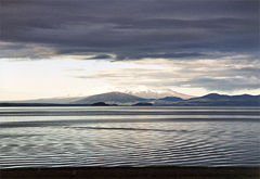
Lake Taupo
| Lake Taupo | |
|---|---|
 |
|
| Location | Taupo District, Waikato Region, North Island |
| Lake type | crater lake, oligotrophic |
| Primary inflows | Waitahanui River, Tongariro River, Tauranga-Taupo River |
| Primary outflows | Waikato River |
| Catchment area | 3,487 km² |
| Basin countries | New Zealand |
| Max. length | 46 km |
| Max. width | 33 km |
| Surface area | 616 km² |
| Average depth | 110 m |
| Max. depth | 186 m |
| Water volume | 59 km³ |
| Residence time (of lake water) | 10.5 years |
| Shore length1 | 193 km |
| Surface elevation | ~356 m |
| Islands | Motutaiko Island |
| 1 Shore length is not a well-defined measure. | |
Lake Taupo is a lake situated in the North Island of New Zealand. It has a perimeter of approximately 193 kilometres, a deepest point of 186 metres and a surface area of 616 square kilometres. The largest lake by surface area in the country, it is drained by the Waikato River, while its main tributaries are the Waitahanui River, the Tongariro River, and the Tauranga-Taupo River. It is a noted trout fishery with stocks of introduced brown trout and rainbow trout.
Contents |
Lake formation and volcanism

The lake lies in a caldera created following a huge volcanic eruption (see supervolcano) approximately 26,500 years ago. According to geological records, the volcano has erupted 28 times in the last 27,000 years. It has predominantly erupted rhyolitic lava although Mount Tauhara formed from dacitic lava.
The largest eruption, known as the Oruanui eruption, ejected an estimated 1,170 cubic kilometres of material and caused several hundred square kilometres of surrounding land to collapse and form the caldera. The caldera later filled with water, eventually overflowing to cause a huge outwash flood.[1]
Several later eruptions occurred over the millennia before the most recent major eruption, which occurred in 180 CE. Known as the Hatepe eruption, it is believed to have ejected 100 cubic kilometres of material, of which 30 cubic kilometres was ejected in the space of a few minutes. This was one of the most violent eruptions in the last 5,000 years (alongside the Tianchi eruption of Baekdu at around 1000 and the 1815 eruption of Tambora), with a Volcanic Explosivity Index rating of 7. The eruption column was twice as high as the eruption column from Mount St. Helens in 1980, and the ash turned the sky red over Rome and China. The eruption devastated much of the North Island and further expanded the lake. Fortunately the area was uninhabited by humans at the time of the eruption, since New Zealand was not settled by the Māori until several centuries later at the earliest. Taupo's last known eruption occurred around 210 CE, with lava dome extrusion forming the Horomatangi Reefs, but that eruption was much smaller than the 180 CE eruption.
The 180 eruption was one of the largest in recorded history. The skies and sunsets formed from this eruption were noted by Roman and Chinese observers.
Underwater hydrothermal activity continues near the Horomatangi vent,[2] and the volcano is currently considered to be dormant rather than extinct.
Biota
Native species in the lake are northern koura or crayfish (Paranephrops planifrons) and kokopu or whitebait (Galaxias species). The lake is noted for stocks of brown trout (Salmo trutta) and rainbow trout (Oncorhynchus mykiss), introduced from Europe and California respectively in the late nineteenth century. There has also been a subsequent introduction of smelt (Retropinnidae species) as a food for the trout.
A community of sponges and associated invertebrates live around the underwater geothermal vents.[2]
Tourism


Tourism is a major business for the area, attracting over 1.2 million tourists per year. The fact that the lake is the largest fresh water lake in Australasia, and approximately the same size as Singapore, ensures it is a huge 'must do' component to many tourists. The Christmas and New Year period is an exceptionally busy time of the year for Lake Taupo, with holiday makers needing to book up to 12 months in advance.
The town of Taupo is popular for events like the annual Lake Taupo Cycle Challenge in which cycling enthusiasts cycle around the lake, this usually takes about 4–10 hours depending on the cyclist. Hundreds of volunteers from the Taupo township help out to ensure the famous event is a success.
Taupo is host to the Oxfam Trailwalker, a charity ultra-challenge held annually on 100 km course in April.
Another activity the region is famous for is skydiving, a sport also heavily advertised.
See also
- List of volcanoes in New Zealand
- Taupo Volcanic Zone
References
- Ben G. Mason; David M. Pyle, and Clive Oppenheimer (2004). "The size and frequency of the largest explosive eruptions on Earth" (PDF). Bulletin of Volcanology 66 (8): 735–748. doi:.
- Smithsonian Institution Global Volcanism Program: Lake Taupo
- ↑ Manville, Vern & Wilson, Colin J. N. (2004). "The 26.5 ka Oruanui eruption, New Zealand: a review of the roles of volcanism and climate in the post-eruptive sedimentary response". New Zealand Journal of Geology & Geophysics 47: 525–547. http://www.rsnz.org/publish/nzjgg/2004/042.php.
- ↑ 2.0 2.1 C. E. J. de Ronde, P. Stoffers, D. Garbe-Schönberg, B. W. Christenson, B. Jones, R. Manconi, P. R. L. Browne, K. Hissmann, R. Botz, B. W. Davy, M. Schmitt and C. N. Battershill (2002). "Discovery of active hydrothermal venting in Lake Taupo, New Zealand". Journal of Volcanology and Geothermal Research 115: 257–275. doi:.