Lake Lucerne
| Lake Lucerne Vierwaldstättersee |
|
|---|---|
 |
|
 |
|
| Location | Central Switzerland |
| Primary inflows | Reuss River Sarner Aa Engelberger Aa Muota |
| Primary outflows | Reuss River |
| Catchment area | 2,124 km² |
| Basin countries | Switzerland |
| Surface area | 113.6 km² |
| Average depth | 104 m |
| Max. depth | 214 m |
| Water volume | 11.8 km³ |
| Residence time (of lake water) | 3.4 years |
| Shore length1 | 143.7 km |
| Surface elevation | 433 m |
| Frozen | in the 17th and 19th century; Lucerne Bay and Lake Alpnach in 1929 and 1963 |
| Islands | Altstad-Insel (islet) |
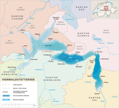
| Sections/sub-basins | Lake Uri (Urnersee), Treib basin, Gersau Basin, Weggis/Vitznau Basin, Lake Küssnacht, Kreuztrichter basin, Lake Alpnach (Alpnachersee), Lucerne Bay |
| Settlements | Lucerne (see article) |
| 1 Shore length is not a well-defined measure. | |
Lake Lucerne (German: Vierwaldstättersee, lit. "Lake of the Four Forest Cantons") is a lake in central Switzerland, the fourth largest in the country. It lies approximately at co-ordinates .
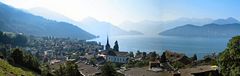
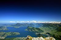
The lake is a complicated shape, with bends and arms reaching from the city of Lucerne into the mountains. It has a total area of 114 km² (44 sq mi), an elevation of 434 m (1,424 ft), and a maximum depth of 214 m (702 ft). Its volume is 11.8 km³. Much of the shoreline rises steeply into mountains up to 1,500 m above the lake, resulting in many picturesque views including those of Mount Rigi and Mount Pilatus.
It borders on the three original Swiss cantons of Uri, Schwyz, and Unterwalden (which today is divided into the Cantons of Obwalden and Nidwalden), as well as the canton of Lucerne, thus the name. Many of the oldest communities of Switzerland are along the shore, including Küssnacht, Weggis, Vitznau, Gersau, Brunnen, Altdorf, Buochs, and Treib. In addition, the meadow of the Rütli, traditional site of the founding of the Swiss Confederation, is on the southeast shore of the lake.
The Reuss River enters the lake at Flüelen (in the canton of Uri, the part called Urnersee) and exits at Lucerne. The lake also receives the Muota (at Brunnen) Engelberger Aa (at Buochs), the Sarner Aa (at Stansstad).

It is possible to circumnavigate the lake by road, though the route is slow, twisted, and goes through tunnels part of the way. Dozens of steamers ply between the different towns on the lake. It is a popular tourist destination, both for native Swiss and foreigners, and there are many hotels and resorts along the shores.
The level of the lake is maintained by a pioneering needle dam in the Reuss River in Lucerne, just upstream from the Spreuerbrücke.
Cities and places on Lake Lucerne
| Left shore ¹ | Right shore |
|---|---|
¹ At the entry of the Reuss River: the western, later southern shore.
Gallery
