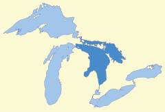
Lake Huron
| Lake Huron | |
|---|---|
 |
|
| Location | North America |
| Group | Great Lakes |
| Lake type | Glacial |
| Primary inflows | Straits of Mackinac, St. Marys River |
| Primary outflows | St. Clair River |
| Catchment area | 74,700 sq mi (193,000 km2) |
| Basin countries | Canada, United States |
| Max. length | 206 mi (332 km) |
| Max. width | 152 mi (245 km) |
| Surface area | 23,010 sq mi (59,600 km2)[1] |
| Average depth | 195 ft (59 m) |
| Max. depth | 750 ft (230 m)[1] |
| Water volume | 849 cu mi (3,540 km3) |
| Residence time (of lake water) | 22 years |
| Shore length1 | 3,825 mi (6,156 km) |
| Surface elevation | 577 ft (176 m)[1] |
| Islands | Manitoulin |
| Sections/sub-basins | Georgian Bay, North Channel |
| Settlements | Bay City, Alpena, Cheboygan, St. Ignace, Port Huron in Michigan; Goderich, Sarnia in Ontario |
| References | [1] |
| 1 Shore length is not a well-defined measure. | |
Lake Huron, bounded on the west by the U.S. state of Michigan, and on the east by the province of Ontario, Canada, is one of the five Great Lakes of North America. The name of the lake is derived from early French explorers who named it based on the Huron people inhabiting the region.
Contents |
Geography
Lake Huron is the second-largest of the Great Lakes, with a surface area of 23,010 square miles (59,596 km²)—nearly the size of West Virginia, making it the third largest fresh water lake on earth (4th largest lake if the saline Caspian Sea is included). It contains a volume of 850 cubic miles (3,540 km³), and a shoreline length of 3,827 miles (6,157 km).
The surface of Lake Huron is 577 feet (176 m) above sea level. The lake's average depth is 195 feet (59 m), while the maximum depth is 750 feet (229 m). It has a length of 206 miles (332 km) and a greatest breadth of 183 miles (245 km).
Important cities on Lake Huron include: Bay City, Alpena, Rogers City, Cheboygan, St. Ignace, and Port Huron, Michigan; and Goderich, and Sarnia, Ontario Canada.
A notable feature of the lake is Manitoulin Island, which separates the North Channel and Georgian Bay from Lake Huron's main body of water. It is the world's largest freshwater island.
Geology
Lake Huron is separated from Lake Michigan, which lies at the same level, by the narrow Straits of Mackinac, making them geologically and hydrologically the same body of water (sometimes called Lake Michigan-Huron). Lake Superior is slightly higher than both. It drains into the St. Marys River at Sault Ste. Marie which then flows southward into Lake Huron. The water then flows south to the St. Clair River, at Port Huron, Michigan and Sarnia, Ontario.
The Great Lakes Waterway continues thence to Lake St. Clair; the Detroit River and Detroit, Michigan; into Lake Erie and thence – via Lake Ontario and the St. Lawrence River – to the Atlantic Ocean.
Like the other Great Lakes, it was formed by melting ice as the continental glaciers retreated towards the end of the last ice age.
History
Since its French discoverers knew nothing as yet of the other lakes, they called it La Mer Douce, the fresh-water sea. A Sanson map in 1656 refers to the lake as Karegnondi, which means simply 'Lake' in the Petan Indian language.[2]
Lake Huron was generally labeled "Lac des Hurons" (Lake of the Huron Indians) on most early maps.
Storm of 1913
On November 9, 1913, a great storm rolled across Lake Huron and with it, 235 seamen died, ten ships sank and another twenty plus were driven ashore. The storm raged for sixteen hours.[3]
The Matoa had passed between Port Huron, Michigan and Sarnia, Ontario just after midnight. On the 9th, just after six in the morning, the Senator pushed upstream. Less than an hour later, the Manola passed through. Captain Frederick W. Light of the Manola reported that both the Canadian and the American weather stations had storm signals flying from their weather towers. [4] Following behind at 7:00 a.m. that Sunday, the Regina steamed out of Sarnia into the northwest gale. The warnings now had been up for four hours [5] The Manola passed the Regina off Port Sanilac, 22 miles up the lake. Captain Light determined that if it continued to deteriorate, he would seek shelter at Harbor Beach, Michigan, another 30 miles up lake. There, he could seek shelter behind the breakwater. Before reaching Harbor Beach, the winds turned to the northeast and the sea began to rise. It would be noon before he reached Harbor Beach and ran for shelter. The seas were so violent that the Manola touched bottom entering the harbor. With help from a tug the Manola tied up to the break wall with eight lines. It was about 3:00 p.m. that Sunday that the Manola was tied down and the crew prepared to drop anchor. As they worked, the cables began to snap from winds pressure against the hull. To keep from being pushed aground, they kept their bow into the wind with the engines running half to full in turns. Yet the ship still drifted 800 feet before they arrested the drift.[6] The waves broke over the ship and the windows were broken out. The seas were so rough; that the crew reported seeing the cement break wall was move and chunks of cement peeled off.[7]
Meanwhile, fifty miles further up the lake, the Matoa, and Captain Hugh McLeod had to ride out the storm without a safe harbor. [8] The Matoa would be found stranded on the Port Austin reef when the winds subsided. [9] It was Monday noon before the winds let up and not until 11:00 p.m. Monday night before Capt. Light determined it to be safe to continue his journey. [10]
Shipwrecks of Lake Huron
Over 1000 wrecks lie under the waters of Lake Huron, including the first vessel to travel the great lakes. The Griffon built in 1679 on the eastern shore of Lake Erie, near Buffalo, New York, Sieur de la Salle navigated across Lake Erie, up the Detroit River, Lake St. Clair and the St. Clair River out into Lake Huron. Passing the Straits of Mackinac, La Salle and the Griffon made land fall on Washington Island, the off the tip of the Door Peninsula on Wisconsin’s side of Lake Michigan. Here, the La Salle filled the Griffon with pelts and in late November 1679 sent the Griffon back to Buffalo, never to be seen again. Two wrecks have been identified as the Griffon, although neither has gained credit as the actual wreck. Blown by a fierce storm after leaving, the Griffin ran before the storm. The people of Manitoulin Island say that the wreck in Mississagi Straits at the western tip of the island is the Griffon. Meanwhile, others near Tobermory say that the wreck on Russell Island, 150 miles further east in Georgian Bay is the Griffin. [11]
Saginaw Bay
185 of 1000+ wrecks[12] are within the waters of Saginaw Bay.
Matoa, A propeller freighter, 2,311gross tons, built 1890, Cleveland, wrecked, 1913, Port Austin Reef[13]
Georgian Bay, North Channel
212 of more than 1000 [14] of Lake Huron's wrecks are within Georgian Bay. The Bay is the largest bay on Lake Huron. With its 30,000 islands, it offers recreational interest and dangers for all ships passing through.
Manola, a propeller freighter of 2,325 gross tons. Built in 1890, by the Globe Shipping Company of Cleveland, Ohio. Operated by the Minnesota Steamship Company (Cleveland) from 1890-1901, by the Pittsburgh Steamship Company from 1901-1918. On January 25, 1918, the Manola was sold to the U.S. Shipping Board. It was sold again in 1920 to the Canada Steamship Lines, Ltd and renamed the Mapledawn. It became stranded on November 20, 1924 on Christian Island[15] in Georgian Bay. It was headed for Port McNichol, Ontario. It was declared a total loss after two weeks. Salvagers were able to recovered c.75,000 bushels of barley for delivery to Midland, Ontario. [16]
Ecology
Lake Huron has a lake retention time of 22 years.
Lake Huron is home to a variety of fish and plant life, such as the now extinct Deepwater cisco, many of them being home to the other Great Lakes such as carp, chinook salmon, a variety of panfish, bass, pike, and catfish. Lake Huron along with the other great lakes have suffered recently due the introduction of various invasive species.
See also
- Drummond Island
- Georgian Bay
- Hurricane Huron
- Les Cheneaux Islands
- Mackinac Island
- Michigan lighthouses
- Saginaw Bay
- Sauble Beach
- Shipwrecks of the 1913 Great Lakes storm and List of victims of the 1913 Great Lakes storm
- Thunder Bay
- Wasaga Beach
Great Lakes in General
- Great Lakes
- Great Lakes Areas of Concern
- Great Lakes census statistical areas
- Great Lakes Commission
- Great Recycling and Northern Development Canal
- Great Storm of 1913
- International Boundary Waters Treaty
- List of cities along the Great Lakes
- Seiche
- Sixty Years' War for control of the Great Lakes
- Third Coast
Notes
- ↑ 1.0 1.1 1.2 1.3 Wright, John W. (ed.); Editors and reporters of The New York Times (2006). The New York Times Almanac (2007 ed.). New York, New York: Penguin Books. pp. 64. ISBN 0-14-303820-6.
- ↑ Origin of names of the Great Lakes
- ↑ True Tales of the Great Lakes, by Dwight Boyer; p212
- ↑ True Tales of the Great Lakes, by Dwight Boyer; p266
- ↑ True Tales of the Great Lakes, by Dwight Boyer; p268
- ↑ Freshwater Fury by Frank Barcus, pg 72
- ↑ True Tales of the Great Lakes, by Dwight Boyer, pg 269
- ↑ True Tales of the Great Lakes, by Dwight Boyer, pg 272,3
- ↑ Shipwrecks of Lake Huron . . . The Great Sweetwater Sea, Jack Parker, Avery Color Studios, Au Train, Michigan, 1986, pg 56
- ↑ Freshwater Fury by Frank Barcus, pg 73
- ↑ Shipwrecks of Lake Huron . . . The Great Sweetwater Sea, Jack Parker, Avery Color Studios, Au Train, Michigan, 1986, pg 25-6
- ↑ Shipwrecks of Lake Huron . . . The Great Sweetwater Sea, Jack Parker, Avery Color Studios, Au Train, Michigan, 1986, pg 50-61
- ↑ Shipwrecks of Lake Huron . . . The Great Sweetwater Sea, Jack Parker, Avery Color Studios, Au Train, Michigan, 1986, pg 56
- ↑ Shipwrecks of Lake Huron . . . The Great Sweetwater Sea, Jack Parker, Avery Color Studios, Au Train, Michigan, 1986, pg 65-77
- ↑ Shipwrecks of Lake Huron . . . The Great Sweetwater Sea, Jack Parker, Avery Color Studios, Au Train, Michigan, 1986, pg 71
- ↑ Great Lakes Vessels Index; Historical Collections of the Great Lakes; Bowling Green State University, Bowling Green, Ohio
Further reading
- Hyde, Charles K., and Ann and John Mahan. The Northern Lights: Lighthouses of the Upper Great Lakes. Detroit: Wayne State University Press, 1995. ISBN 0814325548 ISBN 9780814325544.
- Oleszewski, Wes, Great Lakes Lighthouses, American and Canadian: A Comprehensive Directory/Guide to Great Lakes Lighthouses, (Gwinn, Michigan: Avery Color Studios, Inc., 1998) ISBN 0-932212-98-0.
- Penrod, John, Lighthouses of Michigan, (Berrien Center, Michigan: Penrod/Hiawatha, 1998) ISBN 9780942618785 ISBN 9781893624238.
- Penrose, Laurie and Bill, A Traveler’s Guide to 116 Michigan Lighthouses (Petoskey, Michigan: Friede Publications, 1999). ISBN 0923756035 ISBN 9780923756031
- Wagner, John L., Michigan Lighthouses: An Aerial Photographic Perspective, (East Lansing, Michigan: John L. Wagner, 1998) ISBN 1880311011 ISBN 9781880311011.
- Wright, Larry and Wright, Patricia, Great Lakes Lighthouses Encyclopedia Hardback (Erin: Boston Mills Press, 2006) ISBN 1550463993
External links
- EPA's Great Lakes Atlas
- Fish Species of Lake Huron
- Great Lakes Coast Watch
- Lake Huron Binational Partnership Action Plan
- Lake Huron Data
- Lake Huron GIS
- Michigan DNR map of Lake Huron
- Lighthouses
- Bibliography on Michigan lighthouses
- Interacitvew map of lighthouses, Georgian Bay, Lake Huron
- Interactive map of lighthouses in North and East Lake Huron
- Interactive map of lighthouses in North and West Lake Huron
- Terry Pepper on lighthouses of the Western Great Lakes
- Wagner, John L., Beacons Shining in the Night, Michigan lighthouse bibliography, chronology, history, and photographs, Clarke Historical Library, Central Michigan University
|
|||||