Lake Constance
| Lake Constance Bodensee |
|
|---|---|
 |
|
 |
|
| Location | Germany, Switzerland, Austria |
| Primary inflows | Rhine |
| Primary outflows | Rhine |
| Catchment area | 11500 km² |
| Basin countries | Germany, Switzerland, Austria, Liechtenstein |
| Max. length | 63 km |
| Max. width | 14 km |
| Surface area | 571 km² |
| Average depth | 90 m |
| Max. depth | 254 m |
| Water volume | 55 km³ |
| Residence time (of lake water) | 4.3 years |
| Surface elevation | 395 m |
| Frozen | 1795, 1830, 1880 (partial), 1963 |
| Islands | Mainau, Reichenau, Lindau |
| Sections/sub-basins | Obersee, Überlinger See; Untersee, Zeller See, Gnadensee |
| Settlements | see list |
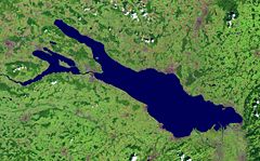
Under the designation Lake Constance (German: Bodensee) one summarizes the three independent bodies of water Obersee ("Lake Superior"), Untersee ("Lake Inferior") and Seerhein ("Lake Rhine"), lying in the northern Alpine foreland. Thus, it concerns two independent lakes (standing waters) and one connecting river (current water).
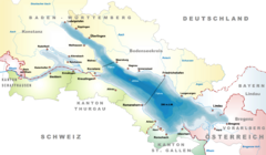
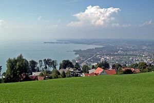
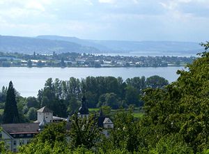
Lake Constance is situated in Germany, Switzerland and Austria near the base of the alps. Specifically, it's shorlines lie in the German federal-states of Bavaria and Baden-Württemberg, the Austrian federal-state of Vorarlberg and the Swiss cantons of Thurgau and St. Gallen. The Rhine flows into it from the south. It is approximately located at .
Lake Constance was first mentioned by the Roman geographer Pomponius Mela about AD 43. He noted that the Rhine flows through two lakes, and gave them the Latin names Lacus Venetus (Obersee) and Lacus Acronius (Untersee[1]). Pliny the Elder used the name Lacus Brigantinus, after the Roman city of Brigantium (today Bregenz). The lake is also colloquially known as the Swabian Sea[2] (das Schwäbische Meer).
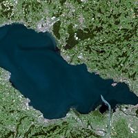
The freshwater lake sits at 395 m above sea level and is Central Europe's third largest, after Lake Balaton and Lake Geneva. It is 63 km long, and at its widest point, nearly 14 km. It covers approximately 571 km² (208 mi²) of total area.[3] The greatest depth is 252 m in the middle of the eastern part (Obersee). Its volume is approximately 55 km³. The lake has four parts: Obersee (main, 476 km²), Überlinger See (north, 61 km²), Untersee (west, 63 km²), and the Zeller See and Gnadensee (northwest). The regulated Rhine flows into the lake in the southeast, through the Obersee, the city of Konstanz and the Untersee and flows out near Stein am Rhein. Lake Constance provides fresh water to many cities in south Germany.
Lake Constance was formed by the Rhine Glacier during the ice age. The Rhine, the Bregenzer Ache, and the Dornbirner Ache carry sediments from the Alps to the lake, thus gradually decreasing the depth of the lake in the southeast.
The lake was frozen in the years 1077 (?), 1326 (partial), 1378 (partial), 1435, 1465 (partial), 1477 (partial), 1491 (partial?), 1517 (partial), 1571 (partial), 1573, 1600 (partial), 1684, 1695, 1709 (partial), 1795, 1830, 1880 (partial), and 1963.
Approximately 1000 tons of fish were caught by 150 professional fishermen in 2001 which was below the previous ten year average of 1200 tons per year. The Lake Constance trout (Salmo trutta) was almost extinct in the 1980s due to pollution, but thanks to protective measures has made a significant return.
The lake itself is an important drinking water source for south-west Germany called Bodenseewasserversorgung.[4]
Car ferries link Romanshorn, Switzerland to Friedrichshafen, and Konstanz to Meersburg.
Contents |
Geographic oddity
There is no legally binding agreement as to where the boundaries lie between Switzerland, Germany and Austria where these three countries meet in Lake Constance. While Switzerland holds the view that the border runs through the middle of the lake, Austria is of the opinion that the lake stands in condominium of all the states on its banks. Germany holds no unambiguous opinion. Legal questions pertaining to ship transport and fishing are regulated in separate treaties.
Disputes naturally arise. One concerns a houseboat which was moored in two states, another concerns the rights to fish in the Bay of Bregenz. In relation to the latter, an Austrian family was of the opinion that it alone had the right to fish in broad portions of the bay. However, this was accepted neither by the Austrian courts nor by the organs and courts of the other states.[5]
Recent floods
- A 100-year flood around June 1999 (Pfingsthochwasser 1999) raised the level about 2 metres above normal, flooding harbors and many shoreline buildings and hotels.
- In late August 2005, heavy rains raised the level by more than 70 cm in a few days. The rains caused widespread flooding and washed out highways and railroads.
Islands in the lake
- Mainau Island
- Reichenau Island
- Lindau
Towns and cities at the lake


Austria
- Hard
- Hörbranz
- Bregenz
- Lochau
- Höchst
- Fussach
- Gaissau
Germany
From the entry of the Rhine, on the northern or right shore:
- On the Upper Lake (Obersee) and Überlinger See
- Lindau (in Bavaria)
- Wasserburg
- Nonnenhorn
- Kressbronn (in Baden-Württemberg)
- Langenargen
- Eriskirch
- Friedrichshafen
- Immenstaad
- Hagnau
- Stetten
- Meersburg
- Uhldingen-Mühlhofen (on Überlinger See)
- Überlingen
- Sipplingen
- Bodman-Ludwigshafen
- Konstanz with suburbs
- Wallhausen
- Dingelsdorf
- Litzelstetten
- On the lower lake (Untersee)
- Reichenau (including the island with same name)
- Allensbach (on Gnadensee)
- Radolfzell (on Zellersee)
- Moos
- Gaienhofen
- Öhningen
Switzerland
From the entry of the Rhine, on the southern or left shore:
- On the Upper Lake (Obersee)
- Altenrhein, St. Gallen
- Rorschach, St. Gallen
- Horn, Thurgau
- Steinach, St. Gallen
- Arbon, Thurgau (as all the following)
- Frasnacht
- Egnach
- Romanshorn
- Uttwil
- Kesswil
- Güttingen
- Altnau
- Landschlacht
- Münsterlingen
- Bottighofen
- Kreuzlingen (and Konstanz, Germany)
- On the Rhine
- Gottlieben
- On the Lower Lake (Untersee)
- Ermatingen
- Mannenbach
- Berlingen
- Steckborn
- Mammern
- Eschenz
- Stein am Rhein, Schaffhausen
See also
- 2002 Überlingen Mid-Air Collision
- Württembergischer Yacht Club
- Lake Constance is also the title of a track from Mike Oldfield's The Millennium Bell album
References
- ↑ Not to be confused with Lake Untersee in the Antarctic.
- ↑ Gordon McLachlan. The Rough Guide to Germany. Rough Guides Ltd. London, 2004. ISBN 184353293X.
- ↑ Image #432, Flying Camera Satellite Images 1999, Lloyd Reeds Map Collection, McMaster University Library.
- ↑ "Bodensee-Wasserversorgung", German language Wikipedia.
- ↑ David Mark and Barry Smith, et al., Bizarre Shapes: 100 Geographic Monsters.
External links
- Bodensee-Hochwasser (German) waterlevels
- Internationale Bodenseekonferenz
- EuroRegio Bodensee Statistics
- Lake Constance: pictures
- Bibliography on Water Resources and International Law Peace Palace Library
- Lake Constance/Bodensee Lessons learned managing the lake
- Karl Heinz Burmeister: Lake Constance in German, French and Italian in the online Historical Dictionary of Switzerland.
- Living Lakes Partnership news updates