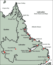
Labrador
| Labrador | |
|---|---|
 |
|
| Flag of Labrador, with Coat of Arms (de facto) |
|
| Motto Latin: Munus splendidum mox explebitur The splendid task will soon be fulfilled |
|
 |
|
| Geography | |
| Area: | 269,073.3 km² (103,895.5 sq mi) |
| Water area: | 31,340 km² (12,101 sq mi) (4%) |
| Coastline: | 7,886 km (4,900 mi) |
| Highest Point: | Mount Caubvik (1652 m, 5,420 ft) |
| Longest River: | Churchill River (856 km, 532 mi) |
| Admin HQ: | Happy Valley-Goose Bay |
| Demographics | |
| Population(2006): | 26,364[1] |
| Largest City: | Happy Valley-Goose Bay[2] 7,572 (2006) |
| Politics | |
| Government of Newfoundland & Labrador http://www.gov.nl.ca |
|
| Members of the Parliament of Canada: | 1 |
| Members of the Newfoundland and Labrador House of Assembly: | 4 |
Labrador is a region of Atlantic Canada. Together with the island of Newfoundland from which it is separated by the Strait of Belle Isle, it constitutes the province of Newfoundland and Labrador. The region is part of the much larger Labrador Peninsula. The area was known by the Norse as Markland.
The population of Labrador is 26,364 (2006 census[3]), including some 30 percent Aboriginal peoples, including Inuit, Innu, and Métis. Labrador’s area (including associated small islands and inland water surfaces) is 294,330 square kilometres (113,641 sq mi).[4] It has a land area of 269,073.3 km² (103,895.5 sq mi),[5] approximately the size of New Zealand. Its former capital was Battle Harbour.
The name "Labrador" is one of the oldest names of European origin in Canada, almost as old as the name "Newfoundland". It is named after Portuguese explorer João Fernandes Lavrador who, together with Pêro de Barcelos, were the second party of European explorers (after the Vikings) to sight it in 1498.
Most non-Aboriginal settlement of Labrador occurred due to fishing villages, missions, and fur trading outposts; modern settlements have been created as a result of iron ore mining, hydroelectric developments, and military installations. Until modern times, difficult sea travel and lack of general transportation facilities discouraged settlement. In the 1760s, Moravian missionaries began settling, building missions and often sharing in the fur trade with the Hudson's Bay Company, which was the dominant force on the peninsula until 1870. Claims have persisted concerning the Labrador Peninsula with Quebec, although they were settled by judicial decision in 1927 by the Judicial Committee of the Privy Council.
John James Audubon called Labrador "the most extensive and dreariest wilderness I have ever beheld".[1] (See Also: Creation, ISBN 1-58567-410-9)
Contents |
Modern Labrador

Just like its island neighbour Newfoundland, early settlement in Labrador was tied to the sea as demonstrated by the Montagnais, Innu and Inuit, although these peoples also made significant forays throughout the interior as well. European settlement was largely concentrated in coastal communities, particularly those south of Hamilton Inlet, and are among Canada's oldest European settlements. Extremely poor, both European and First Nations settlements along coastal Labrador came to benefit from cargo and relief vessels that were operated as part of the Grenfell Mission (see Sir Wilfred Grenfell). Throughout the 20th century, coastal freighters and ferries operated initially by the Newfoundland Railway and later Canadian National Railways/CN Marine/Marine Atlantic became a critical lifeline for communities on the coast, which for the majority of that century, did not have any road connection with the rest of North America.
Labrador has played strategic roles in both the Second World War and the Cold War. In the early 1940s a German U-boat crew installed an automated weather station on the northern tip of Labrador near Cape Chidley, nicknamed Weather Station Kurt. The station only broadcast weather observations to the German navy for a few days but was not discovered until the 1980s when a historian, working with the Canadian Coast Guard, identified its location.
The Canadian government built a major air force base at Goose Bay, at the head of Lake Melville during the Second World War, a site selected because of its topography, access to the sea, defensible location, and minimal fog. During the Second World War and the Cold War, the base was also home to American, British, and later German, Netherlands, and Italian detachments. Today, CFB Goose Bay is the largest employer for the community of Happy Valley-Goose Bay.
Additionally, both the United States Air Force and Royal Canadian Air Force built and operated a number of radar stations along coastal Labrador as part of the Pinetree Line, Mid-Canada Line and DEW Line systems. Today the remaining stations are automated as part of the North Warning System, however the military settlements during the early part of the Cold War surrounding these stations have largely continued as local Innu and Inuit populations have clustered near their port and airfield facilities.
During the first half of the 20th century, some of the largest iron ore deposits in the world were discovered in the western part of Labrador and adjacent areas of Quebec. Deposits at Mont Wright, Schefferville, Labrador City, and Wabush drove industrial development and human settlement in the area during the post-war years.
The present community of Labrador West is entirely a result of the iron ore mining activities in the region. The Iron Ore Company of Canada operates the Quebec, North Shore, and Labrador Railway to transport ore concentrate 500 miles south to the port of Sept-Îles, Quebec for shipment to steel mills in North America and elsewhere.
During the 1960s, the Churchill River was diverted at Churchill Falls which resulted in the flooding of an enormous area — today named the Smallwood Reservoir. Both a hydroelectric generating station and a transmission line were built in the neighbouring province of Quebec.
In the 1970s-2000s the Trans-Labrador Highway was built in stages to connect various inland communities with the North American highway network at Mont Wright, Quebec (which in turn is connected by a highway running north from Baie-Comeau, Quebec). A southern extension of this highway has opened in stages during the early 2000s and is resulting in significant changes to the coastal ferry system in the Strait of Belle Isle and southeastern Labrador. It is worth noting that these "highways" are so called only because of their importance to the region; they would be better described as roads, and are not completely paved.
A study on a fixed link to Newfoundland, in 2004, recommended that a tunnel under the Strait of Belle Isle, being a single railway that would carry cars, buses and trucks, was technologically the best option for such a link. However, the study also concluded that a fixed link was not economically viable. Conceivably, if built with federal aid, the 1949 terms of union would be amended to remove ferry service from Nova Scotia to Port-aux-Basques across the Cabot Strait.
Although a highway link will soon (2009 or 2010) be complete across Labrador, this route is somewhat longer than a proposed Quebec North Shore highway that presently does not exist. Part of the "highway", Route 389, starting approximately 212 km (132 mi) from Baie Comeau to 482 km (299 mi) is of an inferior alignment, and from there to 570 km (354 mi), the provincial border, is an accident-prone section notorious for its poor surface and sharp curves. Local citizens are urging realignment of this road, a vital work if it were to be the routing to the fixed link to Newfoundland.
Route 389 and the Trans-Labrador Highway were added to Canada's National Highway System in September 2005.
The Labrador boundary dispute

The border between Labrador and Canada was set March 2, 1927, after a tortuous five-year trial. In 1809 Labrador had been transferred from Lower Canada to Newfoundland, but the landward boundary of Labrador had never been precisely stated. [6] Newfoundland argued it extended to the height of land, but Canada, stressing the historical use of the term "Coasts of Labrador", argued the boundary was one statute mile (1.6 km) inland from the high-tide mark. As Canada and Newfoundland were separate countries, but both members of the British Empire, the matter was referred to the Judicial Committee of the Privy Council (in London), which set the Labrador boundary mostly along the coastal watershed. One of Newfoundland's conditions for joining Confederation in 1949 was that this boundary be entrenched in the Canadian constitution. While this border has not been formally accepted by the Quebec government, the Henri Dorion[2] Commission (Commission d'étude sur l'intégrité du territoire du Québec) concluded in the early 1970s that Quebec no longer has a legal claim to Labrador. Still, Quebec government publications sometimes ignore or modify the Labrador boundary, especially the southern segment.[3]
![[3]](http://www.dgeq.qc.ca/img/carte_2001/images/region09.gif)
The province's name change to Newfoundland and Labrador was meant to emphasize its claim to Labrador, as well as Labrador's unique culture and contributions to the province. (See Newfoundland and Labrador for more details.)
Separation from Newfoundland
A Royal Commission in 2002 determined that there is a certain amount of public pressure from Labradorians to break off from Newfoundland and become a separate province or territory. Some of the Innu nation would have the area become a homeland for them, much as Nunavut is for the Inuit; a 1999 resolution of the Assembly of First Nations claimed Labrador as a homeland for the Innu and demanded recognition in any further constitutional negotiations regarding the region.[4] The Inuit self-government region of Nunatsiavut was recently created through agreements with the provincial and federal governments.
Timeline
- 11th century : Probable visit by Leif Ericson. See Markland.
- 1498: Sighted by João Fernandes Lavrador
- 1498: Visited by John Cabot
- 1500: Visited by Gaspar Corte-Real
- 1534: Visited by Jacques Cartier
- 1763: Labrador is transferred from the French colony Canada to the British colony Newfoundland as per the Treaty of Paris.
- 1774: Labrador is transferred (along with Anticosti Island and the Magdalen Islands) to the Province of Quebec.
- 1791: Labrador becomes part of Lower Canada when Quebec is divided into two colonies.
- 1809: Labrador (from Cape Chidley to the mouth of the Saint-Jean River) is transferred back to Newfoundland.
- 1825: The north shore of the Gulf of St. Lawrence west of Blanc-Sablon and south of 52° north is separated from Labrador and transferred back to Lower Canada.
- 1892: Wilfred Grenfell, medical missionary and social activist, first came to Labrador.
- 1927: The Labrador boundary dispute is settled.
- 1941: Canada builds the air base at Goose Bay.
- 1949: Labrador becomes part of Canada when Newfoundland joins Confederation.
- 2001: The province changes its name to Newfoundland and Labrador.
- 2007: The province and Federal Government of Canada sign an agreement to establish Nunatsiavut
Demographics
| Town | 2006 | 2001 |
|---|---|---|
| Happy Valley-Goose Bay | 7,572 | 7,969 |
| Labrador City | 7,240 | 7,744 |
| Wabush | 1,739 | 1,894 |
| Nain | 1,034 | 1,159 |
| L'Anse-au-Loup | 593 | 635 |
| Cartwright | 552 | 629 |
| Hopedale | 530 | 559 |
| North West River | 492 | 551 |
| Port Hope Simpson | 529 | 509 |
| Forteau | 448 | 477 |
| Factor | Labrador | Canada |
|---|---|---|
| Male/Female Split | 50.6/49.4 | 49.0/51.0 |
| Median Age | 32.6 | 37.6 |
| Immigrant (born outside Canada) Pop. | 1.5% | 18.4% |
| Aboriginal Pop. | 34.9% | 3.3% |
| Religion - Catholic | 28.4% | 43.6% |
| Religion - Protestant | 67.4% | 29.2% |
| Religion - Other | 0.8% | 10.6% |
| No Religion | 3.4% | 16.5% |
| Median Income (age 15+) | $19,229 | $22,120 |
| Unemployment Rate | 19.1% | 7.4% |
See also
- Landsat Island
- Torngat Mountains National Park Reserve
References
- ↑ "2006 Census Data - GeoSearch2006". Statistic Canada (2008-06-26). Retrieved on 2008-08-28.
- ↑ "2006 Census". Retrieved on 2007-04-17.
- ↑ "2006 Census Data - GeoSearch2006". Statistic Canada (2008-06-26). Retrieved on 2008-08-28.
- ↑ "NL Government website: Areas". Retrieved on 2007-08-26.
- ↑ "Stats Canada LAbrador information". Retrieved on 2007-08-27.
- ↑ "LABRADOR-CANADA BOUNDARY" (HTML). marianopolis (2007). Retrieved on 2008-03-20. "Labrador Act, 1809. - An imperial act (49 Geo. III, cap. 27), 1809, provided for the re-annexation to Newfoundland of 'such parts of the coast of Labrador from the River St John to Hudson's Streights, and the said Island of Anticosti, and all other smaller islands so annexed to the Government of Newfoundland by the said Proclamation of the seventh day of October one thousand seven hundred and sixty-three (except the said Islands of Madelaine) shall be separated from the said Government of Lower Canada, and be again re-annexed to the Government of Newfoundland.'"
- The Lure of the Labrador Wild, by Dillon Wallace (ISBN 1-4043-1537-3; July 2002)
- Labrador by Choice, by Benjamin W. Powell Sr. C.M. 1979
- The Story of Labrador, by B. Rompkey (2005)
- Labrador, by Robert Stewart (1977)
- Community Profile: Labrador: Division No. 10, Newfoundland and Labrador; Statistics Canada
External links
- Audio recording of a traditional ghost story from Labrador, Canada
- Project Gutenberg e-text of Dillon Wallace's The Lure of the Labrador Wild
- Labrador information page
- Newfoundland and Labrador Defense League - Advocacy Group
- Trans-Labrador Highway website Detailed information about traveling in Labrador
|
|||||||||||||||||||||||
|
||||||||||||||
|
|||||