Khyber Pass
| Khyber Pass | |
|---|---|
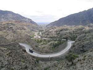 Looking back towards Pakistan, on the Pakistan side of the Khyber Pass |
|
| Elevation | 1,070 m |
| Location | Pakistan/Afghanistan |
| Range | Safed Koh |
| Topo map | himalaya |


The Khyber Pass, (also spelled Khaiber or Khaybar) (Urdu: درہ خیبر) (altitude: 1,070 m , 3,510 ft) is the mountain pass that links Pakistan and Afghanistan.
Throughout history it has been an important trade route between Central Asia and South Asia and a strategic military location. The summit of the Khyber Pass is 5 km inside Pakistan at Landi Kotal and it cuts through the northeastern part of the Safed Koh mountains which themselves are a far southeastern extension of the Hindu Kush range. For centuries,it has been a trade route between south and north Asia.
Contents |
Geography
As with many passes, the start and finish are ill-defined. Many definitions state that the Khyber Pass starts from near Jamrud, Pakistan (491 m - 1,611 ft), 15 km west of Peshawar and ends west of Torkham, Afghanistan, a winding road of 48 km which passes Fort Maude and Ali Masjid to reach a narrowest point of just 15 metre wide between canyon walls. The summit at Landi Kotal at is followed by a steep decline to Michni Kandao, Landi Khana and the Afghan border at Torkham. Here the gradient becomes easier as the pass exits at Haft Chah opening onto the Dakka plain. The road/highway was built by the British in 1879 and the railway from Jamrud to Landi Khana was built over six years by Victor Bayley and completed in 1925.
From Dakka, the Kabul River flows to Peshawar through the Loe Shilman Gorge, a less direct and more difficult route to travel, chosen by Alexander the Great when he crossed into South Asia in 326 BC in an attempt to conquer the Indus Valley.
History
In some versions of the Aryan migration theory, the Indo-Aryans migrated to India via the Khyber Pass. Recorded invasions through the Khyber begin with the conquests of Alexander the Great and also include later Muslim invasions of South Asia, culminating with the establishment of the Mughul Empire from 1526. From India, the British invaded Afghanistan and fought three Afghan Wars in 1839-42, 1878-80, and 1919. George Molesworth, a member of the British force of 1919, summarised: "Every stone in the Khyber has been soaked in blood." Rudyard Kipling called it "a sword cut through the mountains."
To the north of the Khyber Pass lies the country of the Mullagoris. To the south is Afridi Tirah, while the inhabitants of villages in the Pass itself are Afridi clansmen. Throughout the centuries the Pashtun clans, particularly the Afridis and the Afghan Shinwaris, have regarded the Pass as their own preserve and have levied a toll on travellers for safe conduct. Since this has long been their main source of income, resistance to challenges to the Shinwaris' authority has often been fierce.

The pass became widely known to thousands of Westerners and Japanese who traveled it in the days of the Hippie trail, taking a public or private bus or car from Kabul or the Afghan border, on the Pakistani side. People were advised not to wander away from the road; a quick daylight passage was then made. Monuments left by British Army units, as well as hillside forts, could be viewed from the highway.
The area of the Khyber Pass has been connected with a counterfeit arms industry, making AK-47s and Martini-Henry rifles, among others including pistols and submachine guns using local steel and blacksmiths' forges.
Torkham Gate is a major trade route between Pakistan and Afghanistan.
Bibliography
- Molesworth, Lt-Gen. G.N., Afghanistan 1919 (Asia Publishing House, 1962). Describes in detail the author's passage through the Khyber Pass, when he was Adjutant of the 2/Somerset Light Infantry.
- Victor Bayley CIE CBE. "Permanent Way through the Khyber", Jarrolds 1934. Illustrated with photos, the author describes the construction of the railway.
- V. Bayley. (as above). 'Adventures through the Khyber' . In a breach of copyright this was published in 1998 by Gyan Publishing House, India. it uses the same text and illustrations as the first mentioned (the copyright holder lives in London) .
See also
- North-West Frontier Province
- Khyber Agency
- Federally Administered Tribal Areas
- Durand Line
- Pakistan Standard Time
- Carry On... Up the Khyber