Kharkiv Oblast
| Kharkiv Oblast Харківська область Kharkivs’ka oblast’ |
|||||
|
|||||
| Nickname: Харківщина (Ukrainian) Kharkivshchyna (transliteration) |
|||||
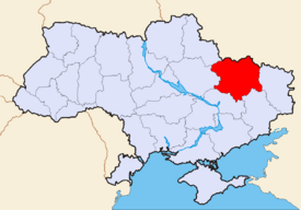 Location of Kharkiv Oblast (red) on the map of Ukraine (blue). |
|||||
| Administrative center | Kharkiv | ||||
| Largest cities | |||||
| Governor | Arsen Avakov (?) | ||||
| Oblast council | |||||
| – Chairman | ? (?) | ||||
| – № of seats | ? | ||||
| Established | |||||
| Subdivisions | |||||
| – Raions | 27 | ||||
| – Cities of oblast subordinance | 7 | ||||
| – Cities (total) | 17 | ||||
| – Towns | 61 | ||||
| – Villages | 1,683 | ||||
| Area | Ranked 4th | ||||
| – Total | 31,415 km² | ||||
| – Land | ? km² | ||||
| – Water | ? (?%) | ||||
| Population | Ranked 3 | ||||
| – Total (2006) | 2,808,701 | ||||
| – Density | 91 p/ km² | ||||
| – Average salary | UAH ? (?%) | ||||
| Time zone | EET +2 | ||||
| – Summer (DST) | EEST +3 | ||||
| Abbreviations | |||||
| – Postal code | ? | ||||
| – ISO 3166-2 | UA-63 | ||||
| – FIPS 10-4 | UP07 | ||||
| – Telephone code | +380-57 | ||||
| – Licence plate | |||||
| Official website | www.regionnet.kharkov.ua | ||||
| Verkhovna Rada site | |||||
Kharkiv Oblast (Ukrainian: Харківська область, translit. Kharkivs’ka oblast’; also referred to as Kharkivshchyna - Ukrainian: Харківщина) is an oblast (province) in eastern Ukraine. The oblast borders Russia to the north, Luhansk Oblast to the east, Donetsk Oblast to the south-east, Dnipropetrovsk Oblast to the south-west, Poltava Oblast to the west and Sumy Oblast to the north-west. The area of the oblast is 31,400 km², corresponding to 5.2% of the total territory of Ukraine.
The oblast is the third most populous region of Ukraine, with a population of 2,857,751 (as of 2004[update]), more than half (1.5 million) of whom live in the city of Kharkiv, the oblast's administrative center. While the Russian language is primarily spoken in the cities of Kharkiv oblast, elsewhere in the oblast most inhabitants speak a mixture of Russian and Ukrainian called Surzhyk.
In April 2006, the Kharkiv oblast council voted to give the Russian language official status in the oblast, despite that Ukraine's constitution prescribes Ukrainian as the only official language.[1]
Contents |
History
The territory of the Kharkiv oblast has been permanently inhabited since at least the late Paleolithic period (10,000–12,000 years ago) but archaeological evidence indicates a human (Neanderthal) presence as early as the Mousterian period some 80,000 years ago.
The territory was relatively sparsely inhabited until the 1630s, when large numbers of Ukrainians began to settle there before and during the Chmielnicki Uprising. Most of the settlers were migrants from the Dnieper region, many of whom were fleeing fighting between Cossacks, Poles and Tatars. They called the newly settled region the Sloboda Ukraine ("word sloboda means fortress, mostly made of wood") or Slobozhanshchina, as the area is still sometimes called, and ruled it from the newly established fortress-city of Kharkov (founded 1656). In 1654, the region was incorporated into Muscovy (and subsequently the Russian Empire) under the terms of the Treaty of Pereyaslav.
Over the next 340 years, the area became heavily Russified. Kharkov itself became one of the cultural and administrative centres of the Russian Empire in the mid-18th century, and served as the capital of the Ukrainian SSR from 1919 until 1934, when the Soviet authorities moved the capital back to Kiev. The modern Kharkiv oblast is a relatively recent creation, having been established on 27 February 1932. Kharkiv Oblast together with Kiev Oblast was two most suffering regions, during the man-made famine (Holodomor) of early 1930s. It saw major fighting during World War II in several Battles of Kharkov between 1941 and 1943.
Points of Interest
The following sites were nominated for the Seven Wonders of Ukraine.
- DerzhProm Building
- Pokrov monastery (Kharkiv)
- Skovoroda museum
Demographics
Its population (as of 2001) is 2,895,800 million (1328900 males (45,9 %), 1566900 females (54,1%)).
As of the 2001 census, the ethnic groups within the Kharkiv Oblast are:
- Ukrainians - 70.7%,
- Russians - 25.6% ,
- Belorussians - 0.5%
- Jews - 0.4%,
- Armenians - 0.4%,
- Azeris - 0.2%,
- Georgians - 0.15%,
- Tatars - 0.14%,
- others - 2.1%,;
the groups by native language:
Economy
The Kharkiv oblast has a primarily industrially based economy, including engineering, metallurgy, manufacturing, production of chemicals and food processing. It also has an important agricultural sector with 19,000 square kilometres of arable land (comprising 5.9% of the total arable lands of Ukraine).
Also in Kharkiv is the Airplane plant for space controlling systems. It is a major center for all branches of engineering, from large-scale manufacture to microelectronics. Also situated in Kharkiv Oblast is a gas field, which is one of the biggest in the Ukraine.
Subdivisions

The Kharkiv Oblast is administratively subdivided into 27 raions (districts), as well as 7 cities (municipalities) which are directly subordinate to the oblast government: Chuhuiv, Izium, Kupiansk, Liubotyn, Lozova, Pervomaiskyi, and the administrative center of the oblast, Kharkiv.
| In English | In Ukrainian | Administrative Center | |
|---|---|---|---|
| Balakliyskyi Raion | Балаклійський район Balakliys'kyi raion |
Balakliia (City) |
|
| Barvinkivskyi Raion | Барвінківський район Barvinkivs'kyi raion |
Barvinkove (City) |
|
| Blyzniukivskyi Raion | Близнюківський район Blyzniukivs'kyi raion |
Blyzniuky (Urban-type settlement) |
|
| Bohodukhivskyi Raion | Богодухівський район Bohodukhivs'kyi raion |
Bohodukhiv (City) |
|
| Borivskyi Raion | Борівський район Borivs'kyi raion |
Borova (Urban-type settlement) |
|
| Chuhuivskyi Raion | Чугуївський район Chuhuivs'kyi raion |
Chuhuiv (City) |
|
| Derhachivskyi Raion | Дергачівський район Derhachivs'kyi raion |
Derhachi (City) |
|
| Dvorichanskyi Raion | Дворічанський район Dvorichans'kyi raion |
Dvorichna (Urban-type settlement) |
|
| Iziumskyi Raion | Ізюмський район Iziums'kyi raion |
Izyum (City) |
|
| Kehychivskyi Raion | Кегичівський район Kehychivs'kyi raion |
Kehychivka (Urban-type settlement) |
|
| Kharkivskyi Raion | Харківський район Kharkivs'kyi raion |
Kharkiv (City) |
|
| Kolomatskyi Raion | Коломацький район Kolomats'kyi raion |
Kolomak (Urban-type settlement) |
|
| Krasnohradskyi Raion | Красноградський район Krasnohrads'kyi raion |
Krasnohrad (City) |
|
| Krasnokutskyi Raion | Краснокутський район Krasnokuts'kyi raion |
Krasnokutsk (Urban-type settlement) |
|
| Kupyanskyi Raion | Куп'янський район Kupyans'kyi raion |
Kupiansk (City) |
|
| Lozivskyi Raion | Лозівський район Lozivs'kyi raion |
Lozova (City) |
|
| Novovodolazkyi Raion | Нововодолазький район Novovodolaz'kyi raion |
Nova Vodolaha (Urban-type settlement) |
|
| Pechenizkyi Raion | Печенізький район Pecheniz'kyi raion |
Pechenihy (Urban-type settlement) |
|
| Pervomaiskyi Raion | Первомайський район Pervomais'kyi raion |
Pervomaiskyi (City) |
|
| Sakhnovshchynskyi Raion | Сахновщинський район Sakhnovshchyns'kyi raion |
Sakhnovshchyna (Urban-type settlement) |
|
| Shevchenkivskyi Raion | Шевченківський район Shevchenkivs'kyi raion |
Shevchenkove (Urban-type settlement) |
|
| Valkivskyi Raion | Валківський район Valkivs'kyi raion |
Valky (City) |
|
| Velykoburlutskyi Raion | Великобурлуцький район Velykoburluts'kyi raion |
Velykyi Burluk (Urban-type settlement) |
|
| Vovchanskyi Raion | Вовчанський район Vovchans'kyi raion |
Vovchansk (City) |
|
| Zachepylivskyi Raion | Зачепилівський район Zachepylivs'kyi raion |
Zachepylivka (Urban-type settlement) |
|
| Zmiivskyi Raion | Зміївський район Zmiyivs'kyi raion |
Zmiiv (City) |
|
| Zolochivskyi Raion | Золочівський район Zolochivs'kyi raion |
Zolochiv (Urban-type settlement) |
Nomenclature
Most of Ukraine's oblasts are named after their capital cities, officially referred to as "oblast centers" (Ukrainian: обласний центр, translit. oblasnyi tsentr). The name of each oblast is a relative adjective, formed by adding a feminine suffix to the name of respective center city: Kharkiv is the center of the Kharkivs’ka oblast’ (Kharkiv Oblast). Most oblasts are also sometimes referred to in a feminine noun form, following the convention of traditional regional place names, ending with the suffix "-shchyna", as is the case with the Kharkiv Oblast, Kharkivshchyna.
- See also: Romanization of Ukrainian
Notes
- ↑ “Kharkiv Oblast” at the Encyclopedia of Ukraine.
External links
- Kharkiv Oblast Facts & Figures
- Kharkiv Oblast statistics
- Maps of Kharkiv oblast Cities, Towns and Villages
- About Kharkiv Oblast
- Post codes directory of Kharkiv Oblast
|
||||||||||||||||||||

|
|||||||||||||||||