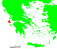
Kefalonia
| Kefalonia Κεφαλονιά |
|
|---|---|
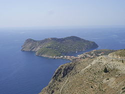 Panoramic view of Assos |
|
| Geography | |
 |
|
| Island Chain: | Ionian Islands |
| Area:[1] | 906.5 km² (350 sq.mi.) |
| Highest Mountain: | Megas Soros (1,627 m (5,338 ft)) |
| Government | |
| Periphery: | Ionian Islands |
| Prefecture: | Kefalonia and Ithaka |
| Capital: | Argostoli |
| Statistics | |
| Population: | 36,404 (as of 2001) |
| Density: | 40 /km² (104 /sq.mi.) |
| Postal Code: | 280 xx |
| Area Code: | 267x0 |
| License Code: | KE |
| Website | |
| www.kefalonia.gr | |
The island of Kefalonia, also known as Cephallenia, Cephallonia, Kefallinia, or Kefallonia (Ancient Greek: Κεφαλληνία; Modern Greek: Κεφαλλονιά or Κεφαλονιά; Italian: Cefalonia), is the largest of the Ionian Islands in western Greece, with an area of 350 sq. miles. It is also the larger of the two islands forming the Kefalonia and Ithaka Prefecture, and contains eight of the prefecture's nine municipalities or communities. (Ithaca is on a separate island.)
The island is named after the mythological figure Cephalus (Ciphalis), although some hold its name literally means "island with a head", referring to the island's shape; the name "Ciphalis" is derived from the Greek word for "head".
Contents |
Geography


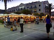
The capital of the Kefalonia prefecture is Argostoli. The island's population is nearly 45,000; it previously was home to the fastest growing population in Greece, with a growth rate of 35% to 40% during the 1990s. It was officially 36,404 at the census of 2001. The size of the island is ca. 800 km² (300 mi²), and the present population density is 55 people per km² (140/mi²), with Argostoli home to one-third of the island's habitants. Lixouri is the second major settlement, and the two towns together account for almost two-thirds of the prefecture's population.
Kefalonia is located in the heart of an earthquake zone, and dozens of minor or unrecorded tremors occur each year. In 1953, a massive earthquake almost destroyed settlement on the island, leaving only Fiscardo in the north untouched.
Most of the Kefalonia population have surnames ending in "-atos". Almost every community in Kefalonia has a name ending in "-ata", such as Valsamata, Frangata, Lourdata, Favata, Delaportata, and others.
In the ancient period, before it was named Kefalonia, the island was known to have a population of only 100 to 300; at the ancient founding of Kefalonia, the population trebled to around 500 - 1,000 people. The population grew steadily, until it reached 10,000 in the mid-20th century, with the total topping 20,000 by the 1970s.
Mountains
Kefalonia's highest mountain is Mount Ainos, with an elevation of 1628m (almost the same elevation as Denver, Colorado in North America); to the west-northwest are the Paliki mountains, where Lixouri is sited, with other mountains taking in Gerania and Agia Dynati.
Forestry
Forestry is rare on the island; however its timber output is one of the highest in the Ionian islands, although lower than that of Elia in the Peloponnese. Forest fires were common during the 1990s and the early 2000s. These fires still pose a major threat to the population of Kefalonia.
Agriculture
The primary agricultural occupations of Kefalonia are animal breeding and olive growing, with the remainder largely composed of grain and vegetables. Most vegetable production takes place on the plains, which cover less than 15% of the island; the majority of the island is rugged and mountainous, suitable only for goats. Less than a quarter of the island's land is arable.
The majority of Kefalonians lived in rural areas before the 1970s, while today the urban population accounts for two-thirds of the prefecture, and the other third remain in rural towns and villages close to farmland.
Harbours and ports
There are five harbours and ports in the prefecture: four main harbours on the island, Same or Sami, and a major port with links to Patras and Ithaca. Poros, in the south, has ferry routes to Kyllini; Argostoli, in the west, is the largest port, for local boats and ferries to Zante and regularly to Lixouri; Fiscardo, in the north, has links to Lefkas and Ithaca. There is room for about 100 small boats in Argostoli, where the port stretches 1 kilometre around the bay, while Lixouri is situated 4 km across the bay from Argostoli, on the Lixouri peninsula. There is a road connection to the rest of the island, but driving from Lixouri to Argostoli involves a 30 km detour.
Beaches
- Atheras Beach
- Katelios
- Mounda Bay, near Kateleios
- Myrtos Beach
- Lepeda Beach (south of Lixouri in the Paliki
- Petani Beach (North of Lixouri in the Paliki
- Vatsa Bay (south of Lixouri in the Paliki
- Xi beach (south of Lixouri in the Paliki
Capes
- Cape Agios Georgios (Kefalonia) (lat: 38.1667/38°10' N, long: 20.43333/20°26' E)
- Cape Kounopetra
Towns
Since 1997 the island is divided into 8 communities or towns. These are:
|
|
See also: List of settlements in the Kefalonia and Ithaka prefecture
Main Sights


Nature
The most important natural sight might may be the mellisani and the Drogarati cave. The top of the mountain Ainos is covered with Abies cephalonica trees and is declared a natural park.
Archaeology
In late 2006 a Roman grave complex was uncovered as excavations took place for a new hotel in Fiscardo. The structures date to Roman times -- between the second century B.C. and the fourth century A.D. Archaeologists described it as the most important find of its kind ever made in the Ionian Islands. Inside the tomb five burial sites were found, including a large vaulted grave and a stone coffin, along with gold earrings and rings, gold leaves that may have been attached to ceremonial clothing, glass and clay pots, bronze artefacts decorated with masks, a bronze lock and copper coins. The tomb had escaped the attentions of grave robbers and remained undisturbed for thousands of years. In a tribute to Roman craftsmanship, when the tomb opened the stone door easily swung open on its stone hinges. Almost next to the tomb a Roman theatre was discovered, so well preserved that the metal joints between the seats were still intact.
Monasteries
Across the broader island two large monasteries are to be found: the first is that of Haghia Panagia, in Markopoulo to the southeast, and the other lies on the road between Argostoli and Michata, on a small plain surrounded by mountains. This second has an avenue of about 200 trees lined from NW to SE with a circle in the middle, and is the monastery of Agios Gerasimos, patron saint of the island whose relics is on show for veneration at the old church of the monastery
Museums
- Korgialeneios Museum (under the Korgialeneios Library) in Argostoli
- Kosmetatos Foundation in Argostoli
- Archaeological Museum in Argostoli
- Iakovatios-Library in Lixouri
- Museum in Fiscardo
History


Legend
The island received its name from the mythical hero Cephalus, who arrived at the island as a refugee from Athens, displacing the island's initial inhabitants, who were known as Taphians (Teloboes - Τηλοβόες or Taphioi).
Odysseus' home?
Homer offers 26 descriptions of specific places on Odysseus' home island, but these do not match the modern island of Ithaca. For instance, the modern Ithaca faces east, and is mountainous -- it does not "lie low".
It has been suggested that Kefalonia and Ithaca once may have been joined, because Homer describes Ithaca as being both much larger than it now is, and on the final edge of Greece "facing the western sunset". Geographical data also suggest that the islands once may have been connected.
Robert Bittlestone, in his book Odysseus Unbound, has suggested that Paliki, now a peninsula of Kefalonia, was a separate island during the late Bronze Age, and it may be this that Homer was referring to when he described Ithaca. Bittlestone also suggests that migrants from Paliki may have carried the Odyssey tale with them as they migrated during the Greek Dark Ages, first to the mainland and finally to the eastern Aegean, where tradition places Homer's birthplace: this would account for the epic's detailed knowledge of Paliki. A project starting in the Summer of 2007, and lasting three years, will examine the geological makeup of Paliki. Using high tech equipment normally used for oil exploration, a Dutch based company sponsored by the Greek Geological Society, will attempt to determine if Paliki was once a separate island, possibly Ithaca.[2] In the Southwest of the island, in the area of Leivatho, an ongoing archaeological field survey by the Irish Institute at Athens has discovered dozens of sites, with dates ranging from the Palaeolithic to the Venetian period.
Venetian rule
During the Middle Ages there existed the County palatine of Cephalonia and Zakynthos under the Kingdom of Naples and later the Venetian Republic.
In the 16th to 18th centuries, it was one of the largest exporters of currants in the world, providing with Zakynthos and owned a large shipping fleet, even commissioning ships from the Danzig shipyard. The towns and villages mostly were built high on hilltops, to prevent attacks from raiding parties of pirates that sailed the Ionian Sea during the 1820s.
French, Ottoman/Russian and British Rule
From 1797 to 1798, the island was part of the French départment Ithaque. From 1799 to 1807, it was part of the Septinsular Republic, nominally under sovereignty of the Ottoman Empire but protected by Russia. After a renewed period under French control (1807-1809), it was liberated by Britain and became part of the British-controlled United States of the Ionian Islands from 1815 to 1864.
Union with Greece
In 1864, Kefalonia, together with all the other Ionian Islands, became a full member of the Greek state.
World War II
- Further information: Axis occupation of Greece during World War II
In World War II, the island was occupied by Axis powers. Until late 1943, the occupying force was predominantly Italian -- the Acqui division plus Navy personnel totalled 12,000 men -- but about 2,000 troops from Nazi Germany were also present. The island was largely spared the fighting, until the armistice with Italy concluded by the Allies in September 1943. Confusion followed on the island, as the Italians were hoping to return home, but German forces did not want the Italians' munitions to be used eventually against them; Italian forces were hesitant to turn over weapons for the same reason. As German reinforcements headed to the island the Italians dug in and, eventually, after a referendum among the soldiers as to surrender or battle, they fought against the new German invasion. The fighting came to a head at the siege of Argostoli, where the Italians held out. Ultimately the German forces prevailed, taking full control of the island, and six thousand of the nine thousand surviving Italian soldiers were executed as a reprisal by German forces. While the war ended in central Europe in 1945, Kefalonia remained in a state of conflict due to the Greek Civil War. Peace returned to Greece and the island in 1949.
The Great Earthquake of 1953
Kefalonia is just to the east of a major tectonic fault, where the European plate meets the Aegean plate at a slip boundary. This is similar to the more famous San Andreas Fault. There are regular earthquakes along this fault.
A series of four earthquakes hit the island in August 1953, and caused major destruction, with virtually every house on the island destroyed. The third and most destructive of the, quakes took place on August 12 1953 at 09:24 UTC (11:24 local time), with a magnitude of 7.3 on the Richter scale. Its epicentre was directly below the southern tip of Kefalonia, and caused the entire island to be raised 60cm higher, where it remains, with evidence in water marks on rocks around the coastline.
This 1953 disaster caused huge destruction, with only regions in the north escaping the heaviest tremors and houses there remaining intact. Damage was estimated to run into tens of millions of dollars, equivalent to billions of drachmas, but the real damage to the economy occurred when residents left the island. An estimated 100,000 of the population of 125,000 left the island soon after, seeking a new life elsewhere.
Recent history
The forest fire of the 1990s caused damage to the island's forests and bushes, especially a small scar north of Troianata, and a large area of damage extending from Kateleios north to west of Tzanata, ruining about 30 square kilometres of forest and bushes and resulting in the loss of some properties. The forest fire scar was seen for some years.
In mid-November 2003, an earthquake measuring 5.3 on the Richter scale caused minor damage to business, residential property, and other buildings within the Argostoli periphery. Damages were in the €1,000,000 range.
On the morning of Tuesday September 20, 2005, an early-morning earthquake shook the south-western part of the island, especially near Lixouri and its villages. The earthquake measured 4.9 on the Richter scale, and its epicentre was located off the island at sea. Service vehicles took care of the area, and no damage was reported.
Between January 24 and 26 of 2006, a major snowstorm blanketed the entire island, causing extensive blackouts.
The island was recently struck yet again by another forest fire in the south of the island, beginning on Wednesday July 18, 2007 during an unusual heatwave, and spreading slowly. Firefighters along with helicopters and planes battled the blaze for some days and the spectacle frightened residents on that area of the island. The fire later disintegrated, having consumed thousands of hectares of forests and bushes. It transformed a natural beauty into an undemanding scenery.
Culture
Literature and film
Many authors wrote about an island, but the most known was the novel Captain Corelli's Mandolin, by English author Louis de Bernières. The novel is believed to be based on events that occurred in the picturesque village of Farsa, just outside of Argostoli. The love story comprising the theme of the book is set before and after the Acqui Division massacre,[1] during the Second World War, and the film adaptation was released in 2001.
During filming there was lively debate between the production team, local authorities as well as groups of citizens, as to the complex historical details of the island's antifascist resistance. As a result political references were omitted from the film, and the romantic core of the book was preserved, without entering complex debates around the island's history. In 2005 Ennio Morricone made his film Cefalonia, also about the massacre.
Tourism
A large number of tourists visit Kefalonia during the peak season but, as one of the largest islands in Greece, it is well-equipped to handle visitors. Most tourists stay in or around Lassi, a serene resort a few kilometres from Argostoli, and their numbers have increased since the best-seller, Captain Corelli's Mandolin, was made a film (2001) shot on the island itself. Many people from all over Greece and the world visit Kefalonia. Many tourists come from Italy mostly because of its close location.
Recreation
The island is covered by dense vegetation and offers a great range of natural beauty, including beaches -- many of them inaccessible from land -- and spectacular caves. Mirtos, the most famous of these beaches, is a major tourist attraction, and has been ranked fifth worldwide for its beauty. Fishing is very common throughout the waters within and around the island, and the harbours of Argostoli and Lixouri are the main fishing centres. Overfishing can be a problem in Kefalonia, and in the Ionian area generally.
Notable persons
- Juan de Fuca (Ioannis Phokas) (1536-1602), captain and explorer
- Constantine Phaulkon (1647-1688) adventurer, first counsellor to King Narai of Ayutthaya
- Nikolaos Xydias Typaldos (1826-1909) painter
- Marinos Antypas (1872-1907), lawyer and journalist, one of the country's first socialists
- Spyridon Marinatos (1901-1974) archaeologist
- Antiochos Evangelatos (1903-1981) composer and conductor
- Nikolaos Platon (1909-1992), archaeologist
- Nikos Kavadias (1910-1975) poet and author
- Antonis Tritsis (1937-1992), politician, mayor of Athens
- Andreas Gerasimos Michalitsianos (1947-1997), Greek-American astronomer and a NASA astrophysicist
- Athanassios Fokas (*1952), mathematician
- Keti Garbi (*1963), singer
- John Varvatos, fashion designer
- Marinos Charbouris: engineer, who transported a giant rock from Finland to Saint Petersburg for the construction of the statue of Peter the Great.
- Gerasimos D. Danilatos: Physicist and inventor of ESEM
Antonios Maratos: celebrity haircutter
Sports

Baseball
- AINOS Kefalonias (2nd place in 2004)
Football
- See also: Kefalonia-Ithaca Football Clubs Association
|
|
|
|
Others
- Nautical Racing Club of Kefalonia and Ithaca
Transportation

Roads
First larger road where made by the english in the 19th century. In the 20th century asphalted road were build, and since 1995 almost all streets connecting villages and beaches are covered with asphalt. since ca. 2000 the Lixouri bypass was built and a four lane street south of Argostoli was constructed.
Some important roads include:
- Greek National Road 50, commonly Argostoli-Sami Road
- Argostoli-Poros Road
- Argostoli-Fiskardo Road (with link to Lixouri)
- Road linking Poros and Sami
Airport
Kefalonia has one airport, Kefalonia Island International Airport, with a runway around 2.4 km. in length, located about 10 km south of Argostoli. Almost every scheduled flight is an Olympic route, flying mainly to and from Athens, although there is an Ionian Island Hopper www.airsealines.com service 3 times a week calling at Kefalonia, Zante and Lefkas. In summer the airport handles a number of charter flights from all over Europe.
Higher Education
- Technical Educational Institution of the Ionian Islands, Argostoli Campus (Department of Biological Agriculture and Department of Public Relations and Comunication)
- Technical Educational Institution of the Ionian Islands, Lixouri Campus (Department of Business Administration & Music instruments and Department of Business Administration)
- National Merchant Marine Academy, Argostoli
- The Music School of Kefalonia - Rokos Vergotis Conservatory, Argostoli
Media
Legal Media
Media that are approved by the N.M.C - National Media Council, [Greek: ΕΣΡ - Εθνικό Συμβούλιο Ραδιοτηλεώρασης)]
Television Kefallonia has not LEGAL local TV stations, Television is not characterized "LOCAL" by the laws in Greece. TV stations are characterized "REGIONAL" and "NATIONAL" by the Greek Laws and the Hellenic Constitution. Some of the Regional Stations of the Ionian Islands and/or Western Greece: Super B Art TV
Radio Kefallonia has 5 legal radio stations witch are: (sorted by the last audience research at Jan/2007, committed by VPRC, Metron Analysis and MRB Hellas SA)
- Ionian Galaxy 90.8
- Kiss Fm Kefalonia 100.6 (former Radio Argostoli)
- Radio Continental 93.8
- ERA-K
- Cosmos Fm
- And all Of the National radio channels (ERA)
Non Legal Media
Media That are not Aproved by The N.M.C (national media council) [greek: ΕΣΡ (Εθνικό Συμβούλιο Ραδιοτηλεώρασης)], and so are illegal.There are several judicatory cases going at the moment (10/2008) with all of the illegal tv and radio stations and Greek republic ESR.
Illegal Television
- Kefalonia TV
- Planet TV
- Kefalonian Sky
- Odysseas TV
Illegal Radio
- Radiokimata - Tzanata
- Radio Livathos - Municipality of Leivathos
- Radio Damodos
- Zizanio
- Radio of the Church of Kefalonia
- Love Radio (it is legal at Attiki nut it is transmitted illegally on Kefalonia Island)
- ANT1 Radio (it is legal at Attiki nut it is transmitted illegally on Kefalonia Island)
References
- ↑ "Basic Characteristics". Ministry of the Interior. www.ypes.gr. Retrieved on 2007-08-07.
- ↑ Gatopoulos, Derek. "Engineers to Help Find Homer's Ithaca". USA Today, Associated Press. Retrieved on 2007-03-28.
External links
- Municipallity of Elios-Pronni
- Loggerhead sea turtle conservation in Kefalonia
- The first page for Kefalonia on the Internet, since 1994
- The Andreas Gerasimos Michalitsianos telescope
|
|||||