Kaohsiung
| Kaohsiung City 高雄市 |
|||
 |
|||
|
|||
| Nickname(s): The Harbor City (Gangdu), The Maritime Capital, The Waterfront City | |||
 |
|||
 |
|||
| Coordinates: | |||
| Country | |||
|---|---|---|---|
| Region | Southern Taiwan | ||
| City seat | Lingya District | ||
| Government | |||
| - Mayor | Chen Chu | ||
| Area | |||
| - City | 154 km² (59.46 sq mi) | ||
| Elevation | 9 m (27 ft) | ||
| Population (Nov. 2007) | |||
| - City | 1,519,711 | ||
| - Density | 9,894.42/km² (25,467/sq mi) | ||
| - Metro | ~3,000,000 | ||
| The city has 11 districts. | |||
| Website: http://w4.kcg.gov.tw/~english/ | |||


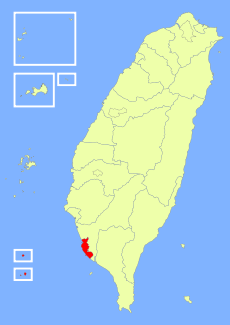
Kaohsiung (traditional Chinese: 高雄; Tongyong Pinyin: Gaosyóng; Hanyu Pinyin: Gāoxióng; Wade-Giles: Kao-hsiung ; Pe̍h-ōe-jī: Ko-hiông; old names: Takao, Takow, Takau) is a city located in southwestern Taiwan. It is enclosed by the Kaohsiung County, and faces the Taiwan Strait on the west. As one of two Direct-controlled municipalities under the administration of Republic of China (ROC), Kaohsiung is officially named as the Kaohsiung City, a province-level political division. It is divided into eleven districts, each with an office.
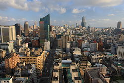
Kaohsiung is the most dense and the second largest city in Taiwan, with a population around 1.51 million.[1] It acts as a center for manufacturing, refining, shipbuilding, and some other light or heavy industries. A major port which through most of marine imports and exports of Taiwan, is located at the city, but is not managed by the city government. An international airport, the terminal of Sun Yat-sen Freeway, and the railway stations of Western Line and Taiwan High Speed Rail, are also located in Kaohsiung. The city is also a home to the Republic of China Navy, which is based in its naval ports.
The Kaohsiung Mass Rapid Transit, a subway system of the city, had been launched in early 2008. Kaohsiung will be the host of the 2009 World Games, a multisport event primarily composed of sports not featured in the Olympic Games.
Contents |
History
Founded near the end of the Ming Dynasty in the 17th century, the village was known as Takau (Chinese: 打狗; pinyin: Dǎgǒu; POJ: Táⁿ-káu) in the Hoklo language spoken by most of the early immigrants. The name originates from the Makatao language of the local aboriginal tribe and translates as "bamboo forest". The Dutch established Fort Zeelandia in 1624 and defeated the local tribes in 1635. They called the place Tancoia. The Dutch were later expelled by the Kingdom of Tungning government founded by Ming Dynasty loyalists of Koxinga in 1662. Zheng Jing, the son of Koxinga, renamed the village Wan-nien-chow (traditional Chinese: 萬年州; simplified Chinese: 万年洲; pinyin: Wǎn Nián Zhōu) in 1664. The name was restored to Takau in the late 1670s, when the town expanded dramatically with immigrants from mainland China. In 1684 the Qing Dynasty annexed Taiwan and renamed the town Fengshan County (traditional Chinese: 鳳山縣; simplified Chinese: 凤山县; pinyin: Fèngshān xiàn), considering it a part of Taiwan Prefecture. It was first opened as a port during the 1680s.
In 1895, Taiwan was ceded to Japan as part of the Treaty of Shimonoseki. It was during this period that the city's name was changed from 打狗 (Taiwanese: Táⁿ-káu) to 高雄 (romaji: Takao). While the sound remained more or less the same, the literal meaning of the name changed from "Beating Dog" to "High Hero". The Japanese developed Takao, especially the harbour. An important military base and industry center, the city was heavily bombed by Task Force 38 and FEAF during 1944-1945.
After control of Taiwan was handed to the Republic of China in 1945, the official romanization of the city name came to be "Kao-hsiung", based on the Wade-Giles romanization of the Standard Mandarin reading of the kanji name. Kaohsiung was upgraded to a municipality on July 1, 1979, by the Executive Yuan, which approved this proposal on November 19, 1978. The Kaohsiung Incident took place in Kaohsiung on December 10, 1979.
Geography

Kaohsiung is located south of the Tropic of Cancer. The climate is tropical with average temperatures ranging from between 18.6 and 28.7 degrees Celsius, and average humidity between 60 and 81%. Average annual rainfall is 1134 mm.
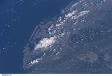
The city sits on the southwestern coast of Taiwan facing the Taiwan Strait. The downtown areas are centered around Kaohsiung Harbor with the island of Chijin on the other side of the harbor acting as a natural breakwater. The Love River (or Ai River) flows into the harbor through the Old City and downtown. Zuoying Military Harbor lies to the north of Kaohsiung Harbor and the city center. Kaohsiung's natural landmarks include the coral mountains Ape Hill, Shoushan and Banpingshan.
Government
Politics

- See also: Republic of China municipal elections, 2006 and List of mayors of Kaohsiung
Kaohsiung is sometimes seen as the political mirror image of Taipei. While northern Taiwan leans towards the Pan-Blue Coalition in the state-level elections, southern Taiwan leaned towards the Pan-Green Coalition since late 1990s, and Kaohsiung is no exception. Frank Hsieh of the Democratic Progressive Party was reelected twice as Mayor of Kaohsiung, where he was widely credited for transforming the city from an industrial sprawl into an attractive modern metropolis. Hsieh resigned from the office of mayor to take up the office of Premier of the Republic of China in 2005. The last municipal election, held on December 9, 2006, resulted in a victory for the Democratic Progressive Party's candidate Chen Chu, the first elected female mayor of direct-controlled municipalities in Taiwan, defeating her Kuomintang rival and former deputy mayor, Huang Chun-ying.
Subdivisions
Kaohsiung is divided into 11 administrative districts:
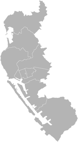
2.Cianjin
3.Sinsing
4.Cijin


| Tongyong Pinyin | Chinese character (Hanzi) | Wade-Giles | Hanyu Pinyin | |
|---|---|---|---|---|
| Traditional | Simplified | |||
| The Old City | ||||
| Cijin District | 旗津區 | 旗津区 | Ch`i-chin Ch'ü | Qíjīn Qū |
| Gushan District | 鼓山區 | 鼓山区 | Ku-shan Ch'ü | Gǔshān Qū |
| Yancheng District | 鹽埕區 | 盐埕区 | Yan-ch`eng Ch'ü | Yánchéng Qū |
| Zuoying District | 左營區 | 左营区 | Tso-ying Ch'ü | Zuǒyíng Qū |
| Downtown | ||||
| Sinsing District | 新興區 | 新兴区 | Hsin-hsing Ch'ü | Xīnxīng Qū |
| Cianjin District | 前金區 | 前金区 | Ch`ien-chin Ch'ü | Qiánjīn Qū |
| Lingya District | 苓雅區 | 苓雅区 | Ling-ya Ch'ü | Língyǎ Qū |
| Sanmin District | 三民區 | 三民区 | San-min Ch'ü | Sānmín Qū |
| Outer Districts | ||||
| Nanzih District | 楠梓區 | 楠梓区 | Nan-tzu Ch'ü | Nánzǐ Qū |
| Cianjhen District | 前鎮區 | 前镇区 | Ch`ien-chen Ch'ü | Qiánzhèn Qū |
| Siaogang District | 小港區 | 小港区 | Hsiao-kang Ch'ü | Xiǎogǎng Qū |
Two islands in the South China Sea are administered by Kaohsiung City as parts of Cijin District:
- Taiping (island) (traditional Chinese: 太平島; simplified Chinese: 太平岛; pinyin: Tàipíng dǎo)
- Dongsha Islands or Pratas Islands (traditional Chinese: 東沙群島; simplified Chinese: 东沙群岛; pinyin: Dōngshā Qúndǎo)
Economy
Intensive settlement began in earnest in the late 17th century, when the place was known as Ch'i-hou. Opened in 1863 as a treaty port, subsidiary to the port of Anping farther north on the coast, Kaohsiung became a customs station in 1864 and then gradually became an important port for the southern Taiwan coastal plain.
Kaohsiung's real economic and strategic importance began under the Japanese occupation (1895–1945). The Japanese needed a good port in southern Taiwan to serve those designated areas that were to become a major source of raw materials and food for Japan, and Kaohsiung was chosen. It became the southern terminus of the main north-south railway line, and from 1904 to 1907 extensive harbor works were undertaken. In 1920 the port was given the name Takao and the area became a municipality in 1920.
Before and during World War II it handled a growing share of Taiwan's agricultural exports to Japan, and was also a major base for Japan's campaigns in Southeast Asia and the Pacific, and extremely ambitious plans for the construction of a massive modern port were drawn up. At the same time, it handled a growing share of Taiwan's agricultural exports to Japan. Toward the end of the war, too, the Japanese promoted some industrial development at Kaohsiung, establishing an aluminum industry based on the abundant hydroelectric power produced by the Jih-Yueh Lake project in the mountains.
After it came under Chinese administration in 1945, Kaohsiung developed rapidly. The port, badly damaged in World War II, was restored. It also became a fishing port for boats sailing to Philippine and Indonesian waters. Largely because of its climate, Kaohsiung has overtaken Keelung as Taiwan's major port.
Today as a major international port and industrial city in the southwest of the country, Kaohsiung is the most rapidly developing urban center of Taiwan. With an area of 154 km2, it has a large natural harbor, with the entrance in recent years being expanded, rock-excavated, and dredged.
As an exporting center, Kaohsiung serves the rich agricultural interior of southern Taiwan, as well as the mountains of the southeast. Major raw material exports include rice, sugar, bananas, pineapples, peanuts (groundnuts), and citrus fruits. The 2,200 hectare Linhai Industrial Park, on the waterfront, was completed in the mid-1970s and includes a steel mill, shipyard, petrochemical complex, and other industries. The city has a petroleum refinery, aluminum and cement works, fertilizer factories, sugar refineries, brick and tile works, and salt-manufacturing and papermaking plants. Designated an export-processing zone in the late 1970s, Kaohsiung has succeeded in attracting foreign investment to process locally purchased raw materials for export. There is also a large canning industry that processes both fruit and fish.
Transportation
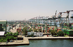
Port of Kaohsiung
Also known as the "Harbor Capital" of Taiwan, Kaohsiung has always had a strong link with the ocean and maritime transportation. Ferries play a key role in everyday transportation, and often play the role that buses do in other cities, especially for transportation across the harbor. With five terminals and 23 berths, the Port of Kaohsiung is Taiwan's largest container port and the 6th largest in the world.[2] In 2007 the port reached its handling capacity with a record trade volume of 10.2 million twenty-foot equivalent units (TEU).[3] A new container terminal is under construction, increasing future handling capacity by 2 million TEU by 2013.[3]
The Port of Kaohsiung is not officially a part of Kaohsiung City, instead it is administrated by Kaohsiung Port Authority, under Ministry of Transportation. There is a push for Kaohsiung City to annex the Port of Kaohsiung in order to facilitate better regional planning.
Kaohsiung International Airport
Kaohsiung City is also home to Taiwan's second largest airport, the Kaohsiung International Airport, which is located in the Siaogang District in southern Kaohsiung City.
Rapid Transit

A new metro system, the Kaohsiung Rapid Transit System opened for revenue service in March 2008. A light rail line that circles central Kaohsiung City was also approved in 2007. In 2004, the Kaohsiung City Government and Siemens AG built a temporary two-station circular light rail line, along with one trainset, in Central Park, in order to demonstrate the feasibility of building a light rail system in Kaohsiung City. It was meant to alleviate some residents' concerns, such as producing excessive noise and hindering normal traffic flow, that light rail would negatively impact their surroundings. This Siemens Combino vehicle was later used as part of the defunct M>Tram network in Melbourne, later transferring to Yarra Trams.
Railroad
The city is served by the Taiwan Railway Administration's Western Line and Pingtung Line. Taiwan High Speed Rail also serves Kaohsiung City via its new Zuoying Station in northern Kaohsiung City. Future plans include extending high speed rail to the new Kaohsiung Station in the city center. The new Kaohsiung Station will be an underground station, replacing the current surface station. Additionally, these two stations will also be served by Red line of Kaohsiung Rapid Transit System when the line opened for revenue service in early 2008. s
Attractions

- Love River (愛河)
- Urban Spotlight Arcade (城市光廊)
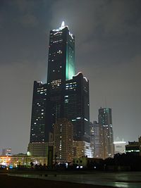
- Tuntex Sky Tower (東帝士85國際廣場)
- Liouho Night Market (六合夜市)
- Zuoying's Lotus Lake (左營蓮池潭)
- Kaohsiung Museum of Fine Arts (高雄市立美術館)
- Chihou Battery (旗後砲台)
- Cijin Ferry (旗津渡輪)
- Fengshan Old City (鳳山舊城)
- Chai Mountain (柴山)
- Bang Ping Mountain (半屏山)
- Shou Shan Zoo (壽山動物園)
- Former British Consulate at Takao (前清英國領事館)
- Holy Rosary Cathedral (前金天主堂)
- National Science and Technology Museum (國立科學工藝博物館)
- Kaohsiung Museum of History (高雄市立歷史博物館)
- Old Kaohsiung Railway Station (台鐵舊高雄車站)
- Sizihwan Scenic Area (西子灣風景區)
- Kaohsiung Astronomical Museum (高雄市立天文教育館)
- Kaohsiung Hakka Cultural Museum (高雄市客家文物館)
- Chang-Gu World Trade Center (長谷世貿大樓)
- Tower of Light (光之塔)
- Singuang Ferry Wharf (新光碼頭)
- True Love Ferry Pier (真愛碼頭)
- Kaohsiung Fisherman's Wharf (高雄港漁人碼頭)
- Hsinshing Night Market
Education

Kaohsiung has a number of colleges and junior colleges offering training in commerce, education, maritime technology, medicine, modern languages, nursing, and technology.
- Kaohsiung Medical University (高雄醫學大學)
- National Sun Yat-sen University (國立中山大學)
- National Kaohsiung First University of Science and Technology (國立高雄科技大學)
- National Kaohsiung Normal University (國立高雄師範大學)
- National Kaohsiung University of Applied Sciences (國立高雄應用科技大學)
- National University of Kaohsiung (國立高雄大學)
- National Kaohsiung Marine University (國立高雄海洋科技大學)
- National Kaohsiung Hospitality College (國立高雄餐旅學院)
- Municipal Kaohsiung Senior High School (高雄市立高雄高級中學)
- Municipal Kaohsiung Girls' Senior High School (高雄市立女子高級中學)
- Kaohsiung American School (美國學校)
- Wenzao Ursuline College of Languages (文藻外語學院)
Sister cities

 Honolulu, United States
- Macon, United States
- Tulsa, United States
- Colorado Springs, United States
- Miami, United States
- San Antonio, United States
- Seattle, United States
- Knoxville, United States
- Plains, United States
- Pensacola, United States
- Mobile, United States
- Little Rock, United States
- Portland, United States
 Busan, South Korea
 Cebu, Philippines
 Danang, Vietnam
 Barranquilla, Colombia
 Cartago, Costa Rica
 Durban, South Africa
 Blantyre, Malawi
 Brisbane, Australia
See also
- Taipei City
- List of cities in the Republic of China (Taiwan)
- Administrative divisions of the Republic of China
References
- ↑ Welcome to Kaohsiung City - Statistics
- ↑ Review of Maritime Transport 2004. New York: United Nations. 2005. ISBN 92-1-112645-2.
- ↑ 3.0 3.1 Dale, Jamie (2008-01=17). "Kaohsiung container port hits full capacity", Lloyd's List Daily Commercial News, Informa Australia, pp. 16.
External links
- Kaohsiung travel guide from Wikitravel
- Kaohsiung City Government Official Website (Chinese) (English)
|
||||||||||||||||||||||
|
|||||||||||||

|
||||||||||||||||||||||||