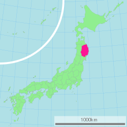
Iwate Prefecture
| Iwate Prefecture | |||||||||
|
|||||||||
 |
|||||||||
| Capital | Morioka | ||||||||
| Region | Tohoku | ||||||||
| Island | Honshū | ||||||||
| Governor | Takuya Tasso | ||||||||
| Area (rank) | 15,278.40 km² (2nd) | ||||||||
| - % water | 0.1% | ||||||||
| Population (November 1, 2006) | |||||||||
| - Population | 1,374,530 (30th) | ||||||||
| - Density | 90 /km² | ||||||||
| Districts | 11 | ||||||||
| Municipalities | 36 | ||||||||
| ISO 3166-2 | JP-03 | ||||||||
| Website | www.pref.iwate.jp/english/ | ||||||||
| Prefectural Symbols | |||||||||
| - Flower | Paulownia tree (Paulownia tomentosa) | ||||||||
| - Tree | Nanbu red pine (Pinus densiflora) | ||||||||
| - Bird | Green pheasant (Phasianus colchicus) | ||||||||
Symbol of Iwate Prefecture |
|||||||||
| Template ■ Discussion ■ Parameter ■ WikiProject Japan | |||||||||
Iwate Prefecture (岩手県 Iwate-ken?) is a prefecture of Japan located in the Tōhoku region on Honshū island. The capital is Morioka.
Contents |
History
Iwate was historically part of Mutsu Province. It was brought into the empire around 800.
In the Jōmon period it was an area abundant in fishing and hunting. There were also Emishi settlements in the Kitakami Basin until the end of the eighth century when the Nara authorities penetrated deeply into Iwate, with Fort Shiwa, to the north of present day Morioka, constructed in 803.
Iwate was struck by a 7.2 magnitude earthquake on June 14, 2008.
Geography

Iwate faces the Pacific Ocean to the east, and borders Aomori Prefecture on the north, Akita Prefecture on the west, and Miyagi Prefecture on the south. The prefecture has mountains in the west, north and east, with the valley of the Kitakami River running from north to south through the center of the province and including the capital. The coast is very rugged, with little in between the mountains and the sea.
Cities
Thirteen cities are located in Iwate Prefecture:
|
|
Towns and villages
Towns and villages in each district:
|
|
|
Mergers
Economy
Iwate's industry is concentrated around Morioka and specializes in semiconductor and communications manufacturing.
Demographics
Culture
Of the several theories about the origin of the name ‘Iwate’, the most well known tale, 'Oni no tegata,' is that associated with Mitsuishi Shrine in Morioka. (The Mitsuishi, literally ‘three rocks’, are said to have been thrown down into Morioka by an eruption of Mt Iwate.) According to the legend, there was once a devil who often tormented and harassed the local people. When the people prayed to the spirits of Mitsuishi for protection, the devil was immediately shackled to the rocks and made to promise never to trouble the people again. As a sign of this promise the devil left a handprint on one of the rocks, thus giving rise to the name Iwate, literally meaning ‘rock hand’. Even now after a rainfall it is said that the devil’s hand print can still be seen.
Poet and author Kenji Miyazawa was born in Iwate and lived much of his life there.
Bashō
Bashō visited and wrote about Iwate in the journey described in Oku no Hosomichi. Hiraizumi in particular inspired him.
Tourism
|
|
Prefectural symbols
| Bird | Pheasant |
| Flower | |
| Tree | Nambu Red Pine |
| Fish | Nambu Salmon |
References
- (Japanese) Japanese Wikipedia
- Yiengpruksawan, M.H. Hiraizumi: Buddhist Art and Regional Politics in Twelfth Century Japan, Harvard University Asia Center, Cambridge MA, 1998
External links
- (English) Official Iwate Prefecture homepage
|
|||
| Cities | |||
|---|---|---|---|
| Hachimantai | Hanamaki | Ichinoseki | Kamaishi | Kitakami | Kuji | Miyako | Morioka (capital) | Ninohe | Ōfunato | Ōshū | Rikuzentakata | Tōno | |||
| Districts | |||
| Higashiiwai | Isawa | Iwate | Kamihei | Kesen | Kunohe | Ninohe | Nishiiwai | Shimohei | Shiwa | Waga | |||
|
|
|||||||||||