Ithaca
- Ithaka redirects here. For musician/poet Ithaka Darin Pappas see Ithaka (musician)
| Ithaca Ιθάκη |
|
|---|---|
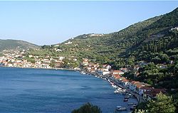 Vathi, South Ithaca |
|
| Geography | |
 |
|
| Island Chain: | Ionian Islands |
| Area:[1] | 117.812 km² (45 sq.mi.) |
| Highest Mountain: | Nirito (806 m (2,644 ft)) |
| Government | |
| Periphery: | Ionian Islands |
| Prefecture: | Kefalonia and Ithaka |
| Capital: | Itháki, Ithaca |
| Statistics | |
| Population: | 3,084 (as of 2001) |
| Density: | 26 /km² (68 /sq.mi.) |
| Postal Code: | 283 00, 283 01 |
| Area Code: | 26740 |
| License Code: | KE |
| Website | |
| www.ithaki.gr | |
Ithaca or Ithaka (in Greek, Ιθάκη, Ithaki) is an island in the Ionian Sea, in Greece, with an area of 118 km² (45 sq. miles) and three thousand inhabitants. It is an independent municipality of the prefecture of Kefalonia and Ithaka, and lies off the northeast coast of Kefalonia. The municipality of Ithaca includes some smaller islands as well. The capital, Itháki (Vathý), has one of the world's largest natural harbors.
Contents |
Origin of Name
There are various interpretations as to the origin the name Ithaca, it is believed that it comes from:
- Ithacos, the hero from mythology;
- the Greek word "ithy" which means "cheerful;"
- the Greek adjective "ithys" which means "straight" (or, metaphorically, just or true)[2]
- the Phoenician word "utica" which means "colony."
The name Ithaca has remained unchanged since ancient times, but it has been noticed that in written documents of different periods, it has also been referred to by other names such as:
- Nerikii (7th century BC);
- Val di Compare (Valley of the Bestman), Piccola (Small) Cephallonia, Anticephallonia (Middle Ages till the beginning of the Venetian period);
- Ithaki nisos (island), Thrakoniso, Thakou, Thiakou (Byzantine period);
- Fiaki (Turkish period);
- Teaki (Venetian period); and
- Thiaki (before the Venetian period, also called so by the sailors and has remained the name used by the inhabitants).
History
The origin of the first people to inhabit the island, which was during the last years of the Neolithic Period (4000-3000 BC), is unknown. The traces of buildings, walls and a road from this time period prove that life existed and continued to do so during the Early Hellenic era (3000-2000 BC). In the years (2000-1500 BC), some of the population migrated to part of the island. The buildings and walls that were excavated showed the lifestyle of this period had remained primitive.
Mycenaean Era
- Further information: Mycenaean Greece
During the Mycenaean period (1500-1100 BC), Ithaca rose to the highest level of its ancient history. The island became the capital of the Cephalonian states, which included the surrounding lands, and was referred to as one of the most powerful states of that time. The Ithacans were characterized as great navigators and explorers with daring expeditions reaching further than the Mediterranean Sea.
The epic poems of Homer, the Iliad and the Odyssey, may shed some light on Bronze-Age Ithaca. Those poems are generally thought to have been composed sometime within the 8th to 6th centuries BC, but are based on older mythological and poetic traditions; their depiction of the hero Odysseus, and his rule over Ithaca and the surrounding islands and mainland, may preserve some memories of the political geography of the time.
After the end of the Mycenaean period, Ithaca's influence diminished, and it came under the jurisdiction of the nearest large island.
Hellenistic Era
- Further information: Hellenistic Greece
During the ancient Hellenic prime (800-180 BC) the Corinthians neglected the small and barren island. Independent organized life continued in the northern and southern part of the island. In the southern part, in the area of Aetos, the town Alalcomenae was founded. From this period, many objects were found during excavations, which were of important historical value. Among these objects were the coins imprinted with the name Ithaca and the image of Odysseus and that it was self-governed.
According to the different periods, the conquerors and the circumstances, the population of the island kept changing. Although there is not definite numerical information until the Venetian period, it is believed that from the Mycenaean to the Byzantine period the number of inhabitants was several thousand, who lived mainly at the northern part of the island. During the Middle Ages, the population decreased due to the continuous invasions of the pirates, which forced the people to live on the mountains establishing settlements.
Ottoman Era
- Further information: Ottoman Greece
In 1479, Turkish forces reached the islands and many of the people fled from the island out of fear of the Turkish occupiers. Those that remained hid in the mountains to avoid the pirates who controlled the channel between Cephallonia and Ithaca and the bays of the island. In the following five years, the Turks, Toques and Venetians laid claim to the islands diplomatically. Possession of the islands was finally given to the Turkish Empire from 1484 to 1499. During this time, the Venetians had strengthened into a major power with an organized fleet. The Venetians pursued their interest in the Ionian Islands, and in 1499 a war between the Venetians and the Turks started. The allied fleets of the Venetians and the Spanish besieged Ithaca, and the other islands. The fleets prevailed, and from 1500 the Venetians controlled the islands. According to a treaty of 1503, Ithaca, Cephallonia and Zante belonged to the Venetians, and Lefkada to the Turks.
French Era

A few years after the French Revolution, the Ionian area came under the rule of the First French Republic (1797-1798), and the island became the honorary capital of Cephallonia, Lefkada, and part of the Greek mainland, which formed the French départment of Ithaque (the prefecture was at Argostoli on Kefalonia).
The population welcomed the French, who took care in the control of the administrative and judicial systems, but later the heavy taxation they demanded, caused a feeling of indignation among the people. During this short historical period, the new ideas of system and social structure greatly influenced the inhabitants of the island. At the end of 1798, the French were succeeded by Russia and Turkey (1798-1807), which were allies at that time. Corfu became the capital of the Ionian States, and the form of government was democratic with a fourteen-member senate in which Ithaca had one representative.
The Ithacan fleet flourished when it was allowed to carry cargo up to the ports of the Black Sea. In 1807, according to an agreement with Turkey the Ionian Islands once again came under the French rule (1807-1809 AD). The French quickly began preparing to face the English fleet, which had become very powerful, by building a fort in Vathy.
Prominent citizens of Ithaki participated in the secret "Filiki Etairia" which was instrumental in organizing the Greek Revolution of 1821 against Turkish rule, and Greek fighters found refuge there. In addition, the participation of Ithacans during the siege of Messologi and the naval battles with Turkish ships at the Black Sea and Danube were significant.
To summarize, the island has been inhabited since the 2nd millennium BC. It was the capital of Cephalonia during the Mycenaean period. The Romans occupied the island in the 2nd century BC, and later it became part of the Byzantine Empire. The Normans ruled Ithaca in the 12th and 13th century, and after a short Turkish rule it fell into Venetian hands.
Ithaca was then occupied by France under the 1797 Treaty of Campo Formio. It was liberated by a joint Russo-Turkish force in 1798, before becoming part of the Septinsular Republic. It became a French possession again in 1807, until it was liberated by the United Kingdom in 1809. Under the 1815 Treaty of Paris, Ithaca became a state of the United States of the Ionian Islands, an amical protectorate of the United Kingdom. Under the 1864 Treaty of London, Ithaca, along with the islands, were ceded to Greece as a mark of cordiality with Greece's new king, the Anglophile George I.[3]
Modern Ithaca
Many structures were destroyed in an earthquake in 1953. In the 1970s, Kalamos split from the province and became part of the prefecture of Lefkada, and the province of Ithaca became a non-provincial municipality.
Home of Odysseus?

Since antiquity, Ithaca has been identified as the home of the mythological hero Odysseus. In the Odyssey of Homer, Ithaca is described thus (13.21-27)
- "I dwell in shining Ithaca. There is a mountain there,
- high Neriton, covered in forests. Many islands
- lie around it, very close to each other,
- Doulichion, Same, and wooded Zacynthos--
- but low-lying Ithaca is farthest out to sea,
- towards the sunset, and the others are apart, towards the dawn and sun.
- It is rough, but it raises good men."
It has sometimes been argued that this description does not match the topography of modern Ithaca. Three features of the description have been seen as especially problematic. First, Ithaca is described as "low-lying" (χθαμαλὴ), but Ithaca is mountainous. Second, the words "farthest out to sea, towards the sunset" (πανυπερτάτη εἰν ἁλὶ ... πρὸς ζόφον) are usually interpreted to mean that Ithaca must be the island furthest to the west, but Kefalonia lies to the west of Ithaca. Lastly, it is unclear which modern islands correspond to Homer's Doulichion and Same.
The Greek geographer Strabo, writing in the 1st century AD, identified Homer's Ithaca with modern Ithaca. Following earlier commentators, he interpreted the word translated above as "low-lying" to mean "close to the mainland", and the phrase translated as "farthest out to sea, towards the sunset" as meaning "farthest of all towards the north." Strabo identified Same as modern Kefalonia, and believed that Homer's Doulichion was one of the islands now known as the Echinades. Ithaca lies farther north than Kefalonia, Zacynthos, and the island that Strabo identified as Doulichion, consistent with the interpretation of Ithaca as being "farthest of all towards the north."
Strabo's explanation has not won universal acceptance. In the last few centuries, some scholars have argued that Homer's Ithaca was not modern Ithaca, but a different island. Perhaps the best known proposal is that of Wilhelm Dörpfeld, who believed that the nearby island of Leukas was Homer's Ithaca.[4]
It has also been suggested that Paliki, the western peninsula of Kefalonia, is Homer's Ithaca. This identification has been proposed several times; in a recent book, Odysseus Unbound, Robert Bittlestone argues that at the time the Odyssey was composed, Paliki was an island, separated from Kefalonia by a narrow channel. One of the main points of the book attempts to suggest that Ithaki has no sunset views. However, the northern part of Ithaki has a much higher elevation than Kefalonia; and it is flatter than the other Ionian Islands.
Despite any difficulties with Homer's description of the island, in classical and Roman times the island now called "Ithaca" was universally held to be the home of Odysseus; the Hellenistic identifications of Homeric sites, such as the identifications of Lipari as the island of Aeolus, are usually taken with a grain of salt, and attributed to the ancient tourist trade.
The island has been known as Ithaca from an early date, as coins and inscriptions show. Coins from Ithaca frequently portray Odysseus, and an inscription from the 3rd century BC refers to a local hero-shrine of Odysseus and games called the Odysseia.[5] The Archaeological site of "School of Homer" on modern Ithaca is the only place between Lefkas-Kefalonia-Ithaca Triangle where Linear B has been found, commonly near royal facilities. Modern scholars generally accept the identification of modern Ithaca with Homeric Ithaca, and explain discrepancies between the Odyssey's description and the actual topography as the product of lack of first-hand knowledge of the island, or as poetic license.
Geography

There is also a strait situated in the western part of the island called the Strait of Ithaca. The capes in the island include Exogi, the westernmost but not in land, Melissa to the north, Mavronos and Agios Ilias to the east, Schinous, Sarakiniko and Agios Ioannis, the easternmost to the east and Agiou Andreou, the southernmost in the south. Bays include Afales Bay to the northwest, Frikes and Kioni Bays to the northeast and Ormos Gulf and Sarakiniko Bay to the southeast. The tallest mountain is Nirito (806 m), the second tallest is Merovigli (669 m).
Lazaretto Islet (or Island of The Saviour) guards the harbor. The church of The Saviour and the remains of an old gaol sit on the island.[6]
Notable people
- Odysseas Androutsos (1788-1825), hero of the Greek War of Independence
- Lorentzos Mavilis (1860 - November 28 1912 in the Ioannina area)
- Marino Lucas (1869-1931), Greek-Australian businessman
- Ioannis Metaxas (1871–1941), general and dictator of Greece
- Anthony JJ Lucas (1862-1946), Greek-Australian businessman
Municipality
The municipality includes islands other than Ithaca including two near Cape Melissa, Arkoudi and Atokos to the northeast and the numerous islands in the Echinades Islands group (the larger ones being Drakonera, Makri, Oxeia, Petalas, and Vromonas) to the east near the mainland of Aitoloakarnania. Its largest towns are Itháki (pop. 1,816), Perachóri (354), Stavrós (325), Platreithiá (210), and Kióni (171).
Communities and villages

- Aetos
- Afales
- Agios Ioannis
- Agia Saranta
- Anogi
- Exogi
- Frikes
- Kalivia
- Kathara
- Kioni
- Kolieri
- Lachos
- Lefki
- Marmaka
- Perachori
- Piso Aetos
- Platrithia
- Rachi
- Stavros
- Vathy (Itháki)
Further reading
- Bittlestone, Robert; James Diggle and John Underhill (2005). Odysseus Unbound: The Search for Homer’s Ithaca. Cambridge, UK: Cambridge University Press. ISBN 0-521-85357-5.
- Tzakos, Christos I.. Ithaca and Homer: The Truth, The Advocacy of the Case. Translator: Geoffrey Cox. http://www.arsenis.info/Ithaca_and_Homer/Ithaca_and_Homer.html.
See also
- List of traditional Greek place names
References
- ↑ "Basic Characteristics". Ministry of the Interior. www.ypes.gr. Retrieved on 2007-08-07.
- ↑ Liddell and Scott
- ↑ "Ionian Islands" (history), Encyclopaedia Britannica, 1911 Edition.
- ↑ Wilhelm Dörpfeld, Alt-Ithaka (1927).
- ↑ Frank H. Stubbings, "Ithaca", in Wace and Stubbings, eds., A Companion to Homer (New York 1962).
- ↑ http://www.igougo.com/travelcontent/journalEntryOverview.aspx?EntryID=48274
External links
- Official website (Greek)
- Ithaki Metasearch (Powerful search engine named in honour of Ithaka)
|
|||||
|
||||||||