Invercargill
| Invercargill Waihōpai (Māori) |
|
 |
|
 |
|
| Country | |
|---|---|
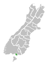
| Island | South Island |
| Region | Southland |
| Territorial authority | Invercargill City |
| Government | |
| - Mayor | Tim Shadbolt |
| - Deputy Mayor | Neil Boniface |
| Area | |
| - Territorial | 491 km² (189.6 sq mi) |
| Population (June 2008 estimate)[1] | |
| - Territorial | 51,600 |
| - Density | 105.1/km² (272.2/sq mi) |
| - Urban | 48,000 |
| Time zone | NZST (UTC+12) |
| - Summer (DST) | NZDT (UTC+13) |
| Postcode(s) | 9810, 9812 |
| Area code(s) | 03 |
| Website: http://www.icc.govt.nz/ | |
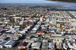
Invercargill (Waihōpai in Māori) is the southernmost and westernmost city in New Zealand, and one of the southernmost cities in the world. It is the commercial centre of the Southland region. It lies in the heart of the wide expanse of the Southland Plains on the Oreti or New River some 18 km north of Bluff, which is the southernmost town in the South Island. It sits amid rich farmland that is bordered by large areas of conservation land and marine reserves, including Fiordland National Park covering the south-west corner of the South Island.
Invercargill is home to some of New Zealand's best sporting facilities including the only indoor cycling velodrome in the country. The indoor 250m wooden velodrome is home to Track Cycling in Southland and is currently the fastest track in the country. The Invercargill Licensing Trust supports the Velodrome which is situated at Stadium Southland an enormous indoor sports stadium located at Surrey Park. Invercargill also has one of the fastest Olympic sized swimming pools in Australasia , a regular feature on the world swimming circuit.
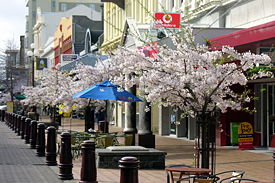
Many streets in the city, especially in the centre and main shopping district, are named after rivers in the United Kingdom, mainly Scotland. These include the main streets Dee and Tay, plus those named after the Tyne, Esk, Don, Thames, Mersey, Ness, Yarrow, Spey, Tay, and Eye rivers.
Contents |
Transport
Road
Invercargill is the southernmost city on New Zealand's state highway network and is linked to Fiordland and the Catlins by the Southern Scenic Route.
- See also: Public transport in Invercargill
Rail links
Invercargill is at the southern end of the Main South Line railway, which extends up the east coast to Christchurch and Lyttelton via Dunedin. Until the cancellation of The Southerner in 2002, Invercargill had the southernmost passenger railway station in the world. Passenger trains no longer call at Invercargill, except for occasional excursions. The Bluff Branch extends south from Invercargill and has been freight-only since 1967. The Wairio Branch extends northwest from Invercargill to the Solid Energy coalfields near Ohai and continues to carry freight. Invercargill was once the centre of a much larger rail network, but over the years, since retrenched.
Airport
During the mid 1950s, Invercargill Airport was used for fuel top-up and final take off by Operation Deep Freeze. Twin-engine propeller-driven planes destined for McMurdo Sound in the Antarctic used the airport, assisted in takeoff by JATO rockets under their wings. Bigger aircraft flew from Christchurch where Deep Freeze had a base.
Invercargill Airport's primary commercial traffic currently comprises Mount Cook Airline, and Air Nelson which are wholly owned subsidiaries of Air New Zealand, with ATR 72 aircraft flying to Christchurch, and Bombardier Q300 aircraft flying to Wellington respectively and regular flights to and from Stewart Island/Rakiura.
Invercargill airport's runway is 2200 meters long and the heaviest aircraft to land there is the Boeing Globemaster III of the USAF. The most modern type now used on Operation Deep Freeze service.
History
Southland was a scene of early extended contact between Europeans and Maori, in this case sealers and whalers and missionaries - Wohlers at Ruapuke. From 1848, Otago, of which Southland was itself part, was the subject of planned settlement by the Free Church, an offshoot of the Presbyterian Church of Scotland. Settlement broadened with the discovery of gold in Central Otago in the 1860s.
Even today, traces of Scottish speech persist in Southland voices, with R often pronounced with a rolling burr. This is more noticeable in country people.
In 1856, a petition was put forward to Thomas Gore Browne, the Governor of New Zealand, for a port at Bluff. Browne agreed to the petition and gave the name Invercargill to the settlement north of the port. Inver comes from the Scots Gaelic word inbhir meaning a river's mouth and Cargill is in honour of Captain William Cargill, who was at the time the Superintendent of Otago, of which Southland was then a part.
From 1861 to 1870, Invercargill was the centre of Southland Province, which separated from Otago Province, but later rejoined it.
In December 1905, Invercargill voted in local prohibition of alcohol sales. This lasted for 40 years until voted out by returning servicemen in World War II. Drinking continued meanwhile, thanks to huge volumes of beer, often in kegs, brought to private homes, or sold by the glass by keggers at hiding spots round the City. When prohibition ended, a committee of citizens persuaded the Government to give the monopoly on liquor sales in Invercargill to the specially formed Invercargill Licensing Trust. Based on a scheme in Carlisle, England, it returns profits to city amenities. Even today, alcohol is not sold in supermarkets.
In recent years, publicity has been brought to the southern city by the election of Tim Shadbolt, a colourful and outspoken former student activist, as mayor. He once appeared on a cheese ad stating "I don't mind where, as long as I'm Mayor". His supporters like the colour he brings to the city. His opponents refer to his controversial mayoral career in the Auckland suburbs and to his attitude to veterans during his opposition to the Vietnam War.
Economy
Invercargill is home to the Southern Institute of Technology, which has introduced a free-fees scheme. The scheme was partly responsible for rejuvenating the city when it was in a steady state of population decline. However the major factor in Invercargill's regrowth is the Dairy and Milk Solids industrial boom of the first decade of the 21st century. New dairy factories have opened around the province of Southland, as well as more efficient meat processing works and research and development facilities.
Climate
Invercargill has a temperate oceanic climate similar to that of the British Isles. The mean daily temperature ranges from 5.2°C in July to 14°C in January. The yearly mean temperature is 9.9°C. Rainfall averages 1112 mm annually, and measurable snowfall is occasionally seen during the winter months of June to September. It is the cloudiest centre of New Zealand with 1580 hours of sunshine per annum.
The average temperature high ranges from 18.8°C in February to 11°C in August. Owing to its relatively high latitude (46° 42'), the city enjoys nearly 16 hours of daylight at the summer solstice in late December.
Invercargill is "The City of Water and Light". This refers to the long summer twilights and the aurora australis (southern lights). The water reference, humorists suggest, comes from notorious horizontal, driving rain in high wind at the corner of the two main streets, Dee and Tay. A recent sign also states "Invercargill, where dreams can come true" with an image from the 2005 film The World's Fastest Indian.
| Month | Jan | Feb | Mar | Apr | May | Jun | Jul | Aug | Sep | Oct | Nov | Dec | Year |
|---|---|---|---|---|---|---|---|---|---|---|---|---|---|
| Average high °C (°F) | 18.6 (65) |
18.8 (66) |
17.2 (63) |
15 (59) |
12.2 (54) |
9.7 (49) |
9.5 (49) |
11 (52) |
12.9 (55) |
14.4 (58) |
15.8 (60) |
17.5 (64) |
14.4 (58) |
| Average low °C (°F) | 9.4 (49) |
9.1 (48) |
7.7 (46) |
5.8 (42) |
3.7 (39) |
1.5 (35) |
0.9 (34) |
1.9 (35) |
3.7 (39) |
5.5 (42) |
6.8 (44) |
8.4 (47) |
5.4 (42) |
| Precipitation mm (inches) | 114 (4.49) |
79 (3.11) |
94 (3.7) |
100 (3.94) |
114 (4.49) |
99 (3.9) |
88 (3.46) |
71 (2.8) |
80 (3.15) |
95 (3.74) |
81 (3.19) |
100 (3.94) |
1,112 (43.78) |
| Source: NIWA Climate Data[2] 1971 – 2000 | |||||||||||||

The Invercargill March
This internationally famous tune was written by Alex Lithgow who attended Invercargill Grammar School (now Middle School).
In his book 'Invercargill - 150 Years' Lloyd Esler's opening sentence reads ... "Invercargill was done a fine favour by Alex Lithgow who named his famous march after his boyhood home. The Invercargill March is possibly the best advertisement the town has ever had as the work is a brass-band favourite and the word ‘Invercargill’ is whispered amongst audiences worldwide. There is only one Invercargill in the world - this one".
When Invercargill hosted the national Brass band contest in 1909, Alex’s brother Tom asked for a test piece for the contest and Alex offered this piece to the city. On the music he wrote ...
To Invercargill, the Southernmost City in New Zealand (End of the World), and its Citizens, I dedicate this March as a momento of the many pleasant years spent there in my boyhood.
—Alex Lithgow
Education
High schools
All High Schools in Invercargill are Year 7-13, following a Ministry of Education review in 2004 that made most of Invercargill's primary schools Year 1-6 and closed the Year 7-8 schools Rosedale Intermediate and Collingwood Intermediate and Tweedsmuir Junior High
- James Hargest College is in northern Invercargill with about 1800 students.
- Aurora College was established in 2005, after Mount Anglem College was closed in 2004.
- Southland Girls' High School In 2005 became the first state Year 7-13 single-sex female school in New Zealand.
- Southland Boys' High School In 2005 became the first state Year 7-13 single-sex male school in New Zealand.
- Verdon College is a co-educational Catholic school with about 620 students.
Primary Schools
Most primary schools are Year 1-6.
- New River Primary School, co-ed school for Years 1-6 in South Invercargill area. Formerly Kew, South, Clarendon, and Clifton Schools.
- St Joseph's, a small co-ed school for Years 1-6, a Catholic school near St Mary's Basilica.
- St Theresa's, a co-ed Catholic
- St Patrick's, a co-ed Catholic
- Ascot Community School, the only public co-ed school in Hawthorndale area.
- Fernworth Primary - co-ed school in Heidelberg area. Formerly St George and Elston Lea.
- Windsor North School, co-ed school in Rosedale area. Previously Invercargill North School
- Waverley Park School, co-ed school in Waverley Park area.
- Waihopai School, co-ed school in Waihopai area.
- Salford School, co-ed school in Rosedale area.
- St John's Girls' School, small school . Invercargill's only private school. Christian character.
- Sacred Heart Primary School, North Road, Waikiwi. co-ed Special Character Catholic family school serving the northern suburbs of Waikiwi, Grasmere and Makarewa.
- Donovan Primary School, co-ed school Grasmere area. Formerly Grasmere, Waikiwi, West Plains
- Otatara Primary School, co-ed school in Otatara area
- Seventh Day Adventist. A very small co-ed school that follow that particular religion in the Waikiwi area.
Famous Invercargill Notables

- Peter Arnett - NBC war correspondent
- Oliver Bulleid - Railway locomotive designer and Chief Mechanical Engineer of the Southern Railway (Great Britain), born in Invercargill in 1882
- Johnnie Checketts - Silver Star, Wingco and Spitfire Ace
- Bill Crawford-Crompton - Silver Star, Air Vice Marshal and WW2 Commander and Ace
- Marton Csokas - actor
- Dan Davin - author, editor
- Ernest Godward - inventor of the spiral hairpin and the petrol economiser
- Joseph Hatch - businessman, oil factor
- Brigadier James Hargest; CBE, DSO & 2 bars, MC, ED, MP - New Zealand chief military officer for Southland and politician
- Rowena Jackson - Royal Ballet prima ballerina
- Jason Kerrison - Opshop singer /songwriter
- Chris Knox - infamous (in NZ) alternative rock musician
- Alex Lithgow - composer, musician, conductor
- Bill Manhire - inaugural NZ poet laureate
- Herbert James "Burt" Munro - inventor, motorcycle enthusiast, racer and under-1000 cc land speed record holder
- Mils Muliaina - All Black
- Harry Norris - A music director of the D'Oyly Carte Opera Company
- Anton Oliver - All Black
- Herbert Pither - aviation legend of Southland,
- Lesley Rumball - Former Silver Ferns Captain
- Victor Spencer - last soldier to be executed in World War I, pardoned in 2005
- Garfield Todd - Prime Minister of Rhodesia
- Jeremy Waldron - prominent legal and political philosopher
- Joseph Ward - Prime Minister of New Zealand
- Jeff Wilson - All Black and Black Cap ("Double All Black")
Sister Cities
Notes
- ↑ "Subnational Population Estimates: At 30 June 2008". Statistics New Zealand (23 October 2008). Retrieved on 2008-10-28.
- ↑ "Climate Data". NIWA. Retrieved on November 2, 2007.
- ↑ "Sister City". Invercargill City Council.
References
- Reed, A.W. (2002) The Reed dictionary of New Zealand place names. Auckland: Reed Books. ISBN 0-790-00761-4.
External links
- City of Invercargill
- Invercargill City Council
- ICC Map page
- Invercargill Information Center
- Invercargill Street Map
|
|||||||||||||||||