Honshū
| Native name: 本州 | |
 Honshū |
|
| Geography | |
|---|---|
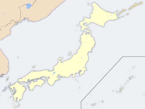 Honshū (Japan)
|
|
| Location | East Asia |
| Archipelago | Japanese Archipelago |
| Area | 230,500 km² (7th) |
| Coastline | 5,450 km (3,390 mi) |
| Highest point | Mount Fuji (3,776 m) |
| Country | |
| Prefectures | Hiroshima, Okayama, Shimane, Tottori, Yamaguchi, Hyōgo, Kyoto, Mie, Nara, Osaka, Shiga, Wakayama, Chiba, Gunma, Ibaraki, Kanagawa, Saitama, Tochigi, Tokyo, Akita, Aomori, Fukushima, Iwate, Miyagi, Yamagata, Aichi |
| Largest city | Tokyo (12,570,000) |
| Demographics | |
| Population | 98,352,000 (as of 1990) |
| Ethnic groups | Japanese |
Honshū (本州? literally "Main State"), or Honshu is the largest island of Japan. The nation's main island, it is south of Hokkaidō across the Tsugaru Strait, north of Shikoku across the Inland Sea, and northeast of Kyūshū across the Kanmon Strait. It is the seventh largest island, and the second most populous island in the world after Java in Indonesia.
The island is roughly 1,300 km long and ranges from 50 to 230 km wide, and its total area is 230,500 km², 61% of the total area of Japan. It is larger than the island of Great Britain, and slightly larger than the state of Minnesota. Honshū has 5,450 km of coastline.
Mountainous and volcanic, Honshū has frequent earthquakes (the Great Kantō earthquake heavily damaged Tokyo in September 1923); the highest peak is the active volcano Mount Fuji at 3,776 m, which makes it the world's 7th highest island. There are many rivers, including the Shinano River, Japan's longest. The climate is temperate, but has marked difference between the eastern or southern (Pacific or Inland Sea coast) side, and the western or northern (Sea of Japan coast) side. A mountain range runs along the length of Honshū from end to end. In addition to Mt. Fuji, the Japanese Alps are features of Honshū.
It has a population of 98,352,000 (as of 1990; in 1975 it was 89,101,702), mostly concentrated in the available lowlands, notably in the Kantō plain where 25% of the total population reside in the Greater Tokyo Area, which includes Tokyo and Yokohama, Kawasaki, Saitama and Chiba cities. Most of the nation's industry is located along the belt running from Tokyo along Honshū's southern coastal cities, including Kyoto, Osaka, Nagoya, Kobe, and Hiroshima.
The economy along the northwestern coast by the Sea of Japan is largely fishing and agriculture[1]; Niigata is noted as an important producer of rice. The Kantō and Nōbi plains produce rice and vegetables. Yamanashi is a major fruit-growing area, and Aomori is famous for its apples.
Eminent historical centers include Kyoto, Nara, and Kamakura.
The island is nominally divided into five regions and contains 34 prefectures, including metropolitan Tokyo. The regions are Chūgoku (western), Kansai (southern, east of Chūgoku), Chūbu (central), Kantō (eastern), and Tōhoku (northern).
The prefectures are:
- Chūgoku region — Hiroshima-ken, Okayama-ken, Shimane-ken, Tottori-ken, Yamaguchi-ken.
- Kansai — Hyōgo-ken, Kyoto-fu, Mie-ken, Nara-ken, Osaka-fu, Shiga-ken, Wakayama-ken.
- Chūbu — Aichi-ken, Fukui-ken, Gifu-ken, Ishikawa-ken, Nagano-ken, Niigata-ken, Toyama-ken, Shizuoka-ken, Yamanashi-ken.
- Kantō — Chiba-ken, Gunma-ken, Ibaraki-ken, Kanagawa-ken, Saitama-ken, Tochigi-ken, Tokyo-to.
- Tōhoku — Akita-ken, Aomori-ken, Fukushima-ken, Iwate-ken, Miyagi-ken, Yamagata-ken.
Honshū is connected to the islands of Hokkaidō, Kyūshū and Shikoku by tunnels or bridges. Three new bridge systems have been built across the islands of the Inland Sea between Honshū and Shikoku (Akashi-Kaikyo Bridge and the Ohnaruto Bridge; Shin-Onomichi Bridge, Innoshima Bridge, Ikuchi Bridge, Tatara Bridge, Ohmishima Bridge, Hakata-Ohshima Bridges, and the Kurushima-Kaikyo Bridge; Shimotsui-Seto Bridge, Hitsuishijima Bridge, Iwakurojima Bridge, Yoshima Bridge, Kita Bisan-Seto Bridge, and the Minami Bisan-Seto Bridge), and the Seikan Tunnel connects Honshū with Hokkaidō.
Events
On July 23, 2008, Honshū was struck by a magnitude 6.8 earthquake.
Extreme points
The northernmost point on Honshū is the tip of the Shimokita Peninsula in Ōma, Aomori. At the southern extreme lies Cape Kure in Kushimoto, Wakayama. The island is bounded on the east by Todogasaki in Miyako, Iwate and on the west by Bishanohana in Shimonoseki, Yamaguchi. It spans more than eight degrees of latitude and 11 degrees of longitude.
References
- ↑ Kodansha Encyclopedia of Japan
|
|||||||||||