Hindu Kush
| Hindu Kush | |
| Range | |
 Mountains of Afghanistan
|
|
| Countries | Afghanistan, Pakistan |
|---|---|
| Region | Northern Areas |
| Part of | Himalaya |
| Highest point | Tirich Mir |
| - elevation | 7,690 m (25,230 ft) |
| - coordinates | |
 |
|
The Hindu Kush is a mountain range located between Afghanistan and Pakistan. The name Hindu Kush derives from the Arabic word meaning "Mountains of India." [1] It is the westernmost extension of the Pamir Mountains, the Karakoram Range, and is a sub-range of the Himalayas. It is also calculated to be the geographic center of population of the world. [2]
Contents |
Nomenclature
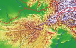
The name Hindu Kush is usually applied to the whole of the range separating the basins of the Kabul, and Helmand rivers from that of the Amu Darya (or ancient Oxus), or more specifically, to that part of the range to the northwest of Kabul.
Sanskrit
Sanskrit documents refer to the Hindu Kush as Pāriyatra Parvat.
Persian
In some of the Iranian languages that are still spoken in the region's many peaks, mountains, and related places in the region have "Kosh" or "Kush" in their names. In the Persian language of the Sassanian period, Hindu referred to the inhabitants of the area around and beyond the Indus River, or Hind - the people who were followers of Hinduism. The name is also said to be a corruption of Hindu Koh, from the (modern) Persian word Kuh, meaning mountain. James Rennell, writing in 1793, referred to the range as the "Hindoo-Kho or Hindoo-Kush"[3].
- "The same hindu- 'mountain' [in Scythian or Saka languages] is in the name Hindǚ-kuš, where the kuš means 'side, region' connected with Chr. Sogd. qwšy 'side' with -ti- Armenian Parthian k'oušt 'side, region' . . . . Old Indian has both koṣa- and kośa-. . . . The legend of Hindukuš meaning 'slaying Hindus' is assigned to an event a hundred years after Bābur's mention of the name." [4]
Ibn Batuta on the term Hindu Kush
| “ | 'Another reason for our halt was fear of the snow. For upon this road there is a mountain called Hindukush, which means 'the slayer of the Indians 'because the slave boys and girls who are brought from the land of India die there in large numbers as a result of the extreme cold and the great quantity of snow ".[5] | ” |
Folk etymology
The origin of the term "Hindu Kush" is a point of contention. There are others who put forward alternate possibilities for its origin, although these are usually considered to be folk etymology :
- a corruption of Caucasus Indicus, a name by which the Hindu Kush range was known in the ancient Western world after its conquest by Alexander the Great in the Fourth Century BC. Greek rule in the Hindu Kush region lasted over three centuries, and was followed by the rule of a dynasty known, significantly, as the Kushan. In its early period, the Kushan Empire had its capital near modern-day Kabul. Later, when the Hindu Kush region became part of the Sassanian Empire, it was ruled by a satrap known as the Kushan-shah (ruler of Kushan).
- a reference to the last great "killer" mountains to cross when moving between the Iranian plateau and the Indian subcontinent, named after the toll it took on anyone crossing them.
- a posited Avestan appellation meaning "water mountains."
- a corruption of Hind-o Kushan, containing the name of the Kushan dynasty that once ruled this region for more than three centuries.
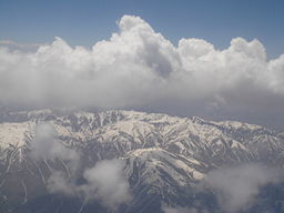
Mountains

The mountains of the Hindu Kush system diminish in height as they stretch westward: toward the middle, near Kabul, they extend from 4,500 to 6,000 meters (14,700 feet to 19,100 feet); in the west, they attain heights of 3,500 to 4,000 meters (11,500 feet to 13,000 feet). The average altitude of the Hindu Kush is 4,500 meters (14,700 feet). The Hindu Kush system stretches about 966 kilometres (600 miles) laterally, and its median north-south measurement is about 240 kilometres (150 miles). Only about 600 kilometres (370 miles) of the Hindu Kush system is called the Hindu Kush mountains. The rest of the system consists of numerous smaller mountain ranges including the Koh-e Baba, Salang, Koh-e Paghman, Spin Ghar (also called the eastern Safid Koh), Suleiman Range, Siah Koh, Koh-e Khwaja Mohammad and Selseleh-e Band-e Turkestan. The western Safid Koh, the Malmand, Chalap Dalan, Siah Band and Doshakh are commonly referred to as the Paropamise by western scholars, though that name has been slowly falling out of use over the last few decades.
Rivers that flow from the mountain system include the Helmand River, the Hari River and the Kabul River, watersheds for the Sistan Basin.
Numerous high passes ("kotal") transect the mountains, forming a strategically important network for the transit of caravans. The most important mountain pass is the Kotal-e Salang (3,878 m); it links Kabul and points south to northern Afghanistan. The completion of a tunnel within this pass in 1964 reduced travel time between Kabul and the north to a few hours. Previously access to the north through the Kotal-e Shibar (3,260 m) took three days. The Salang tunnel at 3,363 m and the extensive network of galleries on the approach roads were constructed with Soviet financial and technological assistance and involved drilling 1.7 miles through the heart of the Hindu Kush.
Before the Salang road was constructed, the most famous passes in the Western historical perceptions of Afghanistan were those leading to the Asian subcontinent. They include the Khyber Pass (1,027 m), in Pakistan, and the Kotal-e Lataband (2,499 m) east of Kabul, which was superseded in 1960 by a road constructed within the Kabul River's most spectacular gorge, the Tang-e Gharu. This remarkable engineering feat reduced travel time between Kabul and the Pakistan border from two days to a few hours.
The roads through the Salang and Tang-e Gharu passes played critical strategic roles during the U.S. invasion of Afghanistan and were used extensively by heavy military vehicles. Consequently, these roads are in very bad repair. Many bombed out bridges have been repaired, but numbers of the larger structures remain broken. Periodic closures due to conflicts in the area seriously affect the economy and well-being of many regions, for these are major routes carrying commercial trade, emergency relief and reconstruction assistance supplies destined for all parts of the country.
There are a number of other important passes in Afghanistan. The Wakhjir (4,923 m), proceeds from the Wakhan Corridor into Xinjiang, China, and into Northern Areas of Pakistan. Passes which join Afghanistan to Chitral, Pakistan, include the Baroghil (3,798 m) and the Kachin (5,639 m), which also cross from the Wakhan. Important passes located farther west are the Shotorgardan (3,720 m), linking Logar and Paktiya provinces; the Bazarak (2,713 m), leading into Mazari Sharif; the Khawak Pass (4,370 m) in the Panjsher Valley, and the Anjuman (3,858 m) at the head of the Panjsher Valley giving entrance to the north. The Hajigak (2,713 m) and Unai (3,350 m) lead into the eastern Hazarajat and Bamyan Valley. The passes of the Paropamisus in the west are relatively low, averaging around 600 meters; the most well-known of these is the Sabzak between the Herat and Badghis provinces, which links the western and northwestern parts of Afghanistan.
These mountainous areas are mostly barren, or at the most sparsely sprinkled with trees and stunted bushes. Very ancient mines producing lapis lazuli are found in Kowkcheh Valley, while gem-grade emeralds are found north of Kabul in the valley of the Panjsher River and some of its tributaries. The famous 'balas rubies', or spinels, were mined until the 19th century in the valley of the Ab-e Panj or Upper Amu Darya River, considered to be the meeting place between the Hindu Kush and the Pamir ranges. These mines now appear to be exhausted.
Eastern Hindu Kush
The Eastern Hindu Kush range, also known as the High Hindu Kush range, is mostly located in northern Pakistan and the Nuristan and Badakhshan provinces of Afghanistan. The Chitral District of Pakistan is home to Tirich Mir, Noshaq, and Istoro Nal, the highest peaks in the Hindu Kush. The range also extends into Ghizar, Yasin Valley, and Ishkoman in Pakistan's Northern Areas.
Chitral is considered to be the pinnacle of the Hindu Kush region. The highest peaks, as well as countless passes and massive glaciers, are located in this region. The Chiantar, Kurambar, and Terich glaciers are amongst the most extensive in the Hindu Kush and the meltwater from these glaciers form the Kunar River, which eventually flows south into Afghanistan and joins the Bashgal, Panjsher, and eventually the much smaller Kabul River.
The jazz musician Katie Melua wrote a song called "Halfway Up the Hindu Kush", probably because in the 1960s and 70s Afghanistan was depicted in the media as the romantic haven of nomads and a resort for hashish-smoking hippies.
Military Presence
After historical military presence since the time of Alexander the Great, the recent Cold War caused the presence of Soviet and mujahideen fighters and then revolutionary Taliban. Currently Al Qaeda’s presence made the U.S. forces to shift their operation in the Hindu Kush mountain ranges.[6][7]
Pre Islamic Tribes of the Hindu Kush
|
||||||||||||||||||||
See also
- Hindu Temples of Kabul
- Hinduism in Afghanistan
- Geography of Afghanistan
- Geography of Pakistan
- List of mountain ranges
- List of highest mountains (a list of mountains above 7,200m)
- Mount Imeon
- Kush (cannabis)
References
- ↑ Britannica
- ↑ Claude Grasland and Malika Madelin, "The unequal distribution of population and wealth in the world", Population & Sociétés No. 368 (May 2001)
- ↑ James Rennell, Memoir of a Map of Hindoostan; Or The Mogul Empire ..., London, W. Bulmer (1793), fn. p. 150
- ↑ H. W. Bailey (1985). Indo-Scythian Studies being Khotanese Texts Volume VII, p. 66. Cambridge University Press. ISBN 0-521-25779-4.
- ↑ The Travels of Ibn Battutah ed. Tim Mackintosh-Smith, Picador (2003) p 146. ISBN 0330418793
- ↑ A Short March to the Hindu Kush, Alpinist 18.
- ↑ "Alexander in the Hindu Kush". Livius. Articles on Ancient History. Retrieved on 2007-09-12.
- ↑ Tribes of the Hindoo Koosh by John Bidduph published by Sang-e-Meel -Publications Page 38
- ↑ Tribes of the Hindoo Koosh by John Bidduph published by Sang-e-Meel -Publications Page 7
- ↑ Tribes of the Hindoo Koosh by John Bidduph published by Sang-e-Meel -Publications Page 9
- ↑ Tribes of the Hindoo Koosh by John Bidduph published by Sang-e-Meel -Publications Page 9
- ↑ Tribes of the Hindoo Koosh by John Bidduph published by Sang-e-Meel -Publications Page 11
- ↑ Tribes of the Hindoo Koosh by John Bidduph published by Sang-e-Meel -Publications Page 12
- ↑ Tribes of the Hindoo Koosh by John Bidduph published by Sang-e-Meel -Publications Page 12
Further reading
- Frederic Drew (1877). “The Northern Barrier of India: a popular account of the Jammoo and Kashmir Territories with Illustrations.” Frederic Drew. 1st edition: Edward Stanford, London. Reprint: Light & Life Publishers, Jammu. 1971.
- Gibb, H.A.R. (1929). Ibn Battūta: Travels in Asia and Africa, 1325-1354. Translated and selected by H.A.R. Gibb. Reprint: Asian Educational Services, New Delhi and Madras, 1992.
- T. E. Gordon (1876). The Roof of the World: Being the Narrative of a Journey over the high plateau of Tibet to the Russian Frontier and the Oxus sources on Pamir. Edinburgh. Edmonston and Douglas. Reprint: Ch’eng Wen Publishing Company. Tapei. 1971.
- Gottlieb Wilhelm Leitner (1890). Dardistan in 1866, 1886 and 1893: Being An Account of the History, Religions, Customs, Legends, Fables and Songs of Gilgit, Chilas, Kandia (Gabrial) Yasin, Chitral, Hunza, Nagyr and other parts of the Hindukush, as also a supplement to the second edition of The Hunza and Nagyr Handbook. And An Epitome of Part III of the author's 'The Languages and Races of Dardistan'. Reprint, 1978. Manjusri Publishing House, New Delhi. ISBN 8120612175
- Yule, Henry and Burnell, A. C. (1886). Hobson-Jobson: The Anglo-Indian Dictionary. 1996 reprint by Wordsworth Editions Ltd. ISBN 185326363X
- A Country Study: Afghanistan, Library of Congress.
- 'Halfway up the Hindu Kush' a song by Katie Melua on her second album "Piece by Piece".
External links
|
||||||||||||||||||||||
|
|||||||

|
|||||||||||