Hilo, Hawaii
| Hilo, Hawai'i | |
 |
|
 |
|
| Coordinates: | |
| Country | United States |
|---|---|
| State | Hawaii |
| County | Hawaii |
| Area | |
| - Total | 58.4 sq mi (151.4 km²) |
| - Land | 54.3 sq mi (140.6 km²) |
| - Water | 4.1 sq mi (10.7 km²) |
| Elevation | 59 ft (18 m) |
| Population (2000) | |
| - Total | 40,759 |
| - Density | 750.8/sq mi (289.9/km²) |
| Time zone | Hawaii-Aleutian (UTC-10) |
| ZIP codes | 96720-96721 |
| Area code(s) | 808 |
| FIPS code | 15-14650 |
| GNIS feature ID | 0359187 |
Hilo (pronounced /ˈhiːloʊ/) is a coastal town in the State of Hawaiʻi. It is the largest settlement on the island of Hawaiʻi, and the second largest settlement in the state. The population was 40,759 at the 2000 census.
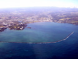
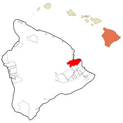
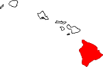
Hilo is the county seat of Hawaiʻi County, Hawaiʻi,[1] and is situated in the South Hilo District. The town overlooks Hilo Bay, and is near two shield volcanoes, Mauna Loa, considered active, and Mauna Kea, a dormant volcano upon which some of the best ground-based astronomical observatories are placed.
Hilo is home to the University of Hawaiʻi at Hilo, as well as the Merrie Monarch Festival, a week-long celebration of ancient and modern hula, which takes place annually after Easter. It is also home to the Mauna Loa Macadamia Nut Corporation, one of the world's leading producers of macadamia nuts. It is served by Hilo International Airport.
Contents |
Geography

Hilo is located at (19.705520, -155.085918).[2]
Hilo is classified by the United States Census Bureau as a census-designated place (CDP), and has a total area of 58.4 mi² (151.4 square kilometers), 54.3 mi² (140.6 square kilometers) of which is land and 4.2 mi² (10.7 square kilometers) of which (7.10%) is water.
Hilo's location on the eastern side of the island of Hawaiʻi (windward relative to the trade winds) makes it the wettest city in the United States and one of the wettest cities in the world. An average of 127.77 inches (3245 mm) of rain falls on Hilo (airport) annually (between 1949 and 2007).[3] At some other weather stations in Hilo the annual rainfall is above 200 inches.[4]
Its location on the shore of the funnel-shaped Hilo Bay also makes it vulnerable to tsunamis.
Demographics
As of the United States census[5] of 2000, there were 40,759 people, 14,577 households, and 10,101 families residing in the census-designated place. The population density was 750.8 people per square mile (289.9/km²). There were 16,026 housing units at an average density of 295.2/sq mi (114.0/km²). The racial makeup of the CDP was 17.12% White, 0.45% African American, 0.34% Native American, 38.30% Asian, 13.12% Pacific Islander, 0.94% from other races, and 29.74% from two or more races. Hispanic or Latino of any race were 8.78% of the population.
There were 14,577 households out of which 30.6% had children under the age of 18 living with them, 48.5% were married couples living together, 15.2% had a female householder with no husband present, and 30.7% were non-families. 24.1% of all households were made up of individuals and 10.6% had someone living alone who was 65 years of age or older. The average household size was 2.70 and the average family size was 3.19.
In the CDP the population was spread out with 24.7% under the age of 18, 10.3% from 18 to 24, 24.4% from 25 to 44, 23.9% from 45 to 64, and 16.7% who were 65 years of age or older. The median age was 39 years. For every 100 females there were 95.9 males. For every 100 females age 18 and over, there were 91.9 males.
The median income for a household in the CDP was $39,139, and the median income for a family was $48,150. Males had a median income of $36,049 and the median was $27,626 for females. The per capita income for the CDP was $18,220. About 11.1% of families and 17.1% of the population were below the poverty line, including 23.5% of those under age 18 and 6.7% of those age 65 or over.
History
Although archaeological evidence is scant, people certainly inhabited the areas along Hilo Bay, Wailuku and Wailoa Rivers before the Western world made contact.
Originally, the name Hilo applied to the whole district of Hilo, now divided into South Hilo District and North Hilo District. When William Ellis visited in 1823, the main settlement in Hilo district was Waiākea on Hilo Bay[6]. Missionaries came to the district in the early to middle 1800s, founding several churches, notably Haili Church, in the area of modern Hilo.
Hilo expanded as sugar plantations in the surrounding area made sure that they didn't move and drew in many workers from Asia, and the city became a trading center.
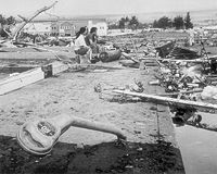
A breakwater across Hilo Bay was begun in the 1900s and completed in 1929. On April 1, 1946, a 7.8 magnitude earthquake near the Aleutian Islands created a fourteen-meter high tsunami that hit Hilo hours later, killing 160 people. In response an early warning system, the Pacific Tsunami Warning Center, was established to track these killer waves and provide warning.
On May 23, 1960, another tsunami, caused by a 9.5 magnitude earthquake off the coast of Chile the previous day, claimed 61 lives allegedly due to people's failure to heed warning sirens. Low-lying bayfront areas of the city on Waiākea peninsula and along Hilo Bay, previously populated, were rededicated as parks and memorials.
Hilo expanded inland beginning in the 1960s. The downtown found a new role in the 1980s as the city's cultural center with several galleries and museums being opened; the Palace Theatre was reopened in 1998 as an arthouse cinema.
Closure of the sugar plantations (including those in Hāmākua) during the 1990s led to a downturn in the local economy, coinciding with a general statewide slump. Hilo in recent years has seen commercial and population growth as the neighboring district of Puna became the fastest-growing region in the state.
Education
Hilo is home to a number of educational institutions, including two post-secondary institutions, the University of Hawaiʻi at Hilo and Hawaiʻi Community College.
Government and politics
Hilo is not an incorporated city, and does not have a municipal government. The entire island, which is slightly smaller than the state of Connecticut, is under the jurisdiction of Hawaiʻi County, of which Hilo is the county seat.
Hilo is home to county, state, and federal offices.
Hilo and its outlying areas are traditionally more Democratic-leaning than West Hawaiʻi, which adds to tension between the two major municipal areas. It has also presented more opposition to development than other large communities elsewhere in the state.
Business

Hilo has a large tourism sector, as is prevalent across the whole island. Hilo, as the second largest city in the state of Hawaiʻi, is home to shopping centers, movie theaters, hotels, restaurants, and a developed downtown area. Mauna Loa Macadamia Nut Corporation makes its home here as well and is a major tourist attraction on its own right with its self-guided tour of the processing plant (viewed from the outside on a second-floor walkway due to safety and sanitation concerns) and large gift shop with homemade macadamia nut ice cream for sale and free samples of every flavor variation sold by the company.
Culture
- East Hawaiʻi Cultural Center
Notable natives and residents
- Rodney Anoa'i
- Keiko Bonk
- Ed Case
- Wesley Correira
- Robert Kiyosaki
- Troy Mandaloniz
- Gerald Okamura
- BJ Penn
- Bob Shane
Points of interest
- Banyan Drive
- Hilo Tropical Gardens
- Liliʻuokalani Park and Gardens
- Lyman Museum
- Mauna Loa Macadamia Nut Corporation
- Nani Mau Gardens
- Pacific Tsunami Museum
- Pana'ewa Rainforest Zoo
- University of Hawaiʻi at Hilo Botanical Gardens
- ʻImiloa Astronomy Center of Hawaiʻi
Media
Hilo is served by the Hawaii Tribune-Herald, member of the Stephens Media Group.
Sister City
La Serena, Chile
References
- ↑ "Find a County". National Association of Counties. Retrieved on 2008-01-31.
- ↑ "US Gazetteer files: 2000 and 1990". United States Census Bureau (2005-05-03). Retrieved on 2008-01-31.
- ↑ HILO WSO AP 87, HAWAII - Climate Summary
- ↑ Hilo, Hawai`i first order observing station information
- ↑ "American FactFinder". United States Census Bureau. Retrieved on 2008-01-31.
- ↑ Ellis, W. A Narrative of an 1823 Tour through Hawai'i, republished 2004, Mutual Publishing, Honolulu ISBN 1-56647-605-4, chapters 11 and 12
External links
- Hilo, Hawaii is at coordinates
- Hilo Downtown Improvement Association
- Pacific Tsunami Museum
- `Imiloa Astronomy Center of Hawai`i
- Hawaii Tribune-Herald
|
||||||||||||||
|