Hertfordshire
| Hertfordshire | |
|---|---|
| Motto of County Council: Trust and fear not | |
 |
|
| Geography | |
| Status | Ceremonial & Non-metropolitan county |
| Origin | Historic |
| Region | East of England[1] |
| Area - Total - Admin. council |
Ranked 36th 1,643 km² (634 sq mi) Ranked 32nd |
| Admin HQ | Hertford |
| ISO 3166-2 | GB-HRT |
| ONS code | 26 |
| NUTS 3 | UKH23 |
| Demography | |
| Population - Total (2007 est.) - Density - Admin. council |
Ranked 15th 1,066,100 649/km² (1,681/sq mi) Ranked 6th |
| Ethnicity | 88.8% White British 1.7% White Irish 3.2% White Other 1.6% Indian |
| Politics | |
| Hertfordshire County Council | |
| Executive | Conservative |
| Members of Parliament | |
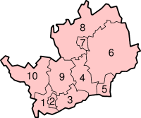
| Districts | |
|
|
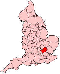
Hertfordshire (pronounced /ˈhɑrtfərdʃər/ listen, abbreviated Herts) is a ceremonial and non-metropolitan county in the East region of England. The county town is Hertford.
The county is one of the Home Counties and lies inland, bordered by Greater London, Buckinghamshire, Bedfordshire (with the borough of Luton), Cambridgeshire and Essex.
Contents |
History
Hertfordshire was originally the area assigned to a fortress constructed at Hertford under the rule of Edward the Elder in 913. The name Hertford is derived from the Anglo-Saxon heort ford, meaning deer crossing (of a watercourse). The name Hertfordshire first appears in the Anglo-Saxon Chronicle in 1011. Deer feature prominently in many county emblems.
The area has a history dating back to the Middle Stone Age. It was first farmed during the Neolithic period and permanent habitation appeared at the beginning of the Bronze Age. This was followed by tribes settling in the area during the Iron Age.
Following the Roman conquest of Britain in AD 43, Hertfordshire adapted quickly to the Roman way of life; one of the new towns, Verulamium, became the third largest town in Roman Britain. After the Romans left Britain, the Anglo-Saxons occupied the area, creating their own towns, including the county town of Hertford.
The Norman conquest in 1066 reached its climax at Berkhamsted where William the Conqueror accepted the final Saxon surrender. After the Norman conquest, Hertfordshire was used for some of the new Norman castles at Bishop's Stortford and at the royal residence of Berkhamsted.
The Domesday Book recorded the county as having nine hundreds. Tring and Danais became one, Dacorum, from (Danis Corum or Danish rule harking back to a Viking not Saxon past). The other seven were Braughing, Broadwater, Cashio, Edwinstree, Hertford, Hitchin and Odsey.
As London grew, Hertfordshire became conveniently close to the English capital; much of the area was owned by the nobility and aristocracy, this patronage helped to boost the local economy. However, the greatest boost to Hertfordshire came during the Industrial Revolution, after which the population rose dramatically. In 1903, Letchworth became the world's first garden city and Stevenage became the first town to redevelop under the New Towns Act 1946.
In 1965 under the London Government Act 1963 East Barnet Urban District and Barnet Urban District were abolished and their area was transferred to Greater London to form part of the present-day London Borough of Barnet. At the same time the Potters Bar Urban District of Middlesex was transferred to Hertfordshire.
From the 1920s until the late 1980s, the town of Borehamwood was home to one of the major British film studio complexes, including the MGM-British Studios. Many well-known films were made here including the first three Star Wars movies (IV, V, & VI). The studios generally used the name of Elstree (the adjoining village).
In early December 2005 the 2005 Hemel Hempstead fuel depot explosions occurred at the Hertfordshire Oil Storage Terminal.
In 2012, the town of Waltham Cross, within the borough of Broxbourne, will host the canoe and kayak slalom events of the 2012 Summer Olympic Games.
Following a proposal put forward by The Welwyn Garden Heritage Trust, town-planner Andrés Duany has suggested that designated "Garden Villages" could be built within Hertfordshire to relieve some of the pressure for new homes, with perhaps a third Garden City to follow.
Geography
Hertfordshire is located immediately to the north of Greater London and is part of the East of England Government Office Region.[1] Much of the county is part of the London commuter belt. To the east of Hertfordshire is Essex, to the west is Buckinghamshire and to the north are Bedfordshire and Cambridgeshire.
The highest point in the county is 803 feet (245 m) above sea level, a quarter mile (400 m) from the village of Hastoe near Tring.
As part of a 2002 marketing campaign, the plant conservation charity Plantlife chose the Pasqueflower as Hertfordshire's county flower.
Geology
The rocks of Hertfordshire belong to the great shallow syncline known as the London Basin. The beds dip in a south-easterly direction towards the syncline's lowest point roughly under the River Thames. The most important formations are the Cretaceous Chalk, exposed as the high ground in the north and west of the county, forming the Chiltern Hills and the younger Palaeocene, Reading Beds and Eocene, London Clay which occupy the remaining southern part. The eastern half of the county was covered by glaciers during the Ice Age and has a superficial layer of glacial boulder clays.
Natural resources
Despite the spread of built areas, much of the county is given over to agriculture. One product, now largely defunct, was water-cress, based in Hemel Hempstead and Berkhamsted supported by reliable, clean rivers.
Some quarrying of sand and gravel occurs in the St. Albans area. In the past, clay has supplied local brick-making and still does in Bovingdon, just south-west of Hemel Hempstead.
Fresh water is supplied to London from Ware, using the New River built by Hugh Myddleton and opened in 1613. Most of the county's own supply comes from the chalk aquifer. Local rivers, although small, supported developing industries such as paper production at Nash Mills.
Urban areas
- See also: list of places in Hertfordshire
Economy
This is a chart of trend of regional gross value added of Hertfordshire at current basic prices published (pp.240-253) by Office for National Statistics with figures in millions of British Pounds Sterling.
| Year | Regional Gross Value Added[notes 1] | Agriculture[notes 2] | Industry[notes 3] | Services[notes 4] |
|---|---|---|---|---|
| 1995 | 11,742 | 96 | 3,292 | 8,354 |
| 2000 | 18,370 | 77 | 4,138 | 14,155 |
| 2003 | 20,937 | 82 | 4,348 | 16,507 |
Hertfordshire has headquarters of many large well-known UK companies. Hemel Hempstead is home to DSG International. Tesco are based in Cheshunt. Pure Digital the DAB radio maker is based in Kings Langley. JD Wetherspoon is in Watford. Comet and Skanska are in Rickmansworth. Hatfield used to be connected with the aircraft industry, as it was where de Havilland developed the world's first commercial jet liner, the Comet. Now the site is a business park and new campus for the University of Hertfordshire. This major new employment site is home to, among others, T-Mobile, Computacenter and Ocado. A subsidiary of BAE Systems, EADS and Finmeccanica in Stevenage, MBDA, develops missiles. In the same town EADS Astrium produces satellites. The National Pharmacy Association (NPA), the trade association for all of the UK's community pharmacies, is based in St. Albans.
The loss of aircraft manufacture at Hatfield is just one of a number of industrial losses as companies capitalise on land values and move to regions where land is cheaper and recruitment is easier. Examples include Scammell, (formerly of Watford), DRG (Hemel Hempstead) and Lucas (also Hemel). In general, the land thus freed has been used for housing or service industries.
Landmarks
Below is a list of places, large and small, to visit in Hertfordshire.
- Aldenham Country Park
- Ashridge estate and house. The Neo Gothic house by James Wyatt, is a Grade 1 listed building (and is not open to the public) but the estate is National Trust land.
- Bridgewater Monument built in 1832 in memory of Francis Egerton, 3rd Duke of Bridgewater. 108 feet (33 m) tall and open to the public to ascend to the top.
- Berkhamsted Castle
- de Havilland Aircraft Heritage Centre, between London Colney and South Mimms
- Gardens of the Rose, Chiswell Green, near St Albans. Home of the Royal National Rose Society
- Hatfield
- Hatfield House – Jacobean house, gardens and park
- Mill Green Watermill in Hatfield
- Henry Moore Foundation, Much Hadham – sculpture park on the work of Henry Moore
- Knebworth House, 250 acres (1.0 km2) of country park, venue of regular rock and pop festivals.
- Magic Roundabout (Hemel Hempstead) a complex road junction.
- Royston Cave in Royston town centre
- St Albans
- Shaw's Corner, Ayot St Lawrence – home of George Bernard Shaw
- Stevenage – the first UK New Town
- Six Hills Roman barrows site
- Therfield Heath – a local nature reserve in the north of the county.
- Welwyn Viaduct to the north of Welwyn Garden City.
- Rye House Gatehouse in Hoddesdon (part of the Rye House Plot to assassinate King Charles II).
- Walter Rothschild Zoological Museum, Tring. One of the finest collections of stuffed mammals, birds, reptiles and insects in the UK.
Transport
Hertfordshire lies across routes between London and the North, the North-West and the Midlands and as a consequence it is well-served by road and rail routes and, in the past, by canals.
The county has always been traversed by some of the principal roads in England, originally the A1 (Great North Road) to Yorkshire and Scotland, A5 (Watling Street) to North Wales, A6 to North West England and the A41 (Sparrows Herne turnpike) to the Midlands and now the M1, M11, A1(M) and the M25.
Principal rail routes lie through Stevenage to Yorkshire and Scotland, and through Watford to the Midlands, Wales, the North West and Glasgow. Lesser routes serve St. Albans (and the East Midlands) and Royston (to Cambridge and Norwich). Commuter routes supplement the through routes and the London Underground extends to Watford.
Two international airports lie just outside the county Stansted and Luton. At Elstree, there is a busy airfield for light aircraft.
The Grand Union Canal passes west Hertfordshire, through Watford, Hemel Hempstead and Berkhamsted.
Education
- See also: List of schools in Hertfordshire
Hertfordshire has 26 independent schools and 73 state secondary schools. The state secondary schools are entirely comprehensive, although 7 schools in the south and southwest of the county are partially selective (see Education in Watford). All state schools have sixth forms, and there are no sixth form colleges. The tertiary colleges, each with multiple campuses, are Hertford Regional College, North Hertfordshire College, Oaklands College and West Herts College. The University of Hertfordshire is a modern university based largely in Hatfield. It has more than 23,000 students.
Notes
References
- ↑ 1.0 1.1 "The East of England". East of England Regional Assembly. Retrieved on 2007-11-14.
External links
- Hertfordshire County Council website
- Hertfordshire Constabulary website
- Population of Hertfordshire Settlements - from census 2001
- Hertfordshire, by Herbert W Tompkins, 1922, from Project Gutenberg
- GENUKI Hertfordshire Genealogy
- Hertfordshire Genealogy
|
|||||