Hattiesburg, Mississippi
| Hattiesburg, Mississippi | |
| Nickname(s): The Hub City | |
 |
|
| Coordinates: | |
| Country | United States |
|---|---|
| State | Mississippi |
| Counties | Forrest, Lamar |
| Founded | 1882 |
| Incorporated | 1884 |
| Government | |
| - Mayor | Johnny L. DuPree |
| Area | |
| - City | 49.7 sq mi (128.6 km²) |
| - Land | 49.3 sq mi (127.6 km²) |
| - Water | 0.4 sq mi (1.1 km²) |
| Elevation | 171 ft (52 m) |
| Population (United States Census) | |
| - City | 50,233 |
| - Density | 909.0/sq mi (351.0/km²) |
| - Metro | 150,000 est. |
| Time zone | CST (UTC-6) |
| - Summer (DST) | CDT (UTC-5) |
| Area code(s) | 601 |
| FIPS code | 28-31020 |
| GNIS feature ID | 0691565 |
| Website: www.hattiesburgms.com | |
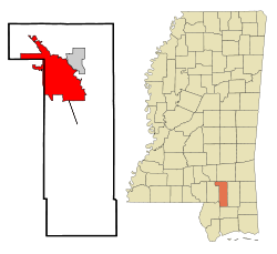
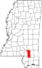
Hattiesburg, known as "The Hub City", is a city in Forrest and Lamar Counties in the U.S. state of Mississippi. It is the principal city of the Hattiesburg, Mississippi Metropolitan Statistical Area which encompasses Forrest, Lamar and Perry counties. The MSA population exceeded 150,000 as a result of a 10% increase following Hurricane Katrina in August 2005; also, Hattiesburg itself surpassed Biloxi post-Katrina to become Mississippi's third largest city. It has an incorporated suburb, Petal, and an unincorporated area, Oak Grove. It is the county seat of Forrest County,[1] but the city has grown in recent years to include a portion of eastern Lamar County. Hattiesburg is home to The University of Southern Mississippi (originally known as Mississippi Normal College) and William Carey University (formerly William Carey College). Just south of Hattiesburg is Camp Shelby, the largest National Guard training base east of the Mississippi River.
Contents |
History
Hattiesburg is positioned at the fork of the Leaf and Bouie Rivers, Hattiesburg was founded in 1882 by Captain William H. Hardy, pioneer lumberman and civil engineer. Early settlers to the area were of Scottish, Irish, and English descent who came from Georgia and the Carolinas, attracted by the vast area of virgin pine timberlands.
The city of Hattiesburg was incorporated in 1884 with a population of approximately 400. Originally called Twin Forks and later Gordonville, Hardy gave the city its final name of Hattiesburg, in honor of his wife Hattie.
Also in 1884, the railroad, known as the Southern Railway System, was built from Meridian, Mississippi through Hattiesburg to New Orleans. The completion of the Gulf and Ship Island Railroad from Gulfport, Mississippi to Jackson, Mississippi, now part of the Illinois Central System, ran through Hattiesburg and ushered in the real lumber boom in 1897. Though it was 20 years in the building, the railroad more than fulfilled its promise. It gave the state a deep water harbor, more than doubled the population of towns along its route, built the City of Gulfport and made Hattiesburg a railroad center.
Hattiesburg gained its nickname, the Hub City, in 1912 as a result of a contest in a local newspaper. This suggestion came because the city was the intersection of a number of important rail lines. Later the city also became the intersection of state highways U.S. Highway 49, U.S. Highway 98 and U.S. Highway 11, and later, Interstate 59. Hattiesburg is centrally located less than 100 miles from the state capital of Jackson as well as the Mississippi Gulf Coast, New Orleans and Mobile, Alabama.[2]
The region around Hattiesburg was also involved in the nuclear arms race of the Cold War. In the 1960s, two nuclear devices were detonated in the salt domes near Lumberton, Mississippi, about 28 miles southwest of Hattiesburg. Extensive follow-up of the area by the EPA has not revealed levels of nuclear contamination in the area that would be harmful to humans.
Throughout the 20th Century, Hattiesburg benefited from the founding of Camp Shelby (now a military mobilization center), two major hospitals, and two colleges, The University of Southern Mississippi and William Carey University. This growing metropolitan area that includes Hattiesburg, Forrest and Lamar Counties, was designated a Metropolitan Statistical Area in 1994 with a combined population of more than 100,000 residents. [3]
Despite being about 75 miles (120 km) inland, in 2005, Hattiesburg was hit very hard by Hurricane Katrina. Around 10,000 structures in the area received major damage of some type. Approximately 80 percent of the city's roads were blocked by trees and power was out in the area for up to 14 days. The storm killed 24 people in Hattiesburg and the surrounding areas. The city is strained by a large influx of temporary evacuees and new permanent residents from coastal Louisiana and Mississippi towns to the south, where damage from Katrina was catastrophic.
The City is also known for its Police Department, as it was the first, and for almost a decade the only, CALEA federally accredited law enforcement agency in the State of Mississippi. The department is serviced by its own training academy, which has traditionally been one of the most difficult basic academies in the country with over a 50% attrition rate.
The Hattiesburg Zoo has become a major attraction in the city as it continues to add attractions each year.
Civil Rights Movement in Hattiesburg
Hattiesburg and the unincorporated African American community of Palmers Crossing played a key role in the civil rights struggles of the 1960s. In 1959, black Korean War veteran Clyde Kennard applied to attend then all-white Mississippi Southern College (today University of Southern Mississippi). He was denied admission on account of his race, and when he persisted the Mississippi State Sovereignty Commission conspired to have him framed for a crime he did not commit. He was sentenced to seven years in Parchman Prison. For years, NAACP leaders Medgar Evers, Vernon Dahmer and other Forrest County civil rights activists fought to overturn this miscarriage of justice. [4]
Forrest County Registrar Theron Lynd prevented blacks from registering to vote. Thirty percent of the population was black but less than 1% of them were on the voting rolls, while white registration was close to 100%. In 1961, the U.S. Justice Department filed suit against Lynd and he became the first southern registrar to be convicted under the Civil Rights Act of 1957 for systematically violating African American voting rights.[5]
In 1962, SNCC began one of its first voter-registration projects in Hattiesburg under the auspices of COFO. In cooperation with the NAACP and local civil rights leaders they formed the Forrect County Voters League.[6] In conjunction with the 1963 elections, civil rights leaders organized a statewide "Freedom Ballot," a mock election that demonstrated both the state-wide pattern of voting rights discrimination and the strong desire of Mississippi blacks for full citizenship. Despite the serious risk of both physical and economic retaliation, almost half of Forrest County blacks participated, the highest turnout in the state.[7]
January 21, 1964, was "Freedom Day" in Hattiesburg, a major voter registration effort supported by student demonstrators and 50 northern clergymen. For the first time since Reconstruction an inter-racial protest was allowed to picket the courthouse for voting rights without being arrested. Roughly 100 African Americans attempted to register, though only a few were allowed into the courthouse and fewer still were added to the rolls.[8] Each day thereafter for many months the courthouse protest was resumed in what became known as the "Perpetual Picket."[9]
During Freedom Summer in 1964, the Hattiesburg/Palmers Crossing project was the headquarters for all civil rights activity in the 5th Congressional District and the largest and most active site in the state with more than 90 volunteers and 3,000 local participants. Hundreds of Forrest County blacks tried to register to vote at the courthouse, but most were prevented from doing so. More than 650 children and adults attended one of the seven Freedom Schools in Hattiesburg and Palmers Crossing, three freedom libraries were set up with donated books, and a community center was established. Many whites opposed civil rights efforts by blacks, and both summer volunteers and local African Americans endured arrests, beatings, firings, and evictions.[10]
Forrest County was also a center of activity for the Mississippi Freedom Democratic Party (MFDP) which sent a slate of delegates to the Democratic Convention in Atlantic City to challenge the seating of the all-white, pro-segregation delegates elected by the regular party in primaries that African Americans could not participate in. Victoria Jackson Gray of Palmers Crossing ran on the MFDP ticket against incumbent Senator John Stennis and John Cameron of Hattiesburg ran for Representative in the 5th District. With blacks still denied the vote, they knew they could not be elected, but their candidacies and campaigns advanced the struggle for voting rights.[11]
On the night of January 10, 1966, the White Knights of the Ku Klux Klan attacked the Hattiesburg home of NAACP leader Vernon Dahmer with firebombs and gunfire. Dahmer was the most prominent black leader in the county and been the primary civil rights leader for many years. Just prior to the attack, he had announced that he would help pay a $2 poll tax for black voters too poor to do so themselves. Dahmer held off the Klan with his rifle to give his wife, three young children, and elderly aunt time to escape their burning home, but he died of burns and smoke inhalation the next day. His murder sparked large protest marches in Hattiesburg. A number of Klansmen were arrested for the crime and four were eventually convicted. After four previous trials had ended in deadlocks, KKK Imperial Wizard Samuel Bowers was finally convicted in August, 1998 for ordering the assassination of Dahmer. He was sentenced to life in prison.[12][13]
Vela Uniform/Project Dribble Nuclear Tests
Vela Uniform was an element of Project Vela conducted jointly by the United States Department of Energy (DOE) and the Advanced Research Projects Agency (ARPA). Its purpose was to develop seismic methods for detecting underground nuclear testing. The Project Dribble program involved two nuclear detonations. Test SALMON occurred on October 22, 1964 and had a 5.3 kt yield; test STERLING was detonated December 3, 1966 and had a yield of 380 tons[14]. They were conducted within Tatum Salt Dome southwest of the Hattiesburg/Purvis area.
Education
Public education in Hattiesburg is served by the Hattiesburg Municipal Separate School District, servicing grades K-12.
High schools
- Hattiesburg High School (Grades 9-12)
- Sacred Heart High School (Grades Pre-K-12)
- Presbyterian Christian School (Grade Pre-K-12)
- Alpha Christian School
- The Adept School
- Oak Grove High School (Grades 9-12)
Alternative schools
- Mary Bethune Attendance Center (Grades 7-11)
Middle schools
- N. R. Burger Middle School (Grades 7 & 8)
Elementary schools
- Lillie Burney Elementary School (Grades K-6)
- Grace Christian Elementary School (Grades K-6)
- George H. Hawkins Elementary School (Grades K-6)
- Rowan Elementary School (Grades K-6)
- W.I. Thames Elementary School (Grades K-6)
- F.B. Woodley Elementary School (Grades K-6)
Colleges
Hattiesburg is home to the main campuses of two institutions of higher learning, those being the public University of Southern Mississippi and the private Baptist-supported William Carey University.
Both have campuses in other locations; USM has a campus in Long Beach, Mississippi and William Carey has campuses in Gulfport and New Orleans, Louisiana.
Private schools
- Presbyterian Christian School (Grades K-12)
- Sacred Heart Catholic School (Grades K-12)
- School of Excellence (Grades K-6)
- Lamar Christian School (Grades K-4 to 12)
- Bass Christian Elementary (Grades K-8)
- Bass Memorial Academy (Grades 9-12)
Noteworthy Facts
Birthplace of MCI/Worldcom
The idea for what became one of America's major telecommunications companies, MCI/Worldcom, was reportedly sketched out by Bernard "Bernie" Ebbers and a group of investors on a napkin during a meeting in a Hattiesburg diner. The company, incepted shortly after the breakup of AT&T, was originally known as Long Distance Discount Services (LDDS) in order to take advantage of FCC rules that subsidized new competitors.
Birthplace of Rock and Roll
Some have claimed Hattiesburg as the historic birthplace of rock and roll. This idea stems from an essay written in 1976 by respected blues scholar Robert Palmer, in the Rolling Stone Illustrated History of Rock and Roll[15]. Palmer referred to 1936 recordings made in Hattiesburg, reportedly at the train station, by Blind Roosevelt Graves, his brother Uaroy and pianist Cooney Vaughn, billed as the Mississippi Jook Band. He stated that they "...featured fully formed rock and roll guitar riffs and a stomping rock and roll beat." Palmer did not conclude from this that Hattiesburg was the birthplace of rock and roll, and indeed went on to state that "it is possible, with the help of a little hindsight, to find rock roots at almost every stratum of American folk and popular music during the mid-Thirties." The Hattiesburg recordings were very rhythmic, but are of unamplified instruments, in many respects typical of Southern rural "jook bands" of the period. They are nevertheless historically important as exemplifying one of the many elements which led to the development of rock and roll over the subsequent twenty years.
- For further information see First rock and roll record.
Hub City
Due to the location of Hattiesburg, especially in regards to the railroad industry, it's known as the "Hub City". Hattiesburg is centrally located less than 100 miles from the state capital of Jackson as well as the Mississippi Gulf Coast, New Orleans and Mobile, Alabama.
Notable Residents (Past & Present)
- Victoria Gray Adams, Educator and civil rights leader
- Wally Berg, First American mountaineer to summit Lhotse in 1990
- Jesse L. Brown, First African-American naval aviator in the United States Navy
- Shea Curry, Actress
- Vernon Dahmer, Civil rights leader killed in Hattiesburg by Klansmen in 1966
- Brett Favre, Quarterback for USM, the Green Bay Packers, and the New York Jets, 3 time NFL MVP
- Tim Floyd, Head coach of the University of Southern California men's basketball team
- Afroman, Musician (born as well as raised in Palmdale but also raised in Hattiesburg)
- Joey Gathright, MLB Outfielder
- Todd Grisham, World Wrestling Entertainment Announcer, currently the play by play announcer for the ECW Brand.
- Gary Grubbs, Hollywood and television actor
- Charlie Hayes, Former professional baseball player
- Beth Henley, Pulitzer-prize winning writer
- Eddie Hodges, Actor
- Fred Lewis, Outfielder for the San Francisco Giants
- Danny Manning, Former professional basketball player
- Walter E. Massey, Former president of Morehouse College and director of the National Science Foundation under G.H.W. Bush
- Oseola McCarty, Famous benefactor and winner of the Presidential Citizens Medal
- Matt Miller, Professional baseball player
- Jonathan Papelbon, Pitcher for the Boston Red Sox
- Van Dyke Parks, Musician
- Stephen Purdy, Broadway Musician and Vocal Teacher
- Purvis Short, Former NBA professional basketball player
- Robert L. Stewart, NASA astronaut
- James Wheaton, Actor, director and educator (lived there from infancy until age 12)
- Webb Wilder, Musician and actor
- Craig Wiseman, Songwriter
- Walter Young, professional baseball player
- Louis Lipps,Former NFL Pro-Bowl Wide Receiver and 1984 AFC Rookie of the Year, Pittsburgh Steelers
- Jimmy Buffett, Musician
- Clifton Hyde, Musician
- Walter H. Yates, Jr., Major General, U.S. Army
- Ray Guy, Former punter for the Oakland Raiders
Geography
Hattiesburg is located at (31.315974, -89.308658).[16] Most of Hattiesburg is in Forrest County. A small portion on the west side is in Lamar County. This consists of first, a narrow stretch of land lying east of I-59 and second, of an irregularly-shaped extension into West Hattiesburg. In the 2000 census, 42,475 of the city's 44,779 residents (94.9%) lived in Forrest County and 2,304 (5.1%) in Lamar County.[17]
According to the United States Census Bureau, the city has a total area of 49.7 square miles (128.6 km²), of which, 49.3 square miles (127.6 km²) of it is land and 0.4 square miles (1.1 km²) of it (0.83%) is water.
Climate
Hattiesburg has a humid subtropical climate, with short, mild winters and hot, humid summers.
| Month | Jan | Feb | Mar | Apr | May | Jun | Jul | Aug | Sep | Oct | Nov | Dec | |
|---|---|---|---|---|---|---|---|---|---|---|---|---|---|
| Average high °F (°C) | 60 (16) |
64 (18) |
71 (22) |
78 (26) |
84 (29) |
90 (32) |
92 (33) |
92 (33) |
88 (31) |
80 (27) |
70 (21) |
62 (17) |
|
| Average low °F (°C) | 36 (2) |
39 (4) |
46 (8) |
53 (12) |
61 (16) |
68 (20) |
71 (22) |
71 (22) |
66 (19) |
53 (12) |
45 (7) |
38 (3) |
|
| Precipitation inches (mm) | 7.04 (178.8) |
5.07 (128.8) |
6.31 (160.3) |
5.57 (141.5) |
5.29 (134.4) |
4.34 (110.2) |
5.64 (143.3) |
4.84 (122.9) |
4.26 (108.2) |
3.57 (90.7) |
5.29 (134.4) |
5.25 (133.4) |
|
| Source: [18] | |||||||||||||
Demographics
| Historical populations | |||
|---|---|---|---|
| Census | Pop. | %± | |
| 1890 | 1,172 |
|
|
| 1900 | 4,175 | 256.2% | |
| 1910 | 11,733 | 181% | |
| 1920 | 13,270 | 13.1% | |
| 1930 | 18,601 | 40.2% | |
| 1940 | 21,026 | 13% | |
| 1950 | 29,474 | 40.2% | |
| 1960 | 34,989 | 18.7% | |
| 1970 | 39,648 | 13.3% | |
| 1980 | 40,829 | 3% | |
| 1990 | 45,325 | 11% | |
| 2000 | 44,779 | −1.2% | |
| Est. 2007 | 50,233 | 12.2% | |
As of the census[19] of 2000, there were 44,779 people, 17,295 households, and 9,391 families residing within the city limits. This did not include on campus residents of the University of Southern Mississippi nor troops housed on or around the Camp Shelby area. Additionally, a sizable portion of the Hattiesburg metropolitan population live in unincorporated areas like Oak Grove. On any given day it is estimated that there are 150,000-165,000 people within the city limits. The population density was 909.0 people per square mile (351.0/km²). There were 19,258 housing units at an average density of 391.0/sq mi (150.9/km²). The racial makeup of the city was 49.95% White, 47.34% African American, 0.15% Native American, 1.22% Asian, 0.02% Pacific Islander, 0.52% from other races, and 0.80% from two or more races. Hispanic or Latino of any race were 1.41% of the population.
There were 17,295 households out of which 25.3% had children under the age of 18 living with them, 31.1% were married couples living together, 19.4% had a female householder with no husband present, and 45.7% were non-families. 34.4% of all households were made up of individuals and 9.3% had someone living alone who was 65 years of age or older. The average household size was 2.29 and the average family size was 3.01.
In the city the population was spread out with 21.5% under the age of 18, 24.4% from 18 to 24, 26.3% from 25 to 44, 16.0% from 45 to 64, and 11.8% who were 65 years of age or older. The median age was 27 years. For every 100 females there were 85.3 males. For every 100 females age 18 and over, there were approximately 81.3 males.
The median income for a household in the city was $24,409, and the median income for a family was $32,380. Males had a median income of $26,680 versus $19,333 for females. The per capita income for the city was $15,102. About 21.5% of families and 28.3% of the population were below the poverty line, including 36.3% of those under age 18 and 16.7% of those age 65 or over.
Media
FM Radio Stations
- WUSM-FM 88.5- (Public Radio)
- WAII 89.3- American Family Radio (Christian Contemporary)
- WJMG 92.1- G 92 (Urban Contemporary)
- WGDQ 93.1- (Urban Contemporary)
- WKZW KZ 94.3 (Hot Adult Contemporary)
- WBBN B95(Country Music)
- WXHB 96The Hub (Southern Gospel)
- WFMMSupertalk Mississippi (Talk)
- WMXI News98 (News/Sports Talk)
- WHER Eagle 99.3(Classic Country)
- WNSL SL100 (Pop music)
- WJKX 102jkx (Old School R&B)
- WUSW Real Rock 103.7 The Fox (Active rock)
- WXRR Rock104 (Classic rock)And Southern Miss Football
- WQID-LP 105.3- (hip hop,R&B,Gospel)
- WZLD Wild 106.3 (Urban)
- WKNZ 107.1- K-LOVE (Contemporary Christian)
AM Radio Stations
- WEEZ 890 (Blues)
- WHSY (News/Talk)
- WFOR 1400 (Fox Sports Radio)
- WORV 1580 (Gospel Music)
TV Stations
- WDAM Channel 7 (NBC)
- WHLT Channel 22 (CBS)
- WHPM-LP Channel 30 (Lifesat)
- W47BP Channel 47 (PBS) Mississippi Public Broadcasting
Newspapers:
- The Hattiesburg American, Hattiesburg's only daily newspaper.
- The Burger, Hattiesburg's only free press, now only online at The Burger dot org
Magazine
- South Mississippi Scene [1]
Transportation
Amtrak's Crescent train connects Hattiesburg with the cities of New York, Philadelphia, Baltimore, Washington, Charlotte, Atlanta, Birmingham and New Orleans. The Amtrak station is located at 308 Newman Street.
Hattiesburg owns and operates the city's mass transit service, H.A.R.T, Hattiesburg Area Readi Transit, or HCT, Hub City Transit. HCT offers daily routes to many major thoroughfares. The Intermodal Depot downtown services Amtrak as well as the city transit services.
The Hattiesburg-Laurel Regional Airport, located northeast of Hattiesburg, offers daily flights between Hattiesburg and Memphis, TN.
The city of Hattiesburg maintains the Hattiesburg - Bobby L. Chain Municipal Airport (HBG) in the Forrest County Industrial Park. Located four miles south of the city center, the municipal airport provides business and general aviation services for much of South Mississippi.
Hattiesburg is served by Interstate Highway 59, U.S. Highway 49, U.S. Highway 98, and U.S. Highway 11.
References
- ↑ "Find a County". National Association of Counties. Retrieved on 2008-01-31.
- ↑ Reagan L. Grimsley, Hattiesburg In Vintage Postcards, (SC: Arcadia Publishing, 2004.)
- ↑ Reagan L. Grimsley, Hattiesburg in Vintage Postcards, Arcadia Publishing, 2004.
- ↑ Clyde Kennard Framed and Jailed in MS ~ Civil Rights Movement Veterans
- ↑ United States of America vs. Theron C. Lynd - University of Southern Mississippi
- ↑ Historic Sites of the Civil Rights Movement in Hattiesburg - University of Southern Mississippi
- ↑ Freedom Ballot in MS ~ Civil Rights Movement Veterans
- ↑ Freedom Day in Hattiesburg ~ Civil Rights Movement Veterans
- ↑ Branch, Taylor (1998). Pillar of Fire. Simon & Schuster.
- ↑ Randall, Herbert (2001). Faces of Freedom Summer. University of Alabama Press.
- ↑ Carson, Clayborne (1981). In Struggle: SNCC and the Black Awakening of the 1960s. Harvard University Press.
- ↑ Davis, Townsend (1998). Weary Feet, Rested Souls. W.W. Norton.
- ↑ Biography of Sam Bowers. University of Missouri-Kansas City School of Law. Retrieved on April 24, 2008.
- ↑ "United States Nulear Tests: July 1945 through September 1992". US Department of Energy Nevada Operations Office (2000-12). Retrieved on 2008-09-11.
- ↑ Robert Palmer, "Rock Begins", Rolling Stone Illustrated History of Rock and Roll, 1976/1980, ISBN 0-330-26568-7 (UK edition)
- ↑ "US Gazetteer files: 2000 and 1990". United States Census Bureau (2005-05-03). Retrieved on 2008-01-31.
- ↑ "Subcounty population estimates: Mississippi 2000-2006" (CSV). United States Census Bureau, Population Division (2007-06-28). Retrieved on 2007-07-21.
- ↑ "Average Weather for Hattiesburg, MS - Temperature and Precipitation". The Weather Channel. Retrieved on July 11, 2008.
- ↑ "American FactFinder". United States Census Bureau. Retrieved on 2008-01-31.
External links
- City of Hattiesburg official website
- Hattiesburg Area Historical Society
- Hattiesburg Visitor Information
- Hattiesburg.com - visitor and business information
- History of Hattiesburg's Jewish community (from the Institute of Southern Jewish Life)
- Lake Terrace Convention Center - Mississippi's Premier Meeting Facility
- The University of Southern Mississippi McCain Library and Archives--Blind Roosevelt Graves and His Brother
- Hattiesburg-Bobby L. Chain Municipal Airport (HBG)
- Hattiesburg, Mississippi is at coordinates
- Hattiesburg Community Forums
|
|||||||||||||||||
|
|||||||||||||||||||||||
|