Hanover, New Hampshire
| Hanover, New Hampshire | |
 |
|
| Coordinates: | |
| Country | United States |
|---|---|
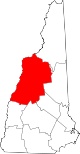
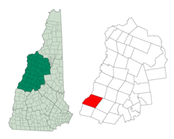
| State | New Hampshire |
| County | Grafton |
| Incorporated | 1761 |
| Government | |
| - Board of Selectmen | Brian F. Walsh, Chairman William R. Baschnagel Peter L. Christie Katherine S. Connolly |
| Area | |
| - Total | 50.2 sq mi (130.0 km²) |
| - Land | 49.1 sq mi (127.1 km²) |
| - Water | 1.1 sq mi (2.9 km²) 2.23% |
| Elevation | 528 ft (161 m) |
| Population (2000) | |
| - Total | 10,850 |
| - Density | 221.0/sq mi (85.3/km²) |
| Time zone | Eastern (UTC-5) |
| - Summer (DST) | Eastern (UTC-4) |
| ZIP code | 03755 |
| Area code(s) | 603 |
| FIPS code | 33-33860 |
| GNIS feature ID | 0873619 |
| Website: www.hanovernh.org | |
Hanover is a town along the Connecticut River in Grafton County, New Hampshire, United States. The population was 10,850 at the 2000 census. It is best known as the home of Dartmouth College. Hanover borders the towns of Lyme, Canaan, and Enfield, New Hampshire; Norwich, Vermont; and the city of Lebanon, New Hampshire. Norwich and Hanover share the first and one of the few inter-state school districts in the nation. In 2007, CNN and Money magazine rated Hanover as the second best place to live in America.[1]
The primary settlement in Hanover, where over 75% of the town's population resides, is defined as the Hanover census-designated place (CDP) and contains the areas around Dartmouth College and the intersections of New Hampshire Routes 10, 10A, and 120.
Hanover is one of the small number of towns that travellers must pass through while hiking the Appalachian Trail. The town is also the home of the US Army Corps of Engineers Cold Regions Research and Engineering Laboratory (CRREL).
Contents |
History

Hanover, New Hampshire, was chartered in 1761, and its first inhabitants arrived in 1765. At one point in its history, the southwest corner of Hanover was known as Dresden, and in the 1780s, Dresden was one of a group of neighboring New Hampshire communities that briefly defected to Vermont, when the Republic of Vermont was independent. For a time, Dresden was the capital of the Republic[2]. This status was short-lived after various political posturing.[3] As a result, Vermont rejected the communities' defections, and they were returned to New Hampshire in the US. One remnant of this era is that the name "Dresden" is still used in the Dresden School District, an interstate school district serving both Hanover and Norwich, Vermont. Hanover has been home to Dartmouth College since 1769.
Etymology
"Hannover," as it was spelled in the charter, was named either after a local parish in Connecticut or after the House of Hannover, in honor of the reigning British king, George III.[4]
While it is possible that the name "Dresden" derived from the city in Germany, it is more likely derived directly from the old Sorbian word drezg ("forest") or Drezd'ane, for an inhabitant of a forest.[5][6]
Notable inhabitants
- Al Barr, lead singer of Irish-American rock band Dropkick Murphys
- Barbara Bedford, Olympic gold medalist swimmer
- George Bissell, considered the father of the American oil industry
- Philip Booth, poet
- C. Loring Brace, anthropologist
- The Rev. Francis Brown, American Semitic scholar
- Bill Bryson, American-born British author of humorous books on travel (resident from 1995 to 2003)
- James Freeman Clarke, American preacher and author
- Charlie Clouser, music producer and former keyboardist for Nine Inch Nails
- Richard Eberhart, poet
- Thomas C. Kinkaid, Admiral of the United States Navy during World War II
- C. Everett Koop, Surgeon General from 1982-1989
- Jodi Picoult, fiction author
- Jon Spencer, blues and punk rock musician
- Armstrong Sperry, Newbery Medal-winning author, 1941-1976
- Daniel Webster, statesman
- Eleazar Wheelock, founder of Dartmouth College
- Leonard Wilcox, United States Senator from 1842-1843
Geography and climate
According to the United States Census Bureau, the town has a total area of 50.2 square miles (130 km2), of which 49.1 sq mi (127 km2) is land and 1.1 sq mi (2.8 km2) is water, comprising 2.23% of the town. The village of Hanover, or census-designated place (CDP), has a total area of 5.0 sq mi (13 km2), of which 4.6 sq mi (12 km2) is land and 0.4 sq mi (1.0 km2) is water.
The highest point in Hanover is the north peak of Moose Mountain, at 2,305 feet (703 m) above sea level. Hanover lies fully within the Connecticut River watershed.[7]
Inside the limits of Hanover are the small rural villages of Etna and Hanover Center.
The tap water of downtown Hanover is supplied by several local reservoirs. In recent years, the town has spent over $20 million to upgrade main water lines, and will undergo another $6 million project to build a new water treatment plant. Because some of the older, smaller pipes in town are still made of cast-iron, some tap water is discolored and fishy smelling, but nonetheless potable. Outside the downtown area, residents rely on private wells that are not maintained by the town.
There are a great many trails and nature preserves in Hanover, and the majority of these trails are suitable for snow shoes and cross-country skis.
| Month | Jan | Feb | Mar | Apr | May | Jun | Jul | Aug | Sep | Oct | Nov | Dec | |
|---|---|---|---|---|---|---|---|---|---|---|---|---|---|
| Average high °F (°C) | 30 (-1) | 32 (0) | 41 (5) | 53 (12) | 68 (20) | 75 (24) | 80 (27) | 77 (25) | 69 (21) | 57 (14) | 42 (6) | 32 (0) | |
| Average low °F (°C) | 8 (-13) | 10 (-12) | 21 (-6) | 32 (0) | 41 (5) | 51 (11) | 55 (13) | 53 (12) | 46 (8) | 35 (2) | 28 (-2) | 15 (-9) | |
| Average rainfall (in) | 2.6 | 2.3 | 2.6 | 2.7 | 3.2 | 3.3 | 3.6 | 3.5 | 3.2 | 3.1 | 3 | 2.7 | |
| Average rainfall (mm) | 66 | 59 | 66 | 69 | 82 | 85 | 91 | 88 | 82 | 79 | 76 | 68 | |
| Source: Weatherbase | |||||||||||||
Demographics
As of the census[8] of 2000, there were 10,850 people, 2,832 households, and 1,761 families residing in the town. The population density was 85.3 people per km² (221.0/sq mi). There were 2,989 housing units at an average density of 23.5/km² (60.9/sq mi). The racial makeup of the town was 87.98% White, 1.74% Black or African American, 0.47% Native American, 6.76% Asian, 0.06% Pacific Islander, 0.88% from other races, and 2.09% from two or more races. 2.54% of the population were Hispanic or Latino of any race.
There were 2,832 households out of which 31.1% had children under the age of 18 living with them, 55.7% were married couples living together, 4.8% had a female householder with no husband present, and 37.8% were non-families. 25.9% of all households were made up of individuals and 9.4% had someone living alone who was 65 years of age or older. The average household size was 2.47 and the average family size was 2.96.
In the town the population was spread out with 15.1% under the age of 18, 37.6% from 18 to 24, 16.6% from 25 to 44, 17.1% from 45 to 64, and 13.6% who were 65 years of age or older. The median age was 23 years. For every 100 females there were 99.1 males. For every 100 females age 18 and over, there were 96.5 males.
The median income for a household in the town was $72,470, and the median income for a family was $99,158. Males had a median income of $63,409 versus $35,771 for females. The per capita income for the town was $30,393. About 0.6% of families and 9.1% of the population were below the poverty line, including none of those under age 18 and 3.0% of those age 65 or over.
Town center
As of the census[8] of 2000, there were 8,162 people, 1,829 households, and 967 families residing in the town's central settlement, or census-designated place (CDP). The population density was 1,792.2 people per square mile (692.6/km²). There were 1,891 housing units at an average density of 415.2/sq mi (160.5/km²). The racial makeup of the CDP was 85.27% White, 2.25% Black or African American, 0.61% Native American, 8.18% Asian, 0.09% Pacific Islander, 1.13% from other races, and 2.46% from two or more races. Hispanic or Latino of any race were 3.17% of the population.
There were 1,829 households out of which 26.2% had children under the age of 18 living with them, 46.8% were married couples living together, 4.8% had a female householder with no husband present, and 47.1% were non-families. 30.9% of all households were made up of individuals and 11.3% had someone living alone who was 65 years of age or older. The average household size was 2.37 and the average family size was 2.95.
In the CDP the population was spread out with 11.1% under the age of 18, 49.0% from 18 to 24, 14.5% from 25 to 44, 12.0% from 45 to 64, and 13.5% who were 65 years of age or older. The median age was 22 years. For every 100 females there were 98.9 males. For every 100 females age 18 and over, there were 96.6 males.
The median income for a household in the CDP was $62,143, and the median income for a family was $90,548. Males had a median income of $56,667 versus $35,682 for females. The per capita income for the CDP was $26,426. About 1.0% of families and 14.7% of the population were below the poverty line, including none of those under age 18 and 4.6% of those age 65 or over.
Education
There are 3 public schools, 1 private school, 1 college, and 2 libraries in Hanover, including:
- Dartmouth College
- Hanover High School
- Frances C. Richmond Middle School
- Bernice A. Ray Elementary School
Sister cities
 Joigny, France (1993)
 Nihonmatsu, Japan (1998)
References
- ↑ http://money.cnn.com/galleries/2007/moneymag/0707/gallery.BPTL_top_100.moneymag/2.html retrieved on July 17, 2007
- ↑ Dartmouth
- ↑ The Western Rebellion
- ↑ [1] retrieved October 25, 2008
- ↑ The settlers in the riverside forest, an appellation fully compatible with that of the early inhabitants of the Hanover Plain.
- ↑ Dick Hoefnagel and Virginia L. Close. "Dresden: What Is in the Name". Retrieved on 2008-10-25.
- ↑ Foster, Debra H.; Batorfalvy, Tatianna N.; and Medalie, Laura (1995). Water Use in New Hampshire: An Activities Guide for Teachers. U.S. Department of the Interior and U.S. Geological Survey. http://nh.water.usgs.gov/Publications/nh.intro.html.
- ↑ 8.0 8.1 "American FactFinder". United States Census Bureau. Retrieved on 2008-01-31.
External links
- Town website
- New Hampshire Economic and Labor Market Information Bureau Profile
- Hanover, New Hampshire is at
|
||||||||||||||||||||