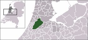
Haarlemmermeer
| Haarlemmermeer | |||
 |
|||
|
|||
 |
|||
| Coordinates: | |||
| Country | Netherlands | ||
|---|---|---|---|
| Province | North Holland | ||
| Area (2006) | |||
| - Total | 185.28 km² (71.5 sq mi) | ||
| - Land | 179.76 km² (69.4 sq mi) | ||
| - Water | 5.52 km² (2.1 sq mi) | ||
| Population (1 January, 2007) | |||
| - Total | 138,392 | ||
| - Density | 770/km² (1,994.3/sq mi) | ||
| Source: CBS, Statline. | |||
| Time zone | CET (UTC+1) | ||
| - Summer (DST) | CEST (UTC+2) | ||
| Website: www.haarlemmermeer.nl | |||
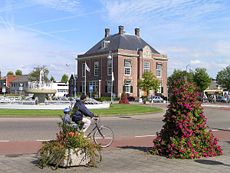
![]() Haarlemmermeer is a municipality in the Netherlands, in the province of North Holland. It is a polder, consisting of land reclaimed from water, and the name Haarlemmermeer means Haarlem's Lake, still referring to the body of water from which the region was reclaimed in the 19th century.
Haarlemmermeer is a municipality in the Netherlands, in the province of North Holland. It is a polder, consisting of land reclaimed from water, and the name Haarlemmermeer means Haarlem's Lake, still referring to the body of water from which the region was reclaimed in the 19th century.
Its main town is Hoofddorp. It is one of the largest towns (pop. 70,030) in the Netherlands whose name is not used as the name of a municipality. This town, together with the rapidly growing towns of Nieuw Vennep and Badhoevedorp, forms part of the Randstad agglomeration.
Contents |
Population centres
The municipality of Haarlemmermeer consists of the following cities, towns, villages and/or districts: Aalsmeerderbrug, Abbenes, Badhoevedorp, Beinsdorp, Boesingheliede, Buitenkaag, Burgerveen, Cruquius, De Hoek, Hoofddorp, 't Kabel, Leimuiderbrug, Lijnden, Lisserbroek, Nieuwe Meer, Nieuwebrug, Nieuw-Vennep, Oude Meer, Rijsenhout, Rozenburg, Schiphol, Schiphol-Rijk, Vijfhuizen, Weteringbrug, Zwaanshoek, Zwanenburg.
See location maps.
History
The original Haarlemmer Lake is said to have been a relic of a northern arm of the Rhine which passed through the district in Roman time, then mostly a peat bog. In 1531 the Haarlemmermeer had an area of 6,430 acres (26.0 km2), and near it were three smaller lakes: the Leidsche Meer and the Spiering Meer and the Oude Meer, with a united area of about 7,600 acres (31 km2).
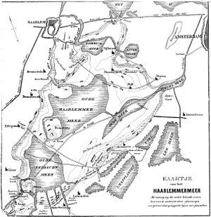
The four lakes were formed into one by successive floods. Villages disappeared in the process. One of those villages was Vennep, which the modern Nieuw Vennep was named after. By 1647 the new Haarlemmermeer had an area of about 37,000 acres (150 km2), which a century later had increased to over 42,000 acres (170 km2). In Dutch, that tendency for lakes to enlarge over time is called the waterwolf.
In 1643 Jan Adriaanszoon Leeghwater proposed to endike and drain the lake. Similar schemes, among which those of Nicolaus Samuel Cruquius in 1742 and of Baron van Lijnden van Hemmen in 1820 are worthy of special mention, were brought forward from time to time. But it was not until a furious hurricane in November 1836 drove the waters as far as the gates of Amsterdam, and another on Christmas Day sent them in the opposite direction to submerge the streets of Leiden, that the mind of the nation was seriously turned to the matter.
On August 1 1837, King William I appointed a royal commission of inquiry; the scheme proposed by the commission received the sanction of the Second Chamber in March 1839, and in the following May the work was begun.
First, a canal was dug around the lake, fittingly called Ringvaart (Ring Canal), to carry the water drainage and boat and ship traffic which had previously gone across the lake. This canal was 38 miles (61 km) long, and 8 feet (2.4 m) deep, and the dug-out earth was used to build a dike from 30 to 54 yd (30 to 50 m) wide around the lake. The area enclosed by the canal was more than 70 square miles (180 km2), and the average depth of the lake 13 feet (4.0 m). As the water had no natural drainage, it was calculated that probably 1000 million tons would have to be raised by mechanical means.

Unlike the historic practice to drain polders using windmills, steam powered pumping stations were exclusively used, a first at that time. Three steam-engines were built: the Leeghwater, the Cruquius (the largest Watt-design reciprocal stroke steam engine ever built and now a museum), and the Lijnden. Pumping began in 1848, and the lake was dry by July 1, 1852; 800 million tons were actually discharged. At the first sale of the highest lands along the banks on 16 August 1853, about 28 per acre was paid; but the average price afterwards was less. The whole area of 42,096 acres (170.36 km2) recovered from the waters brought in 9,400,000 forms, or about 780,000, exactly covering the cost of the enterprise; so that the actual cost to the nation was only the amount of the interest on the capital, or about 368,000.
The soil is of various kinds, loam, clay, sand, and peat. Most of it is fertile enough, though in the lower portions there are barren patches where the scanty vegetation is covered with an ochreous deposit. Mineral springs occur containing a very high percentage (3.245 grams per litre) of common salt; and in 1893 a company was formed for working them.
In 1854 the City of Leiden laid claim to the possession of the new territory, but the courts decided in favor of the nation. Haarlemmermeer became incorporated as a municipality in the province of North Holland by law on July 16, 1855. Its first mayor was M.S.P. Pabst. The first church was built in the same year and in 1877 there were seven. By 1860 its population was 7237, and 40 years later in 1900, it was 16,621.
Initially agriculture dominated in Haarlemmermeer. But with 99% of the land owned by a few wealthy land owners, poor harvests, and low commodity prices, life is very difficult for the farmer-renters. After 1900 it got better when commodity prices rose and most farmers owned their own land. Then also greenhouse farming developed. Seasonal labourers, attracted by good pay, boost the population by settling in the villages along the Ringvaart. Maize, seeds, cattle, butter, and cheese are the principal produce. Today large industry and office developments have become prominent, especially at Hoofddorp and Schiphol.
The roads which traverse the commune are bordered by pleasant-looking farm-houses built after the various styles of Holland, Friesland, and Brabant, reflecting the various origins of the farmers. Hoofddorp, Venneperdorp or Nieuw Vennep, Abbenes, and the vicinities of the pumping stations are the spots where the population has clustered most densely.
In 1917 a military airport was built near the old fort Schiphol. Nowadays, Schiphol Airport is the major civilian aviation hub in the Netherlands, using 15% of Haarlemmermeer's land area. In 1926 Amsterdam's municipal counsel took over the management of Schiphol. After Stockholm's airport, Schiphol was the second airport in Europe to have hardened runways, in 1937-1938. The name Schiphol means "ship hole". In the Dutch War of Independence there was a naval battle there.
Monuments and Parks


- Stelling van Amsterdam - the old defense line of Amsterdam crosses the Haarlemmermeer. Plans are being made to make this entire defense line walkable, but currently it is not possible to cross the major highway A4 that goes through it. This park is accessible at various points for recreation, including the Haarlemmermeersebos.
- Haarlemmermeersebos - The largest public park in Haarlemmermeer and site of the International garden show Floriade in 2002, the park includes a large lake for swimming in the summer and a 40 meter manmade hill called Spotter's Hill.
- Museum De Cruquius - the Cruquius museum resides in one of the steam mills used to pump the Haarlemmermeer dry and is open to the public for a demonstration of the steam engine and a model of the Netherlands waterways and polders. Because the Cruquius steam engine is the largest ever built, the museum is an Anchor Point of ERIH, The European Route of Industrial Heritage. Behind the museum is a park.
The Hydra Pier -
Transportation
Roadways
One of the busiest freeways in the Netherlands, the A4 from Amsterdam to Den Haag, crosses right through Haarlemmermeer. Other freeways are the A5, from Hoofddorp to Badhoevedorp, A9 from Alkmaar to Diemen and the A44, from Nieuw Vennep to Wassenaar.
Calatrava bridges
In the presence of HM Queen Beatrix in 2004 three bridges designed by the Spanish architect Santiago Calatrava were opened. The bridges span the main canal of the Haarlemmermeer and are named after three string instruments; Harp, Cittern, and Lute. Unfortunately, in 2006 two of those bridges' structures already displayed clear signs of corrosion.
Air transport
Schiphol Airport, the principal international airport of the Netherlands is also situated in Haarlemmermeer. Its destinations are world-wide.
Railway
Nederlandse Spoorwegen, the Dutch national railway company, serves the municipality with three stations: Hoofddorp, Nieuw-Vennep, and Schiphol.
Railway Leiden Centraal to Schiphol (part of line 10), with stations (municipalities in bold) and official station abbreviations:
|
Water transport
The Ringvaart is an important waterway for commercial and recreational boats alike. A portion of it forms part of the sailroute from Hollands Diep to the IJsselmeer, passable for ships with masts over 6 meters tall. There is also a connection to the Kaag Lake system (Kagerplassen), which extends to Leiden and beyond.
There are several canals within Haarlemmermeer itself, the main ones are Hoofdvaart (Main Canal) and Kruisvaart (Cross Canal). But these had initially no connection to the outside waterways, meaning that goods had to be reloaded at the ring dike. In 1895 a double canal lock was built at Aalsmeer, boosting the economy. In the 1950s this lock was closed and the canals are once again no longer used for shipping.
Local government
The municipal council of Haarlemmermeer consists of 39 seats, which are divided as follows:
- Leefbaar Haarlemmermeer (HAP) - 4 seats
- VVD - 10 seats
- CDA - 7 seats
- GroenLinks - 4 seats
- PvdA - 8 seats
- ChristenUnie/SGP - 2 seats
- D66 - 1 seat
- SP - 3 seats
Sister cities
The following cities have a sister city relationship with the Haarlemmermeer municipality:
 Cebu City (Philippines)
 Hódmezővásárhely (Hungary)
References
- This article incorporates text from the Encyclopædia Britannica Eleventh Edition, a publication now in the public domain. See: Haarlem lake
- Statistics are taken from the SDU Staatscourant
- http://web.haarlemmermeer.nl/issverkiezingen/exp_html/index.html
External links
|
|||||||||||

|
|||||||||||