Guimaras
| Province of Guimaras | |
Provincial seal of Guimaras |
|
 Map of the Philippines with Guimaras highlighted |
|
| Region | Western Visayas (Region VI) |
| Capital | Jordan |
| Divisions | |
| - Highly urbanized cities | 0 |
| - Component cities | 0 |
| - Municipalities | 5 |
| - Barangays | 98 |
| - Congressional districts | 1 |
| Population | 7th smallest |
| - Total (2007) | 141,450 |
| - Density | 234 /km² (606 /sq mi) (33rd highest) |
| Area | 5th smallest |
| - Total | 604.7 km2 (233 sq mi) |
| Founded | May 22, 1992 |
| Spoken languages | Hiligaynon |
| Governor | Felipe Hilan A. Nava |
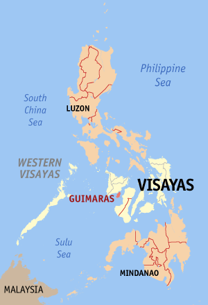
Guimaras is an island province of the Philippines located in the Western Visayas region. Among the smallest provinces, its capital is Jordan. The island is located in the Panay Gulf, between the islands of Panay and Negros. To the northwest is the province of Iloilo and to the southeast is Negros Occidental.
The province is located on the islands of Guimaras and Inampulugan.
Guimaras was a sub-province of Iloilo until it was made an independent province on May 22, 1992.
Contents |
People and culture
The people of Guimaras are considered as Guimarasnon and their languages are Hiligaynon and Kinaray-a as it was once a sub-province of Iloilo. Hiligaynon is the major language spoken although the people can understand and speak Tagalog and English.
Many foreigners are known to own big lands, ships and major businesses. Many Indians are known to have the biggest lands in Guimaras.
Economy
The province is basically agricultural with palay, coconut, mango, vegetables, livestock, poultry and fishing as major products. Its major industries are tourism, fruit processing, coconut processing, fish farming, handicrafts making, mining, quarrying and lime production.
Guimaras is well-known for its agricultural crops, particularly mangoes, where some 50,000 of these trees are planted. The Guimaras Island is famous for producing the sweetest mangoes in the world. Guimaras mangos are reportedly served at the White House and Buckingham Palace . Guimaras' largest event of the year is The Manggahan Festival (the Mango Festival). The variety of mangoes produced are also best for making dried mangoes, jam and other delicacies.
Government
House of Representatives: JC Rahman Nava
Governor: Felipe Hilan Nava
Vice Governor: Aurelio Tionado
Geography
Political
Guimaras is subdivided into 5 municipalities.
Municipalities
- Buenavista
- Jordan
- Nueva Valencia
- San Lorenzo
- Sibunag
Physical
Located southwest of Panay, Guimaras is separated physically from Iloilo by a narrow channel, which takes about fifteen minutes to cross by pumpboat from the Ortiz landing on Iloilo to Jordan. There are two other ways to get there, the Parola wharf in Iloilo to the municipality of Buenavista. The Parola wharf is used exclusively whenever the water is rough. There also is a roll on roll off (RORO) ferry that travels around five times a day and is used by the Iloilo bicycle clubs on Sunday to travel to Guimaras. Geologists opine that the island formed one landmass with Panay in the past. Guimaras was formerly known as Himal-us
Guimaras is also famous for its beaches. Clear blue waters, white sand and marine life rivals that of Boracay.Commonly visited ones are at Roca Encantada, ALubihod and Puerto del Mar.
History
Gonzalo Ronquillo de Peñalosa, a Spanish governor-general, established the Spanish settlement in Guimaras for the purpose of the Christianization of the natives of the island. He and his subordinates organized the pueblicitos or villages of Nayup, with San Pedro Apostol as the patron saint, and Igang, with Sta. Ana as the patroness.
Evangelization of Guimaras occurred around the same time the friars were making inroads in Panay. The Augustinians established the visitas of Nayup and Igang dependent on Oton, Iloilo. Gov. Gen. Dasmariñas 20 June 1551 report to the king noted that the friars of Oton made regular visits to the island.
In 1742, the island fell under the jurisdiction of Dumangas - now known as Iloilo, until 1751 when the Augustinian Order was replaced by the Jesuits, after which the Dominican order took over Guimaras. The Jesuits, who had established a school in Iloilo and had missions in Molo and Arevalo, charge of the island. By 1755, it was organized into a regular parish. When the population increased considerably, the island was given its municipal status with a seat of government at Tilad (now known as Buenavista). In 1908, during the American period, the Guimarasnons were given the opportunity to elect their municipal president.
Douglas MacArthur, a fresh graduate from West Point as a Second Lieutenant at the age of 23, came to Iloilo as the head of the company of U.S. Army Corps of Engineers. They constructed roads and the Sto. Rosario Wharf, presently named MacArthur's Wharf, which are still in use today.
In 1942, the Japanese Imperial forces landed in Guimaras Island.
In 1945, the defenders of the United States & the Philippine Commonwealth forces landed in Guimaras Island by the attacked form the Japanese Imperial forces defeated beginning to the liberation in the Battle of Guimaras.
Guimaras first gained its status as a sub-province of Iloilo by virtue of R.A. 4667, which was enacted by Congress on 18 June 1966. It was proclaimed as a regular and full-fledged province on 22 May 1992 after a plebiscite was conducted to ratify the approval of its conversion pursuant to Section 462 of R.A. 7160.
Shortly after Guimaras acquired its provincial status, President Fidel V. Ramos appointed Emily Relucio-Lopez as its first Governor.
The province of Guimaras was originally composed up of 3 municipalities. In 1995, by virtue of Republic Act No. 7896 and Republic Act No. 7897, the municipalities of Sibunag and San Lorenzo were created in the province of Guimaras. The two new municipalities officially acquired their municipal status after the May 8, 1995 plebiscite held simultaneously with the local election.
Mayor Ernesto L. Gedalanga was the first appointed mayor of Sibunag and Mayor Arsenio Zambarrano was also appointed mayor of San Lorenzo. The temporary seat of government of the Municipality of Sibunag is at Brgy. Sabang while the temporary seat of Government of the Municipality of San Lorenzo is at Brgy. Cabano.
The island province however encountered an ecological disaster on Aug. 2006, after M/V Solar I, chartered by Petron, the Philippines’ largest oil refiner, carrying 2.4 million litres of oil sank near the coast, contaminating 24 sq. km.[1] Cleanup is estimated to take at least a full year. The Philippine Coast Guard is calling this the worst oil spill in the country’s history. According to officials, 1,000 hectares of mangrove forests have been affected, including parts of the Taclong Island Sanctuary, a feeding and breeding ground for fish and other species.
External links
- Provincial Government of Guimaras
- Stay in Guimaras!
- Explore Guimaras!
- Guimaras Photo Gallery
- WWF News Bulletin on the Disaster
- Save Guimaras.com (Guimaras Oil Spill)
- Ligtas Guimaras (Guimaras Oil Spill)
- Oil Spill near Guimaras Island at NASA Earth Observatory
- The hidden jewel that is Guimaras
- Guimaras grabs tourism alternative
- Captivating Capiz - Guimaras Mango
- Capiz - Guimaras Mango
|
|||||