German East Africa
|
|||||||||||||||||||||||||||||||||||||||||||||||||||||||||||

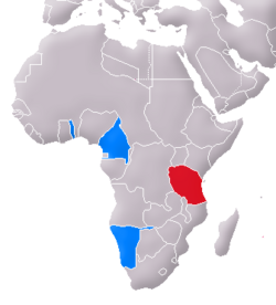
German East Africa (German: Deutsch-Ostafrika) was a German colony in East Africa, including what is now Burundi, Rwanda and Tanganyika (the mainland part of present Tanzania). It measured 994,996 km² (384,170 square miles) in size or nearly three times the size of re-united Germany today. It came into existence during the 1880s and ended during World War I, when the area was taken over by the British and Belgians, and later as League of Nations mandate territories.
Contents |
Foundation
The colony's story begins with Carl Peters, an adventurer who founded the "Society for German Colonization" and had signed some treaties with native chiefs of the mainland across from Zanzibar. On 3 March 1885, the German government announced that it had granted an imperial charter (secretly, on February 17) to Peters' company, and intended to establish a protectorate in East Africa. Peters then recruited a variety of specialists who fanned out across the country, south to the Rufiji River and north to Witu, near Lamu on the coast.


When the Sultan of Zanzibar protested (as he considered himself the ruler of the mainland), Bismarck sent five warships (including Stosch, Gneisenau and Prinz Adalbert), which arrived August 7 and trained their guns on the Sultan's palace. The net result was that the British and Germans agreed to divide the mainland into spheres of influence, and without British support the Sultan had to go along.
The Germans quickly established their rule over Bagamoyo, Dar es Salaam and Kilwa. The Abushiri Revolt started in 1888 and was put down (with British help) in the following year. In 1890, London and Berlin concluded the Heligoland-Zanzibar Treaty, a deal that gave Heligoland to Germany, and defined the limits of German East Africa (the exact borders remained ill-defined until 1910).
Between 1891 and 1894, the Hehe — led by Chief Mkwawa — resisted German expansion, but were eventually defeated because other tribes were in favour of the newcomers. After a period of guerrilla warfare, Mkwawa himself was cornered and committed suicide in 1898.
The Maji Maji Rebellion occurred in 1905, and was put down by the governor, Count Gustav Adolf von Götzen. But scandal soon followed, with stories of corruption and brutality, and in 1907 Chancellor Bülow appointed Bernhard Dernburg to reform the colonial administration, which became a model of colonial efficiency and commanded extraordinary loyalty among the natives during the First World War.
German colonial administrators relied heavily on native chiefs to keep order and collect taxes. Other than local police, garrisons of Schutztruppe soldiers at Dar es Salaam, Moshi, Iringa and Mahenge consisted on 1 January 1914 of 110 German officers (including 42 medical officers), 126 non-commissioned officers and 2,472 local soldiers (Askaris[1]).[2]
Economic development
Commerce and growth started in earnest under German direction. Early on it was realized that economic development would depend on reliable transportation. Over 100,000 acres(40,000 hectares) were under sisal cultivation - the biggest cash crop. Two million coffee trees were planted and rubber trees grew on 200,000 acres (80,000 hectares ), along with large cotton plantations. To bring these agricultural products to market, beginning in 1888, the Usambara Railroad, or Northern Railway, was built from Tanga to Moshi. The longest line, the Central Railroad covered 775 miles (1,250 kilometers) from Dar es Salaam to Morogoro, Tabora and Kigoma. The final link to the eastern shore of Lake Tanganyika had been completed in July 1914 and was cause for a huge and festive celebration in the capital with an agricultural fair and trade exhibition. Harbor facilities were built or improved with electrical cranes, with rail access and warehouses. Wharves were remodeled at Tanga, Bagamoyo and Lindi. In 1912 Dar es Salaam and Tanga received 356 freighters and passenger steamers and over 1,000 coastal ships and local trading vessels.[3] By 1914 Dar es Salaam and the surrounding province had a population of 166,000, among them 1,050 Europeans, 1,000 of them Germans. In all of the east African protectorate were 3,579 Germans.[4] In its own right, Dar es Salaam became the showcase city of all of tropical Africa.[5]
Despite all these efforts, German East Africa never achieved a profit for the German Empire and needed to be subsidized by the Berlin treasury.
Education
Unlike the Belgian, British, French and Portuguese colonial masters in central Africa, Germany developed an educational program for its Africans that involved elementary, secondary and vocational schools. “Instructor qualifications, curricula, textbooks, teaching materials, all met standards unmatched anywhere in tropical Africa.”[6] In 1924, ten years after the beginning of the First World War and six years into British rule, the visiting American Phelps-Stokes Commission reported: “In regards to schools, the Germans have accomplished marvels. Some time must elapse before education attains the standard it had reached under the Germans.”[7]
First World War
The story of German East Africa in the First World War is essentially the history of the colony's military commander, General Paul Emil von Lettow-Vorbeck. A vibrant and young officer, he spent the war harrying the forces of the British Empire, tying down with his band of 3,000 Europeans & 11,000 native Askaris and porters, a British/Imperial army 300,000 strong, which was at times commanded by the former Second Boer War commander Jan Smuts. One of his greatest victories was at the Battle of Tanga (3–5 November, 1914), where von Lettow-Vorbeck beat a British force more than eight times the size of his own.

Lettow-Vorbeck's masterful mix of guerrilla warfare and daring raids ended up costing the British war effort massive resources and upwards of 60,000 casualties. Nonetheless, weight of numbers, especially after forces coming from Belgian Congo had attacked from the West, and dwindling supplies, forced Lettow-Vorbeck into a grudging withdrawal. Ultimately, Lettow-Vorbeck fought his tiny force out of German East Africa and into Mozambique, then into Northern Rhodesia where he agreed a ceasefire three days after the end of the war, on receiving news of the armistice between the warring nations (see Von Lettow-Vorbeck Memorial for details.)
Heralded after the war as one of their heroes, the Germans celebrated Lettow-Vorbeck's Schutztruppe as the only colonial German force in the First World War not to have been defeated in open combat - although they often retreated when outnumbered. The Askari colonial troops that had fought in the East African campaign were later given pension payments by the Weimar Republic and the Federal Republic of Germany (West Germany).
The German light cruiser SMS Königsberg also fought off the coast of East Africa. She was eventually scuttled in the Rufiji delta in July 1915 after running out of fuel (coal); the crew, along with the ships guns which were stripped out and mounted on trunions, then joined the land forces adding considerably to its effectiveness.
The Treaty of Versailles broke up the colony, giving the western area to Belgium as Ruanda-Urundi, the small Kionga Triangle south of the Rovuma River to Portugal to become part of Mozambique, and the remainder to Britain, which named it Tanganyika.
Postage stamps
Main article Postage stamps and postal history of German East Africa
List of Governors, 1885-1918
- 1885-1889 Carl Peters (German East Africa Company)
- 1889-1891 Hermann von Wissmann
- 1891-1893 Julius von Soden
- 1893-1895 Friedrich von Schele
- 1895-1896 Hermann von Wissmann
- 1896-1901 Eduard von Liebert
- 1901-1906 Gustav Adolf von Götzen
- 1906-1912 Albrecht von Rechenberg
- 1912-1918 Heinrich Albert Schnee
German place-names
- Bismarckburg (Kasanga)
- Kaiser-Wilhelm-Spitze (Kilimanjaro)
- Weidmannsheil (Tabora)
See also
- List of former German colonies
- German East Africa Company
- Germans of Namibia
Footnotes
- ↑ originally an Arabic word for 'soldier' adopted from Osmanli, i.e. Ottoman Turkish, then applied to indigenous African troops in European colonies
- ↑ Haupt, Deutschlands Schutzgebiete in Übersee 1884-1918, p. 32
- ↑ Haupt, p. 30
- ↑ Haupt, p. 155
- ↑ Miller, Battle for the Bundu, p. 22
- ↑ Miller, p. 21
- ↑ Miller, p. 21
References and external links
- The coins and bank notes of German East Africa
- Schnee, Dr. Heinrich (Deputy Governor of German Samoa and last Governor of German East Africa), German Colonization, Past and Future - The Truth about the German Colonies, George Allen & Unwin, London, 1926.
- Bullock, A.L.C., Germany's Colonial Demands, Oxford University Press, 1939.
- Wikified article on German East Africa based on the 1911 edition of Encyclopedia Britannica
- East, John William. "The German Administration in East Africa: A Select Annotated Bibliography of the German Colonial Administration in Tanganyika, Rwanda and Burundi from 1884 to 1918." [London? 1989] 294 leaves. 1 reel of microfilm (negative.) Thesis submitted for the fellowship of the Library Association, London, November 1987."
- Farwell, Byron. The Great War in Africa, 1914–1918. New York: W. W. Norton & Company. 1989. ISBN 0393305643
- Miller, Charles. Battle for the Bundu, The First World War in East Africa. New York: MacMillan Publishing Co., Inc. 1974. ISBN 0025849301
- Haupt, Werner. Deutschlands Schutzgebiete in Übersee 1884-1918 (Germany’s Overseas Protectorates 1884-1918). Friedberg: Podzun-Pallas Verlag. 1984. ISBN 3790902047
- Hahn, Sievers. Afrika. 2nd Edition. Leipzig: Bibliographisches Institut. 1903.
- The New Student's Reference Work/German East Africa
|
||||||||||||||||||||||