Gera
| Gera | |
 |
|
| Coat of arms | Location |
 |
 |
| Administration | |
| Country | Germany |
|---|---|
| State | Thuringia |
| District | Urban district |
| Mayor | Norbert Vornehm (SPD) |
| Basic statistics | |
| Area | 151.93 km² (58.7 sq mi) |
| Elevation | 205 m (673 ft) |
| Population | 102,486 (30/12/2006)[1] |
| - Density | 675 /km² (1,747 /sq mi) |
| Founded | 995 |
| Other information | |
| Time zone | CET/CEST (UTC+1/+2) |
| Licence plate | G |
| Postal codes | 07457-07557 |
| Area codes | 0365, 0336695 |
| Website | www.gera.de |
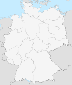
| Location of Gera within Germany | |
 |
|
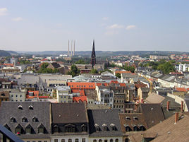
Gera is the third largest city in the German state of Thuringia after Erfurt, the Thuringian capital, and Jena. It is situated in east Thuringia on the river "White Elster" (literally the "White Magpie"), approximately 60 kilometres to the south of the city of Leipzig and 80 kilometers to the east of Erfurt. In 2006 Gera had a population of approximately 102,000.
Contents |
History
The name Gera was first mentioned in 995. From 1848 to 1918 Gera was the capital of the Reuss Junior Line principality. In 1920 the city became part of Thuringia (German: Thüringen). Large portions of the city were destroyed by aerial bombing in 1945. Until German reunification in 1990 the city belonged to the German Democratic Republic (East Germany).
Main sights
Sights in Gera include:
- Town Hall (1576, Renaissance)
- Market Square with Simson-fountain
- Castle Osterstein (largely destroyed 1945)
- City Pharmacy
- Theater (1902)
- Villa Schulenburg, designed by Henry van de Velde
- St. Johannis church (Neo-Gothic)
- St. Salvator church (Baroque with Art Nouveau interior decoration)
- St. Marien church (Late Gothic)
- St. Trinitatis church (Late Gothic)
- Old beer cellars called "Geraer Höhler"
- Zoo Gera (since 1973)
Museums in Gera include:
- City Museum
- Otto Dix House
- Art Galley "Orangerie"
- Museum of Natural History ("Schreiber House", oldest building in the city)
- Museum for Applied Arts ("Ferber House")
In 2007 Gera, together with Ronneburg, is venue of the Bundesgartenschau (the federal horticultural show).
Transportation
In the eastern part of Gera lies the airfield Gera-Leumnitz. The nearest airport is Leipzig-Altenburg (approx. 40 km). The Leipzig-Halle airport, with its with many international destinations, is about 90 km north of Gera.
Twin towns
 Nuremberg, Germany
 Saint-Denis, France
 Sliven, Bulgaria
 Plzeň, Czech Republic
 Kuopio Finland
 Timişoara, Romania
 Arnhem, Netherlands
 Rostov-on-Don, Russia
 Fort Wayne, United States
 Skierniewice, Poland
- Pskov, Russia
 Goražde, Bosnia
Notable natives
- Johann Heinrich Gottfried Koch, (1705-1775)
- Heinrich Gustav Beck, (1857-1933), Ministerpräsident of Saxony 1914-1918
- Otto Dix (1891-1969), artist
- Rudolf Paul, (1893-1978), President of Thuringia 1945-1947
- Karl Weschke, (1925-2005), painter
- Georg Buschner, (born 1925), head coach East Germany national football team
- Helga Königsdorf, (born 1938), mathematician and author
- Marlies Göhr, (born 1958), athlete
- Olaf Ludwig, (born 1960), racing cyclist
- Wolfgang Tiefensee, (born 1955), politician
- Heike Drechsler, (born 1964), Olympic gold medalist long jumper
- Jens Heppner, (born 1964), racing cyclist
References
- ↑ Thüringer Landesamt für Statistik. "Population of Thuringia by district". Retrieved on 2007-08-10.
External links
|
||||||||