Geography of Saskatchewan
| Geography of Saskatchewan | |
|---|---|
 |
|
| Continent | America |
| Region | North America Western Canada |
| Coordinates | -- |
| Area | 651,900 km² (251,700 sq mi) 90.8% land 9.2 % water |
| Borders | Total land borders: U.S. states North Dakota; Canadian provinces Alberta, Manitoba and Northwest Territories |
| Highest point | Cypress Hills 1,468 metres (4,816 ft) |
| Lowest point | Lake Athabasca shoreline |
| Longest river | Saskatchewan River |
| Largest lake | Lake Athabasca 7935 km² |
The geography of Saskatchewan (suskăch'uwun, –wän", săs"–), province (2001 pop. 978,933), 251,700 sq mi (651,900 km²), describes the land formations and physical features of this prairie province in western Canada. The various geographical branches provide an analysis of natural and human area studies. The changes of either the natural or human in an area will force an adaptation of evolution in relation to the various ecozones and terrain features. The physical land area is described by political boundaries which have changed through history. Cultural and technological changes have affected the adaptation of the human lifestyle with the regional environmental area throughout the history of Saskatchewan.
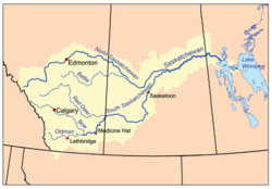
The name "Saskatchewan" is derived from the Cree word "kisiskaciwan" that means "swift flowing water" referring to the South Saskatchewan river which served as a major waterway in the eighteenth century by European explorers and fur traders. As a plains region, with the Central Lowlands to the south and wooded country in the north, it supports rich and varied wildlife, or zoogeography. The northern third is part of the Canadian Shield whereas the southwestern triangle is part of the Great Plains. Its principal rivers are the North and South Saskatchewan, the Churchill River, and the Qu'Appelle River.[1] Moreover, between the Saskatchewan and Churchill rivers, locates a mixed forest belt that produces much timber.[1] A sector of which is preserved as Prince Albert National Park.[1] Saskatchewan's economy can be described as oil, gas, potash production, grains,coal, and livestock.[1] Saskatchewan is surrounded, to the north in 1905 by the Provisional District of Mackenzie[2] which later became the Northwest Territories, to the east by Manitoba, to the south by the United States' Montana, and to the west by Alberta.[1]
The Cree Indians inhabited the plains and parkland region about five thousand years ago, living a first nation’s tribal lifestyle where the men followed the movement of bison livestock — a form of transhumance — and the women and children remained at home engaged in hunting and gathering activities. The Dene or caribou hunter resided in the northern Canadian Shield area.[1] The Hudson's Bay Company controlled the area named Rupert's Land beginning in 1670. The French established settlements in the region c. 1750, though the Hudson’s Bay Company made the first permanent settlement in 1774. The Hudson’s Bay Co. ceded Rupert’s land in 1869, and by 1870, the North West became a member of the Dominion of Canada as a part of the Northwest Territories. From 1882 into the early 1900s, the extension of the railroad brought in large numbers of European settlers, as well during this period the bison virtually became extinct. The province was established in 1905.[1][3] The biogeography of Saskatchewan's ecozones saw the development of agriculture science as plant cultivation combined with pastoralism or ranching settlements sprang up. Technological advancements resulted in the departure from subsistence techniques towards industrial agriculture and cash crops. As labour from the rural agricultural sector was not as intensive because of mechanization, other urban sectors have been developed such as business and market economic geographies as well as mineral economic geographies.[4] Regina stands as its second largest city and capital.
Contents |
Historical geography
Original peoples of the Saskatchewan consist of three linguistics groups: the Athabascan, Algonquian, and Siouan. Henry Kelsey of the Hudson's Bay Company is considered the first European person to see this area.[1] the earliest trading posts were made by the French; however, the first permanent settlement was established at Cumberland House in 1774 by the HBC. In addition, several more ports were set up by British fur traders among the area's waterways.[1] Settlement was favoured in the forested area of the Canadian Shield, and hunting/ trapping was the main economy.
In 1870, the Hudson Bay's Company (HBC) had combined with the North West Company in 1821, and then ceded its rights from the Canadian government. The region became a part of the Northwest Territories. The majority of the Canadians of the indigenous descent in the Northwest Territories sold their lands to the government in the 1870s and was settled on reservations.[1] Additional native peoples and Métis (people of mixed French and indigenous Canadian ancestry), led by Louis Riel rebelled between 1884 and 1885 and were suppressed.[1]
The arrival of settlements and the rail lines also brought agricultural economies and development in the Central Lowlands Area. The Great Plains or Palliser Triangle area to the south was mainly used for ranching economies. In the beginning of the 20th century, Saskatchewan farmers created cooperative organizations to maintain grain marketization. During the drought and depression of the 1930s, the population decreased as immigration nearly ended and numerous families left. During World War II, conservation programs and the increased demand for grain survived the economy.[1]
Climate

Saskatchewan climate can be described as temperate in the south and with cold winters in the north. The greatest rainfall occurs between April and June.[5] Summers are hot and humid, dry with tedious hours of sunshine. plough winds, cyclones, Supercell hail or high precipitation rain storms and tornadoes are eventful summer occurrences. Midale has the hottest recorded temperature in Canada registering at 45 °C (113 °F) on July 5, 1937. Winter temperatures are frequently cold and snowy until late March, but sunny.[5] Light to medium weights clothing during warmer months.[5] Heavyweights are worn for the winter.[5] Waterproof apparel is common throughout the year.[5]
Annual precipitations ranges are of 320 to 450 mm in the southern portion (below about 54 degrees North) where the majority of the population live.[6] The northern forest area is wetter in precipitation.[6] In the far north there is few frost-free days and the subsoils remain frozen all around the year.[6]
| Location | Annual precipitation (mm) |
Frost-free period (days) |
Days above 5 °C |
|---|---|---|---|
| Saskatoon | 347 | 118 | 1601 |
| Regina | 364 | 113 | 1661 |
| North Battleford | 368 | 122 | 1548 |
| Prince Albert | 406 | 95 | 1416 |
| Estevan | 418 | 128 | 1783 |
| Kindersley | 324 | 116 | 1592 |
| Moose Jaw | 357 | 122 | 1773 |
| Swift Current | 367 | 120 | 1583 |
| Yorkton | 436 | 112 | 1530[6] |
Urban areas
Saskatchewan's capital is Regina. Its most populous city is Saskatoon. Other major cities include Estevan, Flin Flon (part), Humboldt, Lloydminster (part), Melfort, Melville, Moose Jaw, North Battleford, Prince Albert, Swift Current, Weyburn, and Yorkton
|
|
Vegetation
- See also: Prairie
- See also: Canadian Prairies
- See also: Canada's landforms#The Canadian Shield
- See also: Canada's landforms#The Interior Plains
- See also: Canadian Shield
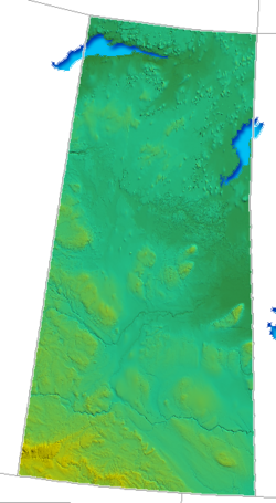
Saskatchewan has three major landforms, the Canadian Shield area north of the tree line, and grassland prairie plains or Central Lowlands that are treeless south of the tree line. The northern section is covered in lakes and trees. The Great Plains are shown in yellow on the geography of Saskatchewan image at the top of this page and the Saskatchewan portion has been known as the Palliser's Triangle.
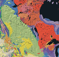
Red area Canadian Shield
Green area Central Lowlands
Southwest corner Great Plains
| Physiographic Region | Bedrock Geology | Dominant soils | Natural Vegetation |
|---|---|---|---|
| Canadian Shield | |||
| Rock knob complex | Igneous rocks and Precambrian Missi Series | Lodzolic forest soils | Lichen woodland black spruce pine |
| Athabasca Plains | Precambrian Athabasca Formation | Rough rock land; bedrock exposures | pine |
| Central Lowlands | |||
| Manitoba Lowlands | Cretaceous formations | Chernozemic soils | Aspen fescue spear/wheat grass |
| Saskatchewan Plains | Cretaceous formations | Chernozemic soils | Aspen fescue spear/wheat grass |
| Great Plains | |||
| Alberta Plateau | Tertiary formations | Regozolic and solonetzic soil mixtures | spear grass / blue grama |
Water
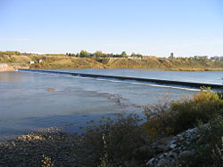
There are four main rivers which drain into the Hudson Bay watershed North and South Saskatchewan, the Churchill River, and the Qu'Appelle River.[1] There are thousands of lakes across Saskatchewan, the main region being north of the tree line in the Canadian Shield.[10]


- see also List of Saskatchewan rivers
- see also Lakes of Saskatchewan
- see also Lakes of Saskatchewan
The total area of freshwater is 59,366 km². [11]
| River | Drainage area (km²) | Length (km) |
|---|---|---|
| North Saskatchewan | 12,800 | 1,287 |
| South Saskatchewan (to head of Bow) | 1144,300 | 1,392 |
| Churchill (to head of Churchill Lake) | 281,300 | 1,609 |
| Beaver (to outlet of Beaver Lake) | 4,700 | 336 |
Source Statistics Canada
| Lake | Area (km²) | Altitude (m) | Depth (m) | Volume (km³) |
|---|---|---|---|---|
| Lake Athabasca | 7,935 | 213 | ||
| Reindeer Lake | 6,650 | 337 | ||
| Wollaston Lake | 2,681 | 398 | ||
| Cree Lake | 1,434 | 487 | ||
| Lac La Rouge | 1,413 | 364 | ||
| Peter Pond Lake | 1,434 | 421 | ||
| Doré Lake | 640 | 459 | ||
| Cold Lake |
Sources Statistics Canada, WLD, anglersatlas.com
| Lake | Additional Information |
|---|---|
| Last Mountain Lake | 156 km² (37,000 acres) of wetland and upland habitats maximum depth 30.8 m. National Wildlife Area [12] |
| Qu'Appelle Lakes | Calling Lakes / Katepwa Point Provincial Park[13] |
| Kenosee Lake | Moose Mountain Provincial Park[14] |
| Fishing Lake | Fishing Lake Regional Park[15] |
| Jackfish Lake | Meota Regional park[16] |
| Macklin Lake | Macklin Lake Regional Park[17] |
| Madge Lake | Mountain Duck Mountain Provincial Park [18] |
| Saltcoats Lake | Saltcoats Regional Park[19] [20] |
| Manitou Lake | Manitou Lake (A Division of Suffern Lake) Regional Park [21] |
| Big Quill Lake | Wynyard Beach Quill Lake |
| York Lake | York Lake Regional Park -Yorkton[22] |
| Great Manitou Lake | Mineral Lake[23] |
| Candle Lake | Provincial park[24] |
Land
The total area of land is 591,670 km²[26]
- Principal Height
- Cypress Hills 1,468 m
- Wood Mountain 1,013 m
- Vermilion Hills 785 m
- Park
- see also Saskatchewan National parks
- see also Saskatchewan Provincial parks
National parks
This list includes the 36 national parks as of Feb. 2007.
| Name | Location | Area (km²) | Year Estab'd | Remarks |
|---|---|---|---|---|
| Grasslands | Saskatchewan | 907 | 1981 | |
| Prince Albert | Saskatchewan | 3,874 | 1927 |
- Zoogeography
see also Fauna of Canada Zoogeography of mosquitoes for one example is under study by scientists to control the spread of West Nile Virus.[28] The relation of Saskatchewan's biogeographical regions and the evolution of Bison and other endangered animals is another current focus of zoogeography.[29]

see also: Grasses
- see also: List of the conifers of Canada
- see also: Trees
Biogeographical regions are homes to various varieties of grain and forage crops depending on zoil and climate classification. Trees, shrubs, plants and grasses are also indigenous to various regions depending upon the geographical ecozone.

Economic geography
Minerals
In the early twentieth century lignite coal for power and heating was Saskatchewan's chief mineral. Clay products and ceramics were viewed as the next valuable resource followed by the forestry industry for lumber and sodium sulphate for pulp and paper resources [30]
| Preliminary Estimate of the Mineral Production of SK 2006 | ||
| Metallic minerals | ||
| Copper | 1,242 | tonnes |
| Copper | 9,601 | $'000 |
| Gold | 1,505 | kilograms |
| Gold | 32,706 | $'000 |
| Selenium | 3 | tonnes |
| Selenium | 172 | $'000 |
| Silver | 119 | $'000 |
| Tellurium | 28 | $'000 |
| Uranium (U) | 9,781 | tonnes |
| Uranium (U) | 1,430,463 | $'000 |
| Zinc | 541 | tonnes |
| Zinc | 1,901 | $'000 |
| Total, metallic minerals | 1,474,990 | $'000 |
| Non-metallic minerals | ||
| Salt | 1,132 | kilotonnes |
| Salt | 47,456 | $'000 |
| Sand and gravel (3), (5) | 9,446 | kilotonnes |
| Sand and gravel | 37,071 | $'000 |
| Sulphur, elemental | 165 | kilotonnes |
| Sulphur, elemental | 2,327 | $'000 |
| Total, non-metallic minerals | x | $'000 |
| Fuels (6) | ||
| Coal | 10,441 | kilotonnes |
Agriculture
The census originated from Roman times as citizens and their property enumerated.[32] Currently, the data collected in a national census is interpreted statistically and published in the benefit of the governments, corporations and private citizens for Canada. Federal and Provincial governments, whom are probably the largest census data users, use data in planning education and health care, fore taxes and much more.[32]
The first Census of Canada was performed in 1666 by Jean Talon in the "Colony of New France".[32] The document recorded age, sex, marital status and occupation of the 3215 citizens.[32] By 1667, more details of livestock and property were done, displaying 3915 hectares of land under cultivation and 3107 cattle and 85 sheep. Since confederation the British North America Act provided the federal government to do census each 10 years beginning in 1871. At the turn of the century, the rapid expansion of Western Canada created a demand for agriculture information for more frequent intervals.[32] A separate census for agriculture was then conducted every 5 years beginning in Manitoba in 1896,[32] the entire territory of Saskatchewan and Alberta in 1906 and expanded to the rest of Canada in 1951. The census was conducted simultaneously, the population census began in 1951.[32]
- Business and markets
The total market value of Saskatchewan's farms estimated in 2001 was $33,463,911,487 in 2001 compared to the amount of $196,868,929,481 for all of Canada.[32] Between 1995 and 2000, the cost farmer's received for their products declined by 4.6%, while the prices they paid for expenses such as fuel and fertilizer increased by 10%.[32] In 2000, a farmer must spend 87 cents in order to make a dollar in farm gross receipts.[32] Total farm gross receipts nationally were $38.3 billion in 2000, while operating expenses made $33.2 billion.
- Farms and people
In 1941, the census showed 732,832 farms in Canada, the most farms since settlement began.[32] Since then, the amount have been in decline steadily and are becoming greater. The 2001 census counted 246,923 farms for Canada, below 10.7% from 1996. In Saskatchewan the decline was 11.2%[32]. The average Canadian farm grew by 11.2% larger, growing from 608 acres (2.5 km2) to 676 acres (2.7 km2) from 1996 to 2001. In 1996, the average farm size in Saskatchewan was 1,152 acres (5 km2). As the farm population continued to declined, in 1996 only 14% of the Province's population lived on a farm.[32]
| 2001 | 1996 | 1991 | |
|---|---|---|---|
| Saskatchewan | 50,598 | 56,995 | 60,840[32] |
| Canada | 246,923 | 276,548 | 280,043 |
Most farms were grain and oilseed, however, the trend is to diversify with speciality crops and animals.[32]
- Land and crops
Nationally, 89.9 million acres (364,000 km²) of land was chop production in 2001.[32]
Wheat still was Canada's largest crop with 26.8 million acres (108,000 km²) but the area has declined steadily since 1996 as more land was placed into pasture and fodder to support larger domestic animal populations.[32] Several droughts also have helped to the decline of wheat production.[32] Saskatchewan had shown a decline in 23.1% in area of land seeded wheat since the previous census.[32] Oilseeds, pulses and speciality crops continued to increase as farmers diversified their crop production.
- Livestock
Since 1996 and 2001 census showed that livestock numbers have increased to record levels cattle: up by 4.4%, pigs by 26.4%, and sheep by 46%.[32] Beef cow numbers rose to 15.6 million head nationally. Saskatchewan had approximately 20% of the national herd with Alberta dominating at 43%.[32]
At the turn of the century, the early 1900s saw settlers who needed to import their butter. By the roaring twenties dairy production in Saskatchewan not only filled domestic needs, but Saskatchewan dairy farmers were able to export to Britain.[33] There were just more than 13.6% less dairy cows since 1996. There was an even bigger decline of 29.2% in the number of farms with dairy cows.[32]
Albeit dairy cow numbers have been constantly declining, milk production, it had remained fairly constant.[32] Increased production per dairy cow, has been achieved by improved breeding, feeding and milking methods, including a growth of three milkings per day from the traditional two by some operations.[32]
The amount of hogs in Canada increased to 26.4% to a record 13.9 million, as farmers responded to strong export markets for live hogs and pork products. More than 5000 small big producers were leaving production since 1996. Hog Production, then dominated by large corporate enterprises. There in fact is more hogs than people.[32]
There were 126.2 million hens and chickens in Canada in 2001: about 60% of them in Ontario and Quebec. For flock, 69% were raised for meat the rest for laying hens and pullets. The outreach was fueled by an increased demand for eggs (16 dozen per capita each year).[32]
Over 1.3 million sheep were now on Canadian farms, an increase of over 50% from 1996 and much below the peak of 3.6 million in 1931. The sheep mainly were bred for meat production instead of wool. Lamb and mutton was very popular for ethnic production, specifically in the Toronto area.[32]
- Crops
According to the 2001 census the number of farms in Saskatchewan (50, 598) declined by 11.2% from the amounts reported from the prior census in 1996. Farms were fewer by 24.8 % a decade ago. In 1936, about seven decades ago the highest census for farms occurred and the number was 142,391.
Saskatchewan accounts for 20% of all Canadian farmers and has the largest farms with an average farm size of 1283 acres (up from 1,152 acres (5 km2) in the last census). The province had nearly 40% of the agricultural land in Canada, nearly 13 million acres (53,000 km²) more than second-place Alberta.
About 64.9 million acres (263,000 km²) of the province is farmland. Thirty-eight million acres (154,000 km²) were cropped in 2001.
Distribution of farmland:
- Cropped: 38 million acres (154,000 km²)
- Summer fallow: 7.7 million acres (31,000 km²)
- Tame (seeded) pasture: 3.5 million acres (14,000 km²)
- Natural pasture: 12.7 million acres (51,000 km²)
- Other: 3.0 million acres (12,000 km²)
Spring wheat still dominated the prairie landscape, though the crop is losing ground to oilseeds and specialty crops.
The five major crops in 2001 were:
- Spring wheat (10.7 million acres)
- Barley (4.7 million acres)
- Durum wheat (4.6 million acres)
- Canola (4.3 million acres)
- Alfalfa/alfalfa mixtures (2.8 million acres)
The numbers of large animals for 2001 were:
- Cattle and calves (2.9 million)
- Sheep and lambs (149,000)
- Pigs (1.1 million)
- Other animals (184,000)
The province also supported a large poultry industry with 9.7 million birds.
Farm Cash receipts for 2001
Farm Cash receipts accumulated to over $5.8 billion in 2001. Wheat accounted for 26% of the total and cattle 19%. Canola was the most significant crop after wheat and the pulse percentage and speciality crops were increasing. Dairy making continued in decline, while hog production was increasing.
Saskatchewan (GPD) (2002)
In 2002, Agriculture, fishing, and hunting accumulated for 6% of the Province's $28.1 billion GPD. The importance of agriculture however laid in the provinces exports. Without exports Saskatchewan would have the economy of a third world country. More than 73% of the GPD came from exports of goods and services.
Agriculture-food exports
Saskatchewan exported $4,152.2 million of agriculture and food products in 2000 making 32% of the total exports ($12,950.6 million). Agriculture and Food Products were declining majority as a contributor to exports (i.e. in 1997 over 50% of exports were agricultural). The USA, Japan, EU, and China dominated the list for 50% of their Agriculture-Food exports. The USA alone accounted for 23%.
Economic overview
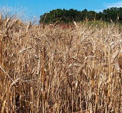
Excluding a semi-arid area of the southwest used for grazing and the area in the east and central portion used for mixed farming and dairying, the land is dedicated to raising hard wheat. Saskatchewan usually produces ⅔s of Canada's wheat. The vast extensions of unbroken plain are well-suited to large-scale mechanized farming. Oats, barley, rye, rapeseed, and flax are also grown throughout the year. The historic process of fur trapping is still practiced.
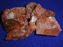
Saskatchewan is rich in minerals. Oil and natural gas found beneath the prairie, prove to be one of the province's most important minerals. The area north of Lake Athabaska has been exploited for ores yielding uranium. The Flin Flon greenstone belt, a Paleoproterozoic greenstone belt around Flin Flon, in the northeast, is mined for copper, gold, and zinc. In the southwest, coal is mined. Potash mining began in the 1950s near Saskatoon and Esterhazy, and Canada is currently a leading producer of the mineral. The majority of the province's industries process raw materials.
Additional information
- Motto: Multis E Gentibus Vires (From many peoples strength)
- Saskatchewan is Canada’s fifth-largest province and has 44% of Canada’s farmland.
- Saskatchewan’s land mass is nearly 1/3 Precambrian rock; 1/3 agricultural land; 23% commercial forest and 12% lakes and rivers
- Shield: authorized by Royal Warrant of King Edward VII, 25 August 1906
- Coat of Arms: This is a crest, supporters, and motto was officially added to the Shield of Arms on 16 September 1986. It is an augmentation of the original Shield of Arms adopted by Royal Warrant of King Edward VII in 1906. It has a lion and a deer on it. The shield displays the royal lion and the three gold sheaves, that symbolize Saskatchewan agriculture.
- Flag: The green upper half represents the northern, the largely forested area of the province; the gold on the lower half represents the southern, the largely grain growing area. The flag is formally adopted in 1969.
- The state flower is a western red lily, lilium philadelphicum var. andinum, selected 1941
- The state bird is sharp-tailed grouse, pedioectes phasianellus jamesi, chosen in 1945.
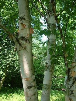
- The state tree is white birch, betula papyrifera; chosen in 1988
- Mammal: White-tailed deer, Odocoileus virginianus, selected in 1988
- Provincial colours: green and gold
- Weather
- Coldest recorded temperature: -57 °C at Prince Albert, 1 February 1893
- Hottest recorded temperature: 45 °C at Yellow Grass and Midale, 5 July 1937
- Average annual percentage of daylight with bright sunshine: 53.3
- Highest number of hours, bright sunshine: 2,701 at Estevan, 1980
See also
- The Saskatchewan Act
- Monarchy in Saskatchewan
- District of Assiniboia
- List of cities in Canada
- List of airports in Saskatchewan
- List of Saskatchewan general elections
- List of Saskatchewan lieutenant-governors
- List of Saskatchewan premiers
- List of Leaders of the Opposition in Saskatchewan
- List of communities in Saskatchewan
- List of Canadian provincial and territorial symbols
- List of Saskatchewan rivers
- Legislative Assembly of Saskatchewan
- List of rural municipalities in Saskatchewan
- Saskatchewan Film and Video Classification Board
- Scouting in Saskatchewan
References
- ↑ 1.00 1.01 1.02 1.03 1.04 1.05 1.06 1.07 1.08 1.09 1.10 1.11 1.12 "Answers.com on Saskatchewan". Retrieved on 2006-12-03.
- ↑ The New World Atlas and Gazetteer 1922 Edition Province of Saskatchewan. Physical and Commercial Analysis of the Dominion of Canada: URL accessed 2007-04-08
- ↑ Saskatchewan CanadaURL accessed 2007-04-04
- ↑ [Agriculture in Canada]
- ↑ 5.0 5.1 5.2 5.3 5.4 "Saskatchewan climate can be described as temperate in the south and with cold winters in the north". Retrieved on 2006-12-03.
- ↑ 6.0 6.1 6.2 6.3 "Saskatchewan geography". Retrieved on 2006-12-03.
- ↑ Statistics Canada 2006 Community ProfilesURL accessed 2007-04-04
- ↑ Statistics Canada 2006 Community ProfilesURL accessed 2007-04-04
- ↑ Richards, J.H., Fung, K.I.. Atlas of Saskatchewan. ed.. Physical Features of Saskatchewan. University of Saskatchewan 1969. pp. p.40.
- ↑ 1926 Highway Map: Province of Saskatchewan URL accessed 2007-04-08
- ↑ Land and Freshwater area by province RL accessed April 5, 2007
- ↑ Last Mountain Lake National Wildlife Area (LML NWA) URL accessed 2007-04-08
- ↑ Katepwa Point Provincial ParkURL accessed 2007-04-08
- ↑ Moose Mountain Provincial ParkURL accessed 2007-04-08
- ↑ Fishing Lake Regional ParkURL accessed 2007-04-08
- ↑ Meota Regional parkURL accessed 2007-04-08
- ↑ Macklin Lake Regional ParkURL accessed 2007-04-08
- ↑ Duck Mountain Provincial ParkURL accessed 2007-04-08
- ↑ Saltcoats Regional ParkURL accessed 2007-04-08
- ↑ Sask Biz Community Profiles Geography URL accessed 2007-04-08
- ↑ Manitou Lake (A Division of Suffern Lake) Regional Park URL accessed 2007-04-08
- ↑ York Lake Regional Park URL accessed 2007-04-08
- ↑ Lake of the Healing WatersURL accessed 2007-04-08
- ↑ Lake Provincial Park , Candle Lake SK, Canada URL accessed 2007-04-08
- ↑ 1926 Highway Map: Province of Saskatchewan (1926) SASKATCHEWAN'S BEAUTIFUL LAKESURL accessed 2007-04-08
- ↑ Land and Freshwater area by province URL accessed April 5, 2007
- ↑ List of National Parks of CanadaURL accessed April 5, 2007
- ↑ SASKATCHEWAN MOSQUITOES AND WEST NILE VIRUSURL accessed April 6, 2007
- ↑ Érudit GPQ v57 n2-3 2003 : Hills : Helmeted Muskox URL accessed April 6, 2007
- ↑ 1926 Highway Map: Province of SaskatchewanURL accessed April 6, 2007
- ↑ Minerals and Mining Statistics On-Line - Mineral Production of Canada, by Province and TerritoryURL accessed 2007-04-04
- ↑ 32.00 32.01 32.02 32.03 32.04 32.05 32.06 32.07 32.08 32.09 32.10 32.11 32.12 32.13 32.14 32.15 32.16 32.17 32.18 32.19 32.20 32.21 32.22 32.23 32.24 32.25 32.26 "Agriculture census". Retrieved on 2006-12-03.
- ↑ 1926 Highway Map: Province of Saskatchewan URL accessed 2007-04-08
|
|||||||||||
|
||||||||||||||