Geography of Puerto Rico
| Native name: Borinquen Sobriquet: Isle of Enchantment Isla del Encanto |
|
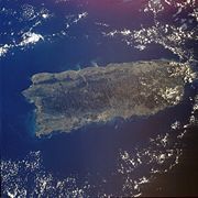 Satellite photo of Puerto Rico |
|
| Geography | |
|---|---|
 |
|
| Location | Caribbean Sea |
| Archipelago | Greater Antilles |
| Area | 9,104 km2 (3,515 sq mi) |
| Length | 170 km (110 mi) |
| Width | 60 km (37 mi) |
| Coastline | 501 km (311 mi) |
| Highest point | Cerro de Punta (1,338 m (4,390 ft)) |
| Country | |
| Territory | |
| Largest city | San Juan (434,374) |
| Demographics | |
| Population | 3,994,259 (as of 2007) |
| Density | 438.74 people/km2 |
| Ethnic groups | White 80.5%, Mulatto 10.9%, Black 8.0%, Amerindian 0.4%, Asian 0.2% |
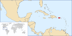
The geography of Puerto Rico describes an archipelago located between the Caribbean Sea and the North Atlantic Ocean, east of the Dominican Republic and west of the Virgin Islands. The main island of Puerto Rico is the smallest and most eastern of the Greater Antilles. With an area of 3,515 square miles (9,104 km²), it is the third largest island in the United States and the 82nd largest island in the world. Various smaller islands and cays, including Vieques, Culebra, Mona, Desecheo, and Caja de Muertos comprise the remainder of the archipelago with only Culebra and Vieques being inhabited year-round. Mona is uninhabited through large parts of the year except for employees of the Puerto Rico Department of Natural Resources.
- See also: List of islands of Puerto Rico
The mainland measures some 100 miles (160 km) by 35 nautical miles (65 km) (170 km by 60 km), an area slightly less than three times the size of Rhode Island, U.S.A.. It is mostly mountainous with large coastal areas in the north and south regions of the island. Some beautiful beaches on the north-west side of the island are Jobos Beach, Maria's Beach, Domes Beach and Sandy Beach. The main mountainous range is called La Cordillera Central (The Central Range). The highest elevation point of Puerto Rico, Cerro de Punta (4,390 ft; 1,338 m),[1] is located in this range. Another important peak is El Yunque, located in the Sierra de Luquillo Mountains at the Caribbean National Forest, with a maximum elevation of 3,494 feet (1,065 m). The capital, San Juan, is located on the main island's north coast.
Contents |
Physical geography
The archipelago of Puerto Rico is located between the Caribbean Sea and the North Atlantic Ocean, east of the Dominican Republic and west of the Virgin Islands. Located in the northeastern Caribbean Sea, Puerto Rico was key to the Spanish Empire since the early years of exploration, conquest and colonization of the New World.

The topography of the main island is divided into three major regions: the mountainous region, which includes the Cordillera Central, Sierra de Luquillo Mountains, Sierra de Cayey and Sierra Bermeja, the coastal plains and the northern karst region. The Cordillera Central extends through the entire island, dividing it into the northern and southern region. The mountain region accounts for approximately 60% of the land area.
The archipelago of Culebra, located east of Puerto Rico, north of Vieques, and west of the Virgin Islands, is composed of the main island of Culebra and 28 uninhabited islets.[2] Mainly mountainous, the island of Culebra possesses renowned beaches.
Climate
Located in the tropics, Puerto Rico enjoys an average temperature of 26 °C (80 °F) throughout the year. The seasons do not change very drastically. The temperature in the south is usually a few degrees higher than the north and temperatures in the central interior mountains are always cooler than the rest of the island. The dry season spans from November to May while the wet season coincides with the Atlantic hurricane season from June to November.
Rivers and lakes
Puerto Rico has 17 lakes (none of them natural)[3] and more than 50 rivers. Most of these rivers are born in the Cordillera Central, Puerto Rico's principal mountain range located across the center of the island. The rivers in the north of the island are bigger and with higher flow capacity than those of the south. The south is thus drier and hotter than the north.
Flora and fauna
As of 1998,[4] 239 plants, 16 birds and 39 amphibians/reptiles have been discovered that are endemic to the archipelago of Puerto Rico. The majority of these (234, 12 and 33 repectively) are found on the main island. The most recognizable endemic species and a symbol of Puerto Rican pride is the Coquí, a small frog easily recognized by the sound from which it gets its name. The Caribbean National Forest, a tropical rainforest is home to the majority (13 of 16) of species of coquí. It is also home to more than 240 plants, 26 of which are endemic and 50 bird species, including one of the top 10 endangered birds in the world, the Puerto Rican Amazon.
Geology
Puerto Rico is composed of Cretaceous to Eocene volcanic and plutonic rocks, which are overlain by younger Oligocene to recent carbonates and other sedimentary rocks. Most of the caverns and karst topography on the island occurs in the northern Oligocene to recent carbonates. The oldest rocks are approximately 190 million years old (Jurassic) and are located at Sierra Bermeja in the southwest part of the island. These rocks may represent part of the oceanic crust and are believed to come from the Pacific Ocean realm. Puerto Rico lies at the boundary between the Caribbean and North American plates. This means that it is currently being deformed by the tectonic stresses caused by the interaction of these plates. These stresses may cause earthquakes and tsunamis. These seismic events, along with landslides, represent some of the most dangerous geologic hazards in the island and in the northeastern Caribbean. The most recent major earthquake occurred on October 11, 1918 and had an estimated magnitude of 7.5 on the Richter scale. It originated off the coast of Aguadilla and was accompanied by a tsunami.
Lying about 120 km (75 miles) north of Puerto Rico in the Atlantic Ocean at the boundary between the Caribbean and North American plates is the Puerto Rico Trench, the largest and deepest trench in the Atlantic. The trench is 1,754 km (1,090 miles) long and about 97 km (60 miles) wide. At its deepest point, named Milwaukee Depth, it is 8,380 m (27,493 ft) deep, or about 8.38 km (5.2 miles).
Political geography

As an unincorporated territory of the United States, Puerto Rico does not have any first-order administrative divisions as defined by the U.S. Government, but there are 78 municipalities at the second level. Municipalities are further subdivided into barrios, and those into sectors. Each municipality has a mayor and a municipal legislature elected for a 4 year term.
The first municipality (previously called "town") of Puerto Rico, San Juan, was founded in 1521. In the 16th century two more municipalities were established, Coamo (1570) and San Germán (1570). Three more municipalities were established in the 17th century. These were Arecibo (1614), Aguada (1692) and Ponce (1692). The 18th and 19th century saw an increase in settlement in Puerto Rico with 30 municipalities being established in the 18th century and 34 more in the 19th century. Only six municipalities were founded in the 20th century with the last, Florida, being founded in 1971.[5]
References
- ↑ "Elevations and Distances in the United States". U.S Geological Survey (29 April 2005). Retrieved on 2006-11-09.
- ↑ "ISLAND, county CULEBRA, state PR". Lat-Long.com. Retrieved on 2006-07-13.
- ↑ Los Lagos de Puerto Rico (Spanish)
- ↑ Island Directory.
- ↑ LinktoPR.com - Fundación de los Pueblos (Spanish).
|
||||||||||||||
