Geography of Moldova
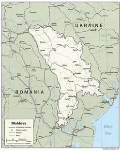

Located in southeastern Europe, Moldova is bordered on the west by Romania and on the north, south, and east by Ukraine. Most of its territory lies between the area's two main rivers, the Dniester and the Prut. The Dniester forms a small part of Moldova's border with Ukraine in the northeast, but it mainly flows through the eastern part of the country, separating Bessarabia and Transnistria. The Prut River forms Moldova's entire western boundary with Romania. The Danube touches the Moldovan border at its southernmost tip, and forms the border for less than 1 km.
It is the second-smallest of the former Soviet republics and the most densely populated. Moldova's economy resembles those of the Central Asian republics, rather than those of the other states on the western edge of the former Soviet Union.
Contents |
Basic data
Location: Eastern Europe, northeast of Romania
Map references: Commonwealth of Independent States
Area:
total: 33,843 km²
land: 33,371 km²
water: 472 km²
Area - comparative: slightly larger than Maryland, United States
Land boundaries:
total: 1,389 km
border countries: Romania 450 km, Ukraine 939 km
Coastline: 0 km (landlocked)
Maritime claims: none (landlocked)
Natural resources: lignite, phosphorites, gypsum, arable land
Land use:
arable land: 53%
permanent crops: 14%
permanent pastures: 13%
forests and woodland: 13%
other: 7% (1993 est.)
Irrigated land: 3,110 km² (1993 est.)
Natural hazards: landslides (57 cases in 1998)
Extreme points:
- The lowest point: Nistru river –2m
- The highest point – Bălăneşti, hill –430m
- North extreme: Naslavcea
- South extreme: Giurgiuleşti
- West extreme: Criva
- East extreme: Palanca
Climate
Moldova's proximity to the Black Sea gives it a mild and sunny climate.
Moldova's climate is moderately continental: the summers are warm and long, with temperatures averaging about 20°C, and the winters are relatively mild and dry, with January temperatures averaging -4°C. Annual rainfall, which ranges from around 600 millimeters in the north to 400 millimeters in the south, can vary greatly; long dry spells are not unusual. The heaviest rainfall occurs in early summer and again in October; heavy showers and thunderstorms are common. Because of the irregular terrain, heavy summer rains often cause erosion and river silting.
Topography
Most of Moldova's territory is a hilly plain cut deeply by many streams and rivers. Geologically, Moldova lies primarily on deep sedimentary rock that gives way to harder crystalline outcroppings only in the north. Leaving the territory of Moldova to the west and north-west, these hills shortly reach the foothills of the Carpathian Mountains, where there are higher elevations.
The northern landscape of Moldova is characterized by gently rolling uplands (up to just over 300 meters or 1000 feet in elevation) interlaced with small flat plains in the valleys of the creeks and rivers (at 150 meters or 500-foot elevation). The Northern Moldova Plateau (Platoul Moldovei de Nord) has an average altitude of 240 meters and a maximum altitude of 320 meters. The Bălţi Plateau (Platoul Bălţi) has an average of 200 meters and a maximum altitude of 250 meters. Originally forested, it has been extensively de-forested for agriculture during the 19th and 20th centuries. In contrast to the region to its south, Bălţi Plateau is sometimes referred to as the Bălţi Plain, although it has relief very different from that of a true plain and vegetation different from that of the steppe.
The uplands of central Moldova, the Codri Hills or Codri Plateau (Podişul Codrilor, in Romanian; Кодры/Kodry, in Russian), at an average elevation of about 350 to 400 meters (1150–1300 feet), are ridges interlaced by deep, flat valleys, ravines, and landslide-scoured depressions. Steep forest-clad slopes account for much of the terrain, where the most common trees are hornbeam, oak, linden, maple, wild pear, and wild cherry. The term Codri refers generally to the forests between the Carpathians and the Dniester river, yet since in Moldova most of them were preserved in the central part, Codri sometimes can also refer to the remaining forests in the hills west and north of Chişinău.
The country's highest point, Bălăneşti Hill, which reaches 1407 feet (429 m) or 1410 feet (430 m), depending on the source, is situated in the Corneşti Hills, the western part of the central region. Northwest of these are the Ciuluc uplands (average 250 meters, max 388 meters). The Dniester uplands (average 250 meters, max 347 meters), their eastern slopes forming the high right bank of the Dniester River, transition into or (if separated by the river Răut) border the northern plateau and central uplands on the east and northeast.
In the south, the Tigheci Hills (average 200 meters, max 301 meters), running to the south almost parallel to the river Prut, are a prolongation of the central hills. To the south (and Tigheci to the east) the hills gradually vanish into the extensive Budjak Plain (Bugeac in Romanian), (average 150-200 meters, max 250 meters), which has numerous ravines and gullies, with most of the Budjak region already in Ukraine.
Transnistria (the left bank of the Dniester) has spurs of the Volhynia-Podolian Upland (Podisul Podoliei, in Romanian; Volyno-Podil's'ka vysochyna, in Ukrainian), (average 180, max 275 meters), which are cut into by tributaries of the Dniester River. The high right bank and low left bank of the Dniester are in sharp contrast here, where visibility is not impeded by forests. The southern half of Transnistria, the Lower Dniester Plain, can be regarded as the western end of the Eurasian steppe, and has an average elevation of 100 meters, with a maximum of 170 meters.
About 75 percent of Moldova is covered by a soil type called "black earth" or chernozem. In the northern highlands, more clay textured soils are found; in the south, red-earth soil is predominant. The soil becomes less fertile toward the south but can still support grape and sunflower production. The uplands have woodland soils, while a small portion in southern Moldova is in the steppe zone, although most steppe areas today are cultivated. The lower reaches of the Prut and Dniester Rivers and the southern river valleys are saline marshes.
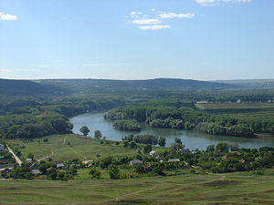
Drainage in Moldova is to the south, toward the Black Sea lowlands, and eventually into the Black Sea, but only eight rivers extend more than 100 kilometers. Moldova's main river, the Dniester, is navigable throughout almost the entire country, and in warmer winters it does not freeze over. The Prut River is a tributary of the Danube River, which it joins at the far southwestern tip of the country. Over 95% of the water circulation in Moldova flows into one of the two rivers - the Prut or Dniester. Of Moldova's well-developed network of about 3,000 creeks and streams, all draining south to the Black Sea, only 246 exceed 6 miles (10 kilometres) in length, and only 8 exceed 60 miles (100 km).
Underground water, extensively used for the republic's water supply, includes about 2,200 natural springs. The terrain favours construction of reservoirs.
Elevation extremes:
lowest point: an unnamed point on the bank of the Dniester River 2 m
highest point: Dealul Bălăneşti 430 m
Natural habitat
Moldova's natural habitat is characterized by forest steppes, a temperate-climate habitat type composed of grassland interspersed with areas of woodland or forest. A belt of forest steppes cross Eurasia from eastern Europe to Eastern Siberia, forming a transition between temperate broadleaf and mixed forests and temperate grasslands. In the 19th century Moldova witnessed a sharp decrease in the forested areas, sacrificed for agriculture due to rich soil.
| habitat region[1] | area, km² | of which currently forests, km² | % forests | habitat type |
|---|---|---|---|---|
| Northern Moldavia | 4,630 | 476 | 10.3% | forest steppe |
| Middle Prut | 2,930 | 312 | 10.6% | forest steppe |
| Bālţi | 1,920 | 51 | 2.7% | steppe |
| Ciuluc-Soloneţ | 1,690 | 169 | 10.0% | forest steppe |
| Dniester-Rāut | 2,480 | 363 | 14.6% | forest steppe |
| Middle Dniester | 1,920 | 175 | 9.1% | forest steppe |
| Codru | 4,740 | 1,300 | 27.5% | forest |
| Lower Prut | 1,810 | 144 | 8.0% | forest steppe |
| South Moldavia | 3,550 | 533 | 15.0% | forest steppe |
| Bugeac | 3,210 | 195 | 6.1% | steppe |
| Lower Dniester 1 | 3,040 | 371 | 12.2% | forest steppe |
| Lower Dniester 2 | 1,920 | 140 | 7.3% | steppe |
| Total | 33,840 | 4,228 | 12,5% | forest steppe |
Environment
Historical references
In the 5th century B.C., Herodotus visited the countryside between two rivers Dnister and Prut, and described these places as a plain with deep chernozem, reach in grass and well irrigated.
Lithuanian Prince Jogaila spoke of Moldova as a rich and fructiferous country. According to Venetian Mateus de Murano, the country was very well located, rich with cattle and all kinds of fruits, pastures are perfect.
The natural resources of the Bălţi steppe always attracted nomads, often forcing the indigenous inhabitants of the steppe to flee. Flemish knight and traveller Guillebert de Lannoy, who visited these places in 1421, mentioned the insignificant population of the region and almost total absence of forests: we moved through large deserts.
In the mid-16th century, a counsellor of Lithuanian Duke George Reichersdorf also complained of travel through the empty, uninhabited lands. He produced the first geographical map of the region including the Moldavian Principality (1541) with rivers Dnister and Prut, cities and other localities. A map of Moldavian Principality was also produced by German diplomat Sigismund von Herberstein, which shows also the geographic areas of Moldavia.
In the 17th century, pilgrims Paul of Aleppo (Syrian deacon) and Ioann Lukianov (Russian priest) traveled on their way to Holy land through Moldavai. The travelers were stricken by the disastrous state of the land that used to blossom: (from old Russian) It better be not ravaged, as no other such can be found, it may yield any kind.
English traveller John Bell, who also visited Moldavia, wrote about fecund soils and small nice towns - speaking of Bălţi and other localities situated next to Răut.
Russian geographer Erik Laxman described Moldavia in the 19th century: To the north is located a plain with almost no trees at all. To the north-west the plain is not as woodless.
Scientist Konstantin Arsenyev mentioned that the north of Bessarabia is a genuine mix of arid steppes, with most fertile pastures, rich meadows and gardens.
Travelers and scientists were amazed by the contrast between rich natiral resources of Moldavia, and its pitiful state of agriculture, poverty of local population.
Quotes
- Moldavian fields, as described by both ancient and contemporary writers, are great in their fertility, by far surpassing the richess of the mountains - "Description of Moldavia", by Dimitrie Cantemir
- Will someone describe Bessarabian steppes, indeed, they do merit a description. However, for this, one needs the talent of unforgettable Gogol, who has so beautifully depicted us the steppes of his homeland. And Bessarabian steppes are not less beautiful. - by Constantin Stamati-Ciurea
Current issues
Moldova's communist-era environmental legacy, like that of many other former Soviet republics, is one of environmental degradation. Agricultural practices such as overuse of pesticides and artificial fertilizers were intended to increase agricultural output at all costs, without regard for the consequences. As a result, Moldova's soil and groundwater were contaminated by lingering chemicals, some of which (including DDT) have been banned in the West.
Such practices continue in Moldova to the present day. In the early 1990s, use of pesticides in Moldova averaged approximately twenty times that of other former Soviet republics and Western nations. In addition, poor farming methods, such as destroying forests to plant vineyards, have contributed to the extensive soil erosion to which the country's rugged topography is already prone.
International environmental agreements
party to: Air Pollution, Biodiversity, Climate Change, Desertification, Hazardous Wastes, Ozone Layer Protection
signed, but not ratified: Air Pollution-Persistent Organic Pollutants
See also
- Moldova
- List of cities in Moldova
Notes
External links
|
|||||||||||
|
|||||||||||||||||