Geography of India
| Geography of India | |
|---|---|
 |
|
| Continent | Asia |
| Region | Southern Asia Indian subcontinent |
| Coordinates | 20°00'N 77°00'E |
| Area | Ranked 7th 3,287,263 km² (1,269,219.3 sq mi) 90.44% land 9.56 % water |
| Borders | Total land borders:[1] 15,106.70 km (9,387 mi) Bangladesh: 4,096.70 km (2,546 mi) China (PRC): 3,488 km (2,167 mi) Pakistan: 3,323 km (2,065 mi) Nepal: 1,751 km (1,088 mi) Myanmar: 1,643 km (1,021 mi) Bhutan: 699 km (434 mi) Afghanistan: 106 km (66 mi) |
| Highest point | K2[2] 8,611 m (28,251 ft) |
| Lowest point | Kuttanad -2.2 m (−7.2 ft) |
| Longest river | Ganges–Brahmaputra |
| Largest lake | Chilka Lake |
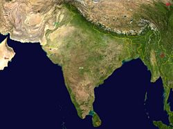
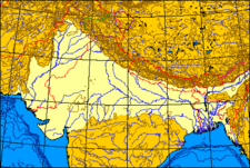
The geography of India comprises most of the Indian subcontinent and is situated on the Indian Plate in the northerly portion of the Indo-Australian Plate. India lies to the north of the equator between 8°4' and 37°6' north latitude and 68°7' and 97°25' east longitude.[3] It is the seventh-largest country in the world, with a total land area of 3,287,263 square kilometres (1,269,219 sq mi).[4] India measures 3,214 km (1,997 mi) from north to south and 2,993 km (1,860 mi) from east to west. It has a land frontier of 15,200 km (9,445 mi) and a coastline of 7,517 km (4,671 mi).[5]
India is bounded to the southwest by the Arabian Sea, to the southeast by the Bay of Bengal and the Indian Ocean to the south. Along its northeastern frontier are the Himalayas, which form India's geographic boundary with the People's Republic of China, Bhutan and Nepal. Cape Comorin constitutes the southern tip of the Indian peninsula, which narrows before ending in the Indian Ocean. The southernmost part of India is Indira Point in the Andaman and Nicobar Islands.[5] The Maldives, Sri Lanka and Indonesia are island nations to the south of India. Sri Lanka is separated from India by a narrow channel of sea formed by Palk Strait and the Gulf of Mannar. The territorial waters of India extend into the sea to a distance of twelve nautical miles (22 km) measured from the appropriate baseline.[6]
The Ganges is the longest river in India and forms the Indo-Gangetic Plain. The Ganges-Brahmaputra system occupies most of northern, central and eastern India, while the Deccan Plateau occupies most of southern India. Along its western frontier is the Thar Desert, which is the seventh-largest in the world.
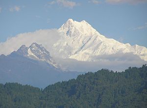
India's highest points are K2 in the disputed region of Kashmir at 8,611 m (28,251 ft), followed by Kanchenjunga in Sikkim at 8,598 m (28,209 ft). Climate across India ranges from equatorial in the far south, to Alpine in the upper reaches of the Himalayas.
Contents |
History
The Indian Plate was originally a part of the ancient continent of Gondwanaland from which it split off, eventually becoming a major plate. In the late Cretaceous Period about 90 million years ago, subsequent to the splitting off from Gondwanaland of conjoined Madagascar and India, the Indian Plate split from Madagascar. It began moving north at about 15 cm/yr (6 in/yr)[7] and began colliding with Asia between 50 and 55 million years ago, in the Eocene epoch of the Cenozoic Era. During this time, the India Plate covered a distance of 2,000 to 3,000 km (1,200 to 1,900 mi), and moved faster than any other known plate. In 2007, German geologists determined that the reason the India Plate moved so quickly is that it is only half as thick as the other plates which formerly constituted Gondwanaland.[8] The collision with the Eurasian Plate along the modern border between India and Nepal formed the orogenic belt that created the Tibetan Plateau and the Himalayas. The India Plate is currently moving northeast at 5 cm/yr (2 in/yr), while the Eurasian Plate is moving north at only 2 cm/yr (0.8 in/yr). India is thus referred to as the "fastest continent."[8] This is causing the Eurasian Plate to deform, and the India Plate to compress at a rate of 4 mm/yr (0.15 in/yr). Modern geographic challenges for India include the drying of rivers and wetlands, erosion of highlands and mountains, desertification, rising sea levels and alterations in the course of rivers.[9]
Political geography
India is divided into twenty-eight states (further subdivided into districts) and seven union territories.
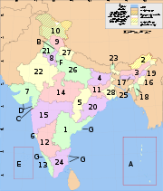
States:
|
Union Territories:

India's borders run a total length of 15,106.70 km (9,387 mi).[1] Its borders with Pakistan and Bangladesh were delineated according to the Radcliffe Line, which was created in 1947 to partition India on religious lines before independence from British rule. Located to its west, Pakistan's border with India runs 3,323 km (2,065 mi), dividing the Punjab region and along the boundaries of the Thar Desert and the Rann of Kutch.[1] Both nations delineated a Line of Control (LoC) to serve as the informal boundary between the Indian and Pakistan-administered areas of Kashmir. According to India's claim, it shares a 106 km (66 mi) border with Afghanistan in northwestern Kashmir, which is under Pakistani control.[1]
India's border with Bangladesh runs 4,096.70 km (2,546 mi).[1] There are 92 enclaves of Bangladesh on Indian soil and 106 enclaves of India are on Bangladeshi soil.[10] The Teen Bigha Corridor is a strip of land formerly belonging to India on the West Bengal–Bangladesh border which has been leased indefinitely to Bangladesh so that it can access its Dehgram–Angalpota enclaves.[11]
The Line of Actual Control (LAC) is the effective border between India and the People's Republic of China. It traverses 4,057 km along the the Indian states of Jammu and Kashmir, Uttarakhand, Himachal Pradesh, Sikkim and Arunachal Pradesh.[12] Both nations claim the Aksai Chin region of northeastern Kashmir, which fell into Chinese control during the Sino-Indian War of 1962. China also claims territory in the Indian state of Arunachal Pradesh. The border with Burma (Myanmar) 1,643 km (1,021 mi) along the southern borders of India's northeastern states. Located amidst the Himalayan range, India's border with Bhutan runs 699 km (434 mi).[1] The border with Nepal runs 1,751 km (1,088 mi) along the foothills of the Himalayas in northern India.[1] The Siliguri Corridor, narrowed sharply by the borders of Bhutan, Nepal and Bangladesh, connects peninsular India with the northeastern states.
Physiographic regions
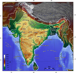
India is divided into seven physiographic regions. They are
- The northern mountains including the Himalayas, which includes the Kuen Lun and the Karakoram ranges and the northeast mountain ranges.
- Indo-Gangetic plains
- Thar Desert
- Central Highlands and Deccan Plateau
- East Coast
- West Coast
- Bordering seas and islands[5]
Mountains

A great arc of mountains, composed of the Himalaya, Hindu Kush, and Patkai ranges define the northern Indian subcontinent. They were formed by the ongoing tectonic collision of the Indian Plate with the Eurasian Plate that started some 50 million years ago. These include some of the world's tallest mountains and act as a natural barrier to cold polar winds. They also facilitate the monsoons winds drive climate in India. Rivers that originate in these mountains water the fertile Indo-Gangetic plains. These mountains are recognised by biogeographers as the boundary between two of the earth's great ecozones; the temperate Palearctic that covers most of Eurasia and the tropical and subtropical Indomalaya ecozone that includes the Indian subcontinent, Southeast Asia and Indonesia.
India has eight major mountain ranges having peaks of over 1,000 m (3,281 ft):
- The Himalaya is the world's highest mountain range.[13] They form India's northeastern border, separating it from northeastern Asia. They are one of the world's youngest mountain ranges and extend almost uninterrupted for 2,500 m (8,202 ft), covering an area of 500,000 km2 (193,051 sq mi).[13] The Himalayas extend from Jammu and Kashmir in the west to Arunachal Pradesh in the east. These states along with Himachal Pradesh, Uttarakhand, and Sikkim lie mostly in the Himalayan region. Some of the Himalayan peaks range over 7,000 m (22,966 ft) and the snow line ranges between 6,000 m (19,685 ft) in Sikkim to around 3,000 m (9,843 ft) in Kashmir. Kangchenjunga, which lies on the Sikkim–Nepal border, is the highest point in the area administered by India. Most peaks in the Himalayas remain snowbound throughout the year. The lowest was −45 °C (−49 °F) in Kashmir. The Himalayas act as a barrier to the frigid katabatic winds flowing down from Central Asia. Thus, North India is kept warm or only mildly cooled during winter; in summer, the same phenomenon makes India relatively hot. The Shiwalik, or lower Himalaya, consists of smaller hills towards the Indian side. Most of the rock formations are young and highly unstable, with landslides being a regular phenomenon during the rainy season. Many of India's hill stations are located on this range. The climate varies from subtropical in the foothills to alpine at the higher elevations of these mountain ranges. According to earthquake hazard zoning of India, tectonic plates beneath the earth's surface are responsible for yearly earthquakes along the Himalayan belt and in northeast India. This is a high-risk area, classified as Zone V.
- The Karakoram is situated in the disputed region of Kashmir. It has more than sixty peaks above 7,000m (22,960 ft), including K2, the second highest peak in the world (8,611 m, 28,251 ft). K2 is just 237 m smaller than the 8,848 m tall Mount Everest. The range is about 500 km (300 mi) in length and is the most heavily glaciated part of the world outside of the polar regions. The Siachen Glacier at 70 km and the Biafo Glacier at 63 km rank as the world's second and third-longest glaciers outside the polar regions.[14] It is bounded in the northeast by the edge of the Tibetan Plateau and on the north by the Wakhan Corridor and the Pamir Mountains. Just to the west of the northwest end of the Karakoram lies the Hindu Raj range, beyond which is the Hindu Kush range. The southern boundary of the Karakoram is formed by the Gilgit, Indus and Shyok rivers, which separate the range from the northwestern end of the Himalayas.
- The Patkai, or Purvanchal, are situated near India's eastern border with Myanmar. They were created by the same tectonic processes that led to the formation of the Himalaya. The features of the Patkai mountains are conical peaks, steep slopes and deep valleys. The Patkai ranges are not as rugged or tall as the Himalayas. There are three hill ranges that come under the Patkai: the Patkai-Bum, the Garo–Khasi–Jaintia and the Lushai hills. The Garo–Khasi range is in Meghalaya. Mawsynram, a village near Cherrapunji lying on the windward side of these hills, has the distinction of being the wettest place in the world, receiving the highest annual rainfall.[15]
- The Vindhya range runs across most of central India, extending 1,050 km (652 mi).[13] The average elevation of these hills is 3,000 m (9,843 ft).[13] They are believed to have been formed by the wastes created by the weathering of the ancient Aravali mountains. It geographically separates northern India from southern India. The western end of the range lies in eastern Gujarat, near its border with Madhya Pradesh, and runs east and north, almost meeting the Ganges at Mirzapur.
- The Satpura Range begins in eastern Gujarat near the Arabian Sea coast and runs east across Maharashtra, Madhya Pradesh to Chhattisgarh. It extends 900 km (559 mi) with many of its peaks rising above 1,000 m (3,281 ft).[13] It is triangular in shape, with its apex at Ratnapuri and the two sides being parallel to the Tapti and Narmada rivers.[16] It runs parallel to the Vindhya Range, which lies to the north, and these two east-west ranges divide the Indo-Gangetic plain from the Deccan Plateau. Located north of River Narmada.
- The Aravali Range is the oldest mountain range in India, running from northeast to southwest across Rajasthan in western India, extending approximately 500 km (311 mi). The northern end of the range continues as isolated hills and rocky ridges into Haryana, ending near Delhi. The highest peak is Mount Abu, rising to 1,722 m (5,650 ft), lying near the southwestern extremity of the range, close to the border with Gujarat. The Aravali Range is the eroded stub of an ancient folded mountain system that was once snow-capped. The range rose in a Precambrian event called the Aravali-Delhi orogen. The range joins two of the ancient segments that make up the Indian craton, the Marwar segment to the northwest of the range, and the Bundelkhand segment to the southeast.

- The Western Ghats or Sahyadri mountains run along the western edge of India's Deccan Plateau and separate it from a narrow coastal plain along the Arabian Sea. The range runs approximately 1,600 km (994 mi)[16] from south of the Tapti River near the Gujarat–Maharashtra border and across Maharashtra, Goa, Karnataka, Kerala and Tamil Nadu to the southern tip of the peninsula. The average elevation is around 1,000 m (3,281 ft).[16] The Anai Mudi in the Anaimalai Hills at 2,695 m (8,842 ft) in Kerala is the highest peak in the Western Ghats.
- The Eastern Ghats are a discontinuous range of mountains, which have been eroded and vivisected by the four major rivers of southern India, the Godavari, Mahanadi, Krishna, and Kaveri. These mountains run from West Bengal to Orissa, Andhra Pradesh and Tamil Nadu, along the coast and parallel to the Bay of Bengal. Though not as tall as the Western Ghats, some of its peaks are over 1,000 m (3,281 ft) in height.[16] The Nilgiri hills in Tamil Nadu are the junction of the Eastern and Western Ghats.
Indo-Gangetic plain
The Indo-Gangetic plains, also known as the "Great Plains," are large floodplains of the Indus and the Ganga-Brahmaputra river systems. They run parallel to the Himalaya mountains, from Jammu and Kashmir in the west to Assam in the east and draining most of northern and eastern India. The plains encompass an area of 700,000 km² (270,000 mile²) and vary in width through their length by several hundred kilometres. The major rivers of this system are the Ganga (Ganges) and the Indus along with their tributaries; Beas, Yamuna, Gomti, Ravi, Chambal, Sutlej and Chenab.
The great plains are sometimes classified into four divisions:
- The Bhabar belt — is adjacent to the foothills of the Himalayas and consists of boulders and pebbles which have been carried down by the river streams. As the porosity of this belt is very high, the streams flow underground. The bhabar is generally narrow about 7-15 km wide.
- The Terai belt — lies next to the Bhabar region and is composed of newer alluvium. The underground streams reappear in this region. The region is excessively moist and thickly forested. It also receives heavy rainfall throughout the year and is populated with a variety of wildlife.
- The Bangar belt — consists of older alluvium and forms the alluvial terrace of the flood plains. In the Gangetic plains, it has a low upland covered by laterite deposits.
- The Khadar belt — lies in lowland areas after the Bangar belt. It is made up of fresh newer alluvium which is deposited by the rivers flowing down the plain.
The Indo-Gangetic belt is the world's most extensive expanse of uninterrupted alluvium formed by the deposition of silt by the numerous rivers. The plains are flat and mostly treeless, making it conducive for irrigation through canals. The area is also rich in ground water sources.
The plains are one of the world's most intensely farmed areas. The main crops grown are rice and wheat, which are grown in rotation. Others include maize, sugarcane and cotton. The Indo-Gangetic plains rank among the world's most densely populated areas.
Thar Desert
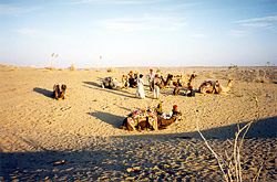
The Thar Desert (also known as the Great Indian Desert) is world's seventh largest desert;[17] it forms a significant portion of western India and covers an area of 238,700 km² (92,200 mile²).[17] The desert continues into Pakistan as the Cholistan Desert. Most of the Thar Desert is situated in Rajasthan, covering 61% of its geographic area.
About 10 percent of this ecoregion is composed of sand dunes, and the other 90 percent of craggy rock forms, compacted salt-lake bottoms, and interdunal and fixed dune areas. Annual temperatures can range from near-freezing in the winter to more than 50(C during the summer. All rainfall is associated with the short July-September southwest monsoon that brings a mere 100-500 mm of precipitation. Water is scarce and occurs at great depths, from 30 to 120 m below the ground level.[18] Rainfall is precarious and erratic, ranging from below 120 mm (4.72 inches) in the extreme west to 375 mm (14.75 inches) eastward. The soils of the arid region are generally sandy to sandy-loam in texture. The consistency and depth vary according to the topographical features. The low-lying loams are heavier and may have a hard pan of clay, calcium carbonate or gypsum. Because of the low population density, the effect of the population on the environment is relatively less compared to the rest of India.
Highlands
The Central Highlands are composed of three main plateaus — the Malwa Plateau in the west, the Deccan Plateau in the south (covering most of the Indian peninsula) and the Chota Nagpur Plateau in the east.
The Malwa Plateau is located in Rajasthan, Madhya Pradesh and Gujarat. The average elevation of the Malwa plateau is 500 metres, and the landscape generally slopes towards the north. Most of the region is drained by the Chambal River and its tributaries; the western part is drained by the upper reaches of the Mahi River.

The Deccan Plateau is a large triangular plateau, bounded by the Vindhyas to the north and flanked by the Eastern and Western Ghats. The Deccan covers a total area of 1.9 million km² (735,000 mile²). It is mostly flat, with elevations ranging from 300 to 600 m (1,000 to 2,000 ft). The average elevation of the plateau is 2,000 feet (600 m) above sea level. The surface slopes from 3,000 feet (900 m) in the west to 1,500 feet (450 m) in the east.[19] It slopes gently from west to east and gives rise to several peninsular rivers such as the Godavari, the Krishna, the Kaveri and the Narmada, which drain into the Bay of Bengal. This region is mostly semi-arid as it lies on the leeward side of both Ghats. Much of the Deccan is covered by thorn scrub forest scattered with small regions of deciduous broadleaf forest. Climate in the Deccan ranges from hot summers to mild winters.
The Chota Nagpur Plateau is situated in eastern India, covering much of Jharkhand and adjacent parts of Orissa, Bihar and Chhattisgarh. Its total area is approximately 65,000 km² (25,000 mile²) and is made up of three smaller plateaus — the Ranchi, Hazaribagh, and Kodarma plateaus. The Ranchi plateau is the largest, with an average elevation of 700 m (2,300 ft). Much of the plateau is forested, covered by the Chota Nagpur dry deciduous forests. Vast reserves of metal ores and coal have been found in the Chota Nagpur plateau. The Kathiawar peninsula in western Gujarat is bounded by the Gulf of Kutch and the Gulf of Khambat. The natural vegetation on most of the peninsula is xeric scrub, part of the Northwestern thorn scrub forests ecoregion.
In western India, the Kutch region in Gujarat and Koyna in Maharashtra are classified as a Zone IV region (high risk) for earthquakes. The Kutch city of Bhuj was the epicentre of the 2001 Gujarat earthquake, which claimed the lives of more than 20,000 people and injured 166,836 while destroying or damaging near a million homes.[20] The 1993 Latur earthquake in Maharashtra killed 7,928 people and injured 30,000.[21] Other areas have a moderate to low risk chance of an earthquake occurring.[22]
Coasts
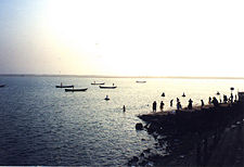
The Eastern Coastal Plain is a wide stretch of land lying between the Eastern Ghats and the Bay of Bengal. It stretches from Tamil Nadu in the south to West Bengal in the north. The Mahanadi, Godavari, Kaveri and Krishna rivers drain these plains and their deltas occupy most of the area. The coastal regions exceed 30 °C (86 °F) coupled with high levels of humidity. The region receives both the northeast and southwest monsoon rains. The southwest monsoon splits into two arms, the Bay of Bengal arm and the Arabian Sea arm. The Bay of Bengal arm moves northwards crossing northeast India in early June. The Arabian Sea arm moves northwards and deposits much of its rain on the windward side of Western Ghats. Annual rainfall averages between 1,000 mm (40 in) and 3,000 mm (120 in). The width of the plains varies between 100 to 130 km (62 to 80 miles).[23] The plains are divided into six regions — the Mahanadi delta, the southern Andhra Pradesh plain, the Krishna-Godavari deltas, the Kanyakumari coast, the Coromandel Coast and sandy coastal.
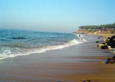
The Western Coastal Plain is a narrow strip of land sandwiched between the Western Ghats and the Arabian Sea, ranging from 50 to 100 km (30 to 60 miles) in width. It extends from Gujarat in the north and through Maharashtra, Goa, Karnataka and Kerala. Numerous rivers and backwaters inundate the region. Originating in the Western Ghats, the rivers are fast-flowing and mostly perennial, leading to the formation of estuaries. Major rivers flowing into the sea are the Tapi, Narmada, Mandovi and Zuari. The coast is divided into the Konkan, which is situated in Maharashtra and Gao; the Kanara in Karnataka and the Malabar Coast in Kerala. Vegetation is mostly decidious, but the Malabar Coast moist forests constitute a unique ecoregion.
Islands

- See also: List of islands of India
The Lakshadweep and the Andaman and Nicobar Islands are India's two major island possessions having the status of union territories. The Lakshadweep islands lie 200 to 300 km (124 to 186 miles) off the coast of Kerala in the Arabian Sea with an area of 28 km² (11 sq mi). They officially consist of 12 atolls, 3 reefs and 5 submerged banks, with a total of about 36 islands and islets. The reefs are in fact also atolls, although mostly submerged, with only small unvegetated sand cays above the high water mark. Indira Point, India's southernmost land point is situated in the Nicobar islands, and lies just 189 km (117 miles) from the Indonesian island of Sumatra to the southeast. The highest point is Mount Thullier at 642 m (2,140 ft).
The Andaman and Nicobar Islands are located between 6o and 14o North latitude and 92o and 94o East longitude.[24] They consist of 572 isles, lying in the Bay of Bengal near the Myanmar coast. It is located 1255 km (780 miles) from Kolkata (Calcutta) and 193 km (120 miles) from Cape Negrais in Myanmar.[24] The territory consists of two island groups, the Andaman Islands and the Nicobar Islands. The Andaman islands number 204 and have a total length of 352 km (220 miles). India's volcanoes lie in the Andaman islands. The Barren Island is an active volcano, having last erupted in May 2005. The Narcondum is a dormant volcano and there is a mud volcano at Baratang.
Significant islands just off the Indian coast include Diu, a former Portuguese enclave; Majuli, Asia's largest freshwater island; Elephanta in the Bombay Harbour; and Sriharikota barrier island in Andhra Pradesh. Salsette Island is India's most populous island on which the city of Mumbai (Bombay) is located. Forty-two islands in the Gulf of Kutch constitute the Marine National Park.
Water bodies
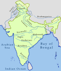
India has about 14,500 km of inland navigable waterways.[25] Twelve of India's rivers are classified as major, with the total catchment area exceeding 2,528,000 km² (976,000 mile²).[16] All major rivers of India originate from one of the three main watersheds:[16]
- The Himalaya and the Karakoram ranges
- Vindhya and Satpura range in central India
- Sahyadri or Western Ghats in western India
The Himalayan river networks are snow-fed and flow throughout the year. The other two networks are dependent on the monsoons and shrink into rivulets during the dry season. The Himalayan rivers that flow westward into Pakistan are the Indus, Beas, Chenab, Ravi, Sutlej, and Jhelum.[26]
The Ganga-Brahmaputra-Meghana system has the largest catchment area of 1,100,000 km² (424,700 mile²).[16] The Ganga originates from the Gangotri Glacier in Uttarakhand.[26] It flows southeast, draining into the Bay of Bengal.[16] The Yamuna and Gomti rivers also arise in the western Himalayas and join the Ganga in the plains.[16] The Brahmaputra, another tributary of the Ganga, originates in Tibet and enters India through the far-eastern state of Arunachal Pradesh. It proceeds westwards, unifying with the Ganga in Bangladesh.[16] The Chambal, another tributary of the Ganga originates from the Vindhya-Satpura watershed. The river flows eastward. Westward-flowing rivers from this watershed are the Narmada and Tapti, which drain into the Arabian Sea in Gujarat. The river network that flows from east to west constitutes 10% of the total outflow.
The Western Ghats are the source of all Deccan rivers, which include the Mahanadi River through the Mahanadi River Delta, Godavari River, Krishna River and Kaveri River, all draining into the Bay of Bengal. These rivers constitute 20% of India's total outflow.[26]
The heavy southwest monsoon rains cause the Brahmaputra and other rivers to distend their banks, often flooding surrounding areas. Though they provide rice paddy farmers with a largely dependable source of natural irrigation and fertilisation, such floods have killed thousands of people and displace millions.
Major gulfs include the Gulf of Cambay, Gulf of Kutch and the Gulf of Mannar. Straits include the Palk Strait, which separates India from Sri Lanka and the Ten Degree Channel, which separates the Andamans from the Nicobar Islands and the Eight Degree Channel, which separates the Laccadive and Amindivi Islands from the Minicoy Island towards the south. Important capes include the Cape Comorin, the southern tip of mainland India; Indira Point, the southernmost location of India; Rama's Bridge and Point Calimere. Arabian Sea is to the west of India. Bay of Bengal is to the eastern side of India while India Ocean is to the south of India. Smaller seas include the Laccadive Sea and the Andaman Sea. There are four coral reefs in India, located in the Andaman and Nicobar Islands, Gulf of Mannar, Lakshadweep and Gulf of Kutch.[22] Important lakes include Chilka Lake, the country's largest saltwater lake in Orissa; Kolleru Lake in Andhra Pradesh; Loktak Lake in Manipur, Dal Lake in Kashmir, Sambhar Lake in Rajasthan and the Sasthamkotta Lake in Kerala.
Wetlands

India's wetland ecosystem is widely distributed from the cold and arid located in the Ladakh region of Jammu and Kashmir, and those with the wet and humid climate of peninsular India. Most of the wetlands are directly or indirectly linked to river networks. The Indian government has identified a total of 71 wetlands for conservation and are part of sanctuaries and national parks.[27] Mangrove forests are present all along the Indian coastline in sheltered estuaries, creeks, backwaters, salt marshes and mudflats. The mangrove area covers a total of 4 461 km² (1,722 mile²),[28] which comprises 7% of the world's total mangrove cover. Prominent mangrove covers are located in the Andaman and Nicobar Islands, the Sundarbans delta, the Gulf of Kutch and the deltas of the Mahanadi, Godavari and Krishna rivers. Parts of Maharashtra, Karnataka and Kerala also have large mangrove covers.[22]
The Sundarbans delta is home to the largest mangrove forest in the world. It lies at the mouth of the Ganges and spreads across areas of Bangladesh and West Bengal. The Sundarbans is a UNESCO World Heritage Site, but is identified separately as the Sundarbans (Bangladesh) and the Sundarbans National Park (India). The Sundarbans are intersected by a complex network of tidal waterways, mudflats and small islands of salt-tolerant mangrove forests. The area is known for its diverse fauna, being home to a large variety of species of birds, spotted deer, crocodiles and snakes. Its most famous inhabitant is the Bengal Tiger. It is estimated that there are now 400 Bengal tigers and about 30,000 spotted deer in the area.
The Rann of Kutch is a marshy region located in northwestern Gujarat and the bordering Sind province of Pakistan. It occupies a total area of 27 900 km² (10,800 mile²).[29] The region was originally a part of the Arabian Sea. Geologic forces such as earthquakes resulted in the damming up of the region, turning it into a large saltwater lagoon. This area gradually filled with silt thus turning it into a seasonal salt marsh. During the monsoons, the area turns into a shallow marsh, often flooding to knee-depth. After the monsoons, the region turns dry and becomes parched.
Climate

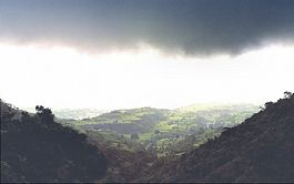
Based on the Köppen system, India hosts six major climatic subtypes, ranging from arid desert in the west, alpine tundra and glaciers in the north, and humid tropical regions supporting rainforests in the southwest and the island territories. Many regions have starkly different microclimates. The nation has four seasons: winter (January–February), summer (March–May), a monsoon (rainy) season (June–September) and a post-monsoon period (October–December).[26]
The Himalayas act as a barrier to the frigid katabatic winds flowing down from Central Asia. Thus, North India is kept warm or only mildly cooled during winter; in summer, the same phenomenon makes India relatively hot. Although the Tropic of Cancer—the boundary between the tropics and subtropics—passes through the middle of India, the whole country is considered to be tropical.
Summer lasts between March and June in most parts of India. Temperatures exceed 40 °C (104 °F) during the day. The coastal regions exceed 30 °C (86 °F) coupled with high levels of humidity. In the Thar desert area temperatures can exceed 45 °C (113 °F). The rain-bearing monsoon clouds are attracted to the low-pressure system created by the Thar Desert. The southwest monsoon splits into two arms, the Bay of Bengal arm and the Arabian Sea arm. The Bay of Bengal arm moves northwards crossing northeast India in early June. The Arabian Sea arm moves northwards and deposits much of its rain on the windward side of Western Ghats. Winters in peninsula India see mild to warm days and cool nights. Further north the temperature is cooler. Temperatures in some parts of the Indian plains sometimes fall below freezing. Most of northern India is plagued by fog during this season. The highest temperature recorded in India was 50.6 °C (123.08 °F) in Alwar in 1955. The lowest was −45 °C (−49 °F) in Kashmir.
Geology

India's geological features are classified based on their era of formation.[30] The Precambrian formations of Cudappah and Vindhyan systems are spread out over the eastern and southern states. A small part of this period is spread over western and central India.[30] The Paleozoic formations from the Cambrian, Ordovician, Silurian and Devonian system are found in the Western Himalaya region in Kashmir and Himachal Pradesh.[30] The Mesozoic Deccan Traps formation is seen over most of the northern Deccan; they are believed to be the result of sub-aerial volcanic activity.[30] The Trap soil is black in colour and conducive to agriculture. The Carboniferous system, Permian System and Triassic systems are seen in the western Himalayas. The Jurassic system is seen in the western Himalayas and Rajasthan.
Tertiary imprints are seen in parts of Manipur, Nagaland, Arunachal Pradesh and along the Himalayan belt. The Cretaceous system is seen in central India in the Vindhyas and part of the Indo-Gangetic plains.[30] The Gondowana system is seen in the Narmada River area in the Vindhyas and Satpuras. The Eocene system is seen in the western Himalayas and Assam. Oligocene formations are seen in Kutch and Assam.[30] The Pleistocene system is found over central India. The Andaman and Nicobar Island are thought to have been formed in this era by volcanoes.[30] The Himalayas were formed by the convergence and deformation of the Indo-Australian and Eurasian Plates. Their continued convergence raises the height of the Himalayas by 1 cm each year.
Soils in India can be classified into 8 categories: alluvial, black, red, laterite, forest, arid & desert, saline & alkaline and peaty & organic soils.[31][32] Alluvial soil constitute the largest soil group in India, constituting 80% of the total land surface.[32] It is derived from the deposition of silt carried by rivers and are found in the Great Northern plains from Punjab to the Assam valley.[32] Alluvial soil are generally fertile but they lack nitrogen and tend to be phosphoric.[32]
Black soil are well developed in the Deccan lava region of Maharashtra, Gujarat, and Madhya Pradesh.[33] These contain high percentage of clay and are moisture retentive.[32] Red soil are found in Tamil Nadu, Karnataka plateau, Andhra plateau, Chota Nagpur plateau and the Aravallis.[33] These are deficient in nitrogen, phosphorus and humus.[32][33] Laterite soils are formed in tropical regions with heavy rainfall. Heavy rainfall results in leaching out all soluble material of top layer of soil. These are generally found in Western ghats, Eastern ghats and hilly areas of northeastern states that receive heavy rainfall. Forest soils occur on the slopes of mountains and hills in Himalayas, Western Ghats and Eastern Ghats. These generally consist of large amounts of dead leaves and other organic matter called humus.
Natural resources
India's total renewable water resources are estimated at 1,907.8 km3/year.[34] Its annual supply of usable and replenshable groundwater amounts to 350 billion cubic metres.[35] Only 35% of groundwater resources are being utilised.[35] About 44 million tonnes of cargo is moved annually through the country's major rivers and waterways.[25] Groundwater supplies 40% of water in India's irrigation canals. 56% of the land is arable and used for agriculture. Black soils are moisture-retentive and are preferred for dry farming and growing cotton, linseed, etc. Forest soils are used for tea and coffee plantations. Red soil have a wide diffusion of iron content.[33]
Most of India's estimated 5.4 billion barrels (860,000,000 m3) in oil reserves are located in the Mumbai High, upper Assam, Cambay, the Krishna-Godavari and Cauvery basins.[36] India possesses about seventeen trillion cubic feet of natural gas in Andhra Pradesh, Gujarat and Orissa.[36] Uranium is mined in Andhra Pradesh. India has 400 medium-to-high enthalpy thermal springs for producing geothermal energy in seven "provinces" — the Himalayas, Sohana, Cambay, the Narmada-Tapti delta, the Godavari delta and the Andaman and Nicobar Islands (specifically the volcanic Barren Island.[37]
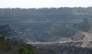
India is the world's biggest producer of mica blocks and mica splittings.[38] India ranks second amongst the world's largest producers of barites and chromites.[38] The Pleistocene system is rich in minerals. India is the third-largest coal producer in the world and ranks fourth in the production of iron ore.[36][38] It is the fifth-largest producer of bauxite and crude steel, the seventh-largest of manganese ore and the eighth-largest of aluminium.[38] India has significant sources of titanium ore, diamonds and limestone.[39] India possesses 24% of the world's known and economically-viable thorium, which is mined along shores of Kerala.[40] Gold had been mined in the now-defunct Kolar Gold Fields in Karnataka.[41]
See also
|
|||||||||||
|
||||||||||||||||||||
|
|||||||
|
|||||||||||
References
- ↑ 1.0 1.1 1.2 1.3 1.4 1.5 1.6 "Ministry of Home Affairs (Department of Border Management)". Ministry of Home Affairs (Department of Border Management). Retrieved on 2008-01-09.
- ↑ India officially regards K2, located in Pakistan Occupied Kashmir as its highest peak.
- ↑ India Yearbook 2007. Publications Division, Ministry of Information & Broadcasting, Govt. Of India. pp. 1. ISBN 81-230-1423-6.
- ↑ "India Details on Official India Government website". Government of India. Retrieved on June 9, 2007.
- ↑ 5.0 5.1 5.2 Manorama Yearbook 2006 (India - The Country)'. Malayala Manorama. 2006. pp. Pg 515.
- ↑ "Territorial extent of India's waters". developments till 1965. THE INTERNATIONAL LAW OF THE SEA AND INDIAN MARITIME LEGISLATION (2005-04-30). Retrieved on 2006-05-16.
- ↑ Bin Zhu et al (PDF). Age of Initiation of the India-Asia Collision in the East-Central Himalaya. Department of Earth and Atmospheric Sciences, University at Albany. pp. 281. http://geosci.uchicago.edu/~rowley/Rowley/Collision_Age_files/J%20Geol%202005%20Zhu.pdf. Retrieved on 2008-11-19.
- ↑ 8.0 8.1 Dr. Rainer Kind (09 2007). The Fastest Continent: India's truncated lithospheric roots. Helmholtz Association of German Research Centres.
- ↑ Augustin Collete et al (PDF). Case Studies on Climate Change and World Heritage. World Heritage Centre, UNESCO. pp. 281. http://whc.unesco.org/documents/publi_climatechange.pdf. Retrieved on 2008-11-19.
- ↑ Naunidhi Kaur (06 2002). "The Nowhere People". Frontline Magazine, The Hindu 19 (12). http://www.hinduonnet.com/fline/fl1912/19120600.htm. Retrieved on 2008-11-19.
- ↑ J.N. Dixit (2001). Indian Foreign Policy and Its Neighbours. Gyan Books. pp. 109. ISBN 8121207266.
- ↑ "Another Chinese intrusion in Sikkim". Oneindia.in (2008-06-19). Retrieved on 2008-11-19.
- ↑ 13.0 13.1 13.2 13.3 13.4 Manorama Yearbook 2006 (India - The Country)'. Malayala Manorama. 2006. pp. 516.
- ↑ Tajikistan's Fedchenko Glacier is 77 km long. Baltoro and Batura Glaciers in the Karakoram are 57 km long, as is Bruggen or Pio XI Glacier in southern Chile. Measurements are from recent imagery, generally supplemented with Russian 1:200,000 scale topographic mapping as well as Jerzy Wala,Orographical Sketch Map: Karakoram: Sheets 1 & 2, Swiss Foundation for Alpine Research, Zurich, 1990.
- ↑ "Physical divisions". Archived from the original on 2004-12-12.
- ↑ 16.0 16.1 16.2 16.3 16.4 16.5 16.6 16.7 16.8 16.9 Manorama Yearbook 2006 (India - The Country)'. Malayala Manorama. 2006. pp. 517.
- ↑ 17.0 17.1 "Terrestrial Ecoregions - Thar desert (IM1304". World Wildlife Fund. Retrieved on 2008-11-19.
- ↑ Kaul, R.N. (1970). Afforestation in Arid zones. N.V. Publishers, The Hague.
- ↑ "The Deccan Plateau". How Stuff Works. Retrieved on 2008-11-14.
- ↑ "Preliminary Earthquake Report". USGS Earthquake Hazards Program. Retrieved on 2007-11-21.
- ↑ Brijesh Gulati (01 2006) (PDF). Earthquake Risk Assessment of Buildings: Applicability of HAZUS Earthquake Risk Assessment of Buildings: Applicability of HAZUS in Dehradun, India. Indian Institute of Remote Sensing, National Remote Sensing Agency. http://www.iirs-nrsa.gov.in/pdf/brijesh_thesis2005.pdf Earthquake Risk Assessment of Buildings: Applicability of HAZUS. Retrieved on 2008-11-19.
- ↑ 22.0 22.1 22.2 Manorama Yearbook 2006 (India - The Country)'. Malayala Manorama. 2006. pp. 519.
- ↑ "The Eastern Coastal Plain". Rainwaterharvesting.org. Retrieved on 2008-11-19.
- ↑ 24.0 24.1 "National Portal of India: Know India: State of UTs". Government of India. Retrieved on 2008-11-19.
- ↑ 25.0 25.1 "Introduction to Inland Water Transport". Government of India. Retrieved on 2008-11-19.
- ↑ 26.0 26.1 26.2 26.3 Manorama Yearbook 2006 (India - The Country)'. Malayala Manorama. 2006. pp. 518.
- ↑ India Yearbook 2007. Publications Division, Ministry of Information & Broadcasting, Govt. Of India. pp. Pg. 306. ISBN 81-230-1423-6.
- ↑ India Yearbook 2007. Publications Division, Ministry of Information & Broadcasting, Govt. Of India. pp. Pg. 309. ISBN 81-230-1423-6.
- ↑ "Rann of Kutch Rann of Kutch seasonal salt marsh". National Geographic. Retrieved on 2008-11-19.
- ↑ 30.0 30.1 30.2 30.3 30.4 30.5 30.6 Manorama Yearbook 2006 (India - Geology)'. Malayala Manorama. 2006. pp. 521.
- ↑ "India Agronet - Soil Management". Indiagronet.com. Retrieved on July 18, 2007.
- ↑ 32.0 32.1 32.2 32.3 32.4 32.5 "Food and Agriculture Organization website". Retrieved on August 2, 2007.
- ↑ 33.0 33.1 33.2 33.3 "Krishi World website". Krishiworld.com. Retrieved on July 18, 2007.
- ↑ "Water profile of India". Encyclopedia of Earth. Retrieved on 2008-11-20.
- ↑ 35.0 35.1 J.K. Jain (05 1977). "India's Underground Water Resources". Philosophical Transactions of the Royal Society of London 278 (962): 507–22.
- ↑ 36.0 36.1 36.2 "Energy profile of India". Encyclopedia of Earth. Retrieved on 2008-11-20.
- ↑ D. Chandrasekharam. "Geothermal Energy Resources of India". Indian Institute of Technology Bombay. Retrieved on 2008-11-20.
- ↑ 38.0 38.1 38.2 38.3 "India's Contribution to the World's Mineral Production". Ministry of Mines, Government of India. Retrieved on 2008-11-20.
- ↑ "CIA Factbook: India". CIA Factbook. Retrieved on 2007-06-16.
- ↑ "Information and Issue Briefs - Thorium". World Nuclear Association. Retrieved on 2006-06-01.
- ↑ "Death of the Kolar Gold Fields". Rediff.com. Retrieved on 2008-11-21.
Further reading
- Allaby, M (1998), Floods, Facts on File, ISBN 0-8160-3520-2.
- Balfour, E (1976), Encyclopaedia Asiatica: Comprising Indian Subcontinent, Eastern and Southern Asia, Cosmo Publications, ISBN 8170203252.
- Nash, JM (2002), El Niño: Unlocking the Secrets of the Master Weather Maker, Warner, ISBN 0-446-52481-6.
- "Physical Divisions". The Smiling Face of our Mother Land. Retrieved on June 9, 2005.
- "Geology of India". geohead:Earth Science on your desktop. Retrieved on June 6, 2005.
- "The Land". The Great Mountains of the North. Retrieved on June 6, 2005.
- "Land and Natural Resources". Terrain. Retrieved on June 6, 2005.