Geography of Alberta
| Geography of Alberta | |
|---|---|
 |
|
| Continent | America |
| Region | North America Western Canada |
| Coordinates | -- |
| Area | 661,848 km² (255,540.9 sq mi) 97.05% land 2.95 % water |
| Borders | Total land borders: U.S. states Montana; Canadian provinces British Columbia, Saskatchewan and Northwest Territories |
| Highest point | Mount Columbia 3,747 m (12,294 ft) |
| Lowest point | Slave River 210 m |
| Longest river | Athabasca River 1,231 km |
| Largest lake | Lake Athabasca 2,295 km² |
Alberta is a province in western Canada with an area 661,190 km² (260,000 mi²). It is bounded to the south by the United States boundary line, 49° north. Eastwards at 110° west it borders the province of Saskatchewan. At 60° north it is separated from the Northwest Territories. To the west by the line of peaks of the Rocky Mountains range, which runs northwesterly, and divides it from British Columbia.
Contents |
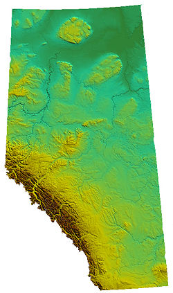
Terrain

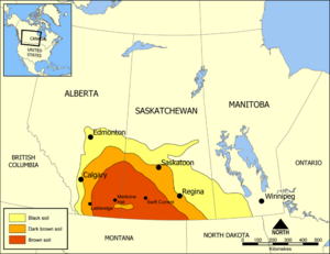
Alberta is a fertile province, as the eastern and southern portions of its surface consist chiefly of plains that are almost entirely treeless. As the slopes of the Rocky Mountains to the west are reached, more trees are found until in the foothills of the mountains, bodies of forest timber occur. Trees also become more numerous in the northern part of the province, until in the region north of the North Saskatchewan River forests are met with again. From the southern boundary line for 2.5° north the prairie is dry, but of good soil, which grows excellent crops when irrigated. North of this region, the surface of the province is of the most fertile soil, with ordinary rainfall sufficing for agriculture. Alberta also has large oil reserves, especially in the Athabasca Tar Sands in the north of the province.
The appearance of the prairie section of the province is that of undulating meadows, with rounded sloping ridges covered with shorter grasses, which serve for the support of large herds of beef cattle. The wooded portions of the terrain are dotted with clumps and belts of trees of moderate size, giving them a park-like appearance. In winter it is continuously very cold, but this is occasionally reduced by a warm wind from the west, known as the Chinook.
Mountains
Within a hundred kilometres of the mountains there is constantly in view, in clear weather, a line of snowy peaks along the western horizon. This continues for hundreds of kilometres northwestward. The Canadian Rockies are ascended by a gradual approach from the east, but are exceedingly abrupt on their transalpine slope in British Columbia. The peaks of these mountains are majestic, many of them reaching a height of more than three km above the sea. Among the more notable of these are:
- Mount Columbia - 3,747m (12,294 ft)
- Twin Peaks massif - 3,684 m (12,087 ft)
- Mount Alberta - 3,619m (11,874 ft)
- Mount Forbes - 3,612 m (11,851 ft)
- Mount Temple - 3,543m (11,624 ft)
- Mount Brazeau - 3,525 m (11,562 ft)
- Snow Dome - 3,520 m (11,546 ft)
- Mount Lyell - 3,504 m (11,493 ft)
- Mount Kitchener - 3,505 m (11,500 ft)
- Mount Hungabee - 3,492 m (11,457 ft)
Historically travel through these mountains was difficult, and alpine passes became very important. The most noted of the Alberta passes are:
- The Crowsnest Pass, near the southern boundary line, through which a branch of the Canadian Pacific Railway runs.
- The Kicking Horse Pass, through which the main line of the Canadian Pacific Railway was built; 80 miles (130 km) from the eastern end of this pass is the gate of Banff National Park, with the famous touristic town of Banff as its centre.
- The Yellowhead Pass, running west from the Athabasca River; this pass was discovered by John Palliser (1858), was crossed by Lord Milton and Dr W. B. Cheadle (1861), and by Sandford Fleming (1871-1872) in the Ocean to Ocean expedition;
The Caribou Mountains are not part of the Canadian Rockies, but are located in the northern Alberta, constituting an elevated plateau in the northern plains. They reach an altitude of 1,030 m, almost 700 m higher than the surrounding area.
While not considered mountains, the Cypress Hills, located in southern Alberta, on the Saskatchewan border, constitutes the highest point between the Rocky Mountains and Labrador. They reach a maximum elevation of 1,468 m, 600 m above the surrounding prairie.
Water

With the exception of the southern section, the province of Alberta may be said to be well watered. Rising from numerous valleys on the Alberta declivity of the Rocky Mountains between the international boundary line and 52° north are streams which unite to form the Oldman River, and farther north the Bow River. Running eastward these two rivers unite about 112° west, and flow on under the name of the South Saskatchewan River. North of 52° north many small streams unite to form the Red Deer River, which flowing southeastward joins the South Saskatchewan near 110° west. Between 52° and 53° north rises the great river, the North Saskatchewan. It receives a southern tributary, the Battle River, which joins it about 108° west. Pursuing their courses eastward the North and South Saskatchewan rivers unite in the Saskatchewan River (Cree, rapid-flowing river), which finds its way to Lake Winnipeg, and thence by way of Nelson River to Hudson Bay. It is one of the mightiest rivers of the continent.
At Mount Athabasca, there is an unusual occurrence where the water flows either to the Pacific ocean on the western slope, the Arctic ocean on the northeast, and the Atlantic Ocean on the southeast.
In the northern part of the province, between 53° and 54° north, all the waters of Alberta flow toward the Arctic Ocean. Starting at Mount Athabasca, the Athabasca River runs north and empties into Lake Athabasca near 58° north. North of 56° north flows through and from the Rocky Mountains as the Peace River. After descending northeastward to within a few miles of Lake Athabasca, it is met by a stream emerging from that lake. The united river carrying down the waters of the Athabasca slope is called the Slave River, which, passing through Great Slave Lake, emerges as the great Mackenzie River, which falls into the Arctic Ocean. Alberta thus gives rise to the two great rivers, the Saskatchewan and the Mackenzie.
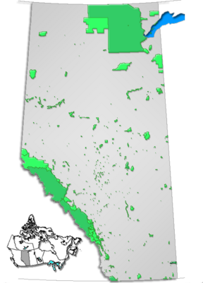
While a number of fresh-water, or in some cases brackish, lakes each less than 260 km² (100 mi²) in extent are situated in Alberta, two of more considerable size are found. These are Lake Athabasca, 7898 km² (3085 mi²) in extent, of which a part is in the province of Saskatchewan, and the other Lesser Slave Lake 1,160 km² (600 mi²) in area.
- See also: Lakes of Alberta
- See also: List of Alberta rivers
Climate
As Alberta extends for 1200 km (750 miles) from north to south, it is natural that the climate should vary considerably between parallels of 49° and 60° north and also between 110° and 120° west. It is also further influenced by the different altitudes above the sea of the several parts of the province. Dividing the province into three equal parts of 400 km. each from north to south, these may be called (A) the south, (B) the centre, (C) the north. The following data may be considered:
| Climate | Places | Above the Sea | Mean Winter Temp |
|---|---|---|---|
| (A) Moderate and changeable | Medicine Hat, lat. 50° N. | 2171 ft. 651 m | 14.3°F -9.8°C |
| Calgary, lat. 51° | 3432 ft. 1049 m | 15.4°F -9.2°C | |
| Banff, lat. 51.5° | 4515 ft. 1355 m | 15.9°F -8.9°C. | |
| (B) Steady | Edmonton, lat. 53.5° | 2210 ft. 663m | 10.3°F -12.1°C |
| (C) Severe | Fort Chipewyan, lat. 59° N. | 600 ft. 180 m | 7.2°F -13.8°C |
Climate (A) is a semi-arid, highland continental climate (Koppen climate classification BSk) that allows, in what is a great ranching district, cattle to run at large through the whole winter. Through the mountain passes come at times dry winds from the Pacific coast, which lick up the snow in a few hours. These winds are known as Chinook winds. While elevating the temperature they reduce the amount of moisture in the air and produce a change not entirely desirable.
Climate (B) is a more severe continental climate (Koppen Dfb), that being the steady winter climate and somewhat more humid climate of Edmonton district. This while averaging a lower temperature than (A) is not so subject to change; it retains the snow for sleighing, which is a boon to the farmer. This climate is much less influenced by the Pacific winds than (A) and is more typical of the eastern Prairies.
Climate (C), that of Fort Chipewyan, having a mean winter temperature of 4.6°C lower than Calgary, is a decidedly subarctic climate (Koppen Dfc). It is the region in winter of constant ice and snow, but its lower altitude gives it a summer climate with a mean temperature of only 0.9°C less than Calgary, and 1.0°C less than Edmonton.
See also
|
|||||||||||
|
||||||||||||||||||||||
|
|||||||||||||||||||
|
|||||||||||||||||||
|
||||||||||||||