Gelderland
| Provincie Gelderland Province of Gelderland |
|||||
|
|||||
 |
|||||
| Capital | Arnhem | ||||
| Largest city | Nijmegen | ||||
| Queen's Commissioner | Clemens Cornielje | ||||
| Religion (1999) | Protestant 31% Catholic 29% |
||||
| Area • Land • Water |
4,975 km² (1st) 161 km² |
||||
| Population (2006) • Total • Density |
1,975,704 (4th) 397/km² (6th) |
||||
| Anthem | Ons Gelderland | ||||
| ISO | NL-GE | ||||
| Official website | www.gelderland.nl | ||||
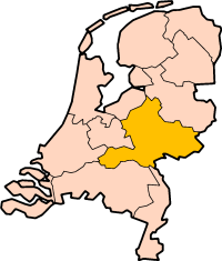
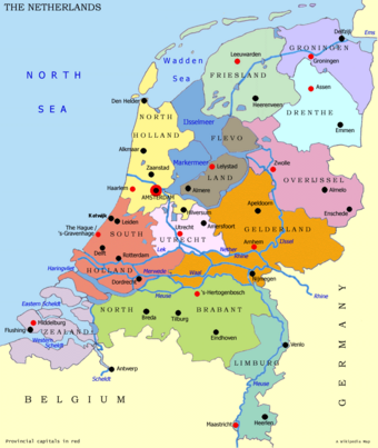
Gelderland (, English also Guelders) is a province of the Netherlands, located in the central eastern part of the country. The capital city is Arnhem. The two other major cities, Nijmegen and Apeldoorn have more inhabitants. Other major regional centers in Gelderland are Wageningen, Ede, Zutphen, Doetinchem, Harderwijk, Epe, Wijchen and Tiel.
Contents |
History
The current province of Gelderland covers about the area of three of the quarters of the historical Duchy of Guelders. Guelders was a county in the late 11th century and then a duchy in the Holy Roman Empire, including also parts of the province of present-day Limburg and the German District of Kleve (Cleves) with the city of Geldern, the city that was the original seat of the dukes. It became part of the Habsburg Netherlands in 1543, one of the Seventeen Provinces, though not one of the richer or more densely-populated.
Geography
Gelderland can be divided in three parts: the Veluwe in the north, the Betuwe in the southwest and the Achterhoek or Graafschap (which literally means: County or Earldom) in the east.
Municipalities
Currently (2006), the municipalities in Gelderland are as follows:
|
See also Betuwe, Linge.
Municipalities abolished on 1 Jan 2005
The following municipalities were abolished on 1 January 2005; see further [1](in Dutch) for more detailed information on these changes.
These municipalities were merged with neighbouring ones:
- Angerlo was merged into Zevenaar
- Dinxperlo was merged into Aalten
- Gorssel was merged into Lochem
- Lichtenvoorde was merged into Groenlo (later: Oost Gelre, see below)
- Warnsveld was merged into Zutphen
- Wehl was merged into Doetinchem
These municipalities were merged and given a new name:
- Borculo, Eibergen, Neede, and Ruurlo became Berkelland
- Hengelo, Hummelo en Keppel, Steenderen, Vorden, and Zelhem became Bronckhorst
- Bergh and Didam became Montferland
- Gendringen and Wisch became Oude IJsselstreek
- Lichtenvoorde, Groenlo, Lievelde, Zieuwent and smaller neighbouring villages became Oost Gelre
External links
|
|||||||