Garrett County, Maryland
| Garrett County, Maryland | |
| Map | |
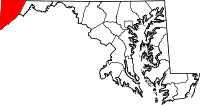 Location in the state of Maryland |
|
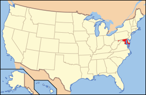 Maryland's location in the U.S. |
|
| Statistics | |
| Founded | 1872 |
|---|---|
| Seat | Oakland |
| Area - Total - Land - Water |
656 sq mi (1,699 km²) 648 sq mi (1,678 km²) 8 sq mi (21 km²), 1.21% |
| Population - (2000) - Density |
29,846 47/sq mi (18/km²) |
| Website: www.co.garrett.md.us | |
Garrett County is the westernmost county of the U.S. state of Maryland and is part of the Pittsburgh DMA. As of 2000, the population was 29,846. It was named for John Work Garrett (1820–1884), president of the Baltimore and Ohio Railroad from 1858 until his death in 1884. Its county seat is Oakland.
Contents |
History
The western part of Maryland (including the present Garrett County) was incorporated into Prince George's County in 1696. This county included six current counties, and by repeated splitting, new ones were generated: Frederick from Prince George's in 1748; Montgomery and Washington from Frederick in 1776; and Allegany from Washington in 1789.
Finally, Garrett County was split off from Allegany County in 1872, making it the last county to be formed in the state. The county was named for John Work Garrett, then president of the Baltimore and Ohio Railroad.
Law and government
The executive branch of government of Garrett County is governed by a board of county commissioners, the traditional form of county government in Maryland. The county is policed by the Garrett County Sheriff's Office and the Maryland State Police. The state parks are police by the Department of Natural Resources Police.
Cities and towns
Garrett County includes eight municipalities, all classified as towns under Maryland law:
- Accident (incorporated 1916)
- Deer Park (incorporated 1884)
- Friendsville (incorporated 1902)
- Grantsville (incorporated 1864)
- Kitzmiller (incorporated 1906)
- Loch Lynn Heights (incorporated 1896)
- Mountain Lake Park (incorporated 1931)
- Oakland (incorporated 1862)
The United States Census Bureau recognizes no Census-Designated Places (CDPs) in Garrett County, which is unusual for Maryland counties, which usually have many unincorporated population centers.
There are some areas in Garrett County that are not listed as CDPs. They are:
- Bittinger
- Bloomington
- Crellin
- Gorman
- Hutton
- McHenry
- Jennings
- Sang Run
- Shalmar
- Swanton
Geography
Garrett County lies in the Allegheny Mountains, which forms the western portion of the Appalachian Mountains. The western part of the county, drained by the Youghiogheny River, is the only part of Maryland within the Mississippi River watershed.
According to the U.S. Census Bureau, the county has a total area of 1,699 km² (656 sq mi). 1,678 km² (648 sq mi) of it is land and 21 km² (8 sq mi) of it (1.21%) is water.
Garrett County is part of the Pittsburgh DMA, a regional media market centered in neighboring Pennsylvania.
Major Highways
 Interstate 68
 U.S. Route 40
US 40 Alt U.S. Route 50
 U.S. Route 219
 Maryland Route 38
 Maryland Route 39
 Maryland Route 42
 Maryland Route 135
 Maryland Route 495
 Maryland Route 546
 Maryland Route 560
 Maryland Route 669
 Maryland Route 946
Adjacent counties
- Somerset County, Pennsylvania (north)
- Allegany County, Maryland, and Mineral County, West Virginia (east)
- Grant County, West Virginia (southeast)
- Tucker County, West Virginia (south)
- Preston County, West Virginia (west)
- Fayette County, Pennsylvania (northwest)
Demographics
As of the census[1] of 2000, there were 29,846 people, 11,476 households, and 8,354 families residing in the county. The population density was 18/km² (46/sq mi). There were 16,761 housing units at an average density of 10/km² (26/sq mi). The racial makeup of the county was 98.83% White, 0.43% Black or African American, 0.07% Native American, 0.19% Asian, 0.02% Pacific Islander, 0.09% from other races, and 0.37% from two or more races. 0.44% of the population were Hispanic or Latino of any race. 36.1% were of German, 22.9% American, 9.6% English and 8.8% Irish ancestry according to Census 2000.
There were 11,476 households out of which 32.60% had children under the age of 18 living with them, 60.70% were married couples living together, 8.40% had a female householder with no husband present, and 27.20% were non-families. 23.50% of all households were made up of individuals and 10.60% had someone living alone who was 65 years of age or older. The average household size was 2.55 and the average family size was 3.00.
In the county the population was spread out with 25.10% under the age of 18, 7.80% from 18 to 24, 27.60% from 25 to 44, 24.60% from 45 to 64, and 14.90% who were 65 years of age or older. The median age was 38 years. For every 100 females there were 97.20 males. For every 100 females age 18 and over, there were 93.80 males.
The median income for a household in the county was $32,238, and the median income for a family was $37,811. Males had a median income of $29,469 versus $20,673 for females. The per capita income for the county was $16,219. 13.30% of the population and 9.80% of families were below the poverty line. Out of the total people living in poverty, 16.60% are under the age of 18 and 13.90% are 65 or older.
See also
- USS Garrett County (LST-786)
- Meshach Browning
Notes
- ↑ "American FactFinder". United States Census Bureau. Retrieved on 2008-01-31.
References
- Albert L. Feldstein, "Garrett County (Postcard History)", Arcadia Publishing, 2006, ISBN 0-7385-4266-0 (Featured are Garrett’s numerous towns and communities; downtown business scenes; residential views; historic buildings, churches, railroad stations; and the great resort hotels. Also included are the county’s many historic and natural landmarks, rustic scenes, the Deep Creek Lake area, and varied sites along the historic National Road. A special element is the inclusion of many of the personal messages sent on the back of the postcards.)
External links
|
||||||||||||||
|