Galveston, Texas
- "Galveston" redirects here. For other uses, see Galveston (disambiguation).
| City of Galveston | |||
 |
|||
|
|||
| Nickname(s): The Oleander City | |||
 |
|||
| Coordinates: | |||
| Country | United States of America | ||
|---|---|---|---|
| State | Texas | ||
| Counties | Galveston | ||
| Incorporated | 1839 | ||
| Government | |||
| - Type | Council-manager | ||
| - Mayor | Lyda Ann Thomas | ||
| Area | |||
| - Total | 208.3 sq mi (539.6 km²) | ||
| - Land | 46.1 sq mi (119.5 km²) | ||
| - Water | 162.2 sq mi (420.1 km²) | ||
| Elevation | 7 ft (2 m) | ||
| Population (2005) | |||
| - Total | 57,466 | ||
| - Density | 1,240.3/sq mi (478.9/km²) | ||
| - Demonym | Galvestonian | ||
| Time zone | CST (UTC-6) | ||
| - Summer (DST) | CDT (UTC-5) | ||
| ZIP codes | 77550-77555 | ||
| Area code(s) | 409 | ||
| FIPS code | 48-28068[1] | ||
| GNIS feature ID | 1377745[2] | ||
| Website: www.cityofgalveston.org | |||
Galveston (pronounced /ˈgælvəstən/) is a city in and seat of Galveston County located on Galveston Island on the Gulf Coast in the U.S. state of Texas within the Houston–Sugar Land–Baytown metropolitan area. As of the 2005 U.S. Census estimate, the city had a total population of 57,466. Galveston is accessible by the Galveston Causeway linking Galveston Island to the mainland on the north end of the city, a toll bridge on the western end of the island, and by ferry boat service on the east end of the city.
Galveston is known for the hurricane that struck it in 1900. The natural disaster that followed still counts as the most deadly in American history. A 10-mile (16-km) long, 17-foot (5.18 m) high seawall protects the city from floods and hurricane storm surge.
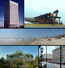
The city's tourist attractions include the Galveston Schlitterbahn waterpark, Moody Gardens botanical park, the Ocean Star Offshore Drilling Rig & Museum, the Lone Star Flight Museum, a downtown neighborhood of historic buildings known as The Strand, many historical museums and mansions, and miles of beach front. The Strand plays host to a yearly Mardi Gras festival, Galveston Island Jazz & Blues Festival, Texas Beach Fest, Lone Star Bike Rally, and a Victorian-themed Christmas festival called Dickens on the Strand (honoring the works of novelist Charles Dickens, especially A Christmas Carol) in early December. Galveston was also home to the Balinese Room, an historic nightclub, formerly a notorious illegal gambling hall, which was located on a 600-foot (200 m) pier extending into the Gulf of Mexico.[3]
Galveston is the second-largest city in Galveston County in population after League City; League City surpassed Galveston between 2000 and 2005.[4]
Hurricane Ike made landfall at Galveston, Texas, on September 13, 2008. After it extensively damaged the courthouse and jail in September 2008, the decision was made to temporarily relocate the county seat and offices to League City and Texas City. Once repairs are complete, the county headquarters will return to Galveston.[5]
Contents |
History
Exploration and settlement
Galveston island was originally inhabited by members of the Karankawa and Akokisa tribes, who used the name "Auia" for the island. The Spanish explorer Cabeza de Vaca and his crew were shipwrecked on the island (or nearby) in November 1528,[6] calling it "Isla de Malhado" ("Isle of Doom"),[7] and there began his famous trek to Mexico.
During his charting of the Gulf Coast in 1785, the Spanish explorer José de Evia named the island Gálvez-town or Gálveztown in honor of Bernardo de Gálvez y Madrid, Count of Gálvez.[7][8] The first permanent European settlements on the island were constructed around 1816 by the pirate Louis-Michel Aury as a base of operations to support Mexico's rebellion against Spain. In 1817 Aury returned from an unsuccessful raid against Spain to find Galveston occupied by the pirate Jean Lafitte, who took up residence there after having been driven from his stronghold in Barataria Bay off the coast of New Orleans, Louisiana. Lafitte organized Galveston into a pirate "kingdom" he called "Campeachy" (or "Campeche"), anointing himself the island's "head of government." Lafitte remained in Galveston until 1821 when he and his raiders were given an ultimatum by the United States Navy: leave or be destroyed. Lafitte burned his settlement to the ground and sailed under cover of night for parts unknown. There are still rumors that Lafitte's treasure is buried somewhere between Galveston Island, Bolivar Peninsula and High Island.
Following its successful revolution from Spain, the Congress of Mexico issued a proclamation on October 17, 1825, establishing the Port of Galveston, and in 1830 erected a customs house. During the Texas Revolution, Galveston served as the main port for the Texas navy. Galveston also served as the capital of the Republic of Texas when in 1836 interim president David G. Burnet relocated his government there.
In 1836, Michel B. Menard, a native of Canada, along with several associates purchased 4,605 acres (18.64 km²) of land for $50,000 from the Austin Colony to found the town that would become the modern city of Galveston. Menard and his associates began selling plots on April 20, 1838. In 1839, the City of Galveston adopted a charter and was incorporated by the Congress of the Republic of Texas.
The Battle of Galveston was fought in Galveston Bay and on the island on January 1, 1863, during the American Civil War when Confederate forces under Major General John B. Magruder attacked and expelled occupying Union troops from the city, which remained in Confederate hands for the duration of the war. In May 1865, the Lark successfully evaded the Union blockade off of Galveston Harbor and headed for Havana, becoming the final Confederate ship to slip through the blockade from any Southern port.[9]
Juneteenth, which is the oldest nationally celebrated commemoration of the ending of slavery in the United States, owes its origins to the announcement of the Emancipation Proclamation upon the return of Union forces to Galveston in 1865.
In the late 1890s, the Fort Crockett defenses and coastal artillery batteries were constructed in Galveston and along the Bolivar Roads. [10]
Growth


At the end of the 19th century, the city of Galveston was a booming metropolis with a population of 37,000. Its position on the natural harbor of Galveston Bay along the Gulf of Mexico made it the center of trade in Texas, and one of the largest cotton ports in the nation, in competition with New Orleans. Between 1838 and 1842, 18 newspapers were started to serve the island's rapidly growing population (The Galveston County Daily News is the sole survivor). A causeway linking the island with the mainland was finished in 1860, which paved the way for railroad expansion.
During this era, Galveston was also home to a number of state firsts, including: the first post office (1836), the first naval base (1836), the first Texas chapter of a Masonic order (1840); the first cotton compress (1842), first Roman Catholic Cathedral (St. Mary's Cathedral Basilica) (1847), the first parochial school (Ursuline Academy) (1847), the first insurance company (1854), the first gas lights (1856), first Jewish Reform Congregation (Congregation B'nai Israel) (1868), the first opera house (1870), the first orphanage (1876), the first telephone (1878), the first electric lights (1883), the first medical college (now the University of Texas Medical Branch) (1891), and the first school for nurses (1890).
Storm of 1900

In 1900, the island was struck by a devastating hurricane. Even post-Hurricane Katrina, this event holds the record as the United States' deadliest natural disaster.
In the early morning of September 8, high surf despite prevailing winds out of the north heralded the oncoming storm. By noon low-lying areas near the Gulf and the Bay side of the city were taking on water and the winds increased. Near 4 p.m. a storm surge approximately 15 feet (5 m) high slammed into the coast. According to many personal accounts, the storm subsided before midnight. Wind speeds reached up to 125 mph (an estimate, since the anemometer was blown off the U.S. Weather Bureau building). Isaac Cline was the bureau's chief meteorologist. An account of the events surrounding the hurricane based on his personal records is given in Isaac's Storm by Erik Larson. The city was devastated, and an estimated 6,000 to 8,000 people on the island were killed.
After the storm cleared, the city decided to shore up its defenses against future storms: a permanent concrete seawall was built along a large portion of the beach front (1902–1904) and the entire grade of the city was raised some 17 feet (5 m) behind the wall to a few feet near the Bay (1904–1910). Just after the hurricane, the city originated the City Commission form of city government (which became known as the "Galveston Plan"), although the city has since adopted the Council-Manager form of government.

Despite attempts to draw new investment to the city after the hurricane, Galveston never fully returned to its previous levels of national importance or prosperity. Development was also hindered by the construction of the Houston Ship Channel, which brought the Port of Houston into direct competition with the natural harbor of Galveston Bay for sea traffic. To further her recovery, and rebuild her population, Galveston actively solicited immigration. Through the efforts of Rabbi Henry Cohen and Congregation B'nai Israel, Galveston became the focus of a 1907 immigration plan called the Galveston Movement that, in the following years, diverted roughly 10,000 Eastern European, Jewish immigrants from the crowded cities of the Northeastern United States.
Post-1900s

Though the storm stalled economic development and the city of Houston grew into the region's principal metropolis, Galveston has regained some of its former glory. Today it is considered a major tourist destination, and remains a port of entry and a destination for cruise ships, and a port of call and repairs for cargo ships. Galveston is currently ranked the number 1 cruise port on the Gulf Coast and number 4 in North America (2007). The city features an array of lodging options, including fine hotels, vintage bed & breakfast inns, beachfront condominiums, and resort rentals.
Galveston's historic downtown and abundant beaches are major tourist destinations. Houstonians and visitors from around the world purchase beach homes and condominiums and make Galveston their second home.
Other attractions in Galveston include Moody Gardens, the Ocean Star Offshore Drilling Rig & Museum, the Galveston Railroad Museum, Schlitterbahn, the Strand and the Lone Star Flight Museum. Galveston is also home to several historic ships: the tall ship Elissa (the official Tall Ship of Texas) at the Texas Seaport Museum and USS Cavalla and USS Stewart, both berthed at Seawolf Park on nearby Pelican Island. Galveston is also home to a symphony orchestra and a small ballet company.
The Galveston County Daily News, the city's main newspaper, is the oldest continuously printed newspaper in Texas since 1842.[11] Galveston.com, the city's official tourism website, launched in the fall of 1994. [12]
Galveston has been the home of the University of Texas Medical Branch (UTMB) since 1891. UTMB is a major teaching and indigent-care hospital which now encompasses 84 acres (340,000 m²)., UTMB is the largest employer in Galveston County[13], creating over 15,000 jobs and bringing about $300 million into the local economy. The Shriners Hospital adjacent to UTMB is a 30-bed pediatric burn hospital providing comprehensive acute care and reconstructive and rehabilitative care to children who have been burned. American National Insurance Company, one of the largest life insurance companies in the United States, and Moody National Bank are headquartered in Galveston.


Galveston's beaches are much cleaner than in the past. With the island's population showing greater concern for their environment, washed-up seaweed is now only moved back from the water's edge to allow the natural buildup and preservation of the beaches. The beaches are now cleaned daily by the Galveston Park Board.
In the 2000s, property values rose after expensive projects were completed [14] and demand for second homes increased.[15] This led some middle class families to move from Galveston to other areas such as League City, Texas City, and La Marque. The city population remained relatively the same from 2000 to 2005 according to the U.S. Census Bureau.[4]
In 2007 The Associated Press compiled a list of the most vulnerable places to hurricanes in the U.S. and Galveston was one of five areas named. Among the reasons cited were low elevation and the single evacuation route off the island which is blocked by the fourth largest city in the United States, Houston.[16]
Hurricane Ike
Hurricane Ike made landfall on Galveston Island in the early morning of September 13, 2008 as a category 2 hurricane with winds of 110 mph.[17] Homeland Security secretary Michael Chertoff said the previous day that the hurricane might cause "catastrophic effects" and "threaten the lives and safety of citizens along the Texas coast and the western part of Louisiana".[18] Ike produced waves and a rising storm surge which overcame the famous Galveston Seawall.[19][20] While most residents evacuated the island prior to the storm, many decided to stay.[21][20] One person explained, "I've decided not to evacuate. We have a lot of faith in the seawall, and we have boards on the windows. Most people on the island live on second or third stories, so they don't have to worry about the water so much."[22] The flooding caused by the storm surge caused many to change their minds, and an attempt was made by the Coast Guard and local officials to rescue hundreds of persons trapped on the island.[22]
The storm left Galveston without electricity, gas, water pressure and basic communications.[23]
Public housing projects in Galveston were one of the hardest hit areas. The Galveston Housing Authority hopes to move away from traditional housing developments and adopt a program of building houses for individual low-income families. [24] Galveston ISD too suffered enormous damage from Hurricane Ike; the school district lost over 2,300 students, when compared to 07-08 enrollment numbers. [25]
Architecture
Buildings in Galveston notable for their architecture include many in the historic Strand District, The Hotel Galvez, the Moody Mansion, Ashton Villa, and the Bishop's Palace (also known as 'Gresham's Castle'). The restored Grand 1894 Opera House is still in use.
Tallest buildings:
- Palisade Palms Trade Winds Tower (Under construction)
- Palisade Palms Beach Club (Under construction)
- The Emerald Condominiums (Under construction)
- Ocean Grove Condominiums (Under construction)
- East Beach Resort & Spa (Under construction)
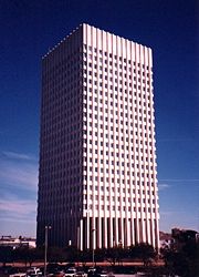
- American National Insurance Company Tower (One Moody Plaza)
- San Luis Resort South Tower
- San Luis Resort North Tower
- The Breakers Condominiums
- The Galvestonian Resort and Condos
- One Shearn Moody Plaza
- US National Bank Building
- By The Sea Condominiums
- John Sealy Hospital Towers at UTMB
- Medical Arts Building (aka Two Moody Plaza)
Economy
The Port of Galveston, also called Galveston Wharves, began as a trading post in 1825. Today, the port has grown to 850 acres (3.4 km2) of port facilities. The port is located on the Gulf Intracoastal Waterway, on the north side of Galveston Island, with some facilities on Pelican Island. The port has facilities to handle all types of cargo including containers, dry and liquid bulk, breakbulk, RO/RO, refrigerated, and project cargoes. The port of Galveston also serves as a passenger cruise ship terminal for cruise ships operating in the Caribbean. It homports 2 Carnival Cruise Lines vessels the Carnival Conquest and the Carnival Ectasy. It also homeports Royal Caribbean International Voyager of the seas.
Geography and climate
Galveston is located at (29.281137, -94.825945)[26].
According to the United States Census Bureau, the city has a total area of 208.4 square miles (540 km2), of which, 46.2 square miles (120 km2) of it is land and 162.2 square miles (420 km2) of it (77.85%) is water.
| Month | Jan | Feb | Mar | Apr | May | Jun | Jul | Aug | Sep | Oct | Nov | Dec | Year |
|---|---|---|---|---|---|---|---|---|---|---|---|---|---|
| Record high °F (°C) | 78 (26) |
83 (28) |
87 (31) |
92 (33) |
94 (34) |
99 (37) |
101 (38) |
100 (38) |
104 (40) |
94 (34) |
85 (29) |
80 (27) |
104 (40) |
| Average high °F (°C) | 61.9 (17) |
64.4 (18) |
70.0 (21) |
75.2 (24) |
81.4 (27) |
86.6 (30) |
88.7 (32) |
89.3 (32) |
86.5 (30) |
79.7 (27) |
71.3 (22) |
64.3 (18) |
76.6 (25) |
| Average low °F (°C) | 49.7 (10) |
51.5 (11) |
58.2 (15) |
64.7 (18) |
72.3 (22) |
77.8 (25) |
79.8 (27) |
79.5 (26) |
75.6 (24) |
68.4 (20) |
59.4 (15) |
51.8 (11) |
65.7 (19) |
| Record low °F (°C) | 11 (-12) |
8 (-13) |
26 (-3) |
38 (3) |
52 (11) |
57 (14) |
66 (19) |
67 (19) |
52 (11) |
39 (4) |
26 (-3) |
14 (-10) |
8 (-13) |
| Precipitation inches (mm) | 4.08 (103.6) |
2.61 (66.3) |
2.76 (70.1) |
2.56 (65) |
3.70 (94) |
4.04 (102.6) |
3.45 (87.6) |
4.22 (107.2) |
5.76 (146.3) |
3.49 (88.6) |
3.64 (92.5) |
3.53 (89.7) |
43.84 (1,113.5) |
| Source: National Weather Service[27] June 2008 | |||||||||||||
Cityscape
A 2003 report written by D. Freeman of the University of Texas Medical Branch identified several communities within Galveston. The western portion of Galveston is referred to as the "West End." Communities in eastern Galveston include Lake Madeline, Offats Bayou, Central City, Fort Crockett, Bayou Shore, Lasker Park, Carver Park, Kempner Park, Old City/Central Business District, San Jacinto, East End, and Lindale.[28] Residential communities in the West End include Laguna Harbor.[29]
Demographics
As of the census[1] of 2000, there were 57,247 people, 23,842 households, and 13,732 families residing in the city. The population density was 1,240.4 people per square mile (478.9/km²). There were 30,017 housing units at an average density of 650.4/sq mi (251.1/km²). The racial makeup of the city was 58.66% White, 25.49% Black or African American, 0.42% Native American, 3.21% Asian, 0.07% Pacific Islander, 9.73% from other races, and 2.41% from two or more races. 25.77% of the population were Hispanic or Latino of any race.
There were 23,842 households out of which 26.3% had children under the age of 18 living with them, 36.6% were married couples living together, 16.9% had a female householder with no husband present, and 42.4% were non-families. 35.6% of all households were made up of individuals and 11.2% had someone living alone who was 65 years of age or older. The average household size was 2.30 and the average family size was 3.03.
In the city the population was spread out with 23.4% under the age of 18, 11.3% from 18 to 24, 29.8% from 25 to 44, 21.8% from 45 to 64, and 13.7% who were 65 years of age or older. The median age was 36 years. For every 100 females there were 93.4 males. For every 100 females age 18 and over, there were 90.4 males.
The median income for a household in the city was $28,895, and the median income for a family was $35,049. Males had a median income of $30,150 versus $26,030 for females. The per capita income for the city was $18,275. About 17.8% of families and 22.3% of the population were below the poverty line, including 32.1% of those under age 18 and 14.2% of those age 65 or over.
Government and infrastructure
Local government
The city's charter specifies a council-manager government. Galveston's city council serves as the city's legislative branch, while the City Manager works as the chief executive officer and the municipal court system serves as the city's judicial branch. The city council and mayor promote ordinances to establish municipal policies. The Galveston City Council consists of six elected positions, each derived from a specified voting district. Each city council member is elected to a two year term, while the mayor is elected to a two year term. The city council appoints the City Manager, the City Secretary, the City Auditor, the City Attorney, and the Municipal Judge. The city's Tax Collector is, as of 2008 and as determined by the city council, outsourced to Galveston County. The city manager hires employees, promotes development, presents and administers the budget, and implements City Council policies. As of 2008 Lyda Ann Thomas is the mayor and the City Council members are Tarris L. Woods (District 1), Linda Colbert (District 2), Elizabeth Beeton (District 3), Susan Fennewald (District 4), Danny L. Weber (District 5), and Karen Mahoney (District 6).[30] Galveston's city hall is located at 823 Rosenberg Avenue.[31]
The Galveston Fire Department provides fire protection services through six fire stations and seventeen pieces of apparatus; the fire department administration and the fire marshal are, respectively, in Suite 202 and Suite 203 at 2517 Ball Street.[32] The Galveston Police Department provides the city's police service; it is headquartered at 601 54th Street.[33]
County, state, and federal representation

The Galveston County Justice Center, the headquarters of the county, is located at 600 59th Street in Galveston.[34] Galveston is within the County Precinct 1; as of 2008 Patrick Doyle serves as the Commissioner of Precinct 1.[35] The Galveston County Sheriff's Office operates its law enforcement headquarters at 601 54th Street,[36] while the jail is located at 5700 Avenue H.[37] The Galveston County Department of Parks and Senior Services operates the Galveston Community Center at 2201 Avenue L.[38]
Galveston is located in District 23 of the Texas House of Representatives. As of 2008, Craig Eiland represents the district.[39] Most of Galveston is within District 17 of the Texas Senate; as of 2008 Kyle Janek represents the district.[40] A portion of Galveston is within District 11 of the Texas Senate; as of 2008 Mike Jackson represents the district.[41]
Galveston is in Texas's 14th congressional district. As of 2008, Ron Paul represents the district.[42]
The United States Postal Service operates post offices in Galveston, including the Galveston Main Post Office at 601 25th Street,[43] and the Bob Lyons Post Office Station at 5826 Broadway Street,[44]
In addition the post office has a contral postal unit at the Medical Branch Unit on the campus of the University of Texas Medical Branch. In November 2007 West Galveston Contract Unit, a Contract Postal Unit, opened inside a local business at Bob Smith Drive near Farm to Market Road 3005 in Jamaica Beach, a city sandwiched in between sections of Galveston.[45]
Transportation
Airports

Scholes International Airport at Galveston (IATA: GLS, ICAO: KGLS) is a two-runway airport in Galveston; the airport is primarily used for general aviation, offshore energy transportation, and some limited military operations. Commercial airline service is operated out of Houston through William P. Hobby Airport and George Bush Intercontinental Airport. University of Texas Medical Branch has two heliports: one for Ewing Hall and one for its emergency room.
Mass transit
Island Transit, which also runs the Galveston Island Trolley, operates Galveston Island's public transportation services.
Freeway system
Interstate 45 has a southern terminus in Galveston and serves as a main artery to Galveston from mainland Galveston County and Houston. Farm to Market Road 3005 (locally called Seawall Boulevard) connects Galveston to Brazoria County via the San Luis Pass-Vacek toll bridge. And State Highway 87, known locally as Broadway Street, connects the island to the Bolivar Peninsula via the free Bolivar Ferry.
Intercity buses
Greyhound Bus Lines serves Galveston Station, which is located at 3825 Broadway Street.[46]
In pop culture
The Jimmy Buffett song, "Who's the Blonde Stranger?" and Jimmy Webb's "Galveston" (popularized by Glen Campbell) are set in or refer to Galveston, as are ZZ Top's "Balinese", Greg Trooper used Galveston in a song called No Higher Ground (in reference to the 1900 Galveston Hurricane), Dierks Bentley's "I Can Only Think of One", Gene Autry's "Gallivantin' Galveston Gal" and R.E.M.:s "Houston".
The Galveston shoreline was the filming location for the infamous beach-driving scene between Jack Nicholson and Shirley MacLaine in the 1983 Oscar-winning film Terms of Endearment.
Rapper DMX shot the music video for "Party Up (In Here)" at the Frost Bank in Galveston. [47]
Education
Colleges and universities
The city is home to three post-secondary institutions: Galveston College (a junior college opened in 1967), Texas A&M University at Galveston, and University of Texas Medical Branch.
Primary and secondary schools
Public schools

The city of Galveston is served by Galveston Independent School District. Six district public elementary schools, including Burnet, L. A. Morgan, Greta Oppe, Gladneio Parker, Henry Rosenberg, and Charles B. Scott, serve grades pre-Kindergarten through 4. All Galveston Island residents are assigned to Weis Middle School for grades 5 through 6, Central Middle School for grades 7 through 8, and Ball High School for grades 9 through 12. One magnet middle school, Austin Middle School, has grades 5 through 8.
Prior to 1968, Galveston operated Ball High School for White students and Central High School for Black students; Central School, the first Texas public school for African-Americans, opened in 1885 and became a high school in 1886. In 1968 the two high schools consolidated and the Central campus became a junior high school.[48] Travis Elementary School, which opened in 1948, closed in the 1970s.[49][50] Crockett Elementary School closed by 1978.[51] The tax base of the Galveston ISD grew by 13% in 2005 while Galveston ISD lost many district-zoned non-Hurricane Katrina evacuee students.[4] San Jacinto Elementary School closed in 2006.[52] Alamo Elementary School, which opened in 1935 and received renovations in 1980 and 1986, closed in 2007.[52][53] Prior to fall 2008, Galveston ISD had a different school configuration: Elementary schools served pre-Kindergarten through grade 5 and Austin, Weis, and Central middle schools served grades 6 through 8.[54]
Galveston also has State charter schools, state-funded schools not affiliated with local school districts, including Kindergarten through 5th Grade Ambassadors Preparatory Academy[55] and Pre-Kindergarten through 8th Grade Odyssey Academy.[56]
Private schools

Several private schools exist in Galveston. The Roman Catholic Archdiocese of Galveston-Houston operates two Roman Catholic private schools, including Galveston Catholic School (K through 8th)[57] and O'Connell College Preparatory School (9-12). O'Connell Consolidated High School opened in 1968 as a consolidation of Kirwin, Dominican and Ursuline, three Galveston Catholic high schools.[58] Galveston Catholic School opened in 1986 as a consolidation of Dominican School, Our Lady of Guadalupe School, Saint Patrick's School, and O’Connell Junior High School.[59] Saint Patrick's opened in 1881 and received its final campus in 1926. Some parents protested plans to consolidate the schools before the consolidation became final.[60] O'Connell was renamed to O'Connell College Preparatory School in 2007.[58]
Satori Elementary School, a non-religious Kindergarten through Grade 6 school, is on the island.[61] Trinity Episcopal School, a PreK-8 Episcopal Church school, is on the island.[62] Two Kindergarten through 12th grade schools, Seaside Christian Academy (affiliated with Seaside Baptist Church in Jamaica Beach) and Heritage Christian Academy, are in Galveston.[63]
Public libraries

The city is served by the Rosenberg Library. [64] The library serves as headquarters of the Galveston County Library System, which opened in 1941. The Rosenberg Library's librarian also functions as the Galveston County Librarian.[65]
Sister cities
Galveston has seven sister cities, as designated by Sister Cities International:[66]
 Armavir, Armenia
 Thiruvananthapuram, India
 Veracruz, Mexico
 Stavanger, Norway
 Niigata, Japan
 Cape Town, South Africa
 Tamsui, Republic of China
See also
- Galveston Hurricane of 1900
- Hurricane Ike
- Isaac's Storm
Notes
- ↑ 1.0 1.1 "American FactFinder". United States Census Bureau. Retrieved on 2008-01-31.
- ↑ "US Board on Geographic Names". United States Geological Survey (2007-10-25). Retrieved on 2008-01-31.
- ↑ "History." Balinese Room. June 22, 2006.
- ↑ 4.0 4.1 4.2 Schladen, Marty. "Forces drive people off island." Galveston County Daily News. July 23, 2006.
- ↑ Rendon, Ruth. "Galveston County Commissioners move County Seat and Courts." Houston Chronicle. September 24, 2008.
- ↑ Donald E. Chipman (2008-01-18). "The Handbook of Texas Online" article "MALHADO ISLAND". www.tshaonline.org. Retrieved on 2008-09-30.
- ↑ 7.0 7.1 McComb, David G.: Galveston A History, University of Texas Press, 1986, 293 pp., ISBN 978-0-292-72053-4
- ↑ Bahia de Galvez-towm, de Evia, 1809-19, The Antiquarium Antique Print & Map Gallery, Houston, Texas, retrieved 14 Feb 2008
- ↑ Galveston Weekly News, April 26, 1865.
- ↑ "Galveston Laboratory Home". Galveston.ssp.nmfs.gov. Retrieved on 2008-10-28.
- ↑ "The Galveston County Daily News". Galvestondailynews.com. Retrieved on 2008-10-28.
- ↑ "GALVESTON.COM: About Galveston.com & Company". Galveston.com. Retrieved on 2008-10-28.
- ↑ "Find a County". National Association of Counties. Retrieved on 2008-01-31.
- ↑ Novak, Shonda. "Growth Wave Hits Galveston." Austin American-Statesman. Saturday July 22, 2006.
- ↑ http://www.chron.com/disp/story.mpl/headline/metro/4571804.html] ("Workers in Galveston increasingly can't afford to live there", Houston Chronicle, February 22, 2007)
- ↑ "Where’s the next New Orleans?." Associated Press. 2005.
- ↑ "Ike Insured Damage Estimates Range from $6B to $18B". Insurance Journal. September 15, 2008. Retrieved September 15, 2008. "Hurricane Ike made landfall at Galveston, Texas at 3:10 am EDT, Saturday, Sept. 13, as a strong Category 2 hurricane. Maximum sustained winds at landfall were 110 mph (180 km/h), just shy of Category 3 on the Saffir-Simpson intensity scale."
- ↑ United States Department of Homeland Security (2008-09-12). "Remarks by Homeland Security Secretary Michael Chertoff and Other Federal Officials at FEMA Headquarters on Hurricane Ike". Press release. Retrieved on 2008-15-08.
- ↑ Mike Carney, Oren Dorell (2008-09-12). "Hurricane Ike: Galveston says 25% ignored evacuation order". USA TODAY. Retrieved on 2008-09-12.
- ↑ 20.0 20.1 Ben Casselman (2008-09-12). "As Waters Rise, Many Decline To Leave Galveston Island". The Wall Street Journal. Retrieved on 2008-09-13.
- ↑ "Ike Blog: Minute-by-minute." WFAA-TV. Accessed September 13, 2008.
- ↑ 22.0 22.1 "One death as Ike edges toward Category 3 power." CNN. September 12, 2008. Retrieved September 15, 2008.
- ↑ ""Houston's post-Ike supplies coming, officials say." CNN. September 15, 2008. Retrieved September 15, 2008.
- ↑ "Galveston Housing Authority to emulate Biloxi." Galveston County Daily News. November 30, 2008. Retrieved November 30, 2008.
- ↑ ""Enrollment continues to grow as students return." Galveston Independent School District. October 16, 2008. Retrieved November 30, 2008.
- ↑ "US Gazetteer files: 2000 and 1990". United States Census Bureau (2005-05-03). Retrieved on 2008-01-31.
- ↑ "National Weather Service Forecast Office Houston/Galveston, Texas: Galveston Climate Data (see: "Normals, Means and Extremes")". Retrieved on June 30, 2008.
- ↑ "Map 1. Galveston’s Neighborhoods." Galveston County, Texas. December 12, 2003.
- ↑ "Directions." Laguna Harbor. Retrieved on November 7, 2008.
- ↑ "The City Council of Galveston, Texas." City of Galveston. Retrieved on November 7, 2008.
- ↑ "Governmental Offices." Galveston Chamber of Commerce. Retrieved on November 7, 2008.
- ↑ "Fire Department." City of Galveston. Retrieved on November 7, 2008.
- ↑ Home Page. Galveston Police Department. Retrieved on November 7, 2008.
- ↑ "Galveston County Justice Center." Galveston County, Texas. Accessed November 7, 2008.
- ↑ "Precinct 1." Galveston County, Texas. Retrieved on November 7, 2008.
- ↑ "Welcome to the Galveston County Sheriff's Office Home Page." Galveston County Sheriff's Office. Retrieved on November 7, 2008.
- ↑ "Galveston County Sheriff's Office Corrections Bureau - Jail Division." Galveston County Sheriff's Office. Retrieved on November 7, 2008.
- ↑ Facilities Overview." Galveston County Department of Parks and Senior Services. Retrieved on November 7, 2008.
- ↑ "District 23." Texas House of Representatives. Retrieved on November 7, 2008.
- ↑ "Senate District 17" Map. Senate of Texas. Retrieved on November 7, 2008.
- ↑ "Senate District 11" Map. Senate of Texas. Retrieved on November 7, 2008.
- ↑ "Congressional District 14." National Atlas of the United States.
- ↑ "Post Office™ Location - GALVESTON." United States Postal Service. Retrieved on December 6, 2008.
- ↑ "Post Office™ Location - BOB LYONS." United States Postal Service. Retrieved on December 6, 2008.
- ↑ The Galveston County Daily News
- ↑ "Galveston, Texas." Greyhound Lines. Accessed October 27, 2008.
- ↑ Music Video on YouTube (Take a look at fire trucks as they say Galveston Fire Department)
- ↑ Jones, Leigh. "Alumni recall Central High’s final year." Galveston County Daily News. August 11, 2008.
- ↑ Galveston Daily News. Tuesday March 9, 1976.
- ↑ Cherry, Bill. "1949: Central High's facilities were poor." Galveston County Daily News. November 29, 2004.
- ↑ Stanton, Carey. "After 42 years, school’s out for teacher." Galveston County Daily News. June 16, 2002.
- ↑ 52.0 52.1 Meyers, Rhiannon. "District swaps one empty school for another." Galveston County Daily News. May 9, 2008.
- ↑ Meyers, Rhiannon. "Some parents beg that Alamo be reopened." Galveston County Daily News. December 9, 2007.
- ↑ Meyers, Rhiannon. "Changes awaiting students this year." Galveston County Daily News. August 24, 2008.
- ↑ Home Page. Ambassador Preparatory Academy. Accessed October 27, 2008.
- ↑ Home Page. Odyssey Academy. Accessed October 27, 2008.
- ↑ Home Page. Galveston Catholic School. Accessed October 27, 2008.
- ↑ 58.0 58.1 Taylor, Heber. "O'Connell seeks to redefine itself." Galveston County Daily News. September 23, 2007.
- ↑ Meyers, Rhiannon. "Principal says it’s ‘best job I’ve ever had’." Galveston County Daily News. August 30, 2007.
- ↑ Moran, Kevin and Allan Turner. "Merging of schools protested." Houston Chronicle. March 16, 1986. Section 3, Page 8.
- ↑ Home Page. Satori School. Accessed October 27, 2008.
- ↑ Home Page." Trinity Episcopal School. Accessed October 27, 2008.
- ↑ "Welcome New VizaWeb Client". Seasideacademy.org. Retrieved on 2008-10-28.
- ↑ "Rosenberg Library". Rosenberg-library.org. Retrieved on 2008-10-28.
- ↑ "Fall 2007 Galveston County Library System Newsletter." Rosenberg Library. Retrieved on November 16, 2008.
- ↑ "GALVESTON’S SISTER CITIES." City of Galveston. Retrieved September 7, 2008.
References
- Larson, Erik. Isaac's Storm, New York: Vintage Books, 2000.
External links
- City of Galveston government site
- Galveston Island Convention and Visitors Bureau
- Galveston, Texas from the Handbook of Texas Online
- Galveston Hurricane of 1900 from the Handbook of Texas Online
- Galveston Chamber of Commerce
- Galveston Island State Park
- The University of Texas Medical Branch at Galveston
- Texas A&M University at Galveston
- Galveston College
- Galveston Independent School District
- The Galveston County Daily News
- Galveston Shriner's Hospital
- The early history of Galveston, by Dr. J. O. Dyer, published 1916, hosted by the Portal to Texas History
- Galveston Railroad Museum
- Galveston Symphony Orchestra
- Texas Seaport Museum
- History of Galveston
- Bio of Isaac Monroe Cline
- High resolution photos of the disaster
- Dickens on the Strand
- Historical Galveston Architecture
- Mardi Gras Galveston Island
- Galveston music scene
- International Oleander Society
- Galveston-Trivandrum Sister City Society
- South and West Texas, a National Park Service Discover Our Shared Heritage Travel Itinerary
- Galveston, Texas is at coordinates
 |
Galveston, Texas |
|---|---|
| Attractions |
Bishop's Palace • Elissa (ship} • Fort Crockett • Galveston Island State Park • Galveston Railroad Museum • Galveston Seawall • Galveston Island Trolley • Grand 1894 Opera House • Lone Star Flight Museum • Moody Gardens • Ocean Star Offshore Drilling Rig & Museum • Rosenberg Library • St. Mary Cathedral Basilica • Schlitterbahn Galveston Island Waterpark • Strand National Historic Landmark District • USS Cavalla (SS-244) • USS Stewart (DE-238) • |
| Companies |
American National Insurance Company • The Galveston County Daily News • Moody Foundation • Moody National Bank • Port of Galveston • Texas First Bank • Scholes International Airport at Galveston |
| History |
First Battle of Galveston • Second Battle of Galveston • Galveston Hurricane of 1900 • Galveston Movement • History of the Jews in Galveston, Texas • Strand National Historic Landmark District |
| Education |
Galveston College • Galveston Independent School District • Texas A&M University at Galveston • University of Texas Medical Branch • |
| Healthcare |
John Sealy Hospital • Shriners Burns Hospital at Galveston • Transitional Learning Center • University of Texas Medical Branch • |
| Media |
Television: • KLTJ (Daystar) • KTMD (Telemundo) • AM Radio: • KGBC • KHCB • KLNT • FM Radio: • KOVE • KPTI • |
|
|||||||||||||||||||||||

 |
Houston–Sugar Land–Baytown METROPOLITAN AREA |
|---|---|
| Counties | Austin | Brazoria | Chambers | Fort Bend | Galveston | Harris | Liberty | Montgomery | San Jacinto | Waller |
| "Principal" cities |
Houston | Sugar Land | Baytown | Galveston |
| Cities and towns |
Alvin | Angleton | Bellaire | Cleveland | Clute | Conroe | Dayton | Deer Park | Dickinson | Freeport | Friendswood | Galena Park | Hitchcock | Hempstead | Humble | Jacinto City | Jersey Village | Katy | Lake Jackson | La Marque | La Porte | League City | Liberty | Meadows Place | Missouri City | Pasadena | Pearland | Richmond | Rosenberg | Santa Fe | Seabrook | Sealy | South Houston | Stafford | Texas City | Tomball | Webster | West University Place |
| Unincorporated areas | Atascocita | Channelview | Cloverleaf | Cypress | Klein | Spring | The Woodlands |
|
|
||||||||||||||||||||||||||||||||||||||||||||||||||||||||||||||