Galileo (satellite navigation)
Galileo is a global navigation satellite system currently being built by the European Union (EU) and European Space Agency (ESA). The €3.4 billion project is an alternative and complementary to the U.S. Global Positioning System (GPS) and the Russian GLONASS. On 30 November 2007 the 27 EU transportation ministers involved reached an agreement that it should be operational by 2013.[1]
When in operation, it will have two ground operations centers, one near Munich, Germany, and another in Fucino, 130 km east of Rome, Italy.[2] Since 18 May 2007, at the recommendation of Transport Commissioner Jacques Barrot, the EU took direct control of the Galileo project from the private sector group of eight companies called European Satellite Navigation Industries, which had abandoned this Galileo project in early 2007.
Galileo is intended to provide more precise measurements than available through GPS or GLONASS (Galileo will be accurate down to the metre range) including the height (altitude) above sea level, and a better positioning services at high latitudes. The political aim is to provide an independent positioning system upon which European nations can rely on even in times of war or political disagreement, since Russia or the USA could disable use of their national systems by others (through encryption).
Like with GPS, use of basic (open) Galileo services will also be free for everyone. However, more qualified services will be accessible with pecuniary or military restrictions.
Named for the Italian astronomer Galileo Galilei, the positioning system is officially referred to as just "Galileo". It is also sometimes colloquially described as the "Galileo positioning system"; however, since this abbreviates to GPS, the shorter astronomer's name is preferred to avoid confusion with the U.S. GPS.
As with GPS, Galileo is just a sensor system that supports locating, there is no effector feature that would justify the positioning. However, as with all satellite navigation systems, the effecting of the desired course of a vehicle or other object on ground, at sea or in the air is subject of a combination of such sensor systems in combination with inertial navigation systems and propulsion and steering control systems.
Contents |
History
The first stage of the Galileo programme was agreed upon officially on 26 May 2003 by the European Union and the European Space Agency. In 1999, the different concepts (from Germany, France, Italy and the United Kingdom) for Galileo were compared and reduced to one by a joint team of engineers from all four countries. The system is intended primarily for civilian use, unlike the United States system, which the U.S. military runs and uses on a primary basis. The U.S. reserves the right to limit the signal strength or accuracy of the GPS systems, or to shut down public GPS access completely (although it has never done the latter), so that only the U.S. military and its allies would be able to use it in time of conflict. Until 2000, the precision of the signal available to non-U.S.-military users was limited (due to a timing pulse distortion process known as selective availability). The European system will only be subject to shutdown for military purposes in extreme circumstances.It will be available at its full precision to both civil and military users.

The European Commission had some difficulty getting money for the project's next stage, as economic difficulty was threatening national budgets across Europe. Following the September 11, 2001 attacks, the United States Government wrote to the European Union opposing the project, arguing that it would end the ability of the United States to shut down GPS in times of military operations. On 17 January 2002 a spokesman for the project somberly stated that, as a result of U.S. pressure and economic difficulties, "Galileo is almost dead." [3] A few months later, however, the situation changed dramatically. Partially in reaction to the pressure exerted by the U.S. Government, European Union member states decided it was important to have their own independent satellite-based positioning and timing infrastructure.
The European Union and the European Space Agency agreed in March 2002 to fund the project, pending a review in 2003 (which was finalised on 26 May 2003). The starting cost for the period ending in 2005 is estimated at €1.1 billion. The required satellites—the planned number is 30 — will be launched throughout the period 2006–2010 and the system will be up and running and under civilian control from 2010. The final cost is estimated at €3 billion, including the infrastructure on Earth, which is to be constructed in the years 2006 and 2007. The plan was for private companies and investors to invest at least two-thirds of the cost of implementation, with the EU and ESA dividing the remaining cost. An encrypted higher-bandwidth Commercial Service with improved accuracy would be available at an extra cost, with the base Open Service freely available to anyone with a Galileo-compatible receiver.
In June 2004, in a signed agreement with the United States, the European Union agreed to switch to a modulation known as BOC(1,1) (Binary Offset Carrier 1.1) allowing the coexistence of both GPS and Galileo, and the future combined use of both systems. The European Union also agreed to address the "mutual concerns related to the protection of allied and U.S. national security capabilities."[4]
Early 2007, the EU had yet to decide how to pay for the system and the project was said to be "in deep crisis" due to lack of more public funds.[5] German Transport Minister Wolfgang Tiefensee, was particularly doubtful about the consortium's ability to end the infighting at a time when only one of the 30 planned satellites had been successfully launched.
Although a decision was yet to be reached, EU countries on Friday the 13th of July 2007 [6] discussed cutting €548m ($755m, £370m) from the union's competitiveness budget for next year and shift some of that cash to other parts of the financing pot, a move that could meet part of the cost of the union's Galileo satellite navigation system. European Union research and development projects could be scrapped to overcome a funding shortfall for Europe's rival to the US GPS.
In November 2007, it was agreed to reallocate funds from the EU's agriculture and administration budgets[7] and to soften the tendering process in order to invite more EU companies.[8]
In April 2008, the EU transport ministers approved the Galileo Implementation Regulation. This allowed the €3.4bn to be released from the EU's agriculture and administration budgets.[9] This will allow the issuing of contracts to start construction of the ground station and the satellites.
International involvement
In September 2003, China joined the Galileo project. China will invest €230 million (USD 302 million, GBP 155 million, CNY 2.34 billion) in the project over the next few years.[10]
In July 2004, Israel signed an agreement with the EU to become a partner in the Galileo project.[11]
On 3 June 2005 the EU and Ukraine signed an agreement for Ukraine to join the project, as noted in a press release.[12]
On 7 September 2005, India signed an agreement to take part in the project and to establish a regional augmentation system based on the European Geostationary Navigation Overlay Service (EGNOS).
As of November 2005, Morocco and Saudi Arabia have also joined the programme.
On 12 January 2006, South Korea joined the programme.
On 30 November 2007, the 27 member states of the European Union unanimously agreed to move forward with the project, with plans for bases in Germany and Italy. Spain did not approve during the initial vote, but approved it later that day. This greatly improves the viability of the Galileo project: "The EU's executive had previously said that if agreement was not reached by January 2008, the long-troubled project would essentially be dead."[13]
Political implications of Galileo project
Background
Galileo is going to be a civilian system that allows anybody to use it. GPS is a US military system that was designed to provide location signals of the greatest possible accuracy to US military users, while also providing location signals to civilian users. Thus far, the US has had the capability to block the "civilian" signals while still being able to use the "military" signal. There also was (and technically as of early 2008 still exists) the possibility to degrade the "civilian" signals by introducing errors to make them less accurate and thus significantly less useful to non-US military users, a process called selective availability. Since Galileo was designed to provide its greatest possible accuracy (possibly greater than GPS) to anybody, the US was concerned that a hypothetical enemy could militarily use Galileo signals in strikes against the US. The frequency initially chosen for Galileo would have made it impossible for the US to block the (accurate) Galileo signals without also interfering with their accurate "military" GPS signals. The US did not want to lose the ability to themselves use accurate GNSS while denying enemies the use of accurate GNSS. Some US officials became especially concerned when Chinese interest in Galileo was reported. This is what led to some US officials to go as far as threatening to potentially shoot down Galileo satellites in the event of a conflict. The EU for a long time held the stance that Galileo was a neutral technology, available to all countries, with no military able to only deny their opponents the use of highly accurate GNSS. For a time, EU officials were considerably unsympathetic towards the US' desire to maintain their ability to use accurate GNSS for military purposes while denying non-US forces access to equally accurate GNSS. However, this EU-US standoff was eventually resolved by the EU agreeing to make Galileo use a different frequency, and the US would be able to locally interfere with/block the Galileo signals at the new frequency without interfering with their "military" GPS signals. In theory however, the "military" GPS signals could also be interfered with/blocked by a suitably equipped adversary, but interfering with either Galileo's signals at the new frequency or "military" GPS signals doesn't automatically block the other.
GPS' Selective Availability as a rationale for Galileo
A reason given for Galileo as an independent system was that, though GPS is now widely used worldwide for civilian applications, it is a military system which as recently as 2000 had Selective Availability (SA) that could be enabled in particular areas of coverage during times of war, and therefore Galileo's proponents argue that civil infrastructure, including aeroplane navigation and landing, should not rely solely upon GPS.
On May 1, 2000, the President of the United States (Bill Clinton at the time) signed an order disabling SA, and in late 2001, the entity managing GPS confirmed that the intent is never to re-enable selective availability.[14]
Though Selective Availability still exists, on 19 September 2007, the US Department of Defense announced that they would not procure any more satellites capable of implementing Selective Availability.[15] This means the next wave of Block IIF satellites launching in 2009 will no longer support SA. As older satellites are deorbited and replaced, as part of the GPS modernization programme, SA will cease to exist. The modernisation programme also contains standardised features that allow GPS III and Galileo systems to inter-operate, allowing a new receiver to utilise both systems to improve accuracy.
Final system description
Galileo satellites
- 30 spacecraft
- orbital altitude: 23,222 km (MEO)
- 3 orbital planes, 56° inclination (9 operational satellites and one active spare per orbital plane)
- satellite lifetime: >12 years
- satellite mass: 675 kg
- satellite body dimensions: 2.7 m x 1.2 m x 1.1 m
- span of solar arrays: 18.7 m
- power of solar arrays: 1,500 W (end of life)
Services
There will be four different navigation services available:
- The Open Service (OS) will be free for anyone to access. The OS signals will be broadcast in two bands, at 1164–1214 MHz and at 1563–1591 MHz. Receivers will achieve an accuracy of <4 m horizontally and <8 m vertically if they use both OS bands. Receivers that use only a single band will still achieve <15 m horizontally and <35 m vertically, comparable to what the civilian GPS C/A service provides today. It is expected that most future mass market receivers, such as automotive navigation systems, will process both the GPS C/A and the Galileo OS signals, for maximum coverage.
- The encrypted Commercial Service (CS) will be available for a fee and will offer an accuracy of better than 1 m. The CS can also be complemented by ground stations to bring the accuracy down to less than 10 cm. This signal will be broadcast in three frequency bands, the two used for the OS signals, as well as at 1260–1300 MHz.
- The encrypted Public Regulated Service (PRS) and Safety of Life Service (SoL) will both provide an accuracy comparable to the Open Service. Their main aim is robustness against jamming and the reliable detection of problems within 10 seconds. They will be targeted at security authorities (police, military, etc.) and safety-critical transport applications (air-traffic control, automated aircraft landing, etc.), respectively.
In addition, the Galileo satellites will be able to detect and report signals from Cospas-Sarsat search-and-rescue beacons in the 406.0–406.1 MHz band, which makes them a part of the Global Maritime Distress Safety System.
Validation satellites
Galileo satellite test beds: GIOVE
In 2004 the Galileo System Test Bed Version 1 (GSTB-V1) project validated the on-ground algorithms for Orbit Determination and Time Synchronisation (OD&TS). This project, led by ESA and European Satellite Navigation Industries, has provided industry with fundamental knowledge to develop the mission segment of the Galileo positioning system.[16]
- GIOVE-A is the first GIOVE (Galileo In-Orbit Validation Element) test satellite. It was built by Surrey Satellite Technology Ltd (SSTL), and successfully launched on 28 December 2005 by the European Space Agency and the Galileo Joint. Operation of GIOVE-A ensured that Galileo meets the frequency-filing allocation and reservation requirements for the International Telecommunication Union (ITU), a process that was required to be complete by June 2006.
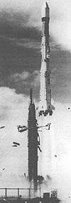
- GIOVE-B, built by Astrium and Thales Alenia Space, has a more advanced payload than GIOVE-A. It was successfully launched on 27 April 2008 at 22:16 GMT (4.16 a.m. (Baikonur time) aboard a Soyuz-FG/Fregat rocket provided by Starsem.
- The GIOVE-A2 satellite, to be built by SSTL, will be ready for launch in the second half of 2008, to ensure continuous reservation of Galileo frequency use with the ITU.[17]
From mid-2006, the GIOVE Mission[18][19] (GIOVE-M) segment is exploiting the GIOVE-A satellite to provide experimental results based on real data to be used for risk mitigation for the IOV satellites that will follow on from the testbeds. The GIOVE Mission will also provide experimentation results based on GIOVE-B and GIOVE-A2 satellites. The GIOVE Mission segment is operated by European Satellite Navigation Industries for the European Space Agency (ESA).
IOV Galileo satellites
These testbed satellites will be followed by four In-Orbit Validation (IOV) Galileo satellites that will be much closer to the final Galileo positioning satellite design.
Science projects using Galileo
In July 2006, an international consortium of universities and research institutions embarked on a study of potential scientific applications of the Galileo constellation. This project, dubbed GEO6, is a 360-degree study oriented to the scientific community in its broader sense, aiming to define and implement new applications of Galileo.
Among the various GNSS users identified by the Galileo Joint Undertaking, the GEO6 project addresses the Scientific User Community (UC).
The GEO6 project aims at fostering possible novel applications within the scientific UC of GNSS signals, and particularly of Galileo.
The AGILE project is an EU-funded project devoted to the study of the technical and commercial aspects of Location-based Services (LBS). It includes technical analysis of the benefits brought by Galileo (and EGNOS); also studying the hybridisation of Galileo with other positioning technologies (network-based, WLAN, etc.). Within these project, some pilot prototypes were implemented and demonstrated.
On the basis of the potential number of users, potential revenues for Galileo Operating Company or Concessionaire (GOC), international relevance, and level of innovation, a set of Priority Applications (PA) will be selected by the consortium and they will be developed within the time frame of the same Project.
These applications will help to increase and optimise the use of the EGNOS services as well as the opportunities offered by the Galileo Signal Test-Bed (GSTB-V2) and the Galileo (IOV) phase.
See also
- The European Satellite Navigation project was recently selected as the main motif of a very high value collectors' coin: the Austrian European Satellite Navigation commemorative coin, minted in 1 March 2006. The coin has a silver ring and niobium “pill”, colour gold-brown. In the reverse, the niobium portion depicts navigation satellites orbiting the Earth. The ring shows different means of transportation (an aeroplane, a container ship, a train and a truck) for which satellite navigation was developed.
- European Geostationary Navigation Overlay Service
- Commercialization of space
- Multilateration - the mathematical technique used for Galileo positioning
Notes and references
- ↑ BBC NEWS | Science/Nature | 'Unanimous backing' for Galileo
- ↑ http://www.physorg.com/news115630526.html
- ↑ http://www.guardian.co.uk
- ↑ US-EU Agreement on Galileo
- ↑ http://www.cnn.com/2007/TECH/05/08/galileo.troubles.ap/index.html EU: Galileo project in deep 'crisis'
- ↑ http://www.msnbc.msn.com/id/19750947/
- ↑ EU agrees 2008 budget to include Galileo financing — EUbusiness.com - business, legal and financial news and information from the European Union
- ↑ BBC NEWS | Science/Nature | Galileo 'compromise' is emerging
- ↑ BBC NEWS | Science/Nature | Galileo legal process ticks over
- ↑ China joins EU's satellite network - BBC News, 19 September 2003
- ↑ Press release
- ↑ Press release
- ↑ BBC NEWS | Science/Nature | 'Unanimous backing' for Galileo
- ↑ Selective Availability. Retrieved Aug 31, 2007.
- ↑ "DoD Permanently Discontinues Procurement Of Global Positioning System Selective Availability". DefenseLink (18 September 2007). Retrieved on 2007-12-17.
- ↑ Galileo System Test Bed Version 1 experimentation is now complete, ESA News release, 7 January 2005
- ↑ GIOVE-A2 to secure the Galileo programme, ESA News release, 5 March 2007
- ↑ GIOVE mission core infrastructure, ESA press release, 26 February 2007.
- ↑ One year of Galileo signals; new website opens, ESA press release, 12 January 2007.
- The Galileo Project – GALILEO Design consolidation, European Commission, 2003
- Guenter W. Hein, Jeremie Godet, et al: Status of Galileo Frequency and Signal Design, Proc. ION GPS 2002.
- Jean-Luc Issler, Gunter W. Hein, et al.: Galileo Frequency and Signal Design. GPS World, vol. 14, no. 6, June, 2003, pp. 30–37.
- Dee Ann Divis: Military role for Galileo emerges. GPS World, May 2002, Vol. 13, No. 5, p. 10.
- Dr Richard North: Galileo - The Military and Political Dimensions. 2004.
Further reading
- Psiaki, M. L., “Block Acquisition of weak GPS signals in a software receiver”, Proceedings of ION GPS 2001, the 14th International Technical Meeting of the Satellite Division of the Institute of Navigation, Salt Lake City, Utah, September 11-14, 2001, pp. 2838-2850.
- Bandemer, B., Denks, H., Hornbostel, A., Konovaltsev, A., “Performance of acquisition methods for Galileo SW receivers”, European Journal of Navigation, Vol.4, No. 3, pp 17-9, July 2006
External links
Official websites
- Official website – Europa
- European GNSS Supervisory Authority (GSA) – Europa
- Official website – ESA
Other
- News and Information – Host Europe
- The GEO6 project – Starlab Barcelona sl
- PACIFIC Project – PACIFIC
- GREAT project – EU-funded project to develop GALILEO Receivers for Mass Market Applications
- AGILE project – EU-funded project devoted to the analysis of LBS applications and how Galileo will contribute to enhance them
- u-blox 5 GALILEO GPS chips – First receivers to simultaneously track GPS and GALILEO satellites
Press coverage
- Green light for Galileo project - BBC News, 26 March 2002
- China joins EU's satellite network - BBC News, 19 September 2003
- EU-US strike sat-navigation deal - BBC News, 26 June 2004
- Galileo, fusion energy propel India, E.U. `strategic partnership' - The Hindu 9 November 2004
- Europe presses ahead on sat-navigation - BBC News, 10 December 2004
- Four Galileo spacecraft ordered - BBC News, 21 December 2004
- Dead heat for Galileo companies - BBC News, 1 March 2005
- Consortia combine to run Galileo - BBC News, 27 June 2005
- Q&A: Europe's Galileo project - BBC News, 26 December 2005
- Europe launches Galileo satellite - BBC News, 28 December 2005
- First Galileo signals received - BBC News, 13 January 2006
- First commercial Galileo receiver - EDN, 18 September 2006
- EU seeks input on use of Galileo navigation system - CBC, 11 December 2006
- Galileo System in Deep Crisis - BBC News, 8 May 2007
- Galileo Project in deep crisis - CNN, 8 May 2007
- Galileo firms miss key deadline BBC News, 10 May 2007
- EU looks to public funds for satellite system, CBC News, 10 June 2007
- Galileo demo sat to be despatched, BBC News, 6 March 2008
|
|||||||||||||||||
|
||||||||||||||
|
||||||||||||||||||||||||||||||||||||
|
|||||||||||||||||||||||||||||||||||||||||||||