Frisia
| Frisia | ||
|---|---|---|
 Frisian settlement area (Frisian Coast)
|
||
| Official languages | Frisian (Frysk, Frasch/Fresk/Freesk/Friisk, Saterland Frisian), Low German ((West Low German) East Frisian, Gronings), Dutch, German, Danish | |
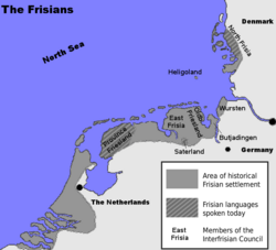
Frisia (West Frisian: Fryslân; North Frisian: Fraschlönj, Freesklöön, Freeskluin, Fresklun, and Friislön’; Saterfrisian (East Frisian): Fräislound; East Frisian Low Saxon: Freesland; Gronings: Fraislaand; German and Dutch: Friesland; Danish: Frisland) is a coastal region along the southeastern corner of the North Sea, i.e. the German Bight. Frisia is the traditional homeland of the Frisians, a Germanic people who speak Frisian, a language group closely related to the English language. Frisia extends from the northwestern Netherlands across northwestern Germany to the border of Denmark (Vidå).
Contents |
Divisions
Frisia is commonly divided into three sections:
- Province Friesland in the Netherlands (West Frisia)
- East Frisia in Lower Saxony
- North Frisia in Schleswig-Holstein
The three groups of the Frisian Islands (the West, East and North Frisian Islands) stretch more or less correspondingly along these three sections of the German Bight coast.
West Frisia corresponds roughly to the Dutch province of Friesland, the northern part of North Holland province (the historical region of West Friesland, the westernmost portion of the traditional region of West Frisia), and also modern Groningen province, though the Western Frisian language is only spoken in Friesland proper. Dialects with strong Frisian substrates, including Low German and Low Franconian, are also spoken in West Frisia. In the northern province of Groningen, people speak Gronings, a Low Saxon dialect with a strong Frisian substrate.
East Frisia includes areas located in the northwest of the German state of Lower Saxony, including the districts of Aurich, Leer, Wittmund and Friesland, as well as the urban districts of Emden and Wilhelmshaven, the Saterland, the Land Wursten a former Rüstringen (Butjadingen). East Frisia is also the name of a historical county in that area. The German name "Ostfriesland" distinguishes the former county from "Ost-Friesland", which means the whole eastern Frisian area.
The portions of North Frisia within the German state of Schleswig-Holstein are part of the district of Nordfriesland and stretch along the coast, including the coastal islands from the Eider River to the border of Denmark in the north. The North Sea island of Heligoland, while not part of Nordfriesland district, is also part of traditional North Frisia.
A half-million Frisians in the province of Friesland in the Netherlands speak West Frisian. Several thousand people in Nordfriesland and Heligoland in Germany speak a collection of North Frisian dialects that are often unintelligible to each other. A small number Saterland Frisian language speakers live in four villages in Lower Saxony, in the Saterland region of Cloppenburg county, just beyond the boundaries of traditional East Frisia. Many Frisians speak Low Saxon dialects, especially in East Frisia, but also in West and North Frisia.
History
Frisia has changed dramatically over time, both through floods and through a change in identity. It is part of the Nordwestblock which is a hypothetical historic region linked by language and culture.
Roman times
The Frisians began settling in Frisia around 500 BC. According to Pliny the Younger, in Roman times, the Frisians (or, as it may be, their close neighbours, the Chauci) lived on terps, man-made hills. According to other sources, the Frisians lived along a broader expanse of the North Sea (or "Frisian Sea") coast.
Frisia at this time comprised the present provinces of Friesland and North Holland.
Kingdom of Frisia

East Anglian sources called the inhabitants of 'Frisia' Warnii instead of Frisians. In the 7th and 8th centuries, the Frankish chronologies mention this area as the kingdom of the Frisians. However, these were probably not the Frisians of Roman times. This kingdom comprised the coastal provinces of the Netherlands and the German North Sea coast. During this time, the Frisian language was spoken along the entire southern North Sea coast and, today, this region is sometimes referred to as Greater Frisia or Frisia Magna. The 7th-century Frisian realm (650-734) under the kings Aldegisel and Redbad, had its centre of power in the city Utrecht. Its end came in 734 at the Battle of the Boarn, when the Frisians were defeated by the Franks, who then conquered the western part up to the Lauwers. They conquered the area east of the Lauwers in 785, when Charlemagne defeated Widukind. This Frisia Magna was partly occupied by Vikings in the 840s, until they were expelled between 885 and 920. It has also been suggested that the Vikings did not conquer Frisia, but settled in certain parts (such as the island of Wieringen), where they built simple forts and cooperated and traded with the native Frisians. One of their leaders was Rorik of Dorestad.

Loss of territory
Frisians made polders in West Friesland, which became more and more separated from Friesland due to floods. The western part of Frisia became the county of Holland in 1101, after a few centuries of a diverging history than the other parts. Frisia began to identify itself as a country with free folk in the Middle Ages. The bishopric of Utrecht no longer belonged to Frisia. There were many floods in the 11th and 12th centuries, which led to the deaths of many and eventually formed the Zuider Zee. The largest flood occurred in 1322.
Opstalboom League
The free Frisians (actually petty noblemen) and the city of Groningen founded the Opstalboom League to counter feudalism. The league consisted of modern Friesland, Groningen, East Frisia and the German North Sea coast, and parts of the Danish North Sea coast (Schleswig). But the Opstalboom league did not consist only of Frisians, as the area of Zevenwouden and the city of Groningen were Saxon. Some Frisians lived under the rule of the counts of Holland in West Friesland. The Opstalboom League was short-lived; it collapsed after a few years because of continual internal strife.
15th century
The 15th century saw the end of the free Frisians. The city of Groningen started to dominate Groningen. A petty nobleman in East Frisia managed to defeat the other petty noblemen and became count of East Frisia. The Archbishop of Bremen-Hamburg and the king of Denmark conquered large areas of Frisia. Only Friesland remained for the Frisian Freedom. Friesland was conquered in the 1490s by Duke Albert of Saxony-Meissen. Later, the giant Pier Gerlofs Donia (Grutte Pier) would fight for his country's freedom, wielding a 2,15 meter (7-foot) sword. He had many successes, but ultimately failed to secure Frisia's independence. He nonetheless gave himself the title King of the Frisians. He died a poor farmer in 1520.
Frisian territories
- West Friesland remained a part of Holland and became a part of North Holland around 1800. The current region of West Friesland is smaller than historical West Friesland and there is also an official constitutional region (samenwerkingsregio) of West Friesland for coast protection, the police, and agriculture.
- Friesland got its independence back (with constitutionalized farmer representation) in 1581 and gave it up for good in 1795. It is now a Dutch province.
- East Frisia became a part of the Kingdom of Prussia and was formerly a district of the federal state of Lower Saxony in the Federal Republic of Germany.
- Groningen has been a province of the Netherlands since the 16th century.
- North Frisia was a part of the Danish duchy of Schleswig (also: South Jutland) and belongs now to the German state of Schleswig-Holstein.
- The Frisian islands off the coast of the Netherlands and Germany are the leftover dunes of flooded lands.
Flag

Although the Frisian regions have their own separate flags, Frisia did not have a flag of its own until September 2006. The flag for united Frisia was made by the Groep fan Auwerk, which supports a united Frisia as an official country.
The flag, similar to the Norse and Icelandic flags, is inspired by the Nordic Cross Flag. The four pompeblêden (water lily leaves) refer to the seven pompeblêden on the (West) Friesland flag, but the number represents the three separate Frisian regions plus Groningen (Eastlauwersk Fryslân). The flag was not accepted by the Interfrisian Council and is just in use by the Groep[1].
See also
|
||||||||||||||||||||

Literature
- Albert Bantelmann, Rolf Kuschert, Albert Panten, Thomas Steensen: Geschichte Nordfrieslands. 2., durchges. u. aktualisierte Aufl., Westholst. Verlagsanstalt Boyens, Heide in Holstein 1996 (= Nordfriisk Instituut, Nr. 136), ISBN 3-8042-0759-6.
- Thomas Steensen: Geschichte Nordfrieslands von 1918 bis in die Gegenwart. Neuausg., Nordfriisk Instituut, Bräist/Bredstedt 2006 (= Geschichte Nordfrieslands, Teil 5; Nordfriisk Instituut, Nr. 190), ISBN 3-88007-336-8.
- Stefan Kröger - Das Ostfriesland-Lexikon. Ein unterhaltsames Nachschlagewerk, Isensee Verlag, Oldenburg 2006
- Ostfriesland im Schutze des Deiches. Beiträge zur Kultur- und Wirtschaftsgeschichte des ostfriesischen Küstenlandes, hrsg. im Auftrag der Niederemsischen Deichacht, 12 Bände, Selbstverlag, Pewsum u. a. 1969
- Onno Klopp -, Geschichte Ostfrieslands, 3 Bde., Hannover 1854–1858
- Hajo van Lengen - Ostfriesland, Kultur und Landschaft, ruhrspiegel-Verlag, Essen 1978
- Hajo van Lengen (Hrsg.) - Die Friesische Freiheit des Mittelalters – Leben und Legende, Verlag Ostfriesische Landschaft 2003, ISBN 3-932206-30-4
- Franz Kurowski - Das Volk am Meer – Die dramatische Geschichte der Friesen, Türmer-Verlag 1984, ISBN 3-87829-082-9
- Karl Cramer - Die Geschichte Ostfrieslands. Ein Überblick, Isensee - Oldenburg
- Hermann Homann - Ostfriesland – Inseln, Watt und Küstenland, F. Coppenrath Verlag, Münster
- Manfred Scheuch - Historischer Atlas Deutschland, ISBN 3-8289-0358-4
- Karl-Ernst Behre / Hajo van Lengen - Ostfriesland. Geschichte und Gestalt einer Kulturlandschaft, Aurich 1995, ISBN 3-925365-85-0
- Tielke, Martin (Hrsg.) - Biographisches Lexikon für Ostfriesland, Ostfries. Landschaftliche Verl.- u. Vertriebsges. Aurich, Bd. 1 ISBN 3-925365-75-3 (1993), Bd. 2 ISBN 3-932206-00-2 (1997), Bd. 3 ISBN 3-932206-22-3 (2001)