Free Territory of Trieste
|
|||||||||||||||||||||||||||||||||||||||||||||||

The Free Territory of Trieste or Free State of Trieste (Italian Territorio libero di Trieste, Slovenian Svobodno tržaško ozemlje, Croatian Slobodni teritorij Trsta) was a City state situated in Central Europe between northern Italy and Yugoslavia, created by the United Nations Security Council and administered by an appointed military governor commanding the peacekeeping forces stationed there.
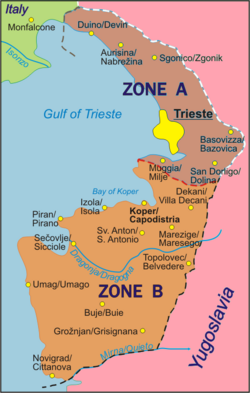
The Free State was established on 15 September 1947 by a protocol of the Italian Peace Treaty in order to accommodate an ethnically and culturally mixed population in a neutral country. The intention was also to cool down territorial claims between Italy and Yugosalvia, due to its strategic importance for trade with Central Europe. It was divided into two zones, one being the port city of Trieste with a narrow coastal strip to the north west (zone A), and the other a small portion of the Istrian peninsula (zone B).
The Free State was eventually taken over by its two neighbors in 1954 and officially dissolved in 1977.
Contents |
Geography

The Free Territory of Trieste comprised an area of 738 km² around the bay of Trieste from Duino/Devin in the north to Novigrad/Cittanova in the south and had approximately 330,000 inhabitants. It bordered Italy to the north and Yugoslavia to the south and east. The rivers of the territory included the Risano/Rižana, the Dragogna/Dragonja, the Timavo/Reka, the Rosandra/Glinščica and the Quieto/Mirna. The Territory's highest point was at Monte Castellaro/Veliko Gradišče (724m). Its most extreme points were near Medeazza/Medjevas at 45° 48’ in the north, at Porto Quieto/Tarski at 45° 18’ in the south, Punta Salvore/Rt Savudrija at 13° 29’ in the west and Grozzana di Pese/Gročana at 13° 55’ in the east.
History
For centuries, Trieste and Istria had been a part of the Austrian Empire, and later Austria-Hungary. The rural area was populated by Slovenes in the north and by Croats in the southeast, while Italians constituted the majority of inhabitants in Trieste, Rijeka and the towns of Istria.

In 1921 (after World War I) Italy formally annexed Trieste, Istria and part of what today is western Slovenia. In 1924 Italy further annexed the Free State of Fiume, now the city of Rijeka in Croatia.
During the 1920s and 1930s the Slavic population was subjected to Italianization and discrimination under the Italian Fascist regime. They were also exposed to violence, including the burning of the Slovene National Club (Narodni dom) in Trieste on July 13, 1920. Many Slovenes and Croats emigrated to Yugoslavia, while some joined the TIGR resistance organization, whose methods included more than 100, by some considered terrorist, actions in Trieste and surroundings during the 1920s and 1930s.
World War II
Italy fought with the Axis powers in World War II. When the Fascist regime collapsed in 1943 and Italy capitulated, Slovenia and Croatia (that were to become parts of the Yugoslavia) formally annexed the territory, but German forces occupied it. The Yugoslav 4th Army together with the Slovenian 9th Corps entered Trieste on May 1 1945. The 2nd Division (New Zealand) of the British 8th Army arrived on the next day and forced the surrender of 2,000 German Army troops holding out in Trieste. An uneasy truce developed between Allied and Yugoslav troops occupying the area until British Gen. Sir William D. Morgan proposed a partition of the territory and the removal of Yugoslav troops from the area occupied by the Allies. Tito agreed in principle on May 23 as the British XIII Corps was moving forward to the proposed demarcation line. An agreement was signed at Duino on June 10, creating the Morgan Line, and Yugoslav soldiers withdrew by June 12, 1945.
Establishment of the state

In January 1947 the United Nations approved a resolution under Article 24 of its charter calling for the creation of a free state in Trieste and the region surrounding it. A permanent statute codifying its provisions was to become recognized under international law upon the appointment of an international governor approved by the Quatripartite Powers. On September 15, 1947, the peace treaty between the United Nations and Italy was ratified, establishing the Free Territory of Trieste. Official languages were Slovenian and Italian. The territory was, however, divided into two zones: Zone A, which was 222.5 km² and had 262,406 residents including Trieste, which was administered by British and American forces, and Zone B, which was 515.5 km² with 71,000 residents including north-western Istria, and which was administered by the Yugoslav National Army.
Between October 1947 and March 1948 the Soviet Union rejected the candidacy of 12 nominations for governor, at which point the Tripartite Powers (United States, United Kingdom, and France) issued a note to Moscow and Belgrade on 20 March 1948 recommending that the territory be returned to Italian sovereignty. No governor was ever appointed under the terms of the UN Resolution. The Territory thus never functioned as a real independent state. Even so, its formal status was respected and it issued its own currency and stamps. The break between the Tito government and the USSR in mid-1948 resulted in the proposal to return the territory to Italy being suspended until 1953.
The Allied Military Government administered Zone A, which was divided into peacekeeping and law enforcement sectors protected by a command of 5,000 Americans ("TRUST", the TRieste United States Troops) and 5,000 British in "BETFOR" (British Element Trieste Forces|British Element Trieste FORce), each comprising a brigade-sized infantry force and complete support units (Signals, Engineers, Military Police, etc--TRUST included the 98th Army Band).
According to the estimates published by the Allied Military Government, as of 1949 in the A zone there were about 310,000 inhabitants, including 239,200 Italians and 63,000 Slovenes .
According to the Yugoslav census of 1945, in the part of Istria which was to become Zone B there were 67,461 inhabitants, including 30,789 Slavs, 29,672 Italians and 7,000 people of unidentified nationality. According to contemporary Italian sources, in zone B there were 36,000-55,000 Italians and 12,000-17,000 Slavs.
Dissolution
On 5 October 1954 a Memorandum of Understanding was signed in London by ministers of the United States, United Kingdom, Italy, and Yugoslavia. It gave a provisional civil administration of the former Zone A (with Trieste) to Italy and Zone B to Yugoslavia (which had already incorporated a communist government since 1947). In 1975 the Treaty of Osimo was signed in Osimo, definitively dividing the former Free Territory of Trieste between Italy and Yugoslavia.
Zone A corresponds to the current Italian Province of Trieste, and Zone B is now divided between the Slovenian Littoral and Croatian Istria.
Governors of Occupied Trieste and FTT
Zone A
- May 1, 1945 - July 1945 Maj. Gen. Bernard Cyril Freyberg (New Zealand) *
- July 1945 - July 1947 Col. Alfred Connor Bowman (United States)*
- July 1947 - September 16, 1947 Lt. Col. James J. Carnes (United States)*
- September 16, 1947 - May 31, 1951 Maj. Gen. Terence Sydney Airey (United Kingdom)
- May 31, 1951 - October 26, 1954 Maj. Gen. Thomas Winterton (United Kingdom)
Zone B
- May 1, 1945 - September 15, 1947 Dušan Kveder*
- September 15, 1947 - March 1951 Mirko Lenac
- March 1951 - October 26, 1954 Miloš Stamatović
*Military occupation prior to establishment of the FTT
- Source:Worldstatesmen / Italy / Trieste by Ben Cahoon
Demographics

During the late 1940s and in the years following the division of the territory, up to 40,000 people (mostly Italians) chose to leave the Yugoslav B zone and move to the A zone or Italy for various reasons - some were intimidated into leaving and some simply preferred not to live in Yugoslavia. In Yugoslavia, the people who left were called optanti which translates as choosing, while they call themselves esuli or exiles. About 14,000 Italians chose to remain in the Yugoslav zone, now part of Slovenia and Croatia.
See also
- Treaty of peace with Italy (1947)
- Communist Party of the Free Territory of Trieste
- United Nations Security Council Resolution 16
- Julian March
- Istrian exodus
- Morgan Line
- Slovene Littoral
- Province of Trieste
- Istria County