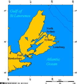
Fortress of Louisbourg
The Fortress of Louisbourg (in French, Forteresse de Louisbourg) is a Canadian National Historic Site and the location of a partial reconstruction of an 18th century French fortress at Louisbourg, Nova Scotia.
Contents |
Early history
French settlement on Île Royale (now Cape Breton Island) can be traced to the early 17th century following settlements in Acadia that were concentrated on Baie Français (now the Bay of Fundy) such as at Port-Royal and other locations in present-day peninsular Nova Scotia.
The settlement at Ste-Anne
A French settlement at Ste-Anne (now St. Anns) on the central east coast of Île Royale was established in 1629 and named Fort Ste-Anne, lasting until 1641. A fur trading post was established on the site from 1651–1659 but Île Royale languished under French rule as attention was focused on the St. Lawrence River/Great Lakes colony of Canada (which then comprised parts of what is now Quebec, Ontario, Michigan, Ohio, Indiana and Illinois), Louisiana (which encompassed the current Mississippi Valley states and part of Texas), and the small agricultural settlements of mainland Acadia.
The Treaty of Utrecht in 1713 gave Britain control of part of Acadia (peninsular Nova Scotia) and Newfoundland, however France maintained control of its colonies at Île Royale, Île St-Jean (now Prince Edward Island), and New France, with Île Royale being France's only territory directly on the Atlantic seaboard (now controlled by Britain from Newfoundland to Florida) and it was strategically close to important fishing grounds on the Grand Banks of Newfoundland, as well as being well placed for protecting the entrance to the Gulf of St. Lawrence.
Havre Louisbourg
In 1713, France set about constructing Port Dauphin and a limited naval support base at the former site of Fort Ste-Anne, however the winter icing conditions of the harbour led the French to choose another harbour on the extreme southeastern part of Île Royale. The harbour, being ice-free and well protected, soon became a winter port for French naval forces on the Atlantic seaboard and they named it Havre Louisbourg after the King.
Louisbourg - a fortified town

In 1719, France began construction on a fortified town located along the sheltered southwestern shore of Havre Louisbourg, naming the settlement Louisbourg. Construction would only be finished by the eve of the first British siege in 1745. The sheer volume of the French investment in construction and a growing economy based almost entirely on the Grand Banks fishery, coupled with some out-migration of Acadians living in the British colony now named Nova Scotia, soon saw the town of Louisbourg become a thriving community. The mounting costs for construction[1] also led to King Louis XV's famous musing to his ministers (to whom he had authorized the fortress's construction) if he should one day be able to see Louisbourg rising over the western horizon from his palace at Versailles.
Growth
As construction progressed and the settlement and its economy grew, Louisbourg soon became an important hub for commerce between France, New France, and French colonies in the West Indies. The town also became the base of a major fishery. To aid navigation to the often fog-bound harbour, the Louisbourg Lighthouse was constructed on the southeastern headland opposite the town in 1734, the first lighthouse in Canada. A cross-fire battery was planned at this location but never fully constructed.
First siege: 1745
The fortress was attacked in two major sieges the Siege of Louisbourg (1745) and the Siege of Louisbourg (1758). The first siege involved a New England force backed by a British Royal Navy Squadron. In an outcome that surprised most of Europe the New England attackers succeeded when the fortress capitulated on June 16, 1745. A major expedition by the French to recapture the Fortress led by Jean-Batiste De Roye de la Rochefoucauld Duc d'Enville the following year was destroyed by storms, disease and British naval attacks before it ever reached the fortress.
Louisbourg returned
The New Englanders' victory turned to disgust 3 years later when the Treaty of Aix-la-Chapelle, signed on October 18 1748 ended the War of the Austrian Succession and stipulated the restitution of the Fortress of Louisbourg to France by the English occupation force. The New England forces left, taking with them the famous Louisbourg Cross which had hung in the fortress chapel. This cross was only rediscovered in the Harvard University archives in the latter half of the 20th century; it is now on long-term loan to the Louisbourg historic site.
France, while not having control of the Atlantic seaboard (aside from the newly reinstated Île Royale), did control vast amounts of North America – far more than Britain. At the time of the Treaty of Aix-la-Chapelle, France claimed all territories from the Alleghenies to the Rockies and from the Gulf of Mexico to the North Pole, with the exception of the British-controlled territory around Hudson Bay. France also controlled the St. Lawrence River, the Great Lakes and the Mississippi River. And the French wanted to keep the British penned in on the Atlantic coast to prevent the separation of New France from their Louisiana territory.
Britain's response, in 1749, to the reinstatement of Louisbourg was to create their own fortified town on Chebucto Bay which they named Halifax. It soon became the largest Royal Navy base on the Atlantic coast and hosted large numbers of British army regulars as well including the 29th Regiment of Foot who cleared the land for the port and settlement.
Second siege: 1758
Britain's North American (American) colonies were getting restless and the efforts by French forces, with aid from their First Nations allies, to seal off the westward passes and approaches through which American colonists could move west soon led to the skirmishes which would develop into the French and Indian War in 1754 and devolve into the larger Seven Years' War by 1756, which also involved all the major European powers.
A large scale French naval deployment in 1757 fended off an attempted assault by the British in 1757. However inadequate naval support the following year allowed a large British combined operation to land for the 1758 Siege of Louisbourg which ended on July 26, 1758 with a French surrender. The fortress was destroyed by British engineers in 1760 to avoid its future use by the French and the site was abandoned at the end of the Seven Year's War.
National Historic Site
In 1961, the government of Canada, under the leadership of Victor Malm, undertook a historical reconstruction of one quarter of the town and fortifications with the aim being to recreate Louisbourg as it would have been at its height in the 1740s. The work required an interdisciplinary effort by archaeologists, historians, engineers, and architects. The reconstruction was aided by unemployed coal miners from the Industrial Cape Breton area, many of whom learned French masonry techniques from the 18th century and other skills to create an accurate replica. Where possible, many of the original stones were used in the reconstruction.
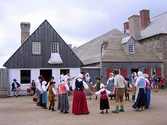
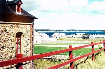
Today, the entire site of the Fortress of Louisbourg, including the one-quarter reconstruction, has been designated a National Historic Site with guided and unguided tours available. Also available at the site are weapons explanations and demonstrations; these include the firing of muskets and a cannon. Puppet shows are also shown. The fortress has also greatly aided the local economy of the town of Louisbourg as it has struggled to diversify economically with the decline of the North Atlantic fishery.
References
- Louisbourg: From its Foundation to is Fall J.S. McLennan (1918)
- Endgame A.J.B. Johnson (2008)
- The Great Fortress : A chronicle of Louisbourg 1720-1760 William Wood
- text version from Project Gutenberg
- audiobook from LibriVox
- The Taking of Louisburg 1745 by Samuel Adams Drake, Lee and Shepard Publishers Boston Mass. USA 1891 (reprinted by Kessinger Publishing ISBN 9780548622346)
External links
- Fortress of Louisbourg National Historic Site - Parks Canada
- Louisbourg Institute
- Account of New England vessels used against Louisbourg in 1745
- An essay on Fortress Louisbourg
|
|||||||||||||||||||||||||||||||