Exeter
| City of Exeter | |
| Exeter | |
|
|
|
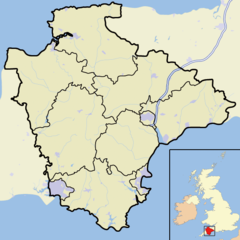 City of Exeter shown within Devon |
|
| Population | 122,400. (Mid-2007 Pop Estimates. ONS, Crown Copyright). |
|---|---|
| OS grid reference | |
| - London | 196 miles (315 km) |
| District | Exeter |
| Shire county | Devon |
| Region | South West |
| Constituent country | England |
| Sovereign state | United Kingdom |
| Post town | EXETER |
| Postcode district | EX1-6 |
| Dialling code | 01392 |
| Police | Devon and Cornwall |
| Fire | Devon and Somerset |
| Ambulance | South Western |
| European Parliament | South West England |
| UK Parliament | Exeter |
| Website: http://www.exeter.gov.uk/ | |
| List of places: UK • England • Devon | |
Exeter (pronunciation (IPA ˈeksɪtər) is a city, district and county town of Devon, England. Exeter is located approximately 37 miles (60 km) northeast of Plymouth, and 70 miles (110 km) southwest of Bristol, on the River Exe. The city has a population of 111,076 according to the 2001 Census.
Exeter was the most south-westerly Roman fortified settlement in Britain and has existed since time immemorial. Exeter Cathedral, founded in 1050 is Anglican.
Tourism forms a vital part of the city's economy, and in 2004 Exeter was granted Fairtrade City status. Exeter has been identified as one of the top ten most profitable locations for a business to be based, and has a sizable service economy, with a catchment workforce of 300,000 people within a 45 minute commute.[1] The city has good transport links, with Exeter Central railway station, Exeter St David's railway station, the M5 motorway and Exeter International Airport connecting the city both nationally and internationally.
Contents |
History
Roman times


.
The Latin name for Exeter, Isca Dumnoniorum ("Isca of the Dumnones"), suggests that the city was of Celtic origin. This oppidum, (a Latin term meaning an important town), on the banks of the River Exe certainly existed prior to the foundation of the Roman city in about AD 50, however the name may have been suggested by a Celtic adviser to the Romans, rather than by the original inhabitants of the place.
Such early towns, or proto-cities, had been a feature of pre-Roman Gaul as described by Julius Caesar in his Commentarii de Bello Gallico ("Commentaries on the Gallic Wars") and it is possible that they existed in neighbouring Great Britain as well. Isca is clearly a Celtic generic noun and the Romans felt the need to name the city Isca Dumnoniorum in order to distinguish it from such settlements as Isca Augusta (modern Caerleon-on-Usk in Monmouthshire).
Significant parts of the Roman wall remain, though the present visible structure was largely built on the orders of Alfred the Great to protect the far west of his kingdom following the Viking occupation of 876. Most of its route can be traced on foot. There is a substantial Roman baths complex that was excavated in the 1970s,[2][3] but because of its proximity to the cathedral, it has not been practicable to retain the excavation for public view. Exeter was also the southern starting point for the Fosse Way Roman road.
Saxon times
In 876 Exeter (Exanceaster) was attacked and captured by the Danes. King Alfred (Alfred the Great) drove them out the next year. In 894 the city held off another siege by the Danes. However, the city fell to the Danes a second time in 1001. In 927 Athelstan drove the south west Celts out of the walled city of Exeter.
In 1067 the city rebelled against William the Conqueror who promptly marched west and laid siege. The city submitted after only 18 days. Part of the capitulation agreement was that all the nobles in the city would be confirmed in their positions as long as a castle was built.
Medieval times
Exeter was held against King Stephen by Baldwin de Redvers in 1140 and submitted only after a three month siege when the supplies of fresh water ran out.
Tudor and Stuart times

In 1537, the city was made a county corporate. In 1549 the city successfully withstood a month-long siege by the Prayer Book rebels. The Livery Dole Almshouses and Chapel at Heavitree were founded in March 1591 and finished in 1594. They can still be seen today in the street which bears the name Livery Dole.
The city's motto, Semper fidelis, is traditionally held to have been suggested by Elizabeth I, in acknowledgement of the city's contribution of ships to help defeat the Spanish Armada in 1588.[4]
Exeter was at first a Parliamentary town in the English Civil War in the largely Royalist South West, but it was captured by the Royalists on 4 September 1643 and it remained in their control until near the end of the war, being one of the final Royalist cities to fall into Parliamentary hands. During this period, Exeter was an economically powerful city, with a strong trade of wool. This was partly due to the surrounding area which was "more fertile and better inhabited than that passed over the preceding day" according to Count Lorenzo Magalotti who visited the city when he was 26 years old.[5] Magalotti writes of over thirty thousand people being employed in the county of Devon as part of the wool and cloth industries, merchandise that was sold to "the West Indies, Spain, France and Italy".[6] Celia Fiennes also visited Exeter during this period, in the early 1700s. She remarked on the "vast trade" and "incredible quantity" in Exeter, recording that "it turns the most money in a week of anything in England", between £10,000—£15,000.[7]
Georgian and Victorian times

Early in the Industrial Revolution, Exeter's industry developed on the basis of locally available agricultural products and, since the city's location on a fast-flowing river gave it ready access to water power, an early industrial site developed on drained marshland to the west of the city, at Exe Island. However when steam power replaced water in the 19th century, Exeter was too far from sources of coal (or iron) to develop further. As a result the city declined in relative importance, and was spared the rapid 19th century development that changed many historic European cities. Extensive canal redevelopments during this period further expanded Exeter's economy, with "vessels of 15 to 16 tons burthen [bringing] up goods and merchandise from Topsham to the City Quay".[8]
The first railway to arrive in Exeter was the Bristol and Exeter Railway that opened a station at St Davids on the western edge in 1844. The South Devon Railway Company extended the line westwards to Plymouth, opening their own smaller station at St Thomas, near the lower end of Fore Street. A more central railway station, that at Queen Street, was opened by the London and South Western Railway in 1860 when it opened its alternative route to London.
Wartime and post-war times

Exeter was bombed by the German Luftwaffe in the Second World War, when a total of 18 raids between 1940 and 1942 flattened much of the city centre. In 1942, as part of the Baedeker Blitz and specifically in response to the RAF bombing of Lubeck, forty acres (160,000 m²) of the city, particularly adjacent to its central High Street and Sidwell Street, were levelled by incendiary bombing. Many historic buildings were destroyed, and others, including the grand Cathedral of St Peter in the heart of the city, were damaged.
Large areas of the city were rebuilt in the 1950s, when little attempt was made to preserve Exeter's ancient heritage. Damaged buildings were generally demolished rather than restored, and even the street plan was altered in an attempt to improve traffic circulation. The post-war buildings are generally perceived as being of little architectural merit, unlike many of those that they replaced, such as Bedford Circus and a section of the ancient city wall.
Despite some local opposition,[9] the Princesshay shopping centre has been redeveloped between the Cathedral Close and the High Street. The development was completed and opened on time on 20 September 2007.[10][11] There are 123 varied residential units incorporated into the new Princesshay[12] .
In order to enable people with limited mobility to enjoy the city, Exeter Community Transport Association provides shopmobility[13] for use by anyone suffering from short or long-term mobility impairment to access to the city centre and shopping facilities, events and meetings with friends and company.
Previously regarded as second only to Bath as an architectural site in southern England, since the 1942 bombing and subsequent reconstruction Exeter has been a city with some beautiful buildings rather than a beautiful city. As a result, although there is a significant tourist trade, Exeter is not dominated by tourism. In May 2008 there was an attempted terrorist attack in Princesshay.
Governance
Exeter forms a single parliamentary constituency. It is relatively marginal, and since World War II its Member of Parliament has usually been drawn from the governing party. At the United Kingdom general election, 1997, Ben Bradshaw was elected as MP for Exeter, and he retained the seat at the elections of 2001 and 2005. Exeter is part of the South West England European constituency, which elects 7 MEPs.
Exeter's city council is a district authority, and shares responsibility for local government with the Devon County Council. Since 2003, no party has had a majority on the council.
Exeter has had a mayor since at least 1207 and until 2002, the city was the oldest 'Right Worshipful' Mayoralty in England. As part of the Queen's 2002 Golden Jubilee celebrations Exeter was chosen to receive the title of Lord Mayor. Councillor Granville Baldwin became the first Lord Mayor of Exeter on 1 May 2002 when Letters Patent were awarded to the city during a visit by the Queen.
The Lord Mayor is elected each year from amongst the 40 Exeter city councillors and is non-political for the term of office.
Devon and Cornwall Constabulary have their headquarters based at Middlemoor in the east of the city.
Geography
The city of Exeter was established on the eastern bank of the River Exe on a ridge of land backed by a steep hill. It is at this point that the Exe, having just been joined by the River Creedy, opens onto a wide flood plain and estuary which results in quite common flooding. Historically this was the lowest bridging point of the River Exe which was tidal and navigable up to the city until the construction of weirs later in its history. This combined with the easily defensible higher ground of the ridge made the current location of the city a natural choice for settlement and trade. In George Oliver's The History of the City of Exeter, it is noted that the most likely reasons for the original settling of what would become modern Exeter was the "fertility of the surrounding countryside" and the area's "beautiful and commanding elevation [and] its rapid and navigable river".[14] Its woodland would also have been ideal for natural resources and hunting.
Exeter sits predominantly on sandstone and conglomerate geology, although the structure of the surrounding areas is varied.[15] The topography of the ridge which forms the backbone of the city includes a volcanic plug, on which the Rougemont Castle is situated. The Cathedral is located on the edge of this ridge and is therefore visible for a considerable distance.
Climate
| Month | Jan | Feb | Mar | Apr | May | Jun | Jul | Aug | Sep | Oct | Nov | Dec | Year |
|---|---|---|---|---|---|---|---|---|---|---|---|---|---|
| Average high °C (°F) | 9.0 (48) |
8.9 (48) |
10.5 (51) |
12.2 (54) |
15.3 (60) |
18.2 (65) |
20.6 (69) |
20.4 (69) |
18.2 (65) |
14.8 (59) |
11.7 (53) |
9.9 (50) |
14.2 (58) |
| Average low °C (°F) | 3.7 (39) |
3.5 (38) |
4.6 (40) |
5.7 (42) |
8.6 (47) |
11.2 (52) |
13.5 (56) |
13.4 (56) |
11.4 (53) |
8.9 (48) |
6.0 (43) |
4.8 (41) |
8.0 (46) |
| Precipitation mm (inches) | 101.8 (4.01) |
82.7 (3.26) |
68.1 (2.68) |
54.8 (2.16) |
52.0 (2.05) |
51.0 (2.01) |
36.4 (1.43) |
56.9 (2.24) |
66.5 (2.62) |
83.2 (3.28) |
83.8 (3.3) |
112.8 (4.44) |
850.0 (33.46) |
| Source: Met Office[16] 2008-03-08 | |||||||||||||
Demographics
The city has been expanding in size quite considerably in recent years, with a population estimate of 119,600 in 2006, up over 8,000 from the census in 2001. The racial makeup of the city is as follows (2005 Estimates):[17]
- White - 97.5%
- Asian - 1.4% (0.7% Indian, 0.4% Other, 0.2% Pakistani, 0.2% Bangladeshi)
- Mixed Race - 1.1% (0.4% Asian and White, 0.3% Black and White, 0.3% Other Mixed)
- Chinese - 0.6%
- Black - 0.4% (0.2% African,0.1% Caribbean,0.1% Other)
- Other - 0.5%
In the 2004-05 period the population of "White Other" increased by 24% from 2.9% to 3.6%[18] - higher than any other town or city in the United Kingdom.
Economy
The city provides strong industries and services to a sizable area. The Met Office, the main weather forecasting organisation for the United Kingdom and one of the most significant in the world, relocated from Bracknell in Berkshire to Exeter in early 2004. It is one of the three largest employers in the area (the others being the University of Exeter and Devon County Council), providing a welcome boost to the local economy.
Exeter City Council is currently bidding for the city to become an Independent Unitary Authority, a status granted to nearby Plymouth and Torbay in 1998. An outline case was submitted to the Secretary of State for Communities and Local Government in May 2006. If successful, a new unitary city council could be up and running in Exeter by April 2009.
On 26 June 2004, Exeter was granted Fairtrade City status.
A NEF survey in 2005 rated Exeter as the worst example of a clone town in the UK, with only a single independent store in the city's High Street, and less diversity (in terms of different categories of shop) than any other town surveyed. However, Exeter has many independent shops off High Street such as those in Gandy Street, which was reconstructed after bombing in 1942.
Princesshay, a post-war retail area running parallel to High Street was also home to a number of independent stores prior to redevelopment in 2007. It is an innovative varied development and it is still intended that a number of the new units will be let to local independent stores.
Landmarks

Among the notable buildings in Exeter are:
- The cathedral, founded in 1050 when the bishop's seat was moved from the nearby town of Crediton (birthplace of Saint Boniface) because Exeter's Roman walls offered better protection against "pirates", presumably Vikings. A statue of Richard Hooker, the 16th century Anglican theologian, who was born in Exeter, has a prominent place in the Cathedral Close.
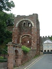
- The ruins of Rougemont Castle, built soon after the Norman Conquest; later parts of the castle were still in use as an Assize court until early 2006 when a new Crown Courts building opened. A plaque near the ruined Norman gatehouse recalls that in 1685 Alice Molland, the last person executed for witchcraft in England, was imprisoned in Exeter. The future of the castle is at the moment uncertain, but moves are afoot to alter its use, possibly to a restaurant and housing.
- The Guildhall, the oldest municipal building in England still in use.
- Mols Coffee House Historic building in the Cathedral close.
- The Guild of Tuckers and Weavers, a fine old building that is still used for smart functions.
- The Custom House in the attractive Quay area, which is the oldest brick building surviving in the city.
- St Nicholas Priory in Mint Lane, the remains of a monastery, later used as a private house and now a museum owned by the city council.
- A number of medieval churches including St Mary Steps which has an elaborate clock.
- "The House That Moved", a 14th century Tudor building, earned its name in 1961 when it was moved from its original location on the corner of Edmund Street in order for a new road to be built in its place. Weighing more than twenty-one tonnes, it was strapped together and slowly moved a few inches at a time to its present day position.
- Parliament Street in the city centre is one of the narrowest streets in the United Kingdom (see photograph).
- The Butts Ferry, an ancient cable ferry across the River Exe.
Many of these are built in the local dark red sandstone, which gives its name to the castle and the park that now surrounds it (Rougemont means red hill).
Northernhay Gardens located just outside the castle, is the oldest public open space in the whole of England, being originally laid out in 1612 as a pleasure walk for Exeter residents. Much of Northernhay Gardens now represent Victorian design, with a beautiful display of trees, mature shrubs and bushes and plenty of flower beds. There are also many statues here, most importantly the war memorial by John Angel and the Deerstalker by E.B. Stephens. The Volunteer Memorial from 1895, also in the gardens, commemorates the formation of the 1st Rifle Volunteers in 1852. Other statues include John Dinham, Thomas Dyke Acland and Stafford Northcote (a local landowner who was a Victorian Chancellor of the Exchequer).
Transport
The M5 motorway to Bristol and Birmingham starts at Exeter, and connects at Bristol with the M4 to London and South Wales. The older A30 road provides a more direct route to London via the A303 and M3. The M5 is the modern lowest bridging point of the River Exe. Going westwards, the A38 connects Exeter to Plymouth and south east Cornwall, whilst the A30 continues via Okehampton to north and west Cornwall. Travel by car in the city is often difficult with regular jams centred on the Exe Bridges area. To address the problem, Devon County Council is considering the introduction of congestion charges.[19]
Exeter's main operator of local buses is Stagecoach Devon, which operates most of the services in the city. Dartline is a minor operator in the City. Former Cooks Coaches were taken over by Stagecoach forming Stagecoach Cooks Coaches. Western Greyhound is also a main operator connecting Exeter to Cornwall, Somerset and many different places in South West England. High Street, pedestrianised except for bus and bicycle traffic, serves as the main hub for local buses. Country and express services operate from the city's bus station, in Paris Street, which intersects High Street at its eastern end; some also call at Exeter St Davids railway station for direct connection to train services. Country bus services, mostly operated by Stagecoach, run from Exeter to most places in East and North Devon, but some are very infrequent. Regional express services run to Plymouth, Torbay, Bude, and along the Jurassic Coast to Lyme Regis and Weymouth, some operated by Stagecoach and others by First Bus. National Express operates long distance routes, for example to Heathrow and London.
There are two main line railway routes from Exeter to London, the faster route via Taunton to London Paddington and the slower West of England Main Line via Salisbury to London Waterloo. Another main line, the Cross-Country Route, links Exeter with Bristol, Birmingham, the Midlands, Northern England, and Scotland. Many trains on all three lines continue westwards from Exeter, variously serving Torbay, Plymouth and Cornwall. Local branch lines run to Paignton (see Riviera Line), Exmouth (see Avocet Line) and Barnstaple (see Tarka Line). There is also a summer weekend service to Okehampton for access to Dartmoor. Exeter is served by two main railway stations. Exeter St Davids is served by all services, whilst Exeter Central is more convenient for the city centre but served only by local services and the main line route to London Waterloo. There are also six suburban stations, Topsham, St James Park, Exeter St Thomas, Polsloe Bridge, Pinhoe and Digby & Sowton, served only by local services.
Exeter International Airport lies east of the city and the local airline, previously called Jersey European and British European but now known as Flybe, is a significant local employer. The airport offers a range of scheduled flights to UK and Irish regional airports and charter flights including a seasonal service to Toronto, Canada. Connections to international hubs began with Paris Charles de Gaulle in 2005 and later a daily service to Amsterdam Schiphol Airport.
The Exeter Canal was built in 1558, making it one of the oldest artificial waterways in Britain. It was cut to bypass weirs that had been built across the River Exe to prevent trade in the city and to force boats to unload at Topsham from where the Earls of Devon were able to exact large tolls to transport goods to Exeter. Originally 3 feet deep and 16 feet wide (0.9 m by 5 m), it ran 1.75 miles (2.8 km) from just below the Countess Weir to the centre of Exeter. It was later extended to Topsham, deepened and widened, and was successful until the middle of the 19th century since when its use gradually declined - the last commercial use was in 1972. However it is now widely used for leisure purposes, and the city basin is being included as part of a £24 million redevelopment scheme.
Education
- The University of Exeter has two campuses in the city, both notable for their attractive parkland. It is one of the largest employers in the city.
- Exeter is one of the four main sites of the University of Plymouth
- The Peninsula Medical School, a joint operation of the two universities, has one of its main sites in Exeter
- St Loye's School of Health Studies, well-known for training in occupational therapy has now been incorporated into the University of Plymouth.
- Exeter College is a major further education college. It operates as a sixth form for the entire maintained school sector in the city.
- For about 30 years the city of Exeter operated a maintained school system in which the divisions between phases came at different ages from most of the United Kingdom, with first, middle and high rather than infant, junior and secondary schools, so that children transferred between schools at the age of about 8 and 12 rather than 7 and 11. From 2005, however, it has adopted the more usual pattern, because of the pressures of the UK National Curriculum.
The changeover back from the structure led to a city wide, PFI funded, rebuilding programme for the high schools and led to the changing of names for some schools. Following the reorganisation there are 25 primary schools, 4 referral schools, 3 special schools and 5 secondary schools within Exeter.[20] The secondary schools are:
- Isca College of Media Arts (formerly Priory High School)
- St James' School (formerly St James' High School)
- St Luke's (Church of England) Science & Sports College (formerly Vincent Thompson High School)
- St Peter's Church of England Aided School - A Language College
- West Exe Technology College (formerly St Thomas High School)
In addition:
- Exeter School[21] is the oldest of several public schools in the city.
- Exeter is home to several substantial language schools
- Exeter is also home to the Royal West of England School for the Deaf & the West of England School for the Partially Sighted.
- The Atkinson Unit is a secure specialist residential and educational complex for children in care or remanded by the courts.
Religion
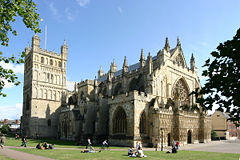
There are many churches in Exeter belonging to different Christian movements and an Anglican cathedral. It is the seat of the Bishop of Exeter. The present building was complete by about 1400, and has the longest uninterrupted vaulted ceiling in England, and other notable features. There is also a synagogue on Mary Arches Street. Muslims and other Asian religious groups are believed to number less than 600.
Sports
- Exeter's football club, Exeter City, were relegated from the Football League in 2003 after 83 years' membership. Exeter lost 2-1 in the Conference play-off final to Morecambe FC at Wembley Stadium on Sunday 20 May 2007, missing out on promotion to the Football League. They have recently been promoted back into the Football League with a 1-0 play-off final win against Cambridge United also at Wembley.
- Rugby Union is popular in the South West: Exeter's clubs are the Exeter Chiefs[22] (who currently play in National Division One and were runners-up in the 2007/08 season), Wessex and Exeter Saracens.[23]
- Exeter Cricket Club play in the Premier Division of the Devon Cricket League at both First and Second XI level.
- The University of Exeter has a strong reputation in sport and regularly wins or comes close to winning national trophies in inter-university sports.
- Exeter rowing Club enjoys much success both locally and nationally, and has a recorded history stretching back to the early 1800s.
- The Devon & Exeter Squash club is one of the most active squash clubs in the region, annually hosting the Exeter Diamonds which is a professional team of world class players. The club also has a strong membership, high standards and a notably junior team.
- The Great West Run half marathon is run through the streets of Exeter in late April each year
- Exeter's speedway team, Exeter Falcons, was founded in 1929 and were located at the County Ground until its closure in 2005. In a fixture during the 2004 season, they beat Rye House by the maximum score of 75-18 scoring 5-1s in every heat. Exeter Falcons are hoping to ride again in a proposed new location, possibly at Exeter Racecourse in 2008. The site was where Exeter Falcons legend Australian Jack Geran trained youngsters in the art of the shale sport on a speedway training track in the late 1970s and early-1980s.
Speedway was also staged briefly at tracks in Alphington and Peamore after the Second World War. The history of Speedway in Exeter up to the mid-1950s has been recorded in three books by Tony Lethbridge.
Public services
Home Office policing in Exeter is provided by The Devon and Cornwall Constabulary. The emergency fire brigade is provided by The Devon and Somerset Fire and Rescue Service, which is headquartered at Clyst St. George near Exeter. It has one fire station with two water tender ladders, a water tender, an aerial ladder platform, a water foam carrier, a handyman vehicle, a prime mover, an environmental pod and an incident support unit.
The Royal Devon and Exeter NHS Foundation Trust has a large hospital located to the south east of the city centre. Ambulance services in Exeter are provided by South Western Ambulance Service NHS Trust. The West Trust Divisional HQ and 999 control is in Exeter which provides cover for Devon and Cornwall.
Notable people from Exeter
- See List of people from Exeter
Culture
Literature

The Exeter Book, an original manuscript and one of the most important documents in Anglo-Saxon literature, is kept in the vaults of Exeter Cathedral. The Exeter Book dates back to the 10th century and is one of four manuscripts that between them contain virtually all the surviving poetry in Old English. It includes most of the more highly regarded shorter poems, some religious pieces, and a series of riddles, a handful of which are famously lewd. Some of the riddles are inscribed on a highly polished steel obelisk in High Street, placed on 30 March 2005.
The Inquisitio Eliensis, the "Exon Domesday" (so called from the preservation of the volume at Exeter), is a volume of Domesday Book that contains the full details which the original returns supplied.
One of Rosemary Sutcliff's best-known children's books, The Eagle of the Ninth, begins in Roman Isca Dumnoniorum.
The Crowner John Mysteries by Bernard Knight are a series of books set in 12th century Exeter.
Theatre
The Northcott Theatre is located on the campus of the university and is one of relatively few provincial English theatres to maintain its own repertory company. Its annual open air Shakespeare performance in the grounds of Rougemont Castle is well regarded nationally. This theatre is the successor to the former Theatre Royal, Exeter.

There are also two amateur theatre buildings with associated companies. The Barnfield Theatre, in the city centre, was converted in 1972 from The Barnfield Hall which was built towards the end of the 19th century by Exeter Literary Society. The theatre is a charity and is used as a venue for amateur and professional theatrical companies. In January 2007 it received £200,000, about the same as the original cost to build it, to refurbish its interior.
Theatrical productions and other stage performances frequently take place at the Phoenix Arts Centre off Gandy Street.
Music
Exeter has a diverse and thriving music scene for a city of its size.
- Phonic FM, the community radio station, features local DJs, live broadcasts from gigs around Exeter, interviews with artists and guests.
- The Phoenix centre is regularly host to live music and DJs in many genres
- The Cavern Club in Queen Street is a popular venue for live punk, indie and underground dance music.
- The Hub in Mary Arches street is also a popular live music venue.
- Amber Rooms on Sidwell Street holds dance and alternative world beats nights.
- The Globe Inn on Clifton Road in Newtown holds live events most nights (including world music, open mic nights and local rock bands).
- Timepiece has 3 floors, with various discounts available with student union card
- Exeter does not have a resident professional orchestra, but the Bournemouth Symphony Orchestra tours to the city regularly.
- The largest orchestra based in Exeter is the EMG Symphony Orchestra[24] which presents regular concerts at the University of Exeter and in Exeter Cathedral.
- Exeter Children's Orchestra is a youth orchestra with patrons Marin Alsop and Sir Colin Davis
- Kagemusha Taiko is a drumming ensemble that combines theatrical performance with excellent drumming
- The cathedral choir is nationally known, and the cathedral is frequently the venue for concerts by visiting orchestras.
- There are two Festivals each year, of all the arts but with a particular concentration of musical events
- The annual "Vibraphonic" festival held in the spring provides a fortnight of soul, blues, jazz, funk, reggae and electronic music. A radio station, Vibraphonic FM, runs for a month around the festival.
- Children of the Drone is an improvisational music collective, based in Exeter since 2001
- Exeter has held a "Respect Festival" since 2002 to promote cultural differences and that they need to be accepted and not discriminated.
- Exeter is the home of Mansons Guitar Shop and is where Matthew Bellamy of MUSE gets his guitars custom made.
Museums and galleries
- The city museum is the Royal Albert Memorial Museum in Queen Street. The Museum also runs St Nicholas Priory which is just off Fore street.
- The Phoenix Arts Centre and Phoenix Media Centre occupies the former university site in Gandy Street.
- Spacex is a long established modern art gallery
Newspapers
- Exeter List Website, is a monthly 'what's on' listings guide for Exeter and the Heart of Devon. Exeter's Essential Guide.Exeter list
- Express and Echo, daily (current)
- The Exeter Times, formerly known as the Exeter Leader, weekly, free
- Flying Post, weekly (discontinued 1917, but title revived in 1975 as an alternative (polemical) community magazine)
- The Western Morning News, a Plymouth-printed daily regional paper, is also popular
Twinnings
Exeter is twinned with:
The city also seeks to maintain a relationship with HMS Exeter.
See also
- Exeter Book
- Exeter (HM Prison)
- Henry Phillpotts
References
- ↑ Dun & Bradstreet, 2001
- ↑ "Great Sites: Exeter Roman Baths". British Archaeology magazine (June 2002). Retrieved on 2008-07-12.
- ↑ "The Roman Fortress at Exeter: The Roman Bath House". Retrieved on 2008-07-12.
- ↑ "Exeter's Coat of Arms". Exeter City Council website. Retrieved on 2008-07-13.
- ↑ Gray, Todd (2000). Exeter: The Traveller's Tales. pp. 16. ISBN 1903356008.
- ↑ Gray, Todd (2000). Exeter: The Traveller's Tales. pp. 18. ISBN 1903356008.
- ↑ Gray, Todd (2000). Exeter: The Traveller's Tales. pp. 31. ISBN 1903356008.
- ↑ Oliver, George (1861). History of the City of Exeter. pp. 107.
- ↑ "High Street revamp plans criticised". BBC News. Retrieved on 2007-09-21.
- ↑ "Doors open at Princesshay". BBC Devon (2007-09-20). Retrieved on 2007-09-21.
- ↑ "Heaven for shoppers as Princesshay gets off to a flying start with huge crowds for opening day", Express & Echo (2007-09-21). Retrieved on 2007-09-21.
- ↑ "Key facts about Princesshay". Princesshay.com. Land Securities Group. Retrieved on 2007-09-21.
- ↑ "Shopmobility". Exeter Community Transport Association. Retrieved on 2008-07-13.
- ↑ Oliver, George (1861). History of the City of Exeter. pp. 1.
- ↑ DEFRA. "Southwest EDRP Geographical Area and Physical Context". Retrieved on 2008-07-13.
- ↑ "Teignmouth 1971–2000 averages". Met Office. Retrieved on 2008-03-08.
- ↑ "Resident Population Estimates by Ethnic Group (Percentages), Area: Exeter (Local Authority)". Office for National Statistics. Retrieved on 2008-07-13.
- ↑ "Exeter, Resident Population Estimates by Ethnic Group". Office for National Statistics. Retrieved on 2008-07-19.
- ↑ "Drivers facing congestion charge". BBC News Online (2006-11-07). Retrieved on 2008-07-13.
- ↑ "Schools, locations and details". Devon County Council website. Retrieved on 2008-07-19.
- ↑ "Exeter School Website". Retrieved on 2008-07-19.
- ↑ "Exeter Chiefs Website". Retrieved on 2008-07-19.
- ↑ "Exeter Saracens Rugby Football Club Website". Retrieved on 2008-07-19.
- ↑ "EMG Symphony Orchestra website". Retrieved on 2008-07-19.
The Cathedral Town, Time-Travel Britain [Clayton Trapp], http://www.timetravel-britain.com/articles/towns/exeter.shtml
External links
- Exeter City Council
- Photographs of Exeter
- Exeter Memories includes film and photo essays
- History of Exeter from White's Devonshire Directory, 1850
- Exeter Hotel and information portal
- Exeter (DMOZ.org)
- ExeterViews, Information site / visitor guide
- Exeter on Wikitravel
- Exeter's community radio station, Phonic FM
- Southwest Underground: Information on Exeter's music scene
|
|||||
|
||||||||||||||
|
||||||||||||||||||||