Ellesmere Island
 |
|
| Geography | |
|---|---|
| Location | Northern Canada |
| Archipelago | Queen Elizabeth Islands |
| Area | 196,235 km2 (75,767 sq mi) (10th) |
| Highest point | Barbeau Peak (2,616 m (8,580 ft)) |
| Country | |
| Territory | |
| Largest city | Grise Fiord (141) |
| Demographics | |
| Population | 146 (as of 2006) |
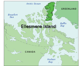
Ellesmere Island is part of the Qikiqtaaluk Region of the Canadian territory of Nunavut. Lying within the Canadian Arctic Archipelago it is considered part of the Queen Elizabeth Islands, with Cape Columbia being the most northerly point of land in Canada. It comprises an area of 196,235 km2 (75,767 sq mi), making it the world's tenth largest island and Canada's third largest island. The Arctic Cordillera mountain system covers much of Ellesmere Island, making it the most mountainous in the Canadian Arctic Archipelago. The Arctic willow is the only woody species to grow on Ellesmere Island.[1]
Contents |
History of Ellesmere Island
The first inhabitants of Ellesmere Island were small bands drawn to the area for Peary caribou, muskox, and marine mammal hunting about 1000-2000 BC.[2]
As was the case for the Dorset (or Palaeoeskimo) hunters and the pioneering Neoeskimos, the Post-Ruin Island and Late Thule culture Inuit used the Bache Peninsula region extensively both summer and winter until environmental, ecological and possibly social circumstances caused the area to be abandoned. It was the last region in the Canadian High Arctic to be depopulated during the "Little Ice Age", attesting to its general economic importance as part of the Smith Sound culture sphere of which it was occasionally a part and sometimes the principal settlement component.[3]
Vikings, likely from the Greenland colonies, reached Ellesmere Island, Skraeling Island and Ruin Island during hunting expeditions and trading with the Inuit groups.[4] Unusual structures on Bache peninsula may be the remains of a late-period Dorset stone longhouse.[5]
The first European to sight the island after the height of the "Little Ice Age" was William Baffin, in 1616; said "Age" lasted until roughly 1850. Ellesmere Island was named in 1852 by Edward Inglefield's expedition after Francis Egerton, 1st Earl of Ellesmere.[6] The American expedition led by Adolphus Greely in 1881 crossed the island from east to west.[7] The Greely expedition found fossil forests on Ellesmere Island in the late 1880s. Stenkul Fiord was first explored in 1902 by Per Schei, a member of Otto Sverdrup's 2nd Norwegian Polar Expedition.
The Ellesmere Ice Shelf was documented by the British Arctic Expedition of 1875-76, in which Lieutenant Pelham Aldrich's party went from Cape Sheridan () west to Cape Alert (), including the Ward Hunt Ice Shelf. In 1906 Robert Peary led an expedition in northern Ellesmere Island, from Cape Sheridan along the coast to the western side of Nansen Sound (93°W). During Peary's expedition, the Ice Shelf was continuous; a modern estimate is that it covered 8,900 km2 (3,400 sq mi).[8]
Geography


Protected areas
More than one-fifth of the island is protected as Quttinirpaaq National Park (formerly Ellesmere Island National Park Reserve), which includes seven fjords and a variety of glaciers, as well as Lake Hazen, North America's largest lake north of the Arctic Circle. Barbeau Peak, the highest mountain in Nunavut (2,616 m (8,580 ft)) is located in the British Empire Range on Ellesmere Island. The most northern mountain range in the world, the Challenger Mountains, is located in the northeast region of the island. The northern lobe of the island is called Grant Land.
In July 2007, a study noted the disappearance of habitat for waterfowl, invertebrates, and algae on Ellesmere Island. According to John P. Smol of Queen's University in Kingston, Ontario, and Marianne S. V. Douglas of the University of Alberta in Edmonton, warming conditions and evaporation have caused low water levels changes in the chemistry of ponds and wetlands in the area. The researchers noted that "In the 1980s they often needed to wear hip waders to make their way to the ponds...while by 2006 the same areas were dry enough to burn.[9]
Glaciers and ice caps
Large portions of Ellesmere Island are covered with glaciers and ice, with Manson Icefield and Sydkap in the south; Prince of Wales Icefield and Agassiz Ice Cap along the central-east side of the island, along with substantial ice cover in Northern Ellesmere Island. The northwest coast of Ellesmere Island was covered by a massive, 500 km (310 mi) long ice shelf until the 20th century. The Ellesmere Ice Shelf was reduced by 90 percent in the twentieth century due to global warming, leaving the separate Alfred Ernest, Ayles, Milne, Ward Hunt, and Markham Ice Shelves.[10] A 1986 survey of Canadian ice shelves found that 48 km2 (19 sq mi) 3.3 km3 (0.79 cu mi) of ice calved from the Milne and Ayles ice shelves between 1959 and 1974.[8] The Ward Hunt Ice Shelf, the largest remaining section of thick (>10 m, >30 ft) landfast sea ice along the northern coastline of Ellesmere Island, lost 600 km (370 mi) of ice in a massive calving in 1961-1962.[11] It further decreased by 27% in thickness (13 m (43 ft)) between 1967 and 1999.[12]

The breakup of the Ellesmere Ice Shelves has continued in the 21st century: the Ward Ice Shelf experienced a major breakup during summer 2002;[13] the Ayles Ice Shelf calved entirely on August 13, 2005; the largest breakoff of the ice shelf in 25 years, it may pose a threat to the oil industry in the Beaufort Sea. The piece is 66 km2 (25 sq mi).[14] In April 2008, it was discovered that the Ward Hunt shelf was fractured into dozens of deep, multi-faceted cracks [15] and in September 2008 the Markham shelf (50 sq km / 20 square miles) completely broke off to become floating sea-ice. [16]
Paleontology
Schei and later Nathorst[17] described the Paleocene-Eocene (ca. 55 Ma) fossil forest in the Stenkul Fiord sediments. The Stenkul Fiord site represents a series of deltaic swamp and floodplain forests[18]. The trees stood for at least 400 years. Individual stumps and stems of >1 m (>3 ft) diameter were abundant. Abundance of Metasequoia and possibly Glyptostrobus trees.
In 2006, University of Chicago paleontologist Neil H. Shubin reported the discovery of the fossil of a Paleozoic (ca. 375 Ma) fish, named Tiktaalik roseae, in the former stream beds of Ellesmere Island. The fossil exhibits many characteristics of fish, but also indicates a transitional creature that may be a predecessor of amphibians, reptiles, dinosaurs, mammals, and eventually humans.[19]
Insect ecology
Ellesmere Island is noted as being the northernmost occurrence of eusocial insects; specifically, the bumblebee Bombus polaris. Interestingly, there is a second species of bumblebee occurring there, Bombus hyperboreus, which is a parasite in the nests of B. polaris.[20]
Population
In 2006, the population of Ellesmere Island was recorded as 146. There are three settlements on Ellesmere Island including Alert (pop. 5),[21] Eureka (pop. 0), and Grise Fiord (pop. 141).[22] Politically, it is part of the Qikiqtaaluk Region.
Canadian Forces Station (CFS) Alert is the northernmost settlement in the world. With the end of the Cold War and the advent of new technologies allowing for remote interpretation of data, the overwintering population has been reduced to 50.
Eureka, which is the second northernmost settlement in the world, consists of three areas, "Eureka Airport" which includes "Fort Eureka" (the quarters for military personnel maintaining the island's communications equipment), the Environment Canada Weather Station and the Polar Environmental Atmospheric Research Laboratory (PEARL), formally the Arctic Stratospheric Ozone (AStrO) Observatory.
See also
- Ellesmere Island Volcanics
- Lomonosov Ridge
References
- ↑ Ed Kemmick (2007-10-25). "Researcher: Study of poles needed", Billingsgazette.net. Retrieved on 2007-10-25.
- ↑ Civilization.ca. "Arctic History".
- ↑ Late Thule culture developments on the central east coast of Ellesmere Island. Schledermann, P. McCullough, K.M. Copenhagen, Denmark: Danish Polar Center, 2003.
- ↑ Inuit-Norse contact in the Smith Sound region/Schledermann, P. McCullough, K.M.
- ↑ Peter Schlederman, "Eskimo and Viking Finds in the High Arctic", National Geographic Magazine, Vol. 159, No. 5, May 1981:584
- ↑ "Ellesmere Island" from "The Canadian Encyclopedia Online". URL accessed April 7, 2006.
- ↑ Dick, Lyle (2001). Muskox Land: Ellesmere Island in the age of contact. University of Calgary Press. p. 631.
- ↑ 8.0 8.1 Jeffries, Martin O. Ice Island Calvings and Ice Shelf Changes, Milne Ice Shelf and Ayles Ice Shelf, Ellesmere Island, N.W.T.. Arctic 39 (1) (March 1986)
- ↑ Northern Canada Ponds Drying Up
- ↑ "Arctic Ice Shelf Broke Off Canadian Island" New York Times 30 December 2006
- ↑ Hattersley-Smith, G. The Ward Hunt Ice Shelf: recent changes of the ice front. Journal of Glaciology 4:415-424. 1963.
- ↑ Vincent, W.F., J.A.E. Gibson, M.O. Jeffries. Ice-shelf collapse, climate change, and habitat loss in the Canadian high Arctic. Polar Record 37 (201): 133-142 (2001)
- ↑ NASA Earth Observatory. "Breakup of the Ward Hunt Ice Shelf".
- ↑ BBC News - Huge Arctic ice break discovered
- ↑ Bob Weber, The Canadian Press. "Cracks in Arctic ice shelf signal its demise".
- ↑ BBC News. "Major ice-shelf loss for Canada".
- ↑ Nathorst, A. G. 1915. Tertiare Pflanzenreste Aus Ellesmere-Land. Report of the Second Norwegian Arctic Expedition in the Fram, 1898-1902. The Society of Arts and Sciences of Kristiania. No. 35.
- ↑ Kalkreuth, W.D., C.L. Riediger, D.J. McIntyre, R.J.H. Richardson, M.G. Fowler & D. Marchioni. 1996. Petrological, palynological and geochemical characteristics of Eureka Sound Group coals (Stenkul Fiord, southern Ellesmere Island, Arctic Canada). Int. J. Coal Sci. 30: 151-182.
- ↑ Wilford, John Noble (2006, April 6). "Fossil Called Missing Link From Sea to Land Animals", The New York Times.
- ↑ Milliron H.E., Oliver D.R. (1966) Bumblebees from northern Ellesmere Island, with observations on usurpation by Megabombus hyperboreus (Schönh.), Can. Entomol. 98:207–213
- ↑ Statistics Canada
- ↑ 2006 census
External links
- Mountains on Ellesmere Island
- Detailed map, northern Ellesmere Island, including named capes, points, bays, and offshore islands by Geoffrey Hattersley-Smith
Further reading
- Dick, Lyle. Muskox Land Ellesmere Island in the Age of Contact. Calgary: University of Calgary Press, 2001. ISBN 1552380505
- Eberle, Jaelyn, and Malcolm McKenna. 2002. "Early Eocene Leptictida, Pantolesta, Creodonta, Carnivora, and Mesonychidae (Mammalia) from the Eureka Sound Group, Ellesmere Island, Nunavut". Canadian Journal of Earth Sciences. 39: 899-910.
- Kobalenko, Jerry. The Horizontal Everest Extreme Journeys on Ellesmere Island. New York, NY: Soho, 2002. ISBN 1569472661
- Manseau, Micheline, Lyle Dick, and Natasha Lyons. People, caribou, and muskoxen on northern Ellesmere Island historical interactions and population ecology, ca. 4300 BP to present = Humains, caribous et boeuf musqués dans le nord de l'Île d'Ellesmere : interactions historiques et écologie des populations, v. 4 300 AA jusqu'à aujourd'hui = Inuit, tuttuit, ammalu umimmait aisuittup qikiqsuluata uannaqpasinggani : uatsiarisnisait qanuiliusninggit ammalu amiruninnginnit nasainiq uumajurnit, ca 4300 BP maannamut. [Ottawa]: Parks Canada = Parcs Canada, 2005. ISBN 066268835X
- Schledermann, Peter, and Karen Margrethe McCullough. Late Thule Culture Developments on the Central East Coast of Ellesmere Island. Copenhagen: Danish Polar Center, 2003. ISBN 8790369645
|
|||||||||||||||||||||||