El Paso, Texas
| City of El Paso | |||
 |
|||
|
|||
| Nickname(s): "The Sun City"[1] | |||
 |
|||
 |
|||
| Coordinates: | |||
| Country | United States | ||
|---|---|---|---|
| State | Texas | ||
| County | El Paso | ||
| Government | |||
| - Mayor | John Cook | ||
| Area | |||
| - City | 250.5 sq mi (648.8 km²) | ||
| - Land | 249.08 sq mi (645.11 km²) | ||
| - Water | 1.46 sq mi (3.78 km²) | ||
| Elevation | 3,740 ft (1,140 m) | ||
| Population (2005) | |||
| - City | 606,913 | ||
| - Density | 2,446.7/sq mi (944.7/km²) | ||
| - Metro | 736,310. | ||
| Time zone | MST (UTC-7) | ||
| - Summer (DST) | MDT (UTC-6) | ||
| Area code(s) | 915 | ||
| FIPS code | 48-24000[2] | ||
| GNIS feature ID | 1380946[3] | ||
| Website: www.elpasotexas.gov | |||


El Paso is the seat of El Paso County in the U.S. state of Texas and part of the American Southwest. According to the 2006 U.S. Census population estimates, the city had a population of 606,913.[4] It is the sixth-largest city in Texas and the 22nd-largest city in the United States, as well as the 7th fastest growing large city in the nation from 2000-2006.[5] Its metropolitan area covers all of El Paso County. The metropolitan area has a population of 736,310.[6]
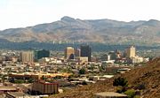
El Paso stands on the Rio Grande (Río Bravo del Norte), across the border from Ciudad Juárez. The image to the right, showing Downtown El Paso and Juárez, with the Juárez Mountains in the background, shows how the cities are conjoined. The two cities (Juárez was formerly El Paso del Norte, the Pass to the North) form a combined Metropolitan Area with a combined population of 2,049,648, with Juárez accounting for 2/3 of the Metro population.[7]
El Paso is home to the University of Texas at El Paso (founded in 1914 as The Texas State School of Mines and Metallurgy). Fort Bliss, a major United States Army installation, lies to the east and northeast of the city, extending north up to the White Sands Missile Range. The Franklin Mountains extend into El Paso from the north and nearly divide the city into two sections, with downtown connecting the two sections at the south end of the mountain range.
Contents |
History
Pre-Columbian era
Archeological evidence at the Keystone Wetlands and Hueco Tanks sites indicates thousands of years of human settlement within the El Paso region (see: Mogollon culture). A hueco is a Spanish term for a hollowed out cavity for holding water, or for pounding maize. The inhabitants during this era were maize farmers.[8] One of the two thousand images at Hueco Tanks is of a black and white figure of Tlaloc,[8] the Mesoamerican rain god; most of the images are of people and animals.[8] The Manso, Suma, and Jumano Indians were identified as present by the earliest Spanish explorers. These people ultimately became assimilated into the local settler population, becoming part of the Mestizo culture that is prevalent in Mexico and is visible throughout the Southwest. Others integrated themselves with the different Mescalero Apache bands that for many years roamed the region.
Arrival of Spaniards

Spaniard Don Juan de Oñate was the first European explorer to arrive at the Rio Grande near El Paso, and ordered his expedition party to rest and conducted a mass in celebration of thanksgiving on April 30, 1598.
El Paso del Norte (the present day Ciudad Juárez), was founded on the south bank of the Río Bravo del Norte, (Rio Grande) in 1659 by Spanish conquistadors. Being a grassland then, agriculture flourished and vineyards and fruits constituted the bulk of the regional production. The Spanish Crown and the local authorities of El Paso del Norte had made several land concessions to bring agricultural production to the northern bank of the river in present day El Paso. However, the Apaches dissuaded production and settlers to cross the river. The water provided a natural defense against them.
In 1680, after the successful Pueblo Revolt that decimated the Spanish colonies in northern New Mexico, El Paso became the base for Spanish governance of the territory of New Mexico. From El Paso, the Spaniards led by Diego de Vargas, grouped once again to recolonize the precious Spanish territory that was centered in Santa Fe and stretched from Socorro (New Mexico) to the areas that included Taos.
Historical records indicated that the first agricultural enterprise in the area was Ponce de León Ranch, on land granted in 1825.
Texas independence
El Paso was the southernmost locality of the Provincia de Nuevo Mexico (modern New Mexico). It communicated with Santa Fe and Mexico City by the Royal Road. Few foreign travelers, outside of Spanish merchants and officials, ventured that far north. It took six months for a trading caravan to reach Mexico City. Although American spies, traders and fur trappers had visited the area since 1804, notably Zebulon Pike, American settlers only began to stay for good, in significant numbers, after the Mexican-American War in 1849.[9]
Although there weren't any combats in the region during the Mexican Independence, Paso del Norte experienced the negative effects it had on the trade of its wines and produce that kept the town alive. It also experienced a major avulsion that left the towns of Ysleta, San Elizario and Socorro on the other side of the Rio Grande.[10]
In the first Mexican constitution (1824), given the dominance that chihuahuan merchants had on New Mexico, Paso del Norte went to the State of Chihuahua after being part of New Mexico for 200 years. The town elected its first local government in 1825 and opened the first official school in 1829.[11]
The Texas revolution (1836) was not felt in the region. The area was never considered part of Texas until 1848. The Battle of El Brazito near Las Cruces was fought by Missouri volunteers led by Col. Alexander William Doniphan, for whom Doniphan Drive was named, in El Paso. Given the blurry reclamations of the Texas Republic that wanted a chunk of the Santa Fe trade, the Treaty of Guadalupe Hidalgo effectively made the settlements on the north bank of the river a formal American settlement, separate from Old El Paso de Norte on the Mexican Side.[9]
The present Texas-New Mexico boundary placing El Paso on the Texas side was drawn in the Compromise of 1850.
A number of important developments during the 1850s shaped the character of the area north of the river. A settlement on Coons' Rancho called Franklin became the nucleus of El Paso, Texas. El Paso County was established in March 1850, with San Elizario as the first county seat. The United States Senate fixed a boundary between Texas and New Mexico at the thirty-second parallel, thus largely ignoring history and topography. A military post called The Post opposite El Paso (meaning opposite El Paso del Norte, across the Rio Grande) was established in 1854, and the Butterfield Overland Mail arrived in 1858. A year later pioneer Anson Mills completed his plat of the town, calling it El Paso, a name that resulted in endless confusion until the name of the town across the river, El Paso del Norte, was changed to Ciudad Juárez in 1888.[12]
El Paso was incorporated in 1873 and encompassed the small area communities that had developed along the river (Magoffinsville, Concordia, Hart's Mill).[13]
The Confederate States of America
During the Civil War, Texas, along with most other Southern states, seceded from the Union to join the Confederate States of America. The Confederate cause was met with great support from El Paso residents. Confederate forces occupied Fort Bliss in 1861, retaken by Union forces in August, 1862.[12] After the war was concluded, the town's population began to grow.
County seat at Tigua land in Ysleta
The Tigua Indians had occupied at least 36 sq mi (93 km2) of land around Ysleta, land that King Charles V of Spain had deeded to them, since the 1680 pueblo revolt against the Spaniards in New Mexico.[14][15] In 1874, the Texas Legislature passed "An Act to Repeal an Act to Incorporate the Town of Ysleta in El Paso County", with a six-month delay of effect that resulted in the conveyance of over 500 parcels of Tigua property to Americans. The Tiguas lost almost all of their land.[16]
The El Paso county seat was moved to Ysleta that year, from San Elizario, and stayed until it was moved to El Paso in 1883.[15] These were the years of the San Elizario Salt War and other conflicts between the Mexicans, the Americans, the Tigua, and the Apaches.
Real "Wild West"


With the arrival of the Southern Pacific, Texas and Pacific and the Atchison, Topeka and Santa Fe railroads in 1881, the population boomed to 10,000 by the 1890 census. With a tempting green valley and a nearly perfect climate year-around, the town attracted a constant stream of newcomers: gamblers, gunfighters, thieves, cattle and horse rustlers, murderers, priests, Chinese railroad laborers, prostitutes, and entrepreneurs.
After the arrival of the railroads, El Paso become a boomtown: it earned the nickname "Six Shooter Capital" because of its lawlessness, with "scores of saloons, dance halls, gambling establishments, and houses of prostitution lin[ing] the main streets."[12] El Paso hired a town marshal with rough reputation, Dallas Stoudenmire, who was known to shoot first and ask questions later. The "Four Dead in Five Seconds Gunfight" took place here on April 14, 1881. This was prior to the Gunfight at the OK Corral in Tombstone, Arizona. Stoudenmire, the sixth marshal in eight months, was hired to "clean" and tame a remote, violent and wild town. Stoudenmire was an effective marshal due to his fierce reputation and dexterity with his pistols. He effectively intimidated a violence-hardened town and used fear to control the City Council. On May 28, 1882, the City Council announced they were firing the marshal. Stoudenmire learned of this discussion, he entered the Council Chambers; they were terrified and remained quiet. Stoudenmire strolled up and down the chamber as he scolded, cussed profanities and threatened to shoot. In a blink of eyes, he pulled out and twirled his pistols as he growled, "I can straddle every God-damn aldermen on this council!" Council members quickly voted unanimously to retain Stoudenmire as their town marshal. Stoudenmire glared at them for a few seconds before he calmed down and put away his pistols. Knowing Stoudenmire's fearsome reputation, the Mayor defused a tense situation by calling for an abrupt adjournment. Stoudenmire exited the Chamber and a potential fatal incident was averted.
In 1883 the county seat was moved from Ysleta, Texas to El Paso. This was decided in a strongly disputed election in which counted votes were nearly three times the number of voters.
Prostitution and gambling flourished until World War I, when the Department of the Army pressured El Paso authorities to crack down on vice. Many of these activities continued in neighboring Ciudad Juárez, especially during the Prohibition, which benefited bars and saloons on the Mexican side of the border.

The Mexican revolution
The Mexican Revolution (1910-1920) began in 1910, and Ciudad Juárez was the focus of intense fighting. Occasionally, stray shots killed civilians on the El Paso side. El Paso became a center of intrigue as various exiled leaders including Victoriano Huerta and (for a time) Pancho Villa were seen in the city. In January 1914, General John Joseph Pershing was stationed at Fort Bliss, where he was responsible for security along the border and mounted the ill fated Pancho Villa Expedition against Pancho Villa after the infamous raid on Columbus, New Mexico on March 9 1916. The cavalry under Pershing were paid in gold, in competition with Pancho Villa, who offered $50 per machine gun. (When World War I began, Pershing's cavalry had to remain in the Army for the duration of the war, and were no longer paid in gold.) During this time period many rich people from Mexico fled to El Paso to escape Pancho Villa.
The roaring 20s to World War II
Beginning in the 1920s and into the 1930s, El Paso became the birthplace of several locally and nationally well-known businesses and events. In 1930, Conrad Hilton opened his first highrise hotel in El Paso, the now Plaza Hotel. The Plaza Theatre opened on September 12 1930.
In 1934, Walter Varney and Louis Mueller established the passenger airline called Varney Speed Lines in El Paso and operated out of the old El Paso Municipal Airport (1934–36) and then the El Paso International Airport. After the airline was taken over in 1937 by Robert Six, he relocated its headquarters to Denver, Colorado and renamed it with the more recognized name of Continental Airlines, as it is known to this day.[17] Although Continental Airlines would have its headquarters stationed in Denver, El Paso was still a major hub for the airline up until the late 1980s.
The college football Sun Bowl has been held in El Paso since 1936.
Post-war era

After World War II, Wernher von Braun and other German rocket scientists were brought to Fort Bliss in El Paso, along with many of the V2 rockets and rocket parts, starting the American rocket program; they were later moved to Huntsville, Alabama. One V2 rocket is still on display at Fort Bliss. The popular drink, the Margarita, was another famous invention given a home in El Paso. It was first mixed in the El Paso-Juárez area at Tommy's Place Bar on July 4, 1945 by Francisco "Pancho" Morales. Morales originally left bartending in Mexico to become a US citizen. He is listed in the Texas Almanac's Sesquicentennial Edition (1857-2007, under M) Obituaries of famous Texans. His story is best captured in a October 1973 Texas Monthly article "The Man Who Invented the Margarita" by Brad Cooper, and later in his obituary in the Washington Post on January 2,1997.
From World War II until the 1980s, El Paso boomed into a sprawling city. The expansion of Fort Bliss from a frontier post to a major Cold War military center brought in thousands of soldiers, dependents, and retirees. The industrial economy was dominated by copper smelting, oil refining, and the proliferation of low wage industries (particularly garment making), which drew thousands of Mexican immigrants. New housing subdivisions were built, expanding El Paso far to the west, northeast and east of its original core areas.
With the election of Raymond Telles,[18] the city's first Hispanic mayor in 1957, the demand for civil rights amongst the Hispanic population began. Stretching into the tumultuous 1960s, and converging with America's anti-war and civil rights demonstrations, great strides were achieved that became evident in the 1970s.
In 1963, the U.S. agreed to cede Chamizal, a long-disputed part of El Paso, to Mexico due to changes in the course of the Rio Grande, which forms the international boundary between the two countries. The area boundaries were rationalized and the Rio Grande was re-channelled. A former island in the river was re-developed. The Chamizal National Memorial, administered by the National Park Service is now a major park in El Paso; El Chamizal is the corresponding park in Juárez.
Since 1990, the local economy has been adversely affected by competition with low wage labor abroad, and the closure of the main copper smelter due to fluctuating metal prices, and excessive lead contamination found throughout many of the surrounding areas. The implementation of the North American Free Trade Agreement in 1994 affected the local economy, with transport, retail, and service firms expanding, and the accelerated loss of many industrial jobs. El Paso is sensitive to changes in the Mexican economy and the regulation of cross border traffic; the Mexican peso devaluation of late 1994 and increasingly stringent controls of cross border traffic after the September 11, 2001 Terrorist Attack were felt strongly in El Paso. (In contrast to almost every other border city and popular belief, the commercial traffic at the ports of entry went un-interrupted during the immediate aftermath of 9/11.)
Since the 1849 establishment of Fort Bliss in the El Paso area, El Paso has seen many booms in population. More recently, the BRAC commission has marked the base to receive more than 18,000 troops, which is estimated to add 547 million dollars to the El Paso economy. The expected 50,000 people destined for El Paso (18,000 troops & 30, 000 family members) will bring to El Paso a rise in population that has not been seen since the Mexican Exodus of the 1910s in which the town's population grew by at least 60,000 people that were trying to escape the carnage of the Mexican Revolution.
Recent city-wide projects funded through the election of bonds have once again pushed the urban sprawl onward for El Paso. The most prominent of these projects was the complete refurbishment of the Plaza Theatre in Downtown El Paso. The project was completed on March 17, 2006 at a cost of $38 Million. With the completion of a new freeway on the city's eastern edge, the city should experience the usual urban sprawl that accompanies such construction. With the arrival of military personnel and expansion of Biggs Army Airfield, the city is also constructing a new "Inner Loop" (Loop 375 to Fred Wilson Avenue) that will connect the eastern section of the city to the Army Airfield. Once completed, Biggs Army Airfield is expected to be larger than the current space at Fort Bliss.
Also of concern is how the large increases of population in Cd. Juárez will affect El Paso. Historically, these two towns have always been interconnected. Already evident is the air quality and traffic flowing inside the El Paso area, for these respective figures reflect the values of a metro area that is populated by at least two-million people. Many underestimate the area's infrastructure needs by allocating resource values for only the El Paso population and not the metropolitan population that is interconnected chiefly through the actions of commerce that stems from El Paso, Cd. Juárez, and the New Mexico cities of Las Cruces, Santa Teresa, Sunland Park and Alamogordo.
Geography


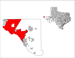
El Paso is located at (31.790208, -106.423242).[19] It lies at the intersection of three states (Texas, New Mexico, and Chihuahua) and two countries (the USA and Mexico). It is the only major Texas city on Mountain Time. When Ciudad Juárez was on Central Time[20], it was possible to celebrate New Year's twice in the same evening by travelling a very short distance across the state and into another country. Both cities are now on Mountain Time.
The city's elevation is 3,800 feet (1140 m) above sea level. The rustic North Franklin Peak towers at 7,192 feet (2,192 m) above sea level and is the highest peak in the city. The peak can be seen from 60 miles (97 km) in all directions. Additionally, this mountain range is home to the famous natural red-clay formation, the Thunderbird, from which the local Coronado High School gets its mascot's name. According to the United States Census Bureau, the city has a total area of 250.5 square miles (648.9 km²).
The 24,000-acre (97 km2) Franklin Mountains State Park is the largest urban park in the United States and resides entirely in El Paso, extending from the north and neatly dividing the city into several sections along with Fort Bliss and the El Paso International Airport.
The Rio Grande Rift, which passes around the southern end of the Franklin Mountains, is where the Rio Grande River flows. The river defines the border between El Paso from Ciudad Juárez to the south and west until the river turns north of the border with Mexico, separating El Paso from Doña Ana County, New Mexico. Mt. Cristo Rey, a volcanic peak (an example of a pluton) rises within the Rio Grande Rift just to the west of El Paso on the New Mexico side of the Rio Grande River. Other volcanic features include Kilbourne hole and Hunt's hole, which are Maar volcanic craters 30 miles (50 km) west of the Franklin Mountains.
El Paso is surrounded by the Chihuahuan Desert, the easternmost section of the Basin and Range Region.
Areas of El Paso
- Central El Paso
- East El Paso
- Mission Valley El Paso (Lower Valley and Ysleta, TX)
- Northwest El Paso (Commonly known as West El Paso; includes the Upper Valley)
- Northeast El Paso
With the city limits are traditional suburban areas that are located on the far eastern and western edges.
Texas suburbs outside the city
- Anthony
- Canutillo
- Clint
- Fabens
- Homestead Meadows
- Horizon City
- Montana Vista
- San Elizario
- Socorro
- Sparks
- Tornillo
- Vinton
- Westway
New Mexico suburbs
Although New Mexican areas of Anthony, Sunland Park, and Chaparral lie adjacent to El Paso County, they are considered to be part of the Las Cruces, New Mexico metropolitan area by the United States Census Bureau.[21]
- Anthony
- Sunland Park
- Chaparral
Climate

- El Paso has an arid, warm climate (Koppen climate classification BWh) with very hot summers (with little or no humidity) and mild, dry winters.
- Temperatures range from an average high of 55 F (13 °C) and an average low of 28 °F (−2 °C) in January to an average high of 97 °F (36 °C ) in June and an average low of 68 °F (20 °C) in August.
- The city's record high is 114 °F (45.5 °C), and its record low is −8 °F (−22 °C).
- The sun shines 302 days per year on average in El Paso, 83 percent of daylight hours, according to the El Paso Weather Bureau. It is from this that the city is nicknamed "The Sun City."[1] The natives find the weather attractive though temperatures can reach 100+ °F.
- Rainfall averages 8.74 inches (223 mm) per annum, most of which occurs during the summer from July through September and is predominantly caused by monsoonal flow from the Gulf of California. During this period, winds originate more from the south to southeast direction and carry moisture from the Pacific Ocean, the Gulf of California and the Gulf of Mexico into the region. As this moisture moves into the El Paso area (and many other areas in the southwest), a combination of orographic uplift from the mountains, and daytime heating from the sun, causes thunderstorms to develop across the region (some of which can be severe, producing flash flooding, hail and possible tornadoes). This is what causes most of the rain in the El Paso area.
- El Paso, at 3,800 feet (1,200 m) elevation, is also capable of snow; and has produced over a foot of snow on many occasions. In 1980, three major snowstorms produced over a foot of snow; one in February, another in April and the last one in December, producing a white Christmas for the city. A major snowstorm in December 1987 dumped nearly two feet of snow.
- Official weather records for El Paso have been kept by the National Weather Service since 1879.
Flooding
Although the average annual rainfall is only about 8 inches, many parts of El Paso are subject to occasional flooding during intense summer monsoons. In late July and early August 2006, over 15 inches (380 mm) of rain fell in a week, overflowing all the flood-control reservoirs and causing major flooding city-wide. The city staff has estimated damage to public infrastructure as $21 million, and to private property (residential & commercial) as $77 million.[22] Much of the damage was associated with development in recent decades in arroyos protected by flood-control dams and reservoirs, and the absence of any storm drain ultility in the city to handle the flow of rain water.
Maps
- El Paso, Texas is at coordinates
Temperature statistics
| Month | Jan | Feb | Mar | Apr | May | Jun | Jul | Aug | Sep | Oct | Nov | Dec | Year |
|---|---|---|---|---|---|---|---|---|---|---|---|---|---|
| Average high °F (°C) | 57 (14) |
63 (17) |
70 (21) |
79 (26) |
87 (31) |
96 (36) |
95 (35) |
93 (34) |
88 (31) |
79 (26) |
66 (19) |
58 (14) |
78 (26) |
| Average low °F (°C) | 31 (-1) |
35 (2) |
41 (5) |
49 (9) |
58 (14) |
66 (19) |
70 (21) |
68 (20) |
62 (17) |
50 (10) |
38 (3) |
32 (0) |
50 (10) |
| Precipitation inches (mm) | 0.4 (10.2) |
0.4 (10.2) |
0.3 (7.6) |
0.2 (5.1) |
0.3 (7.6) |
0.7 (17.8) |
1.6 (40.6) |
1.5 (38.1) |
1.4 (35.6) |
0.7 (17.8) |
0.3 (7.6) |
0.6 (15.2) |
8.6 (218.4) |
| Source: {{{source}}} {{{accessdate}}} | |||||||||||||

Architecture
10 Tallest Buildings in El Paso
| Rank | Name | Height | Floors |
|---|---|---|---|
| 1 | Wells Fargo Plaza | 296 feet (90 m) | 21 |
| 2 | Chase Tower | 250 feet (76 m) | 20 |
| 3 | Plaza Hotel | 239 feet (73 m) | 19 |
| 4 | Kayser Building | 232 feet (71 m) | 20 |
| 5 | El Paso Natural Gas Company Building | 208 feet (63 m) | 18 |
| 6 | Camino Real Hotel | 205 feet (62 m) | 17 |
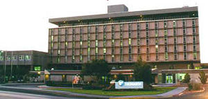
| 7 | Doubletree Hotel | 202 feet (62 m) | 17 |
| 8 | O. T. Bassett Tower | 196 feet (60 m) | 15 |
| 9 | El Paso County Courthouse | 185 feet (56 m) | 13 |
| 10 | Anson Mills Building | 145 feet (44 m) | 12 |
El Paso's tallest building, the Wells Fargo Plaza, was built in the early-1970s as State National Plaza. The black-windowed, 296-foot (90 m) building is famous for its 13 white horizonal lights that were lit at night. The tower did use a design of the United States flag during the 4th of July holidays as well as the American hostage crisis of 1980, and was lit continuously following the September 11, 2001 terrorist attacks until around 2006. During the Christmas holidays, a design of a Christmas tree was used, and at times, the letters "UTEP" was used to support UTEP athletics. The tower is no longer lit due to energy costs.
Politics
El Paso City and County vote overwhelmingly Democratic, like most of the Texas–Mexico border area and urban Texas.[23] The El Paso metropolitan area is represented by Silvestre Reyes (D-El Paso), chairman of the House Intelligence Committee, and Ciro Rodriguez (D-San Antonio) in the U.S. House; in the Texas State House by Democrats Paul Moreno, Chente Quintanilla, Norma Chavez, Joe Pickett and Republican Pat Haggerty; and in the State Senate, by Eliot Shapleigh (D-El Paso). In 2009, Democrat Marisa Marquez will replace Moreno, and Democrat Joe Moody will replace Haggerty.
Government
The current mayor of El Paso is John Cook, Democrat, who defeated Mayor Joe Wardy in the 2005 mayoral elections, and will run for re-election in May 2009.
The current members of the El Paso City Council, who are elected every four years to staggered terms, are Emma Acosta, Susie Byrd, Melina Castro, Steve Ortega, whose terms will end in 2009, and Eddie Holguin, Beto O'Rourke, Ann Lilly, and Rachel Quintana, whose terms will end in 2011. Lilly, Byrd, Castro, Ortega, Holguin, and O'Rourke have been on the council since 2005. Quintana has been on the council since 2007. Acosta has been on the council since 2008.
According to city charter amendments approved on February 7th, 2004, the city of El Paso operates under a council-manager form of government. This system combines the strong political leadership of elected officials, in the form of eight Council Members, with the strong managerial experience of an appointed local government manager. All power is concentrated in the elected council, which hires a professionally trained manager to carry out its directives and oversee the delivery of public services. Joyce Wilson was selected by the city council in 2004 as El Paso's first City Manager.
The El Paso County Judge is Anthony Cobos (Democrat), and the County Commissioners are Democrats Veronica Escobar, Luis Sarinana, and Miguel Teran, and Republican Dan Haggerty. Cobos and Escobar were first elected to their positions in 2006, and have been in office since 2007. Sarinana was defeated in the 2008 Democratic primary by Anna Perez. Teran did not run for re-election in the 2008 Democratic primary, which was won by Willie Gandara Jr. Haggerty has been a county commissioner since 1995.
Economy
El Paso is the Operational Headquarters of Helen of Troy Limited, a NASDAQ listed company that manufactures personal health care products under many labels such as OXO, Dr. Scholls, Vidal Sassoon, Sunbeam, among others. Also headquartered in El Paso is Western Refining, listed on the New York Stock Exchange.
El Paso is also the corporate headquarters to Spira Footwear, and the World Headquarters to the El Paso Saddle Blanket Co.
Until 1996, El Paso was home to El Paso Natural Gas Company. Now in Houston, Texas under the name El Paso Corporation. Farah Clothing Company was also headquartered in El Paso until 1998 when Farah along with other clothing manufacturing companies such as Levi's, moved their plants in search of cheaper labor. In the 1980s El Paso was known as the blue jeans capital of the world because it produced over 2 million pairs of jeans every week from different jean companies in El Paso. As of 2006, the only remaining companies in the clothing industry are Wrangler and a smaller company by the name of Border Apparel.
More than 70 Fortune 500 companies have offices in El Paso, including The Hoover Company, Eureka, Boeing, and Delphi (auto parts).
El Paso is an important entry point to the U.S. from Mexico. Once a major copper refining area, chief manufacturing industries in El Paso now include food production, clothing, construction materials, electronic and medical equipment, and plastics. Cotton, fruit, vegetables, livestock, and pecans are produced in the area. With El Paso's attractive climate and natural beauty, tourism has become a booming industry as well as trade with neighboring Ciudad Juárez.
Education is also a driving force in El Paso's economy. El Paso's three large school districts are among the largest employers in the area, employing more than 19,000 people between them. The University of Texas at El Paso (UTEP) has an annual budget of nearly $250 million and employs nearly 3,600 people. A 2002 study by the university's Institute for Policy and Economic Development stated that the University's impact on local businesses has resulted in $349 million.
The military installation of Fort Bliss is a major contributor to El Paso's economy. Fort Bliss began as a Cavalry post in 1848. Today, Fort Bliss is the site of the United States Army's Air Defense Center and produces approximately $80 million in products and services annually, with about $60 million of those products and services purchased locally. Fort Bliss' total economic impact on the area has been estimated at more than $1 billion, with 12,000 soldiers currently stationed at the Fort. A February 2005 article in the El Paso Times stated that as many as 20,000 troops could be arriving at Fort Bliss pending the Defense Department's removal of thousands of troops from overseas assignments. This would be in addition to 3,800 soldiers who would arrive as part of a new brigade combat team stationed at the Fort. The growth is expected to create a strong economic ripple throughout the El Paso area.
In addition to the military, the federal government has a strong presence in El Paso to manage its status and unique issues as a border region. The Immigration and Naturalization Service (INS), the Drug Enforcement Agency (DEA), and the U.S. Customs Service all have agency operations in El Paso to regulate traffic and goods through ports of entry from Mexico. Including these agencies, government job growth in the area is expected to rise to 64,390 jobs by 2007.
Call center operations make up 7 of the top 10 business employers in El Paso. With no signs of growth slowing in this industry, in 2005 the 14 largest call centers in El Paso employed more than 10,000 people. The largest of these in terms of employees are EchoStar, MCI/GC Services, and West Telemarketing.
Analysts in the area say that job growth in 2005 will be in the form of health care, business and trade services, international trade, and telecommunications.
Items and goods produced: petroleum, metals, medical devices, plastics, machinery, automotive parts, food, defense-related goods, tourism, boots
Largest city employers
- El Paso Independent School District 8,663
- Fort Bliss (civilian employees) 6,803
- Ysleta Independent School District 6,500
- City of El Paso 6,264
- University of Texas at El Paso 4,871
- Socorro Independent School District 3,995
- Sierra Providence Health Network 3,761
- El Paso Community College 3,728
- Wal-Mart 3,706
- El Paso County 2,700
- Las Palmas and Del Sol Regional Health Care System 2,244
- Echostar 2,012
All numbers are estimates as of 2006
Demographics
| Historical populations | |||
|---|---|---|---|
| Census | Pop. | %± | |
| 1890 | 10,000 |
|
|
| 1900 | 15,906 | 59.1% | |
| 1910 | 39,279 | 146.9% | |
| 1920 | 77,560 | 97.5% | |
| 1930 | 102,421 | 32.1% | |
| 1940 | 96,810 | −5.5% | |
| 1950 | 130,003 | 34.3% | |
| 1960 | 276,687 | 112.8% | |
| 1970 | 339,615 | 22.7% | |
| 1980 | 425,259 | 25.2% | |
| 1990 | 515,342 | 21.2% | |
| 2000 | 563,662 | 9.4% | |
| [24] | |||
As of the census[2] of 2000, there were 563,662 people, 182,063 households, and 141,098 families residing in the city. The population density was 2,263.0 people per square mile (873.7/km²). There were 193,663 housing units at an average density of 777.5/sq mi (300.2/km²). The racial makeup of the city was 76.6% White, 3.12% African American, 0.82% Native American, 1.12% Asian, 0.10% Pacific Islander, 18.15% from other races, and 3.40% from two or more races. Hispanic or Latino of any race were 86.62% of the population. The census states that about 7.6% of El Pasoans are non-Hispanic white.[25]
There are 182,063 households, out of which 42.4% have children under the age of 18 living with them, 54.6% were married couples living together, 18.5% had a female householder with no husband present, and 22.5% were non-families. 19.2% of all households were made up of individuals and 7.2% had someone living alone who was 65 years of age or older. The average household size was 3.07 and the average family size was 3.54.
In the city the population was spread out with 31.0% under the age of 18, 10.0% from 18 to 24, 29.1% from 25 to 44, 19.2% from 45 to 64, and 10.7% who were 65 years of age or older. The median age was 31 years. For every 100 females there were 90.4 males. For every 100 females age 18 and over, there were 85.0 males.
The median income for a household in the city was $32,124, and the median income for a family was $35,432. Males had a median income of $28,989 versus $21,540 for females. The per capita income for the city was $14,388. About 19.0% of families and 22.2% of the population were below the poverty line, including 29.8% of those under age 18 and 17.7% of those age 65 or over.
According to the 2006 United States Census Bureau population estimates, the El Paso metropolitan area had a population of 736,310.[6] Combined with the population of the neighboring Juárez metropolitan area, the total metropolitan area had a population of 2,280,782. As of December 3, 2007, El Paso is ranked the second safest city in the US with a population greater than 500,000.[26]
Sports
Major League teams
El Paso does not have a team in any of the big four professional leagues (NHL, NBA, NFL, MLB). El Paso hosts the annual NCAA Brut Sun Bowl, boxing matches, and occasional NBA preseason games and NFL exhibition games. El Paso is also the site of the Borderland Derby horse race held in the nearby suburb of Sunland Park. El Paso is also host of the Texas vs. The Nation Game all-star game played in the Sun Bowl Stadium.
Sports
| Club | Sport | League | Stadium |
|---|---|---|---|
| El Paso Diablos | Baseball | American Association of Independent Professional Baseball (South Division) | Cohen Stadium |
| El Paso Patriots | Soccer | USL Premier Development League | Patriot Stadium |
| Indios USA | Soccer | National Premier Soccer League | Canutillo Stadium |
| El Paso Rhinos | Hockey | Western States Hockey League (Jr. Hockey League) | El Paso County Coliseum |
| El Paso Brawlers | Football | Far West Football League | Sun Bowl Stadium |
| El Paso Generals | Indoor Football | IFL | El Paso County Coliseum |
| UTEP Miners | Division I | Conference USA | University of Texas at El Paso |
Arenas
- UTEP owns the two largest stadiums in El Paso:
- Sun Bowl Stadium has a capacity of 51,400 and is home to the UTEP Miners football team, coached by Mike Price. It is also home to the annual Brut Sun Bowl, soccer games, and special events such as concerts.
- Don Haskins Center has a capacity of 12,222 and is used for UTEP's basketball teams and special events such as concerts and boxing matches. It is also where the graduation ceremony takes place for UTEP students.

- The other major arena venues include:
- SISD Student Activities Complex (locally known as The SAC) has a capacity of 11,000 and is used for High School football, soccer, and track & field events for the high schools in the Socorro Independent School District.
- Jones Stadium El Paso High School has a capacity of 12000. It is the oldest stadium in El Paso having opened in 1916. Brigadier General Pershing used the new stadium during the pursuit of Pancho Villa. It was also the site of the first Sun Bowl played Jan. 1, 1935, pitting El Paso high school all-stars against the Ranger (Texas) High School Bulldogs.
- J. Quarles Thunderbird Stadium at Coronado High School is the highest stadium in elevation in the state of Texas.
- Canutillo Stadium has a capacity of around 12,000; it is used for high school football games and is home of the Indios USA soccer team.
- Cohen Stadium has a capacity of 9,725 and is used primarily for the El Paso Diablos Independent baseball club. It also hosts concerts and boxing matches and is able to host soccer games as well.
- El Paso County Coliseum has a capacity of 5,250. It is currently used primarily for special events such as concerts, wrestling matches, and others. It can also be utilized for hockey and arena football.
- Memorial Gym is a 5,000 seat multi-purpose arena located on the UTEP campus. It was home to the Miners basketball teams until the Don Haskins Center, then known as the Special Events Center, opened in 1976.
- Patriot Stadium has a capacity of around 3,000 and is solely used for the El Paso Patriots soccer club.
Education
Public school districtsThe city of El Paso is served by:
Nearby areas are served by:
Colleges and universitiesTwo-year and vocational colleges
Four-year colleges
|
Private and parochial schoolsThere are several parochial schools within the El Paso Catholic Diocese that include the following:
Other private schools include the following:
|
Ciudad Juárez residents attending schools in El Paso
Many Ciudad Juárez residents attend schools in El Paso, including El Paso ISD schools ("Mexican children cross border to go to school," Houston Chronicle, April 29, 2007). Due to the number of students from Ciudad Juárez enrolled in United States schools, the Paso Del Norte crossing (also called "Santa Fe bridge") holds a dedicated student crossing lane. The lane stays open from 6:30 A. M. to 8:30 A. M.
Hospitals
- Del Sol Medical Center[27]
- Las Palmas – Del Sol Rehab. Hospital
- Las Palmas Medical Center[28]
- Horizon Specialty Hospital
- Thomason Hospital-The city's general hospital and the only Level I trauma center in the area
- Rio Vista Rehab. Hospital
- Sierra Medical Center
- Southwestern General Hospital
- William Beaumont Army Medical Center
- Providence Memorial Hosptial
- Physicians Hospital
- Highlands Regional Rehabilitation Hospital
Culture
Literature

El Paso has been home to literary figures such as:
- Alicia Gaspar de Alba
- Frank Ambriz
- José Antonio Burciaga
- Mario T. Garcia
- Dagoberto Gilb
- Arturo Islas
- Tom Lea
- Cormac McCarthy
- Howard McCord
- Pat Mora
- John Rechy
The Tigua Indians of Ysleta del Sur Pueblo
Located within the city limits lies the autonomous Ysleta del Sur Pueblo Nation, with its own governing body. It is one of the three Federally-recognized Indian tribes in Texas.
The Tigua have been at their present location since a successful Pueblo Revolt of 1680 that forced the Spaniards and New Spaniards (future Mexicans) to retreat south to present day Ciudad Juárez, Chihuahua, and El Paso, Texas. The tribe is led by a governor who serves a term of two years. The current governor is Danny Senclare.
Very close to tribal lands is the sacred site of Hueco Tanks.
Points of interest

Area museums
- The Centennial Museum and Chihuahuan Desert Gardens
- The El Paso Holocaust Museum and Study Center
- The El Paso Museum of Archaeology at Wilderness Park
- The El Paso Museum of Art
- The El Paso Museum of History
- Fort Bliss Museums & Study Center
- Insights El Paso Science Museum
- Magoffin Home State Historic Site
- The National Border Patrol Museum
- Railroad & Transportation Museum of El Paso
- War Eagles Air Museum
- Gene Roddenberry Planetarium
Theaters
- The Abraham Chavez Theatre is located adjacent to the El Paso Convention & Performing Arts Center, welcomes patrons with a three-story-high glass-windowed entry and unique sombrero-shaped architecture making it a distinct feature on El Paso's southwestern landscape
- The Plaza Theatre is a historic building located at 125 Pioneer Plaza in El Paso, Texas. The theater stands as one of the city's most well-known landmarks. It shows various Broadway productions, musical concerts, and individual performers. It has a seating capacity of 2,100.
- McKelligon Canyon is a 90-acre (360,000 m2) park, located in the Franklin Mountains, open to hikers and picnickers. In the canyon, McKelligon Canyon Amphitheatre is surrounded on three sides by dramatic canyon walls; the 1,500-seat amphitheatre is used for concerts and special events, such as Viva El Paso!

Sites within the city limits
- Abraham Chavez Theatre
- Chamizal National Memorial
- The El Paso Zoo
- Fort Bliss
- Franklin Mountains State Park
- Cathedral Church of Saint Patrick
- Judson F. Williams Convention Center
- McKelligon Canyon
- Magoffin Homestead
- Plaza Hotel
- Plaza Theatre
- Union Depot
- University of Texas at El Paso
- Ysleta Mission
- The Tigua of Ysleta del Sur Pueblo Nation
Sites within the surrounding area
- Big Bend National Park
- Carlsbad Caverns National Park
- Guadalupe Mountains National Park
- Hueco Tanks State Park
- Lincoln National Forest
- Maar volcanic craters: Kilbourne Hole and Hunt's Hole
- The Mescalero Apache Nation
- Socorro Mission
- White Sands National Monument
Other sites of interest
- Williams Convention Center
- El Paso Zoo
- Western Playland
- Wet and Wild Water World
- Sunland Park Racetrack & Casino
Transportation
El Paso is served by El Paso International Airport, Amtrak via the historic Union Depot, Interstate 10, U.S. Highway 54 (known locally as "54," the "North-South Freeway" or officially as the Patriot Freeway), U.S. Highway 180 and U.S. Highway 62 (Montana Avenue), U.S. Highway 85 (Paisano Drive), Loop 375, Loop 478 (Copia Street-Pershing Drive-Dyer Street), numerous Farm to Market Roads (FM's) and the city's original thoroughfare, State Highway 20, known locally as Alameda Avenue (formerly U.S. Highway 80). The Northeast El Paso is connected to West El Paso by Transmountain Highway. The city also shares 3 international bridges and one railbridge with Ciudad Juarez, Mexico.
Airports
- El Paso International Airport
- Horizon Airport
- Santa Teresa Airport
Passenger rail
- The historic Union Depot with service provided by Amtrak.
Major highways
 Interstate 10 The primary thoroughfare through the city, connecting the city with other major U.S. cities such as Houston, Los Angeles, New Orleans, Phoenix and Dallas (via Interstate 20). The I-10 is also a connector to Interstate 25, which connects with the cities of Albuquerque, Denver and Cheyenne.
 U.S. Highway 54 Officially called the Patriot Freeway, locally known as the North-South Freeway. A business route runs along Dyer Street, the former US 54, from the freeway near Fort Bliss to the Texas-New Mexico border, where it again rejoins the expressway. The original U.S. 54 was a transcontinental route connecting El Paso with Chicago.
 U.S. Highway 62 mostly Paisano Drive, rerouted to Montana Avenue.
 U.S. Highway 85 Paisano Drive west of Santa Fe Ave to I-10.
 U.S. Highway 180 Montana Avenue, which is a bypass route to the Dallas-Fort Worth Metroplex to the east, and Flagstaff, Arizona to the west.
 SH 20 Alameda Avenue, formerly US 80.
 SH 178
 Loop 478 Copia Avenue to Dyer Street.
 Loop 375 Texas Highway Loop 375 encircles the city of El Paso. In the Northeast section of the city, it is Woodrow Bean Trans Mountain Drive. In East El Paso, the North- and Southbound section is known as Joe Battle Blvd., or simply as "the Loop". South of I-10, in the east and westbound portion, it is known as the Cesar Chavez Border Highway, a four-lane expressway which is located along the U.S.-Mexico border between Downtown El Paso and the Ysleta area.
Mass transit
- The Sun Metro Mass Transit system operates a system of medium to large capacity natural gas powered buses all around the city of El Paso.[29] Before 1987, Sun Metro was named Sun City Area Transit (SCAT).
- El Paso County Transit makes trips with small capacity buses mainly in the Eastern El Paso area.
International border crossings
The first bridge to cross the Rio Grande at El Paso del Norte was built in the time of Nueva España, over 250 years ago, from wood hauled in from Santa Fe.[30]
Media
Newspapers
- El Paso Times, English language news daily, founded in 1881.
- El Diario de El Paso, Spanish language news daily
- El Paso Inc.
- Newspaper Tree, an online newspaper that offers in-depth coverage of El Paso political and cultural events
El Paso had another English language daily newspaper, El Paso Herald-Post, but that newspaper ended publication in 1997.
Radio stations
|
|
El Paso also shares radio stations with nearby cities Las Cruces, New Mexico and Ciudad Juárez, Chihuahua.
Television
El Paso was the largest city in the United States without a PBS television station within the city limits until 1978. El Paso viewers had to watch channel 22, KRWG from Las Cruces until 1978. In fact, the city had only three English-speaking channels and two spanish language channels (channel 2 and channel 5) from Juarez, and cable subscribers in the 1970s and 1980s could receive four Los Angeles independent channels: KTLA, KHJ, KTTV and KCOP. Over time, as more television stations signed on and more cable channels were added (and the internet expanded), the L.A. stations would disappear from the lineup. The last to be removed was KTLA in the Fall of 2006, when KVIA-TV opened its own CW station.
El Paso's current television stations are as shown in the table below:
|
||||||||||||||
Popular culture
- "El Paso" by Marty Robbins was a popular Country ballad released in 1959.
- In the 1975 movie, The Stepford Wives the fluoride content in El Paso's drinking water is mentioned as a possible method the women of Stepford are being "brainwashed."
- In the movie Kill Bill the Massacre at Two Pines in which Beatrix Kiddo was put into a coma and her whole wedding party slaughtered took place in a small chapel just outside El Paso.
- The current Blue Beetle comic book series takes place in El Paso.
Filmed in El Paso
- The Burning Plain (2009) starring Charlize Theron. Scene shot on 2nd floor at Southwest General Hospital.
- No Country For Old Men (2007) starring Tommy Lee Jones and Javier Bardem. Destination El Paso, TX.
- Glory Road (2006) starring Josh Lucas.
- Beside You in Time (2006) Nine Inch Nails North American Tour 2006.
- Rx (2005) starring Colin Hanks, Eric Balfour and Alan Tudyk.
- Man on Fire (2004) starring Denzel Washington and Dakota Fanning.
- The Day After Tomorrow (2004) starring Dennis Quaid and Sela Ward.
- Saving Jessica Lynch (2003) starring Laura Regan.
- Kill Bill (2003) starring Uma Thurman.
- Kingpin (NBC pilot) (2003) starring Yancey Arias and Brian Benben.
- The Original Latin Kings of Comedy (2002) featuring George Lopez, Cheech Marin, Joey Medina, Alex Reymundo and Paul Rodriguez. It was shot at the Abraham Chavez Theater.
- Traffic (2000) starring Benicio del Toro, Michael Douglas, Catherine Zeta-Jones, Dennis Quaid and Don Cheadle.
- Committed (2000) starring Heather Graham.
- On the Border (1998) starring Casper Van Dien, Bryan Brown, Daniel Baldwin.
- Lolita (1997) starring Jeremy Irons and Melanie Griffith.
- Last Man Standing (1996) starring Bruce Willis, Bruce Dern, Christopher Walken, Karina Lombard.
- Courage Under Fire (1996) starring Denzel Washington and Meg Ryan had all the Persian Gulf War scenes shot at the Indian Cliffs Ranch.
- Blue Sky (1994) starring Jessica Lange and Tommy Lee Jones.
- Wild at Heart (1990) starring Nicolas Cage and Laura Dern.
- Extreme Prejudice (1987) starring Nick Nolte and Powers Boothe.
- Death of an Angel (1986) starring Bonnie Bedelia and Nick Mancuso.
- Lost in America (1985) starring Albert Brooks and Julie Hagerty.
- Fandango (1985) starring Kevin Costner and Judd Nelson. Wedding scenes were filmed in front of Mission San Elizario in San Elizario, Texas (near El Paso).
- Paris, Texas (1984) starring Harry Dean Stanton and Dean Stockwell.
- Lone Wolf McQuade (1983) starring Chuck Norris and David Carradine.
- Wrong is Right (1982) starring Sean Connery.
- The Border (1982) starring Jack Nicholson and Harvey Keitel. All the border scenes, the refugee camp scene, and the U.S. Embassy scene were all shot in and around El Paso.
- Second Hand Hearts (1981) starring Robert Blake and Barbara Harris.
- Resurrection (1980) starring Ellen Burstyn.
- When You Comin' Back, Red Ryder? (1979) starring Hal Linden and Lee Grant.
- Big Wednesday (1978) starring Jan Michael Vincent and Gary Busey.
- The Bad News Bears in Breaking Training (1977) starring William Devane.
- The Getaway (1972) starring Steve McQueen and Ali MacGraw.
- Manos: The Hands of Fate (1966) , which is reputed to be one of the worst films ever made, was shot in and around El Paso. It premiered in 1966 at the downtown Capri Theater.
- Take the High Ground! (1953), starring Richard Widmark and Karl Malden.
Sister cities
El Paso, Texas has two sister cities:
See also
- List of people from El Paso, Texas
Notes
- ↑ 1.0 1.1 Carlos A. Rincón (2002). "Solving Transboundary Air Quality Problems in the Paso Del Norte Region". in Linda Fernandez and Richard Carson. Both Sides of the Border. Springer. ISBN 1402071264. http://books.google.com/books?id=-80qhQ3mLDQC&pg=PA259&dq=%22el+paso%22+%22the+sun+city%22&as_brr=3&ei=tN4ySdq9GYbWlQS895i3DQ.
- ↑ 2.0 2.1 "American FactFinder". United States Census Bureau. Retrieved on 2008-01-31.
- ↑ "US Board on Geographic Names". United States Geological Survey (2007-10-25). Retrieved on 2008-01-31.
- ↑ Population Estimates for Places over 100,000: 2000 to 2006
- ↑ The fastest growing U.S. cities - Jun. 28, 2007
- ↑ 6.0 6.1 http://www.census.gov/population/www/estimates/metro_general/2006/CBSA-EST2006-01.csv
- ↑ El Paso Information and Links
- ↑ 8.0 8.1 8.2 Kevin Mulvihill (Friday, September 19, 2008), "On Rock Walls, Painted Prayers to Rain Gods", New York Times, pp. D1, D7. Mulvihill notes that the images are notable because they are painted with hematite, rather than pecked into the rock, as are the petroglyphs to be found in New Mexico.
- ↑ 9.0 9.1 El Paso, A Borderlands History, by W.H. Timmons, pp. 74, 75
- ↑ El Paso, A Borderlands History, by W.H. Timmons, pp. 106
- ↑ Chihuahua: Una Historia Compartida 1824-1821, by Guadalupe Villa and Graziella Altamirano, pp. 65-73
- ↑ 12.0 12.1 12.2 El Paso, Texas from the Handbook of Texas Online
- ↑ History Of El Paso
- ↑ Texas Highways, V.24, 1977
- ↑ 15.0 15.1 A. C. Greene (2006). 900 Miles on the Butterfield Trail. ISBN 1574412132. http://books.google.com/books?id=jAdYj0MqNNIC&pg=PA115&dq=county-seat+el-paso+ysleta+san-elizario&ei=h-eTR-3IJ4T0sQO5ia1J&sig=Og7ckQWCEx29esLzFiGRW0wOc3I.
- ↑ Leon C. Metz (1993), El Paso Chronicles, El Paso: Mangan Press.
- ↑ "Company History 1934 to 1958". About Continental.
- ↑ Mario T. Garcia (1998), The Making of a Mexican American Mayor: Raymond L. Telles of El Paso ISBN 0-87404-276-3
- ↑ "US Gazetteer files: 2000 and 1990". United States Census Bureau (2005-05-03). Retrieved on 2008-01-31.
- ↑ Time changes in Chihuahua[1]
- ↑ http://www.census.gov/population/estimates/metro-city/List4.txt
- ↑ www.elpasotexas.gov - City of El Paso
- ↑ William Earl Maxwell, Ernest Crain, Edwin S. Davis (2005). Texas Politics Today. Thomson Wadsworth. ISBN 0534602118.
- ↑ http://www.elpasotexas.gov/_documents/demographics/El%20Paso%20Ciudad%20Juarez%20Facts/Historical%20Population%20El%20Paso-Ciudad%20Juarez.pdf
- ↑ El Paso, Texas: ACS Demographic and Housing Estimates, 2006, from the U.S. Census Bureau
- ↑ San Jose now third safest city - News
- ↑ Del Sol Medical Center - Home Page
- ↑ Las Palmas Medical Center - Home Page
- ↑ www.elpasotexas.gov - Sun Metro Homepage
- ↑ Paul Horgan, Great River: The Rio Grande in North American History. Volume 1, Indians and Spain. Vol. 2, Mexico and the United States. 2 Vols. in 1, 1038 pages - Wesleyan University Press 1991, 4th Reprint, ISBN 0-8195-6251-3
External links
- City of El Paso Website
- Chamber of Commerce Website
- Forty years at El Paso, 1858-1898; recollections of war, politics, adventure, events, narratives, sketches, etc., by W. W. Mills, hosted by the Portal to Texas History
- El Paso Metropolitan Planning Organization
- El Paso Mortgage Company
- El Paso, Texas from the Handbook of Texas Online
|
|||||||||||||||||||||||
|

|
|||||||||||
|
|||||||||||||