East Sussex
| East Sussex | |
|---|---|
 |
|
| Geography | |
| Status | Ceremonial & (smaller) Non-metropolitan county |
| Origin | Historic |
| Region | South East England |
| Area - Total - Admin. council - Admin. area |
Ranked 33th 1,792 km² (692 sq mi) Ranked 30st 1,709 km² (660 sq mi) |
| Admin HQ | Lewes |
| ISO 3166-2 | GB-ESX |
| ONS code | 21 |
| NUTS 3 | UKJ22 |
| Demography | |
| Population - Total (2007 est.) - Density - Admin. council |
Ranked 28th 761,800 (ceremonial county) 424/km² (1,098/sq mi) Ranked 26th |
| Ethnicity | |
| Politics | |
 East Sussex County Council |
|
| Executive | Conservative |
| Members of Parliament | |
| Districts | |
|
|
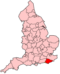
East Sussex (pronounced /ˈsʌsɨks/) is a county in South East England. It is bordered by the counties of Kent, Surrey, Brighton and Hove and West Sussex, and to the south by the English Channel.
Contents |
History
See main article:History of Sussex
East Sussex is part of the ancient kingdom of the South Saxons, who established themselves there in the 5th century AD, after the departure of the Romans, although the area had been populated for many thousands of years before then. Archaeological remains are plentiful, especially in the upland areas. The area's position on the coast has also meant that there were many invaders, including the Romans and later the Normans. Earlier industries have included fishing, iron-making, and the wool trade, all of which have declined, or lost completely. In more modern times, Sussex has become popular with tourists, so that the main coastal towns have become seaside resorts.
Governance
The ancient kingdom of Sussex has had two separate county administrations since the 12th century, with the county town of the eastern division being Lewes [1]. This situation was formalised by Parliament in 1865, and the two parts were given distinct elected county councils in 1889 under the Local Government Act 1888. In East Sussex there were also three self-administered county boroughs: Brighton, Eastbourne and Hastings.
In 1974 East Sussex was made a ceremonial county, and the three county boroughs became districts within the county. At the same time the western boundary was altered, so that the Mid Sussex region (including Burgess Hill and Haywards Heath) was transferred to the county of West Sussex. In 1997, Brighton and Hove became a self-administered unitary authority; it was granted city status in 2000, whilst remaining part of the ceremonial county of East Sussex.
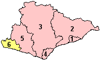
East Sussex is divided into five local government districts. Three are larger, rural, districts (from west to east) are: Wealden; Lewes; and Rother. Eastbourne and Hastings are mainly urban areas. The rural districts are further subdivided into civil parishes[2].
Geography
Geology
See map reproduced in Weald
From a geological point of view East Sussex is part of southern anticline of the Weald: the South Downs, a range of moderate chalk hills which run across the southern part of the county from west to east and mirrored in Kent by the North Downs. To the north lie parallel valleys and ridges, the highest of which is the Weald itself (the Hastings beds and Wealden Clay). The sandstones and clays come the sea at Hastings; the Downs at Beachy Head.
Relief and drainage
The relief of the county reflects the geology.
The chalk uplands of the South Downs occupies the coastal strip between Brighton and Eastbourne. There are two river gaps: the Rivers Ouse and Cuckmere. The Seven Sisters, where the Downs meet the sea, are the remnants of dry valleys cut into the chalk; they end at Beachy Head, 530 feet (162 m) above sea level. To the east of Beachy Head lie the marshlands of the Pevensey Levels, formerly flooded by the sea but now enclosed within a deposited beach. At Bexhill the land begins to rise again where the sands and clays of the Weald meet the sea; these culminate in the sandstone cliffs east of Hastings. Further east are the Pett Levels, more marshland, beyond which is the estuary of the River Rother. On the far side of the estuary are the dunes of Camber Sands. The highest point of the Downs within the county is Ditchling Beacon, at 814 feet (248 m): it is termed a Marilyn.
The Weald occupies the northern borderlands of the county. Between the Downs and Weald is a narrow stretch of lower lying land; many of the rivers and streams occupying this area originate in the Weald. The High Weald is heavily wooded in contrast to the South Downs; the Low Weald less so. Part of the Weald is the Ashdown Forest.

Settlements
The location of settlements in East Sussex has been determined both by its history and its geography. The original towns and villages tended to be where its economy lay: fishing along the coast and agriculture and iron mining on the Weald. Industry today tends to be geared towards tourism, and particularly along the coastal strip. Here towns such as Bexhill-on-Sea, Eastbourne, and Hastings lie. Newhaven and Rye are ports, although the latter is also of historical importance. Peacehaven and Seaford are more dormitory towns than anything else. Away from the coast lie former market towns such as Hailsham, Heathfield and Uckfield; Crowborough is a centre for the Ashdown Forest. Lewes, the County town of East Sussex; and Battle, with its Norman Conquest beginnings. are the other two towns of significance.
Economy
This is a chart of trend of regional gross value added of the non-metropolitan county of East Sussex (Brighton & Hove has a separate table) at current basic prices published (pp.240-253) by Office for National Statistics with figures in millions of British Pounds Sterling.
| Year | Regional Gross Value Added[3] | Agriculture[4] | Industry[5] | Services[6] |
|---|---|---|---|---|
| 1995 | 4,359 | 84 | 1,053 | 3,222 |
| 2000 | 4,953 | 54 | 1,155 | 3,744 |
| 2003 | 5,326 | 69 | 1,252 | 4,004 |
Landmarks
Apart from the physical landmarks such as the Downs and the Weald, East Sussex has a great many landmarks of historical interest. There are castles at Bodiam, Herstmonceux, Lewes and Pevensey; and defence works such as the Martello towers and Eastbourne Redoubt[7]. Battle Abbey, built to commemorate the Battle of Hastings; Bateman's, home of Rudyard Kipling, and the University of Sussex buildings at Falmer are among interesting buildings.
It also has a number of great parks suitable for tourists.
Transport
Roads

Unusually East Sussex has no motorways and only a few miles of dual carriageway. The main roads through the county are those part of the radial pattern from London: the A21 to Hastings; the A22 to Eastbourne; and the A23 to Brighton. Cross-country routes include the A26 which carries traffic from Newhaven and Lewes north into Kent; and the south coast trunk route, which starts in Folkestone (Kent) as the A259 trunk road, and traverses the south coast to Eastbourne, where it becomes the A27 trunk road and heads westwards towards Chichester in West Sussex and ultimately to Honiton in Devon. All the main roads suffer from congestion and traffic problems: the A27 which connects Eastbourne to Portsmouth is voted as one of the busiest trunk roads in the UK.
Bus routes serve all the main areas of settlement and many of the villages in the county.
Railways
The railways serve the main towns in a similar fashion to the roads. Until the closures of many branch railways in the 20th century, rural East Sussex was well-served by rail: few such branch lines escaped the Beeching Axe so that today only main-line services remain. They include the East Coastway Line (including the Marshlink Line); the London-Hastings line; and the Uckfield branch, the terminus of the Oxted Line. There are three heritage railways: the Kent and East Sussex Railway operates from Tenterden in Kent to Bodiam; the Bluebell Railway from Sheffield Park to Kingscote with a planned extension to East Grinstead; and the Lavender Line Steam Railway near Lewes.
Footpaths
see also Recreational walks in East Sussex
Among the long-distance footpaths in East Sussex are the South Downs Way; 1066 Country Walk, High Weald Landscape Trail, Saxon Shore Way, Sussex Border Path, Sussex Ouse Valley Way, Vanguard Way and the Wealdway.
Education
East Sussex has a comprehensive education system with 27 state secondary schools (not including sixth form colleges) and 12 independent secondary schools. Each of the larger towns also has a further education college. There are also a number of independent boarding schools in the county. The Pestalozzi Children's Village, an international foundation, is located at Sedlescombe.
See also
- ESCIS
- East Sussex travel guide from Wikitravel
References
- ↑ Census 2001 profile http://www.statistics.gov.uk/census2001/profiles/21-A.asp
- ↑ See List of civil parishes in East Sussex
- ↑ Components may not sum to totals due to rounding
- ↑ includes hunting and forestry
- ↑ includes energy and construction
- ↑ includes financial intermediation services indirectly measured
- ↑ Eastbourne Redoubt Fortress Military Museum Eastbourne Redoubt is the home of the Royal Sussex Regimental Museum
|
|||||
|
||||||||||||||||||||
|
|||||