East Riding of Yorkshire
 |
|
| Geography | |
| Status | Ceremonial county and (smaller) Unitary district |
|---|---|
| Origin | Historic division |
| Region | Yorkshire and the Humber |
| Area - Total - District - District area |
Ranked 23rd 2,479 km² Ranked 1st 2,409 km² |
| Admin. HQ | Beverley |
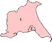
| ISO 3166-2 | GB-ERY (excludes Hull) |
| ONS code | 00FB |
| NUTS 3 | UKE11/12 |
| Demographics | |
| Population - Total (2007 est.) - Density - District - District. pop. |
Ranked 37th 590,000 138 / km² Ranked 10th 333,000 |
| Ethnicity | 98.3% White 1.1% S.Asian[1] |
| Politics | |
East Riding of Yorkshire Council http://www.eastriding.gov.uk/ |
|
| Leadership | Leader & Cabinet |
| Executive | Conservative |
| Members of Parliament | |
| Districts | |
|
|
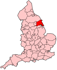
The East Riding of Yorkshire is a local government district with unitary authority status, and is a ceremonial county of England. It is named after the historic East Riding of Yorkshire (one of three ridings alongside the North Riding and West Riding), which also constituted a ceremonial and administrative county until 1974. From 1974 to 1996 the area of the modern East Riding of Yorkshire constituted the northern part of Humberside.
As a ceremonial county, it borders North Yorkshire, South Yorkshire and Lincolnshire, and includes the city of Kingston upon Hull, which is a separate unitary authority. As a district it borders North East Lincolnshire (over the Humber estuary), North Lincolnshire (over the Humber and on land), Hull, Doncaster, Selby, York, Ryedale and Scarborough.
By area, the East Riding is both the largest district and the largest unitary authority area in England. By population, it is the second largest non-metropolitan district (unitary or not) in England, after Bristol.[2]
Contents |
Geography
Geologically the East Riding is split into two parts. The western part is the Yorkshire Wolds, a chalk formation which extends from the Humber at Ferriby to the coast at Flamborough Head, a chalk headland. The south-east of the district is the low-lying coastal plain of Holderness, which faces east to the North Sea, and to the south drains into the Humber estuary. South of Flamborough Head is Bridlington Bay, which features a number of beaches, and at the far south-east of the district is the Spurn peninsula.
The coastline has retreated noticeably in the last 2,000 years with many former settlements now flooded, particularly Ravenser Odd and Ravenspurn, which was a major port until its destruction in the 14th century.[3] [4]
Erosion remains a concern in the area. Works on upgrading sea-defences started in Withernsea in 2005,[5] and village of Kilnsea is also to have defences upgrade.[6] Visitors have been warned by the Humber Coastguard to be very careful on coastal paths near Flamborough Head.[7]
The district is generally rural, with no towns approaching the size of Hull. There are a few market towns such as Beverley, Driffield, Goole, Market Weighton and Pocklington, and the coastal towns of Bridlington, Hornsea and Withernsea. In the south the district contains areas such as Hessle which are part of the Hull urban area but outside the city boundaries.
The East Riding district drains mostly into the Humber. The eponymous River Hull drains the area north of Kingston.
The district is entirely parished: Hull has no parishes. From 1996 Beverley had Charter Trustees to maintain the charter of the borough of Beverley: these were replaced by a Beverley Town Council in 1999, and Bridlington was parished in 1999. The unparished area consisting of the urban district of Haltemprice was divided into various parishes in 1999 and 2000.
See also: List of civil parishes in the East Riding of Yorkshire.
Demographics
According to the 2001 census, the district had a population of 314,113, and the most populous parishes are Bridlington (34,000), Goole (17,000), Beverley (17,000), Cottingham (17,000, part of the Hull urban area), Hessle (15,000, by Hull), Driffield (11,000), Anlaby with Anlaby Common (10,000, by Hull), Hornsea (8,000) and Willerby (8000, by Hull), Pocklington (8,000) and Elloughton-cum-Brough (7,000). Half the district's population reside in these 11 parishes, with the other half living in the other 160 parishes. In comparison, Hull's population according to the same census was 243,589. The population density of the district is around 135 people per square km, which makes it the least densely populated unitary authority after the Isles of Scilly, Rutland and Herefordshire.
The population of the East Riding is skewed to be older than average for England, with 18.4% of the people in the 2001 census being over 65 compared with 15.8% in England generally. There is a particularly strong deficit in the number of young adults.[8]
The district is one of the least ethnically diverse, with the census reporting 98.8% of the inhabitants being white. Hull itself is also quite monoethnic for a city of its size, with the census reporting 97.7% white.
History
The East Riding originated in antiquity. Unlike most counties in Great Britain, which were divided anciently into hundreds, Yorkshire was divided first into three ridings and then into numerous wapentakes within each riding. It should be noted that the ancient wapentake system is not used in the modern day, though it is an important part of its cultural heritige. Within the East Riding of Yorkshire there were twelve wapentakes (including Hull), this included;
|
1. Ouse and Derwent |
 |
7. Harthill Bainton Beacon |
The separate Lieutenancy for the riding was established after the Restoration, and the ridings each had separate Quarter Sessions.
For statistical purposes in the 19th century an East Riding of Yorkshire registration county was designated, consisting of the entirety of the poor law unions of Beverley, Bridlington, Driffield, Howden, Hull, Patrington, Pocklington, Sculcoates, Skirlaugh and York, thus excluding parts of the historic riding around Norton and Sherburn (which are also excluded from the modern district), but also including the city of York and environs (more usually associated with the West Riding). These poor law unions formed the basis of rural sanitary districts in 1875.

A county council for the East Riding of Yorkshire was set up in 1889, covering an administrative county which did not cover the county borough of Hull, but otherwise had the same boundaries as the historic riding. Apart from Hull the East Riding contained two municipal boroughs, Beverley and Hedon.
Under the Local Government Act 1894 the rest of the administrative county was divided into rural districts and urban districts. The rural districts were based on the rural sanitary districts, with Beverley Rural District, Bridlington Rural District, Driffield Rural District, Howden Rural District, Patrington Rural District, Pocklington Rural District, Riccal Rural District, Sculcoates Rural District and Skirlaugh Rural District being formed as-is.
Several other rural districts were formed by divisions of rural sanitary districts to conform to the administrative county borders : Sherburn Rural District and Norton Rural District came from Scarborough and Malton RSDs respectively (otherwise in North Riding); Riccal Rural District from Selby RSD (otherwise in the West Riding); and Escrick Rural District which was previously part of York RSD (which covered all three ridings). Urban districts were Cottingham, Great Driffield, Hessle (from 1899), Hornsea, Norton, Pocklington and Withernsea.
The East Riding's only large town is Hull, a major port. Hull's population of which rose rapidly in the late 19th century : quadrupling from about 60,000 in 1851 to 240,000 in 1901. Other towns in the riding did not have similar growth and remain small: Bridlington's permanent population remained largely static in the same period, increasing from 6,000 to around 7,000. By 1971 the riding had a population of slightly over 500,000. In comparison, the West Riding (including county boroughs) saw extensive urbanisation and the formation of several conurbations, and had a population of nearly 4,000,000 in 1971, and the North Riding a population of about 700,000. Beverley was once a town of some importance, with St. John's College and Beverley Minster. The college was suppressed along with the monastery in the 16th century (see Dissolution of the Monasteries) and the town entered a decline in relative importance, although gaining a charter of incorporation in 1573, having previously been under the Archbishop of York. Beverley benefited somewhat from the proximity of Hull during the Industrial Revolution, and became the county town for the East Riding administrative county in 1892.[9]

Bridlington obtained municipal borough status in 1899, having become a resort town (as had Hornsea and Withernsea), although not matching the population growth of Scarborough further up the coast in the North Riding.
The county districts underwent a major reorganisation in 1935 :
- Derwent Rural District formed from most of Esrick RD, Riccal RD and part of Howden RD (which continued in existence)
- Holderness Rural District formed from Patrington RD and Skirlaugh RD
- Sherburn RD abolished, split between Bridlington RD, Norton RD and part to Filey UD
- Sculcoates RD abolished, mostly to Beverley RD
- Great Driffield urban district made smaller and renamed Driffield, the rural part going to Nafferton parish in Driffield Rural District
- an urban district of Haltemprice formed to cover the urbanised area west of Hull, from Cottingham and Hessle urban districts, and parts of Sculcoates Rural District (including Haltemprice, West Ella and parts of other parishes)
- Pocklington urban district abolished and added to Pocklington RD
Both the administrative county and the historic Lieutenancy were abolished under the Local Government Act 1972, on 1 April 1974, with most of the riding going to form the northern part of Humberside. Some parts became part of North Yorkshire, with the borough of Scarborough taking in Filey UD and part of the Bridlington Rural District, the district of Ryedale taking in Norton and the former Norton Rural District, and the district of Selby taking in the former Derwent Rural District. Humberside also included northern Lincolnshire, and Goole and the former Goole Rural District, which are in the historic West Riding.
The creation of a cross-Humber authority was unpopular, despite the promise of the Humber Bridge (which ultimately opened in 1981), and identification with Yorkshire and the East Riding remained strong (for example, North Wolds District Council change its name to East Yorkshire District Council in the early 1980s, with Beverley also taking the name 'East Yorkshire Borough of Beverley'. This culminated with the local government review in the 1990s, which saw Humberside abolished and the northern part form two unitary authorities.
The East Riding district was formed on 1 April 1996 from the former districts of East Yorkshire, Beverley and Holderness, along with the northern part of the Boothferry district, including the Goole area which forms part of the historic West Riding (attaching it to the districts of Selby or Doncaster were proposed but rejected). The ceremonial county, the area in which the Lord Lieutenant of the East Riding of Yorkshire represents the Crown, was re-established the same day, covering Hull as well as the district.
Politics and government
The council elects on a four-yearly cycle with all seats up for election at the same time. It first had elections in 1995 - a year before it came into its powers - as a shadow authority. Between 1995 and 2007 the council was in not overall control, however in the 2007 local elections the Conservative Party gained a majority of seats, including those of the Liberal Democrat and Labour Party leaders'. The council has a leader-and-executive system, the leader being Stephen Parnaby of the Conservatives.
2007 local election results
| East Riding of Yorkshire Council Election Result 2007 | |||||||||
|---|---|---|---|---|---|---|---|---|---|
| Party | Seats | Gains | Losses | Net Gain/Loss | Seats % | Votes % | Votes | +/- | |
| Conservative | 47 | 18 | 0 | +18 | 69.1 | 46.7 | 111,272 | ||
| Liberal Democrat | 12 | 0 | 10 | -10 | 17.6 | 28.6 | 68,149 | ||
| Labour | 3 | 0 | 5 | -5 | 4.4 | 13.4 | 32,051 | ||
| Independent | 5 | 0 | 3 | -3 | 7.4 | 7.0 | 16,791 | ||
| Social Democrat | 1 | 0 | 1 | -1 | 1.5 | 1.5 | 3,453 | ||
| British National | 0 | 0 | 0 | 0 | 0 | 1.2 | 2,736 | ||
| Green | 0 | 0 | 0 | 0 | 0 | 0.8 | 1,821 | ||
| English Democrats | 0 | 0 | 0 | 0 | 0 | 0.5 | 1,156 | ||
East Riding of Yorkshire Council is based in Beverley, in the former headquarters of Humberside County Council, and East Riding County Council before that. In the Audit Commission report covering 2007 the council was given a four star rating which places the authority as one of the best in the country.[10][11]
Both the East Riding and Hull are still covered by the Humberside Police area and the Humberside Fire and Rescue Service.
For representation in the Parliament of the United Kingdom the bulk of the East Riding district is divided into three county constituencies: Beverley and Holderness, East Yorkshire and Haltemprice and Howden, which are all Conservative-held. One of Hull's three borough constituencies, Kingston upon Hull West and Hessle, spills into the area, as does Brigg and Goole, otherwise in North Lincolnshire. All the Hull seats are Labour-held, with Hull East being the seat of the former Deputy Prime Minister John Prescott.
Transport
The East Riding has only a small segment of motorway. Part of the M62 serves to link Hull area to West Yorkshire and the national motorway network, whilst the M18 incidentally passes the district border near Goole. Primary roads in the district include the A63, A164, A165, A1079, A166, and the A614.
Hull Paragon is a large railway station, served by lines to the west including London, (the Sheffield to Hull Line, running to Sheffield and Doncaster and the Hull to York Line, running to York and Selby), and to the north (the Yorkshire Coast Line, which serves Scarborough). See Railway stations in the East Riding of Yorkshire.
Train operators active in the area include Northern Rail, NXEC and TransPennine Express. Hull Trains are an 'open access' operator established in 2002 running frequent services to and from Kings Cross from Kingston upon Hull, Brough and Howden.
The Humber Bridge, a road-only bridge, and part of the A15, links Hessle, west of Hull, with Barton-upon-Humber in Lincolnshire. West of this the next crossing of the river (the Ouse at this point) are three bridges near Goole, a railway bridge, the M62 bridge and the A614. Humberside Airport, is located in Lincolnshire.
Economy
This is a chart of trend of regional gross value added of East Riding of Yorkshire at current basic prices with figures in millions of British Pounds Sterling.[12]
| Year | Regional Gross Value Added[a] | Agriculture[b] | Industry[c] | Services[d] |
|---|---|---|---|---|
| 1995 | 2,708 | 299 | 896 | 1,513 |
| 2000 | 3,006 | 209 | 1,090 | 1,707 |
| 2003 | 3,783 | 233 | 1,106 | 2,444 |
- a Components may not sum to totals due to rounding
- b includes hunting and forestry
- c includes energy and construction
- d includes financial intermediation services indirectly measured
Sport
Hull is the main centre for national-level sport in the region. Hull City A.F.C. earned promotion to the Premier League on May 24, 2008 with a victory over Bristol City. There are two rugby league teams based in the city: Hull FC and Hull Kingston Rovers both teams play in the Super League. There is also the Hull Stingrays ice hockey team who play in the highest tier of the sport, the Elite League.
Media
The region is covered by the BBC Yorkshire and Lincolnshire and ITV Yorkshire television regions. Local analogue radio stations include, BBC Radio Humberside, KCFM, Galaxy Yorkshire and Viking FM. A local Digital Audio Broadcasting multiplex is based around Humberside.
Community radio station Seaside FM serves the Holderness area on 105.3 FM MHz.
Newspapers include the Hull Daily Mail, owned by the Northcliffe Media group. An East Riding Mail has recently been launched as a sister paper to this. Other newspapers in the area include the Beverley Guardian, Holderness Gazette, the Bridlington Free Press, the Driffield Times, the "Driffield Post" and the Goole Times.
Towns and villages
- See also: List of civil parishes in the East Riding of Yorkshire

- Beverley, Bishop Burton, Bridlington, Brough
- Cottingham
- Driffield
- Flamborough
- Goole
- Hedon, Hessle, Holme-on-Spalding-Moor, Hornsea, Howden
- Kirk Ella
- Lockington
- Market Weighton
- North Ferriby
- Pocklington
- Riplingham, Roos, Rudston
- South Cave, Stamford Bridge
- Willerby, Withernsea
Places of interest
- ARTTS International
- Bempton Cliffs
- Burnby Hall
- Burton Agnes Manor House, Burton Agnes Hall
- Sewerby Hall
- Skipsea Castle
- Fort Paull
- Beverley Minster and Beverley Friary
- Howden Minster
- Skidby Working Windmill
- Hornsea Mere
- River Humber, River Hull, Watton Beck, River Derwent, River Ouse, River Aire, River Trent, River Don
- Rudston Monolith
- Aire and Calder Navigation
- Driffield Navigation
- Leven Canal
- Market Weighton Canal
- Pocklington Canal
- Stamford Bridge
- Yorkshire Wildlife Trust
- Yorkshire Wolds
- Flamborough Head
- Spurn
- Yorkshire Wolds Way, a long distance footpath
See also: List of SSSIs in Humberside.
Photos
References
- ↑ "Resident Population Estimates by Ethnic Group (Percentages); Mid-2005 Population Estimates". National Statistics Online. Office for National Statistics. Retrieved on 2008-03-28.
- ↑ "T 10: Mid-2004 to Mid-2005 population estimates; components of population change for local authorities in the United Kingdom; Mid-2005 Population Estimates". Office for National Statistics. Retrieved on 2008-02-05.
- ↑ "History of Ravenser Odd". YorkshireHistory.com. Retrieved on 2008-02-05.
- ↑ "WILGILSLAND - Kilnsea". Pete and Jan Crowther. Retrieved on 2008-02-05.
- ↑ "Rough seas delay defence project", BBC News Online, BBC (2005-01-10). Retrieved on 2008-02-05.
- ↑ "Flood defence for seaside village", BBC News Online, BBC (2006-06-25). Retrieved on 2008-02-05.
- ↑ "Walkers warned of coastal erosion", BBC News Online, BBC (2006-03-06). Retrieved on 2008-02-05.
- ↑ "Census 2001 - Population Pyramids - East Riding of Yorkshire (UA)". Office for National Statistics. Retrieved on 2008-02-05.
- ↑ "Victoria County History: A History of the County of York East Riding: Volume 6: The Borough and Liberties of Beverley". British History Online (1989). Retrieved on 2008-02-05.
- ↑ "East Riding a four star council". East Riding of Yorkshire Council (2008). Retrieved on 2008-02-09.
- ↑ ""Council Achieves Its Four-Star Goal"". This is Hull & East Riding (7 February 2008). Retrieved on 2008-02-07.
- ↑ "Regional Gross Value Added" (PDF) pp. 240–253. Office for National Statistics (2005-12-21). Retrieved on 2008-10-06.
External links
- Official Tourism information for East Yorkshire
- Bridlington Information
- East Riding of Yorkshire Council
- Many photographs of the East Riding of Yorkshire
- East Riding online
- Photographs of modern and historic features in the East Riding of Yorkshire
|
||||||||||||||||||||
|
|||||
|
|||||
|
|||||||||||||||||