Dnieper River
- For the rocket, see Dnepr rocket. For other uses, see Dnieper (disambiguation).
| Dnieper | |
|---|---|
| Russian: Днепр, Dnepr, Ukrainian: Дніпро, Dnipro, Belarusian: Дняпро, Dniapro
Pronunciation: \'nē-pər\ |
|
 |
|
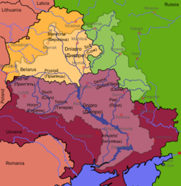
| Countries | Russia, Belarus, Ukraine |
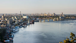
| Major cities | Dorogobuzh, Smolensk, Mahilyow, Kiev, Cherkasy, Dnipropetrovsk |
| Length | 2,290 km (1,423 mi) |
| Watershed | 516,300 km² (199,345 sq mi) |
| Discharge at | Kherson |
| - average | 1,670 m³/s (58,975 cu ft/s) |
| Source | Glaciers |
| - location | Valdai Hills, Russia |
| - coordinates | |
| - elevation | 220 m (722 ft) |
| Mouth | Dnieper Delta |
| - coordinates | |
| Major tributaries | |
| - left | Sozh, Desna, Trubizh, Supiy, Sula, Psel, Vorskla, Samara, Konka, Bilozerka |
| - right | Drut, Berezina, Prypiat, Teteriv, Irpin, Stuhna, Ros, Tiasmyn, Bazavluk, Inhulets |
 The Dnieper's drainage basin
|
|
The Dnieper River (Russian: Днепр, Dnepr; Belarusian: Дняпро, Dniapro, IPA: [dnʲa'pro]; Ukrainian: Днiпро, Dnipro), is a river that flows from Russia, through Belarus and Ukraine, to the Black Sea. Its total length is 2,285 km, of which 485 km lie within Russia, 595 km within Belarus, and 1,095 km within Ukraine. Its basin covers 504,000 km², of which 289,000 km² are within Ukraine.[1]
The Dnieper's source is the turf swamps of the Valdai Hills in central Russia, at an elevation of 220 m.[1] For 115 kilometres of its length, it serves as the border between Belarus and Ukraine. It is connected with the Western Bug by the Dnieper-Bug Canal. Its estuary, or liman, used to be defended by the strong fortress of Ochakiv.
Contents |
Geography
Tributaries of the Dnieper
The Dnieper has many tributaries. The main ones, in orographic sequence, are:
- Drut (R)
- Berezina (R)
- Sozh (L)
- Prypiat (R)
- Teteriv (R)
- Irpin (R)
- Desna (L)
- Stuhna (R)
- Trubizh (L)
- Ros (R)
- Tiasmyn (R)
- Supiy (L)
- Sula (L)
- Psyol (L)
- Vorskla (L)
- Samara (L)
- Konka (L)
- Bilozerka (L)
- Bazavluk (R)
- Inhulets (R)
Reservoirs
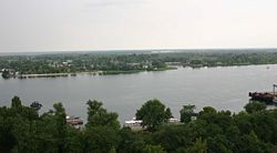
The Dnieper's last 800 kilometres before it flows into the Black Sea is an almost consecutive chain of reservoirs, all of them located in Ukraine. They were built along with the river's hydroelectric stations by the Soviet Union, and are used to generate hydroelectric power, providing around ten percent of Ukraine's electricity. The reservoirs include: Kiev (922 km²), Kaniv (675 km²), Kremenchuk (2,250 km²), Dniprodzerzhynsk (567 km²), Dnieper (420 km²), and Kakhovka (2,155 km²). The dams forming these reservoirs are used to generate hydroelectric power,
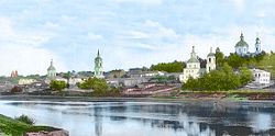
Cities and towns on the Dnieper

Cities and towns located on the Dnieper are listed from the river's source (in Russia) to its mouth (in Ukraine):
|
Arheimar, a capital of the Goths, was located on the Dnieper, according to the Hervarar saga.
The Dnieper is important for the transport and economy of Ukraine: its reservoirs have large ship locks, allowing vessels of up to 270×18 metres to access even the port of Kiev and thus create an important transport corridor. The river is used by passenger vessels too. Inland cruises on the rivers Danube and Dnieper have been a growing market in recent decades.
Upstream from Kiev, the Dnieper receives the water of the Pripyat river. This navigable river connects to the Dnieper-Bug canal, the link with the Western Bug river. Historically, a connection with the Western European waterways was possible, but a weir without a ship lock near the town of Brest has interrupted this international waterway. Poor political relations between Western Europe and Belarus mean there is little likelihood of re-opening this waterway in the near future.[2]
Navigation is interrupted each year by the winter freezing.
Economic significance
Hydroelectric power
The river is famous for its dams and hydroelectric stations. The most famous was the Dnieper Hydroelectric Station or (DnieproGES) near Zaporizhia, built in 1927-1932 with an output of 558 MW. It was destroyed during Second World War, and rebuilt in 1948 with an output of 750 MW. The others are: Kremenchuk (1954–60), Kiev (1960–64), Dniprodzerzhynsk (1956–64), Kaniv (1963–75).
Etymology
The name Dnieper (pronounced \'nē-pər\) is derived from Sarmatian Iranic Dānu apara "the river on the far side".[3] (By contrast, the Dniester derives from "the close river".)
In the three countries through which it flows it has essentially the same name, albeit pronounced differently, Russian: Днепр, Dnepr; Belarusian: Дняпро, Dniapro; Ukrainian: Дніпро, Dnipro.
The river is mentioned by the Ancient Greek historian Herodotus in the fifth century BC as Borysthenes (Βορυσθένης), as well as by Strabo; this name is Scythian (cf. Iranian *varu-stâna) and meant "wide land", referring most likely to the Ukrainian steppe. The late Greek and Roman authors called it Δαναπρις - Danapris and Danaper respectively,(Δανα in Old Persian means river); The name Dnieper probably derives from that Greek word. Its Old East Slavic name used at the time of Kievan Rus' was Slavutich "the Slavic (river)"; the Huns called it Var, and Bulgars - Buri-Chai.
In Popular Culture
- Folk metal band Turisas have a song called The Dnieper Rapids on their latest album The Varangian Way.
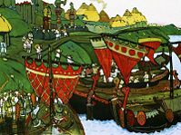
- It is one of the symbols of Ukrainian statehood and the Zaporizhian Cossaks.
- A few soccer teams are named after it as well as a few cities in Ukraine such as Dnipropetrovsk. Another city Zaporizhia is named after the region, meaning "beyond the Rapids".
- Trance artist Leon Bolier featured a track called Dnipro in his debut 2CD album Pictures. The track is said to be inspired by his visit to Kiev in May 2008.
See also
- Threat of the Dnieper reservoirs
- List of rivers of Russia
- List of rivers of Ukraine
- Trade route from the Varangians to the Greeks
References and footnotes
- ↑ 1.0 1.1 Kubiyovych, Volodymyr; Ivan Teslia. "Dnieper River". Encyclopedia of Ukraine. Retrieved on January 19, 2007.
- ↑ NoorderSoft Waterways Database
- ↑ Mallory, J.P. and Victor H. Mair. The Tarim Mummies: Ancient China and the Mystery of the Earliest Peoples from the West. London: Thames and Hudson, 2000. p. 106
External links
- Dnieper River at the Encyclopedia of Ukraine
- 1911 Encyclopædia Britannica — Dnieper
- Brockhaus and Efron Encyclopedic Dictionary — Dnepr
|
|||||||||||||||||