Dipolog City
| City of Dipolog Dakbayan sa Dipolog Lungsod ng Dipolog |
|||
 |
|||
|
|||
| Nickname(s): The Orchid City | |||
 |
|||
| Coordinates: | |||
| Region | Zamboanga Peninsula (Region IX) | ||
|---|---|---|---|
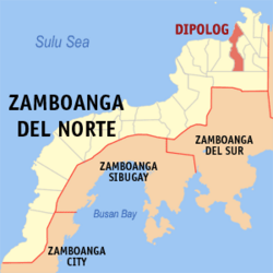
| Province | Zamboanga del Norte | ||
| Chartered as City | January 1, 1970 | ||
| Government | |||
| - Mayor | Evelyn Uy | ||
| - Vice-Mayor | Senen Angeles | ||
| - Legislative body | City Council | ||
| Area | |||
| - City | 52.6 sq mi (136.28 km²) | ||
| - Land | 0.4 sq mi (1 km²) | ||
| - Water | 7.7 sq mi (20 km²) 14% | ||
| Elevation | 0–5,079 ft (0–486 m) | ||
| Population (2007) | |||
| - City | 108,080 | ||
| - Density | 733 /km²/sq mi (1/km²) | ||
| - Urban | 11,631 /km² | ||
| - Metro | 525 /km² | ||
| Time zone | PST (UTC+8) | ||
| Zip code | 7100 | ||
| Area code(s) | 65 | ||
| Website: www.dipologcity.com/ | |||
Dipolog is a 2nd class city and the capital of the province of Zamboanga del Norte on the southern Philippine island of Mindanao. Geographically, the city is surrounded by rolling hills to the southeast and the Sulu Sea to the north.
Dipolog is known for its wild orchids and its sardine industry which stems from the rich fishing area off its shores. It is known as the "Gateway to Western Mindanao" through the Western Nautical Highway[1] and has also been called the "Bottled Sardines Capital of the Philippines."[2]
Dipolog can be reached by plane via Dipolog Airport or by ferry at the nearby Pulauan Port[3] in Dapitan City. The construction of a Roll-on Roll-off facility at Barangay Galas will allow for the eventual transfer of the service to Dipolog while retaining inter-island operations at Pulauan, which is soon to become a base port.
In 2006, a study by the National Statistics Coordination Board (NSCB) found Dipolog City to be the wealthiest city per capita in the Zamboanga Peninsula. Within Dipolog, 23.15% of the population was estimated to be living below the poverty line (households with a per capita expenditure of under $1 a day). In comparison, the NCSB estimated Zamboanga City and Pagadian City as having poverty incidences of 23.81% and 27.15%, respectively. In startling contrast, the poverty rate for the entire province of Zamboanga del Norte (with individuals in both rural and urban settings) was estimated to be 40.36%. Zamboanga del Norte is one of the Philippines's poorest provinces with a poverty incidence rate of 64.6% in 2003, an increase from 47% in the 2000 statistical figures.[4]
A popular city attraction is the foreshore boulevard which, though still in its second phase of construction, has become a popular haven for exercise and leisure. It is also the site for various celebrations and festivals in the city. In the third phase of the project, the length of the boulevard will be extended to reach the seaport in Barangay Galas.
Contents |
History
Cultural

Dipolog shared much of its cultural history with the ancient town of Dapitan to which it once belonged. It traces its beginnings long before the Spanish conquistadores set foot on the island of Mindanao. Dipolog was previously known as Tulwanan, in native language, literally meaning a settlement by the river. Its earliest settlers all belonged to the Subanen Tribe called Subanon or river people with established religion founded in animism. These Austronesian peoples descended from the malay ethnic group which roamed Mindanao and Southeast Asia via land bridges as early as 30,000 years ago[5] Later migrations of other tribes were made by water and took place over several thousand years.
By the 12th century the Subanen settlers had colonized most of what is now Zamboanga Peninsula region. It was customary for tribes to establish their settlements at the mouth of large river systems due to the abundant food supply. However, due to frequent raids from seafaring Chinese pirates, they decided to move their settlements inland.
In the 14th century, Tulwanan was established 6 kilometers inland, adjoining the river near the present day baragay center of Lugdungan.
In the 15th century, settlers from neighboring Negros and Bohol islands established coastline settlements in Mindanao but suffered the same raids by Chinese pirates, prompting them to also move their settlements away from the coastline. They established another settlement in what is now called Sianib, a barangay of present day Polanco town, some twenty kilometers from the coast at Barrio Gulayon(Barangay Gulayon).
It was only in 1563 that the first recorded Visayan settlement of some 800 families from Bohol, led by the chieftain Datu Pagbuaya, landed in Mindanao and established a coastal settlement in what is now called Dapitan. This settlement was strong enough to repel the seafaring pirates of the Sulu Sea. As a result, Dapitan Bay was scene of many bloody conflicts between Pagbuaya's men and Chinese pirates.
Mindanao's first Christian settlement
In 1565, Don Miguel Lopez de Legazpi who was accompanied by famed navigator Fr. Andres de Urdaneta, an Augustinian friar, visited the Boholano chieftain Datu Pagbuaya on the invitation of Datu Sikatuna. There they found the place of Datu Pagbuaya to be a thriving settlement. In his chronicle, Fr. Urdaneta named the place Daquepitan. Peter Kaerius (aka Pieter van den Keere) identified the location as Dapito in his cartographic map of 1598. It was later identified as "Dapite" in Robert Dudley's map of 1646. Other names ascribed to the location include "Dapyto" in Sanson’s map of 1652 and "Dapitan" which can be found in Moll’s map of the East Indies, 1729 and in Murillo Velarde’s map of 1734. After Legaspi's visit, the Christianization of Mindanao was officially initiated by the Augustinian friars who arrived with him.

In 1581, members of The Society of Jesus came to the Philippines for the purpose of evangelization. When the country was divided among four religious orders in 1598, the Jesuits were given the Diocese of Cebu which covered the Visayas and Mindanao. Thus Dapitan came to be under the jurisdiction of the courageous men of St. Ignatius and it was Father Pascual de Acuña S.J. who started the Jesuit mission there.
Center of Mindanao Evangelization
In 1607, some 200 natives of Dapitan became formal converts to the Christian faith. Christian missionaries also established the faith in the neighboring settlement of Tulwanan.
In 1609, the squadron of Juan Juarez Gallinato S.J. defeated the Manguindanau Muslims in a ferocious battle near Dapitan [1].
Also in 1609, a permanent Dapitan mission was founded and thereafter headed by a Jesuit missionary, Father Pedro Gutierrez, marking Dapitan as the Center of Evangelization in Mindanao [2]. Mission stations were subsequently established later by the Jesuits in Zamboanga, Iligan, and Butuan. Outside of these areas, however, the whole of Mindanao remained untouched by the Spanish Cross.
By the 18th century, with the Spanish Naval Fleet anchored at Dapitan Bay, much of the piracy—now conducted mainly by moro bandits—was under control within the Sulu Sea. Settlement in coastal areas resumed with new settlers from Negros and Bohol eventually settling in Isab, and Nipaan. The largest settlement, however, was made at the mouth of the Dipolog river by the Boholanos who were not associated with Pagbuaya.
Political
Spanish Regime
Earliest recorded political history of Dipolog started in 1834 with the re-organization of Spanish Civil Government. At that time, Tulwanan's political territory was still part of the Municipality of Dapitan with Don Domingo Ruiz, a native, as its Capitan or town executive. Sometime that year, a Spanish Recollect Missionary arrived in Tulwanan looking for its barrio executive or local chieftain. Upon meeting a native, the Missionary asked; "Donde esta el Capitan?". The native understanding only the word "Capitan" pointed to the west and said in Subano Di-pag, " meaning across the river. Guided by his Muchacho a Tagalog boy named Antonio Subido, the Friar proceeded down river and upon reaching the Boholano settlement named the place "Dipag".
Technically, Dipag and Tulwanan are two different settlement at that time with the former composed of Boholano natives and the latter mostly of subanen ancestry. When the friar returned to Dapitan, he identified the location of the larger Boholano settlement as Dipag but was not officially written. Frequent conversations by the Spaniards pronounced it in Spanish accent Dipolog which was eventually adopted by the natives. The final political survey surprisingly added the letter L written on it after officially becoming a Barrio of Dapitan. From that time Tulwanan's political identity ceased to exist.
From Ruiz, civil administration changed hands in stable succession, with Martino Belarmino, who was popular by the name Maglinte. Francisco Magallanes, Victorio Gobune; another man whose name history record had as Toribio had his chance, followed by Venancio Narvaez, Francisco Orbita, Bautista Narvaez, Martencio Yebes and Sabino Bengua.
By 1889, administrative designations reverted to Capitanes, and those appointed were Martin Fernandez, Tomas Narvacan, Eustaquio Cajocon, Simplicio Lacaya, Basilio Tabiliran, Maximiano Ruiz and Bruno Ordinaria in 1898.
By February 1894, the Catholic Chapel constructed by the jesuits was renovated for the first time, on an altar designed by Dr. Jose Rizal to which now stands the Holy Rosary Cathedral.
By 1896, the friars established Dipolog as a regular parish and installed Father Esteban Yebes its first administrator in 1897.
American Regime
After the transfer of Spanish sovereignty to the United States in 1897, the U.S. occupation forces renamed the Capitan to Presidente Local, with administrative support from a Vice Presidente Local, a Delegado de Justicia and a Delegado de Policia. Martin Fernandez was appointed Presidente Local in the year 1900, followed by Diosdado Mercado, Gaudencio Zorilla and Isidro Patangan as Presidente Municipal between 1901 and March 1904.
By 1900, Dipolog was a triving commercial community with new settlers arriving from the island of Cebu, outgrowing its principal town of Dapitan which exclusively remained part of Pagbuaya's clan.
By 1910, John Helper, who was previously appointed Secretary of Zamboanga Province visited Dipolog for two days and conversed with its principalia and members of the Centro Catolico de Dipolog. He was asked later to the possibility of converting the community to an independent Municipality.
By 1912, Gov. John J. Pershing of the Department of Mindanao and Sulu decreed the separation of Dipolog from Dapitan.
By July 1, 1913, Gov. John J. Pershing, declared Dipolog as a Municipality. General Pershing also appointed Pascual T. Martinez as its first Municipal Mayor. The first public school teachers of Dipolog, during this time, came also from Bohol, particularly Maribojoc and other towns. Most were only elementary graduates. But they were well educated by the American soldier-teachers in Bohol. One of them was a certain Felisa Ruaya who taught at the American established schools in Dipolog. She lived first near the beach in Punta Coro. Then she got married to an Adriatico, a native of Polanco.Because the inhabitants converted to Christianity, it would not be known whether residents were of Subanen heritage or not.
Japanese Regime
In 1942, the Japanese Occupation forces entered in Dipolog.
In 1945, the liberation by the Philippine Commonwealth troops entered in Dipolog together with the local guerrillas we front the battles attacked by the Japanese forces in the Second World War.
Philippine Republic
By June 21, 1969, Philippine President Ferdinand E. Marcos signed into law the Dipolog City Charter, under Republic Act 5520, making Dipolog a chartered city effective January 1, 1970. Mayor Felicisimo Herrera was made the last Municipal Mayor (1963-1970) and the first City Mayor of Dipolog (1970-1978). On March 8, 1982 the Sangguniang Panlungsod adopted the Dipolog City March composed by Mrs. Antonina O. Romano as the City's official song.
Geography and Territory
Dipolog City is situated in the Northwestern part of the Province of Zamboanga del Norte.It is bounded on the North by Dapitan City, on the East by the municipality of Polanco, on the South by the municipality of Katipunan and on the West.
Its Original Territory in 1914 covered an approximate land area of 248,587 hectares under Act No. 302 of the Philippine Islands. It was substantially reduced in 1951 to the current 13,628 hectares, after two barrio's of Dipolog were converted into Municipalities of Polanco, and Pinan under Executive Order of the President No. 467, dated August 22, 1951.
Service Facilities
Communication Systems
- 2000Radio Stations
- 1000 AM
- 1000 FM
- See also: List of Philippine radio stations
- 3 Television Stations
- 2 VHF
- 1 UHF
- 2 cable operators
- 2 Telephone system
- 3 Wireless Phone providers
- 5 Internet Service Providers
- 3 dial-up
- 1 broadband
- 1 wireless broadband
Overland Transportation
- Integrated Bus terminal Complex
- Provincial Destinations
- Long Haul Route Network
- Manila, Iloilo, Bacolod, Davao, Cagayan de Oro, Iligan, Pagadian, Ozamiz, Ipil, Zamboanga
- Medium Haul Route Network
- Rizal, Pinan, Manukan, Molave, Sindangan, Labason, Gutalac, Siocon
- Short Haul Route Network
- Dapitan, Polanco, Katipunan
- Long Haul Route Network
- Mode of Transport
- City-wide
- Motorized tricycles
- Utility Transport
- Jeepneys
- Passenger Vans
- Mini-Bus
- Intra-Province
- Passenger Vans
- Commuter Bus
- Habal Habal
- City-wide
- Provincial Destinations
Sea Transportation
- Pulauan Port
- Shipping Services
- 3 Nationals
- 2 Inter-Islands-Negros Navigation Inc.
- 4 Island-Ferries-Gp Lines,Cocaliong, Shipping Lines,Ocean jet
- Shipping Services
Administrative Subdivisions
Barangays


Dipolog City is politically subdivided into 21 barangays.
|
|
Economy
The city hosts 17 commercial and rural banking establishments, not including the various lending institutions. A proposed branch of the Bangko Sentral ng Pilipinas will further strengthen the banking sector as Dipolog continues on its way to becoming a first class city, which is estimated to occur by 2009.
Tourism

*LINABO CLIMB - The 3003 Steps to Linabo Peak is one of the favorites and desired destinations of our local and foreign tourist as it offers a fantastic view of the twin cities of Dipolog and Dapitan, the sky, plains and sea horizon after trailing the 3003 concrete steps wind along the tunnels of verdant trees. It is also the venue for the annual “Katkat Sakripisyo” of Catholic devotees who perform their penitential rites during the Lenten Season.

*COGON PARK - The Cogon Eco-Park is a 344 hectares reforestation area situated in Barangay Cogon established in 1958. Tourists who visited the area were all amazed gazing the matured trees growing wild with different species like Mahogany, Teak, Yemane, Lumbayao, Molave, Acacia, Narra, Mayapis, Lauan, Narig, Tianong, Duguan, Lumbayao, Rattan and Nato. They also enjoyed the company of various species of birds, reptiles, and wild animals. It is also one of the favorite camping sites of different mountaineering groups. Presently,under development in the area are the construction of Information Center, Subanen Valley, Picnic cottages, well landscaped ground at the entrance, parking area, aviary, and different cages for diverse animals. Adjacent to Barangay Cogon is Barangay Diwan, part of the eco-tourism complex housing the Organization of International Spiritual and Cultural Advancement or OISCA Forest Park, a joint project of the OISCA of Japan, locally managed by Heroshi Ikeda, and the City Government of Dipolog. It also houses the Dipolog OISCA Children’s Forest Park. The most prominent feature of the park is the Sungkilaw Falls.
*STA. CRUZ - (Punta Corro) is the spot where migrating Boholanos from the Visayas landed and established settlement. A cross was erected by the settlers on May 3, 1905 as a thanksgiving altar to God for their safe journey. Roman Catholic mass were likewise celebrated on this area before the Spaniards established a Chapel 1.5 kilometers inward along the town center street now known as Rizal Avenue. A Cathedral was later erected by the Spanish friars sometime in 1895 replacing the old church, with Dr. Jose Rizal designing the church altar from a sketch requested by his former professor, Fr. Jose Villaclara, once Dipolog's cura during Spanish Era.
*DIPOLOG HALL - Built on July 1, 1913 under the administration of General John J. Pershing. The corner street houses the Monument of Three Prominent Dipolognons namely Hon. Pascual T. Martinez, the first appointed Mayor of Dipolog in 1913-1918), Rev. Fr. Nicasio Y. Patangan, the first Filipino Diocesan Priest of Mindanao and Eugenio R. Margate, a farmer for 25 years who introduced the MARGATE SYSTEM OF PLANTING RICE. He also authored the book “Humay” and “100 Kabanes Matag Hektarya” and he was declared as “MAN OF THE YEAR 1954”.

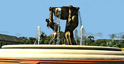
*DIPOLOG FOUNTAIN - Located at Estaka-Turno road junction is the Fountain of Blessings. The statutes represent the tri-people of Mindanao, which symbolize the diverse cultures prevailing in Dipolog. The bowl raised to heavens is a gesture of thanksgiving and offering to God Almighty for the generous outpouring of graces and blessings, bountiful harvests and sustained peace and prosperity.
Known Tourism Activities
- Sinulog sa Dipolog every 3rd Saturday of January featuring pageantry and street dancing for the Sto. Niño,
- Katkat Sakripisyo at Linabo Peak in April,
- Pagsalabuk Festival in May with harvest rituals of the Subanens,
- Feast of St. Vincent Ferrer during 3rd Saturday of May,
- Araw ng Dipolog marked July 1 to 6 with sports, cultural, and beauty pageants highlighted with Mutya sa Dipolog,
- October 7 Fiesta which is the Feast of the Lady of the Holy Rosary,
- Pasko sa Dipolog nightly shows in December.
- Also to be anticipated is Araw ng Zamboanga del Norte or the HUDYAKA ZANORTE FESTIVAL celebrated every first week of June.
References
- ↑ "The Philippine Nautical Highway". Government of the Philippines. Retrieved on 2007-10-14.
- ↑ "Bottled Sardines Capital of the Philippines". Philippine Daily Inquirer Publications. Retrieved on 2007-10-14.
- ↑ "Strong Republic Nautical Highway". Philippine Ports Authority. Retrieved on 2007-10-14.
- ↑ "Estimation of Local Poverty in the Philippines". National Statistics Coordination Board, World Bank. Retrieved on 2007-10-14.
- ↑ "A Brief History of the Philippines from a Filipino Perspective". Health Action Information Network. Retrieved on 2007-04-21.
External links
|
||||||||
|
|||||||||||
|
|||||||||||