Detroit River
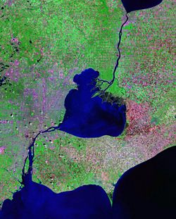
The Detroit River is a river in the Great Lakes system, about 32 miles (51 km) long and 0.5 to 2.5 miles (1–4 km) wide. The name comes from French Rivière du Détroit, i.e. "River of the Strait". The name is a reference to the fact that the river connects Lake St. Clair to Lake Erie. However, it is not a strait by definition, since those lakes are at different elevations. The boundary between Canada and the United States of America passes through the river lengthwise, dividing the cities of Detroit, Michigan and Windsor, Ontario. Its elevation is 579 feet (175 m) above sea level.
Contents |
Geography
Tributaries
While primarily a lake outlet, the Detroit River does have a few tributaries of its own which drain 2,000 square kilometers (772 sq mi). These include the Rouge River, Ecorse River, Conner Creek and Marsh Creek in the United States, and Turkey Creek, Little River and River Canard in Canada.
Islands
Islands in the Detroit River include Peche Island, Belle Isle, Zug Island, Fighting Island, Turkey Island, Grassy Island, Grosse Ile, and Bois Blanc (also known as Boblo) Island. The islands of the lower Detroit River are part of the Detroit River International Wildlife Refuge which is the only international wildlife preserve in North America. The Refuge includes islands, coastal wetlands, marshes, shoals, and waterfront lands along 48 miles (77 km) of the Detroit River and Western Lake Erie shoreline.
Elevation
The river drops three feet from 574 ft. at Lake St. Clair to 571 ft. at Lake Erie.
History
Historical events concerning the Detroit River began with the arrival of the French voyageurs, the first non-natives to navigate the river and land on Detroit's shores. Canoes made of birch or elm bark were a common mode of travel across the river, although the pirogue and bateaux were also used.
The War of 1812 was partially fought along the Detroit River front, and by 1850, the census showed 21,019 people populated Detroit. Ferries, schooners and steamboats were found traveling along the river.
During the Civil War, the river was patrolled in case of a Confederate attack from the Canadian north.
As commerce grew, Detroit was becoming the busiest port in the world, and was dubbed "the Greatest Commercial Artery on Earth." 67,292,504 tonnage had passed through the Detroit River in 1907, compared with 18,727,230 through London, and 20,390,953 through New York City.
From 1919 to 1933, when Prohibition outlawed the manufacture, distribution and purchase of alcoholic beverages in the United States, the Detroit River, Lake St. Clair and the St. Clair River carried 75 percent of all liquor smuggled into the United States.[1] It was known as "The Detroit-Windsor Funnel". Each winter during Prohibition, the local used car market (one of the only markets of its kind in the country at the time) would boom as would-be bootleggers purchased anything that would make it across the river. Parts and rusted bodies of Model T Fords and other Prohibition-era vehicles can still be found on the river bottom. These vehicles, often late at night, carried liquor across the frozen river. Sometimes, their heavy loads sent these cars and trucks crashing through the ice.
In March 2003, the Detroit Riverfront Conservancy was formed. The Conservancy is tasked with clean up and improvement of the Detroit riverfront from the Ambassador Bridge to the MacArthur Bridge. The central focus of the effort is the RiverWalk, which will be a riverfront pathway extending the entire 4.7 miles (7.6 km) between the two bridges. 75% of the east RiverWalk is expected to be completed by late 2007.[2]
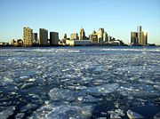
The Detroit River supplies the drinking water for over five million people. It was also designated an American Heritage River in 1998, and a Canadian Heritage River in 2003, the only river in North America to have dual designations. A shipping channel for the Great Lakes Waterway system is maintained in the river. The river flows past the American cities of Detroit, River Rouge, Ecorse, Wyandotte, Grosse Ile, Riverview, Trenton, and Gibraltar and the Canadian cities of Windsor, LaSalle, and Amherstburg.
Vessels
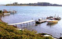
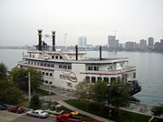
The Detroit River is a major transportation artery, as well as place of recreation for pleasure boaters.
Bridges and crossings
This is a list of bridges and other crossings of the Detroit River from Lake Erie upstream to Lake St. Clair.
| Crossing | Carries | Location | Coordinates |
|---|---|---|---|
| Wayne County Bridge | Trenton, Michigan and Grosse Ile Township, Michigan | ||
| Grosse Ile Toll Bridge | Riverview, Michigan and Grosse Ile Township, Michigan | ||
| Detroit-Windsor Truck Ferry | Detroit, Michigan and Windsor, Ontario | ||
| Ambassador Bridge | |||
| Michigan Central Railway Tunnel | Canadian Pacific Railway | ||
| Detroit-Windsor Tunnel | Highway 3B |
||
| MacArthur Bridge | Detroit, Michigan and Belle Isle, Michigan |
See also
- Belle Isle Park
- Great Lakes
- Hart Plaza
- Lake Saint Clair (North America)
- List of Michigan rivers
- List of Ontario rivers
- Renaissance Center
- Detroit-Windsor
- Windsor-Detroit International Freedom Festival
References
- ↑ Nolan, Jenny. "How the Detroit River shaped lives and history". Retrieved on 2007-02-12.
- ↑ [1] Riverfront Conservancy FAQ page
External links
- Detroit Riverfront Conservancy
- Detroit River, Canadian Heritage River site
- Greater Detroit American Heritage River Initiative
- US EPA page on Detroit River
- Sea Grant Michigan
|
||||||||||||||||||||||||||||||||
|
|||||||||||
|
|||||||||||||||||||||||||||||