Derbyshire
 |
|
| Geography | |
| Status | Ceremonial & (smaller) Non-metropolitan county |
|---|---|
| Region | East Midlands |
| Area - Total - Admin. council - Admin. area |
Ranked 21st 2,625 km² Ranked 20th 2,547 km² |
| Admin HQ | Matlock |
| ISO 3166-2 | GB-DBY |
| ONS code | 17 |
| NUTS 3 | UKF12/13 |
| Demographics | |
| Population - Total (2007 est.) - Density - Admin. council - Admin. pop. |
Ranked 20th 996,000 379 / km² Ranked 11th 758,100 |
| Ethnicity | 96.0% White 2.3% S.Asian, 1.7% Black British, Mixed Race or Chinese |
| Politics | |
Derbyshire County Council http://www.derbyshire.gov.uk/ |
|
| Executive | Labour |
| Members of Parliament | |
| Districts | |
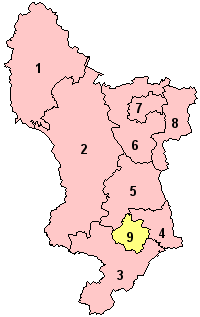 1.High Peak 2.Derbyshire Dales 3.South Derbyshire 4.Erewash 5.Amber Valley 6.North East Derbyshire 7.Chesterfield 8.Bolsover 9.Derby (Unitary) |
|
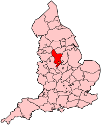
Derbyshire (pronounced /ˈdɑrbɪʃər/ DAR-bi-shər or /ˈdɑrbɪʃɪər/ DAR-bi-sheer; listen) is a county in the East Midlands of England. A substantial portion of the Peak District National Park lies within Derbyshire. The northern part of Derbyshire overlaps with the Pennines, a famous chain of hills and mountains. The county contains part of the National Forest, and borders on Greater Manchester, West Yorkshire, South Yorkshire, Nottinghamshire, Leicestershire, Staffordshire and Cheshire. Derbyshire can make some claims to be at the centre of Britain: a farm near Coton in the Elms has been identified as the furthest from the sea, whilst Rodsley and Overseal were the centres of population during the twentieth century[1].
The city of Derby is now a unitary authority area, but remains part of the ceremonial county of Derbyshire. The non-metropolitan county contains 30 towns with between 10,000 and 100,000 inhabitants. There is a large amount of sparsely populated agricultural upland: 75% of the population live in 25% of the area. Although Derbyshire is in the East Midlands, some parts, such as High Peak, are closer to the northern cities of Manchester and Sheffield and these parts do receive services which are more affiliated with Northern England, for example North West Ambulance Service, Granada Television, united utilities serve the High Peak and some NHS Trust within this region are governed by the Greater Manchester Health Authorities. Outside the main city of Derby, the largest town in the county is Chesterfield.
Contents |
History
The area that is now Derbyshire was first visited, probably briefly, by humans 200,000 years ago during the Aveley interglacial as evidenced by a Middle Paleolithic Acheulian hand axe found near Hopton.[2]. Further occupation came with the Upper Paleolithic and Neolithic periods of the Stone Age when Mesolithic hunter gatherers roamed the hilly tundra.[3] The evidence of these nomadic tribes is centred around limestone caves located on the Nottinghamshire border. Desposits left in the caves date the occupancy at around 12,000 to 7,000 BCE.[4]
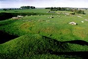
Burial mounds of Neolithic settlers are also situated throughout the county. These chambered tombs were designed for collective burial and are mostly located in the central Derbyshire region.[4] There are tombs in Minning Low, and Five Wells, which date back to between 2000 and 2500 BCE[5] Three miles west of Youlgreave lies the Neolithic henge monument of Arbor Low, This can be dated back to 2500 BCE.
It is not until the Bronze Age that real signs of agriculture and settlement are found in the county. In the moors of the Peak District signs of clearance, arable fields and hut circles were discovered after archeological investigation. However this area and another settlement at Swarkestone are all that have been found.[6]
During the Roman invasion the invaders were attracted to Derbyshire because of the lead ore in the limestone hills of the area. They settled throughout the county with forts built near Brough in the Hope Valley and near Glossop. Later they settled around Buxton, famed for its warm springs, and set up a fort near modern day Derby in an area now known as Little Chester.[6]
Several kings of Mercia are buried in the Repton area.[7]
Following the Norman Conquest, much of the county was subject to the forest laws. To the North West was the Forest of High Peak under the custodianship of William Peverel and his descendants. The rest of the county was bestowed upon Henry de Ferrers, a part of it becoming Duffield Frith. In time the whole area was given to the Duchy of Lancaster. Meanwhile the Forest of East Derbyshire covered the whole county to the east of the River Derwent from the reign of Henry II to that of Edward I.[8]
Economy
Derbyshire is a mixture of a rural economy in the west, with a former coal mining economy in the north east (Bolsover district), the Erewash Valley around Ilkeston and in the south around Swadlincote. The landscape varies from typical arable country in the flat lands to the south of Derby, to the hill farming of the high gritstone moorlands of the southern Pennines, which effectively begin to the north of the city. This topology and geology has had a fundamental effect on Derbyshire's development throughout its history. In addition it is rich in natural resources like lead, iron, coal, and Limestone. The limestone outcrops in the central area led to the establishment of large quarries to supply the industries of the surrounding towns with lime for building and steel making, and latterly in the 20th century cement manufacture. The industrial revolution also increased demand for building stone and in the late 19th & early 20th century the railways arrival led to a large number of stone quarries to exploit the natural resources of the area. This industry has left its mark on the countryside but is still a major industry a lot of the stone is supplied as crushed stone for road building and concrete manufacture and is moved by rail. The Limestone areas of central Derbyshire were found to contain veins of lead ore and these were mined from roman times.
Its remoteness in the late 18th century and an abundance of fast flowing streams led to a proliferation of water power at the beginning of the Industrial Revolution, following the mills pioneered by Richard Arkwright. For this reason amongst others, Derbyshire has been said to be the home of the Industrial Revolution, and part of the Derwent Valley has been given World Heritage status.
Nationally famous companies in Derbyshire are Thorntons just south of Alfreton and JCB subsidiary JCB-Power Systems have an engine factory in South Derbyshire. Ashbourne Water used to be bottled in Buxton by Nestlé Waters UK until 2006 and Buxton Waterstill is. Other major employers in the county especially around the Derby area are Rolls-Royce plc, Egg Banking plc and Toyota.
Politics
- See also: Derbyshire local elections
Derbyshire has a three-tier local government since the local government reorganisation in 1974. It has a county council based in Matlock and eight district councils and since 1998, a unitary authority of Derby. However, Derby remains part of Derbyshire for ceremonial purposes.
At the third tier are the parish councils, which do not cover all areas. The eight district councils in Derbyshire and the unitary authority of Derby are shown in the map to the right.
These district councils are responsible for local planning and building control, local roads, council housing, environmental health, markets and fairs, refuse collection and recycling, cemeteries and crematoria, leisure services, parks, and tourism.[9] Education, social services, libraries, main roads, public transport, policing and fire services, trading standards, waste disposal and strategic planning are the responsibility of the County Council.[9]
The county is divided into ten constituencies for the election of Members of Parliament (MPs) to the House of Commons. As of November 2007, the constituencies of Amber Valley, Bolsover, Derby North, Derby South, Erewash, High Peak, North East Derbyshire and South Derbyshire elected Labour MPs, while Chesterfield elected a Liberal Democrat MP and West Derbyshire elected a Conservative MP.[10] Derbyshire residents are part of the electorate for the East Midlands constituency for elections to the European Parliament.[11]
Education

For a list of individual schools see Category:Schools in Derbyshire
The Derbyshire school system is comprehensive with no selective schools. There is selection by average house price in some areas.
Settlements
This is a list of the towns in Derbyshire.
Sport
The county has two football teams currently playing in the Football League: Derby County F.C. and Chesterfield F.C. There are also many non-league teams playing throughout the county, most notably Alfreton Town F.C. who play in the Conference North. The county is also now home to the world's oldest football club, Sheffield F.C. who have their home ground at Dronfield in North East Derbyshire.
The most successful team is Derby County, who were one of the founding members of the Football League and have played professionally since then. In the 1945-46 season they won the FA Cup and they were champions of the Football League First Division in 1971-72 and 1974-75. On the back of their championship season of 1972-73 they reached the semifinal of the European Cup. This was their highest placing in a major European tournament. More recently they have been relegated to the Football League Championship after finishing last in the Premier League with only one win all season.
Chesterfield F.C are the fourth oldest club in the country[12] but have been less successful over their 141 years of existence than the larger Derby County. They are currently in league two after being promoted in 2001 despite being fined nine points for financial irregularities. Their highest position is fourth in the second division at the end of the 1946-47 season. The team's most notable achievement of recent years occurred in 1997, when they reached the semi-final of the FA Cup, losing to Middlesbrough in a replay following a 3-3 draw at Old Trafford.
As well as football, Derbyshire also has a cricket team based at the County Cricket Ground. Derbyshire County Cricket Club currently play in Division two of the County Championship. There are also rugby league clubs based in Chesterfield, the Chesterfield Spires, and in Derby (Derby City RLFC).
Recreational Sports
The county is a popular are for a variety of recreational sports such as Rock Climbing, Hill walking, Mountaineering, Sailing on its many reservoirs, and cycling along the many miles of disued rail tracks that have been turned into cycle trails, such as the Monsal Trail & High Peak Trail.
Local Attractions

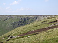
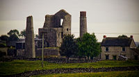
The county of Derbyshire offers many attractions for both tourists and local people. The county offers the spectacular Peak District scenery such as Mam Tor, Kinder Scout, and other more metropolitan attractions like Bakewell, Buxton, and Derby. Local places of interest include; Bolsover Castle, Castleton, Chatsworth House, Crich Tramway Museum, Cascades Gardens [13], Dovedale Haddon Hall, Heights of Abraham, and the Matlock Bath.[14]
In the north of the county, three large reservoirs, Howden, Derwent and Ladybower, were built during the early part of the 20th century to supply the rapidly growing populations of Sheffield, Derby and Leicester with drinking water. The land around these is now extensively used for leisure pursuits like walking and cycling, as the surrounding catchment area of moorland is protected from development, as part of the Peak District National Park.
There are many properties and lands in the care of the National Trust, located in Derbyshire that are open to the public such as Calke Abbey, Hardwick Hall, High Peak Estate, Ilam Park, Kedleston Hall, Longshaw Estate near Hathersage, and Sudbury Hall on the Staffordshire Border.
County emblems
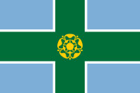
As part of a 2002 marketing campaign, the plant conservation charity Plantlife chose the Jacob's Ladder as the county flower.
In 2006, an unofficial county flag was introduced, largely on the initiative of BBC Radio Derby in September 2006[15]. The flag consists of a St. George cross encompassing a golden Tudor Rose, which is a historical symbol of the county. The blue field represents the many waters of the county, its rivers and reservoirs, while the cross is green to mark the great areas of countryside.
Demographics
| Derbyshire Compared | |||||
|---|---|---|---|---|---|
| UK Census 2001 | Derby[16] | Derbyshire[17] | East Midlands | England | |
| Total population | 221,708 | 734,585 | 4,172,174 | 49,138,831 | |
| Foreign born (outside Europe) | 6.7% | 1.4% | 4.5% | 6.9% | |
| White | 87.5% | 98.5% | 93.5% | 91.0% | |
| Asian | 8.4% | 0.5% | 4.1% | 4.6% | |
| Black | 1.8% | 0.2% | 1.0% | 2.3% | |
| Christian | 67.4% | 77.0% | 72.0% | 71.7% | |
| Muslim | 4.5% | 0.2% | 1.7% | 3.1% | |
| Hindu | 0.6% | 0.1% | 1.6% | 1.1% | |
| No religion | 15.9% | 14.7% | 16.0% | 14.6% | |
| Over 65 | 16.1% | 16.7% | 16.1% | 16.0% | |
| Unemployed | 4.0% | 3.2% | 3.3% | 3.3% | |
In 1801 the poulation was 147,481[18][19] According to the UK Census 2001 there were 956,301 people spread out over the county's 254,615 hectares.[20] This was estimated to have risen to 990,400 in 2006.[21]
The county's population grew by 3.0% from 1991 to 2001 which is around 21,100 people. This figure is higher than the national average of 2.65% however it is lower than the East Midlands average of 4.0%. The county as a whole has an average population density of 2.9 people per hectare making it less densely populated than England as a whole.[22] The density varies considerably throughout the county with the lowest being in the region of Derbyshire Dales at 0.88, and highest outside of the main cities in the region of Erewash which has 10.04 people per hectare.[17]
| Population since 1801 | |||||||||||||
| Year | 1801 | 1851 | 1901 | 1911 | 1921 | 1931 | 1939 | 1951 | 1961 | 1971 | 1981 | 1991 | 2001 |
|---|---|---|---|---|---|---|---|---|---|---|---|---|---|
| Derbyshire non-metropolitan county[18] |
132,786 | 223,414 | 465,896 | 542,697 | 565,826 | 590,470 | 613,301 | 637,645 | 651,284 | 666,013 | 687,404 | 717,935 | 734,585 |
| Derby unitary authority[19] |
14,695 | 48,506 | 118,469 | 132,188 | 142,824 | 154,316 | 167,321 | 181,423 | 199,578 | 219,558 | 214,424 | 225,296 | 221,716 |
| Total as a ceremonial county |
147,481 | 271,920 | 584,365 | 674,885 | 708,650 | 744,786 | 780,622 | 819,068 | 850,862 | 885,571 | 901,828 | 943,231 | 956,301 |
In popular culture
In Jane Austen's novel Pride and Prejudice, the country home of Fitzwilliam Darcy, Pemberley, is in Derbyshire.
See also
- Derbyshire lead mining history
- List of football clubs in Derbyshire
References
- ↑ "Appleby Magna - centre of Britain Appleby Parva: Centre of the Country!". Retrieved on 2008-01-07.
- ↑ Cockerton, R. W. P. 1954 A Palaeolith from Hopton, Derbyshire Archaeological Journal 79: 153-155
- ↑ Smith, pp. 6
- ↑ 4.0 4.1 Pevsner, pp. 22
- ↑ Smith, pp. 7
- ↑ 6.0 6.1 Smith, pp. 8
- ↑ "Repton in Derbyshire". Derbyshire UK. Retrieved on 2008-01-07.
- ↑ Barret, Dave. "Derbyshire County Council, East Midlands Archaeological Research Framework: Resource Assessment of Medieval Derbyshire" (PDF). Retrieved on 2008-01-07.
- ↑ 9.0 9.1 "Glossary of Local Government Terms". The Local Channel. Retrieved on 2008-01-07.
- ↑ "Alphabetical List of Members of Parliament". Parliament UK. Retrieved on 2008-01-11.
- ↑ "UK MEPs for the East Midlands". European Parliament UK Office. Retrieved on 2008-01-30.
- ↑ BBC Sport (2002-01-17). "Spireites takeover bid backed" (HTML). BBC. Retrieved on 2008-01-31.
- ↑ Cascades Gardens, retrieved 19.03.08
- ↑ Local Attractions, retrieved 19.03.08
- ↑ "Revealed - The Derbyshire Flag". www.BBC.co.uk. Retrieved on 2008-01-07.
- ↑ United Kingdom Census 2001 (2001). "Area: Derby (Local Authority)". neighbourhood.statistics.gov.uk. Retrieved on 2007-10-24.
- ↑ 17.0 17.1 United Kingdom Census 2001 (2001). "Area: Derbyshire (Education Authority)". neighbourhood.statistics.gov.uk. Retrieved on 2007-10-24.
- ↑ 18.0 18.1 "Derbyshire: Total Population". A Vision of Britain Through Time. Great Britain Historical GIS Project. Retrieved on 2008-01-29.
- ↑ 19.0 19.1 "Derby UA: Total Population". A Vision of Britain Through Time. Great Britain Historical GIS Project. Retrieved on 2008-01-31.
- ↑ "Derbyshire: Total area, in hectares". A Vision of Britain Through Time. Great Britain Historical GIS Project. Retrieved on 2008-01-29.
- ↑ "T 09: Quinary age groups and sex for local authorities in the United Kingdom; estimated resident population Mid-2006 Population Estimates". Office for National Statistics. Retrieved on 2007-10-20.
- ↑ Research and Information Team (2003-03-19). "2001 Census: Key Statistics for Derbyshire". derbyshiredales.gov.uk. Retrieved on 2008-01-29.
Further reading
- Smith, Roly (1999). Towns & Villages of Britain: Derbyshire. Cheshire: Sigma Press. ISBN 1850586225.
- Pevsner, Nikolaus (1953). The Buildings of England: Derbyshire. Middlesex: Penguin Books. ISBN 0140710086.
- Pevsner & Williamson, Elizabeth (1978). The Buildings of England: Derbyshire. Penguin Books. ISBN 0140710086.
External links
|
|||||||||||||||||
|
|||||