Curitiba
| Curitiba | |||
| — Municipality — | |||
| The Municipality of Curitiba | |||
 |
|||
|
|||
| Nickname(s): Ctba | |||
| Motto: 'A Cidade da Gente' (Our City) | |||
 |
|||
 |
|||
| Coordinates: | |||
| Country | |||
|---|---|---|---|
| Region | South | ||
| State | |||
| Founded | March 29, 1693 | ||
| Incorporated | 1842 | ||
| Government | |||
| - Mayor | Carlos Alberto Richa (PSDB) | ||
| Area | |||
| - Municipality | 430.9 km² (166.4 sq mi) | ||
| - Metro | 15,416.9 km² (5,952.5 sq mi) | ||
| Elevation | 934.6 m (3,066.3 ft) | ||
| Population (2007) | |||
| - Municipality | 1,797,408 (7th) | ||
| - Density | 4,159.4/km² (10,748.5/sq mi) | ||
| - Metro | 3,261,168 | ||
| - Metro Density | 210.9/km² (546.2/sq mi) | ||
| Time zone | UTC-3 (UTC-3) | ||
| - Summer (DST) | UTC-2 (UTC-2) | ||
| CEP | 80000-000 to 82999-999 | ||
| Area code(s) | 41 | ||
| HDI (2000) | 0.856 – high | ||
| Website: Curitiba, Paraná | |||
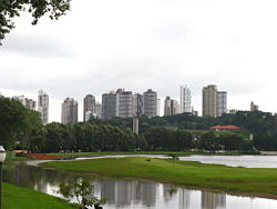
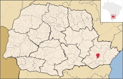
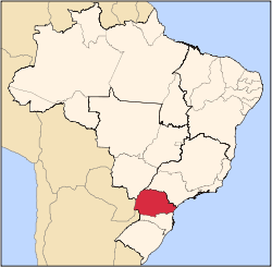
Curitiba (pron. IPA: [kuɾi'tibɐ] or IPA: [kuɾi'tʃibɐ]) is the capital city of the Brazilian state of Paraná. The city has the largest population and also the largest economy in Southern Brazil. The population of Curitiba numbers approximately 1.8 million people (7th largest nationwide) and the latest GDP figures for the city surpass US$17 billion (ranking 4th nationwide) according to IBGE.[1]
Its metropolitan area comprises 26 municipalities[2] with a total population of over 3.5 million (IBGE estimate in 2006).[3] Curitiba is an important cultural, political and economic center in the country. The city is sits on a plateau at 932 metres (3,060 ft) above sea level. It is located 105 kilometres (65 mi) west of the sea port of Paranaguá and hosts the Afonso Pena International Airport.
One theory about the name "Curitiba" comes from the Tupi words kurí tyba, "many pine" due to the large number of Brazilian Pines (Araucaria angustifolia), in the region prior to its foundation.[4] The Portuguese who founded a village in 1693 gave it the name of "Vila da Nossa Senhora da Luz dos Pinhais" (Our Lady of the Light in the Pine Forest). The name was changed to "Curitiba" in 1721. Curitiba officially became a town in 1812, spelling its name as Curityba. An alternative spelling also came up: Coritiba. This spelling looked to become dominant for it was used in press and state documents, but a state decree in 1919 settled the dispute by spelling the city name Curitiba.[4]
Growth was based on the cattle trade, being half way between cattle breeding country to the South and markets to the North. Waves of European immigrants started arriving after 1850, mainly Germans, Italians, Poles and Ukrainians contributing to the economic and cultural development of the city.
Curitiba hosts the Universidade Federal do Paraná (Federal University of Paraná), the first in Brazil, was established in Curitiba in 1913, the same year in which electric streetcars were first deployed.
Contents |
Climate
| for Curitiba | |||||||||||||||||||||||||||||||||||||||||||||||
|---|---|---|---|---|---|---|---|---|---|---|---|---|---|---|---|---|---|---|---|---|---|---|---|---|---|---|---|---|---|---|---|---|---|---|---|---|---|---|---|---|---|---|---|---|---|---|---|
| J | F | M | A | M | J | J | A | S | O | N | D | ||||||||||||||||||||||||||||||||||||
|
183
26
16
|
140
26
17
|
127
25
16
|
81
23
13
|
107
21
11
|
96
19
9
|
93
19
8
|
71
20
9
|
110
20
10
|
126
22
12
|
114
24
14
|
157
25
15
|
||||||||||||||||||||||||||||||||||||
| temperatures in °C precipitation totals in mm source: [1]SIMEPAR |
|||||||||||||||||||||||||||||||||||||||||||||||
|
Imperial conversion
|
|||||||||||||||||||||||||||||||||||||||||||||||
Located in Southern Brazil, Curitiba is a somewhat humid city in a Subtropical zone. It is located in a plateau and the flat terrain with flooded areas contribute to its mild and damp winter, with average temperatures of 13 °C (55 °F) in the coldest month, falling slightly below 0 °C (32 °F), on the coldest days. During summer, the average temperature is around 21 °C (70 °F), but gets above 32 °C (90 °F) on hot days. It received snowfall in 1928,1942 and 1975. The highest temperature ever recorded in the city was 35.6 °C (96.1 °F). The all-time record lowest temperature was −8 °C (17.6 °F), but there is an unofficial record of −10.4 °C (13 °F).
In fact, of Brazil's twenty-six state capitals, Curitiba is the coldest due to altitude, despite being 600 kilometres (370 mi) north of Porto Alegre, the southernmost state capital in Brazil, but located at sea level.
Heat waves during winter and cold waves during summer are not uncommon, and even within a single day there can be great variation, a typical feature of subtropical climates. Several factors contribute to the climate's variable nature:
- The flat terrain surrounded by mountains in a rough circle with radius 40 kilometres (25 mi)help block the winds, allowing the morning mist to cover the city on cold mornings.
- The flatness of the terrain hinders quick water drainage after rains, therefore providing a good source of water vapor for the atmosphere.
- Cold fronts come often from Antarctica and Argentina all year round, bringing tropical storms in summer and cold winds in winter. They can move very quickly, with no more than one day between the start of the southern winds and the start of rain.
- Curitiba's weather is also influenced by the dry air masses that dominate Brazil's midwest most of the year, bringing hot and dry weather, sometimes even in winter.
Urban planning


Curitiba has a master planned transportation system, which includes lanes on major streets devoted to a bus rapid transit system. The buses are long, split into three sections (bi-articulated), and stop at designated elevated tubes, complete with disabled access. There is only one price no matter how far you travel and you pay at the bus stop.[5] The system, used by 85% of Curitiba's population, is the source of inspiration for the TransMilenio in Bogotá, Colombia, Metrovia in Guayaquil, Ecuador,as well as the Orange Line of Los Angeles, California, and for a future transportation system in Panama City, Panama. The city has also paid careful attention to preserving and caring for its green areas, boasting 54 square metres (580 sq ft) of green space per inhabitant.[6]
In the 1940s and 1950s, Alfred Agache, cofounder of the French Society for Urban Studies, was hired to produce the first city plan. It emphasised a star of boulevards, with public amenities downtown, an industrial district and sanitation. It was followed when possible, but was too expensive to complete.[7]
By the 1960s, Curitiba's population had ballooned to 430,000, and some residents feared that the growth in population threatened to drastically change the character of the city. In 1964, Mayor Ivo Arzua solicited proposals for urban design. Architect Jaime Lerner, who later became mayor, led a team from the Universidade Federal do Paraná that suggested strict controls on urban sprawl, a reduction of traffic in the downtown area, preservation of Curitiba's Historic Sector, and a convenient and affordable public transit system.[8]
This plan, known as the Curitiba Master Plan, was adopted in 1968. Lerner closed XV de Novembro St. to vehicles, because it had very high pedestrian traffic. The plan had a new road design to minimise traffic: the Trinary Road System. This uses two one-way streets moving in opposite directions which surround a smaller, two-lane street where the express buses have their exclusive lane. Five of these roads form a star that converges to the city centre. Land farther from these roads is zoned for lower density developments, to reduce traffic away from the main roads. A number of areas subject to floods were condemned and became parks.
Today, Curitiba is considered one of the best examples of urban planning worldwide.[9] In June 1996, the chairman of the Habitat II summit of mayors and urban planners in Istanbul praised Curitiba as "the most innovative city in the world."
In the 1980s, the RIT (Rede Integrada de Transporte, Integrated Transport Network) was created, allowing transit between any points in the city by paying just one fare. At the same time, the city began a project called the "Faróis de Saber" (Lighthouses of Knowledge). These Lighthouses are free educational centers which include libraries, Internet access, and other cultural resources. Job training, social welfare and educational programs are coordinated, and often supply labor to improve the city's amenities or services, as well as education and income.
Demographics

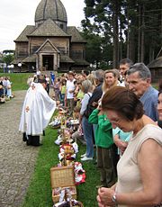
According to the IBGE of 2007, there were 3,230,000 people residing in the Metropolitan Region of Curitiba. The population density was 4,159.4 inhabitants per square kilometre (10,773 /sq mi). The last PNAD (National Research for Sample of Domiciles) census revealed the following numbers: 2,503,250 White people (77.4%), 584,000 Pardo (Brown) people (18.2%), 93,000 Black people (2.9%), 45,000 Asian or Amerindian people (1.4%).[10]
As most of Southern Brazil's population, Curitiba is mostly inhabited by Brazilians of European descent. The first Europeans to arrive in the region were of Portuguese origin, during the 17th century. They intermarried with the native people and with the African slaves.[11]
In the 19th century, the influx of immigrants from Europe increased. In 1828, the first German immigrants settled in Paraná. However, large numbers of immigrants from Germany only arrived in Curitiba during the 1870s, most of them coming from Santa Catarina or Volga Germans from Russia.[12]
Immigrants from Poland first arrived in 1871, settling in rural areas close to Curitiba. They largely influenced the agriculture of the region. Curitiba has the second largest Polish diaspora in the world, second only to Chicago.[11] Italian immigrants started arriving in Brazil in 1875 and in Curitiba in 1878. They came mostly from the Veneto and Trento regions, in Northern Italy and settled mostly in the Santa Felicidade neighborhood, still today the center of the large Italian community of Curitiba.[13]
Large numbers of Ukrainian immigrants settled in Curitiba, mostly between 1895 and 1897, when 20 thousands arrived. They were peasants from Galicia, who immigrated to Brazil to become small farmers. Nowadays there are 300 thousand Ukrainian-Brazilians living in Paraná.[14][15]
Curitiba has a well established Jewish community[16] originally established in the 1870s.[17] Much of the early Jewish congregation has been assimilated.[18] In 1937 with the rise of Nazi power, several notable German Jewish Academics were allowed into Brazil, some of them settling in Curitiba.[19] Physicist César Lattes and former mayors Jaime Lerner,[20] Saul Raiz and Nei Braga were Jewish. A monument in memory of the Holocaust has been erected in the city. There is also a Habad house in Curitiba "Beit Chabad" as well as at least two synagogues[21] and two Jewish cemeteries,[22] one of which was defiled by antisemites in 2004[23].
Japanese immigrants began arriving in the region in 1915. Most Japanese settled in the state of São Paulo, but many settled in Northern Paraná, cities such as Maringá and Londrina. Curitiba also received significant numbers of immigrants from Japan. Nowadays, there are about 40 thousand Japanese-Brazilians living in the city.[24]
Other immigrants, such as Arabs from Lebanon and Syria, Russians and other Eastern Europeans also settled in Curitiba.
Economy
According to IPEA data, the GDP is estimated at real 29 billion, without recording activities in the agriculture and livestock farming (0.03%) sectors. Industry represented 34.13% and the commerce and service sectors 65.84%.
Cidade Industrial de Curitiba, the industrial district of Curitiba, is home to many multinational industries, such as Nissan, Renault, Volkswagen, Audi, HSBC, Siemens, ExxonMobil, and Kraft Foods, as well as many national industries, such as Sadia, O Boticário, Positivo Informática. The city attracts diverse industries through its excellent infrastructure (hotels, transportation, restaurants). Curitiba's infrastructure makes bus travel fast and convenient, effectively creating demand for bus use in the same way that the infrastructure of traditional cities creates demand for private motor vehicles.
The GDP for the city is R$ 29,821,203,000 (2005).[25]
The per capita income for the city was R$ 16,964 (2005).[26]
Education

Portuguese is the official national language, and thus the primary language taught in schools. But English and Spanish are part of the official high school curriculum.
Educational institutions include
- Universidade Federal do Paraná (UFPR);
- Universidade Tecnológica Federal do Paraná (UTFPR);
- Pontifícia Universidade Católica do Paraná (PUCPR);
- Universidade Tuiuti do Paraná (UTP);
- Universidade Positivo (UP);
- Centro Universitário Franciscano do Paraná (UNIFAE);
- Faculdade de Tecnologia (FATEC);
- Faculdade Curitiba;
- and many others.
Tourism and recreation


24 Horas Street
The Street that never sleeps is the synthesis of a city which also never sleeps. It is 120 meters long and 12 meters wide. It is composed by 32 arches in metallic tubular structure, trademark of the modern curitibana architecture.
Botanic Gardens
Curitiba’s trademark, created to resemble French gardens, rolls out its flower carpet to the visitors right at the entrance. The greenhouse, with a metallic structure, has botanic species that are national reference, and also a water fountain.
The native forest is filled with paths for walking. The Botanic Museum attracts researchers from all over the world. There is a space for exhibitions, library and a theatre.
German Woods
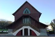
The wood has various features to celebrate and promote the German traditions. There are 38 thousand square meters of native forest, which was part of the old farm from the Schaffer family. The replica of an old wooden church, built in 1933 at the Seminário neighbourhood, with neo-gothich decorative elements, shelters a concert hall called Bach’s Oratorium.
Other attractions are the John and Mary path, which tells the Grimm brothers tale, a children’s library, the Philosophers Tower, a wooden observatory allowing a panoramic view of the city and the Ocean Ridge, and the German Poetry Square, with a reproduction of the Casa Mila façade, a German building from the beginning of the last century, originally located in the city centre. It's closed for remodeling at the present time.
Italian Woods
A place for the typical parties of the Italian community in the district, such as the Grape Party, the Wine Party and the 4 Giorni in Italy. It has structure for food and drinkstalls, space for shows and folkloric presentations and a polenta pot.
Japan Square
Homage to Japanese immigrants who settled there dedicating themselves to agriculture. Scattered around the square are 30 cherry trees sent from Japan and artificial lakes. In 1993 the Japanese Portal, the Culture House and the Tea House were built.
Tingüi Park
Part of the biggest linear environmental park in the Country, established at the Barigüi river margins, it reminds us of the Indians who used to live there, with the statue of Tindiqüera Chieftain. The Ukrainian Memorial is also there, homage to the immigrants, in a replica of an orthodox church, originally built in inland Paraná State, hosting a pêssankas and icons exhibition.
Wire Opera House
It is one of the emblematic symbols of Curitiba, with tubular structure and transparent ceiling, of great beauty. Inaugurated in 1992, it caters for all types of shows, between lakes, typical vegetation and cascades, on a unique landscape. The Wire Opera House is part of the Pedreiras Park, together with the Paulo Leminski Cultural Space, where the Passion of Christ was enacted, and hosted many other big events since 1989, and can receive, in open air, 10 thousand people seating or 50 thousand standing.
Tanguá Park
This park was inaugurated in 1996, the Tanguá Park surprises with its beauty as an example of urban space being re-utilized - on one old complex of disactivated quarries -, and it is part of the Barigüi river preservation project joining Tingüi and Barigüi parks. This park with an area of 450 thousand square meters has two quarries connected by a 45 meter tunnel that may be crossed on foot by a path over the water. It can be visited on boat or on foot (hiking). The park has a cooper and bicycle track, snack bar, belvedere and Poty Lazzaroto garden.
Portugal Wood
Homage to the Portuguese-Brazilian bonds, this space is highlighted by a track following a small brook, where one can see drawn on tiles excerpts from famous Portuguese language poets, as well as a tribute to the great Portuguese navigators and their discoveries.
Transport
Public Transport


Curitiba has a unique transportation system, developed locally and causing much interest worldwide[27]. This Bus Rapid Transit system, is very simple and practical. Public transportation consists entirely of buses. There are several different types of bus, each with a different function. All stations are easily accessed, are enclosed, and the busses have been changed to make for easier entry and exit[28]. Together with other low-cost changes, this bus system aims at becoming a comfortable and preferred transportation choice for the public[29].
Roads
Moving around in a car can be difficult in and around the city centre because of the many one-way streets and frequent traffic jams. This makes the public transportation system more attractive if one wants to go there. The trinary system allows quick access to the city centre for car drivers. Some avenues are spacious and laid out in a grid, and apart from some points around the city centre, Munhoz da Rocha Street and Batel Avenue, traffic jams are not thus severe.
Recently, the city installed around 200 traffic radars, causing much discontent among drivers in general.
International Airport
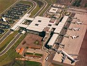
Afonso Pena International Airport is Curitiba's main airport. It is located in the nearby city of São José dos Pinhais and all commercial flights operate from this airport. (Small aircraft may also use the Bacacheri airport.) It is integrated into Curitiba's transportation system, with rapid buses and shuttle service connecting the airport to the city.
Sports


Curitiba provides visitors and residents with various sport activities. There are several soccer clubs based in Curitiba. The most important ones - Brazilian mid-class clubs - are:
Coritiba Foot Ball Club
- Campeonato Brasileiro Série A champion in 1985.
- Campeonato Brasileiro Série A champion in 2001.
Paraná Clube
- Campeonato Brasileiro Série B champion in 1992 and 2000.
Stadiums:
- Coritiba Foot Ball Club: Estádio Major Antônio Couto Pereira, Capacity: 37,182
- Clube Atlético Paranaense: Estádio Joaquim Américo Guimarães, Capacity: 25,272
- Paraná Clube: Estádio Durival Britto e Silva, Capacity: 24,303.
Curitiba is one of the 18 remaining candidates to host games of the 2014 FIFA World Cup to be held in Brazil.[30]
Arts and entertainment
Curitiba is the first city in Brazil to have an IMAX cinema. It is in the Palladium Shopping Center[31] which is the biggest mall in Southern Brazil.
Curitiba also has many Theaters. The biggest and most important one is the "Guaíra Theater".[32]
Every year, in April, it hosts the "Curitiba Theater Festival",[33] with various artists playing in Curitiba Theaters and even on the squares.
Neighborhoods

Bairros (neighbourhoods) of Curitiba are geographical divisions of the city. There is no delegation of administrative powers to neighborhoods, although there are several neighborhoods associations devoted to improve their own standards of living. Curitiba is divided into 9 regional governments (boroughs) covering the 75 neighbourhoods of the city. All districts are served by the system of integrated urban transport.
Most districts of Curitiba was born of colonial groups formed by families of European immigrants in the second half of the nineteenth century.
The centre ("Downtown" in American English or "CBD" - central business district - in other English use), place of foundation of the city, is the most bustling area, which concentrates most of the financial institutions of Curitiba.
List of neighborhoods by regional:
- Matriz: Centro, Centro Cívico, Batel, Bigorrilho, Mercês, São Francisco, Bom Retiro, Ahu, Juvevê, Cabral, Hugo Lange, Jardim Social, Alto da XV, Alto da Glória, Cristo Rei, Jardim Botânico, Prado Velho and Rebouças;
- Santa Felicidade: Santa Felicidade, Lamenha Pequena, Butiatuvinha, São João, Vista Alegre, Cascatinha, São Brás, Santo Inácio, Orleans, Mossunguê, Campina do Siqueira, Seminário, CIC (north region) and part of Campo Comprido;
- Boa Vista: Boa Vista, Bacacheri, Bairro Alto, Tarumã, Tingüi, Atuba, Santa Cândida, Cachoeira, Barreirinha, Abranches, Taboão, Pilarzinho and São Lourenço;
- Cajuru: Cajuru, Uberaba, Jardim das Américas, Guabirotuba and Capão da Imbuia;
- Fazendinha/Portão: Portão, Fazendinha, Santa Quitéria, Vila Isabel, Água Verde, Parolin, Guaíra, Lindóia, Fanny, Novo Mundo and part of Campo Comprido;
- Boqueirão: Boqueirão, Xaxim, Hauer and Alto Boqueirão;
- Pinheirinho: Pinheirinho, Capão Raso, Tatuquara, Campo de Santana and Caximba;
- Bairro Novo: Sítio Cercado, Ganchinho and Umbará;
- Cidade Industrial de Curitiba: CIC (center and south region), Riviera, Augusta and São Miguel.
Sister cities
The Sister Cities of Curitiba are:
 Asunción (Paraguay)[34]
 Coimbra (Portugal)[35]
 Córdoba (Argentina)[36]
 Corrientes (Argentina)[36]
 Guadalajara (Mexico)[34]
 Hangzhou (China)[34]
 Himeji (Japan)[34]
 Krakow (Poland)[37]
 Lyon (France)[38]
 Montevideo (Uruguay)[34]
 Orlando (USA)[39]
 Santa Cruz de la Sierra (Bolivia)[34]
 Suwon (South Korea)[34]
 Treviso (Italy)[40]
Famous places

Curitiba is mostly known for some of its famous places:
- Autódromo Internacional de Curitiba
- Bosque Alemão
- Bosque de Portugal
- Feirinha do largo da ordem
- Jardim Botânico de Curitiba
- Ópera de Arame
- Rua XV de Novembro
- Universidade Federal do Paraná
Curitiba's famous people


Arts
- Isabeli Fontana - Super Model
- Poty Lazzarotto - Plastic Artist
- Paulo Leminski - Poet and Writer
- Jaime Lerner - Architect and Urbanist
- Larry Grehan - Irish writer
- Hermeto Pascoal - Multi-Instrumentalist/Composer
- Herson Capri - Actor
- Ari Fontoura - Actor
- Guilherme Weber - Actor
- Marjorie Estiano - Actress
- Guta Stresser - Actress
- Lala Schneider - Actress
- Lolo Cornelsen - Architect
- Vilanova Artigas - Architect
- Bonde do Role - Funk Carioca Group / Rock Band
Aviation
- Pierre Clostermann - WWII fighter french pilot, engineer
- Egon Friedrich Kurt Albrecht - WWII german fighter pilot
- Frederick Charles Tate - WWII british fighter pilot
Science
- César Lattes - Physicist
- Newton da Costa - Mathematician
- Ned Kock - Systems Scientist
Politics
- Beto Richa (Mayor of Curitiba)
- Roberto Requião (Governor of Paraná)
Sports
- Alexandro de Souza
- Anderson Silva
- Wanderlei Silva
- Mauricio "Shogun" Rua
- Murilo Rua
- Motorsports
- Ricardo Zonta - Formula One driver. 1998 FIA GT Championship champion
- Enrique Bernoldi - Formula One driver
- Alpinism
- Waldemar Niclevicz (Leading mountaineer in Brazil)
- Rolando Ferreira - (Gold medalist at the 1987 Pan American Games)
- Emanuel Rego (Gold medalist in 2004 Olympics)
References
- ↑ IBGE, Produto Interno Bruto dos Municípios 2005. Retrieved in 07/April/2008.
- ↑ Mapa da Região Metropolitana de Curitiba - Paraná
- ↑ "Região Metropolitana" (in Portuguese). Prefeitura Municipal de Curitiba. Retrieved on 2007-01-08.
- ↑ 4.0 4.1 Fenianos, E. (2003) Almanaque Kur'yt'yba, Curitiba: Univer Cidade, p.6
- ↑ Jonas Rabinovitch and Josef Leitman, "Urban Planning in Curitiba", Scientific American, vol. 274, no. 3 (March 1996), pp. 46-53
- ↑ Curitiba busca recuperação de biodiversidade local Terra - Ambiente
- ↑ Prefeitura ENG
- ↑ www.mcachicago.org/massivechange/timelines/urban.pdf
- ↑ Irazábal, Clara Elena (2002) Curitiba and Portland: Architecture, City Making, and Urban Governance in the Era of Globalization, Ph.D. Dissertation in Architecture, University of California, Berkeley, p.112
- ↑ (in Portuguese) (PDF)Síntese de Indicadores Sociais 2007. Curitiba, Brazil: IBGE. 2007. ISBN 85-240-3919-1. ftp://ftp.ibge.gov.br/Indicadores_Sociais/Sintese_de_Indicadores_Sociais_2007/Tabelas. Retrieved on 2007-07-18.
- ↑ 11.0 11.1 http://www.curitiba.pr.gov.br/pmc/curitiba/index.asp?noframe=sim&conteudo=imigra/index.html
- ↑ http://www.expoente.com.br/professores/kalinke/trabalhos/Hp-Alemaes/historia/Hist%C3%B3ria%20da%20imigra%C3%A7%C3%A3o%20Alem%C3%A3.html
- ↑ Imigrantes Italianos em Curitiba
- ↑ Memorial Ucraniano - Curitiba
- ↑ :Governo do Estado do Paraná:
- ↑ Jews of Brazil site Source listing Curitiba as one of the important Jewish communities. A Habad article gives the number of 844 religious participating families there in the year 2007
- ↑ Brazil's Jews during the Vargas Era and After by Robert M. Levine 1968. This is a book about early Jewish settlers in Brazil
- ↑ Digital edition of Levine's book
- ↑ A research paper about the Jewish immigration to Brazil during the second world war.
- ↑ Heschel Center in Israel: Mayor Jaime (Chaim) Lerner a proud Jew
- ↑ Israel Synagogue in addition to the Hevra Kadisha Synagogue and the Habad Synagogue mentioned in the Chabad reference
- ↑ Jewish Geneaology site lists cemeteries.
- ↑ Stephen Roth Institute: Antisemitism And Racism
- ↑ Praça do Japão - Curitiba
- ↑ (in Portuguese) (PDF)GDP. Curitiba, Brazil: IBGE. 2005. ISBN 85-240-3919-1. http://pt.wikipedia.org/wiki/Curitiba. Retrieved on 2007-07-18.
- ↑ (in Portuguese) (PDF)per capita income. Curitiba, Brazil: IBGE. 2005. ISBN 85-240-3919-1. http://www.ibge.gov.br/home/estatistica/economia/pibmunicipios/2005/tab01.pdf. Retrieved on 2007-07-18.
- ↑ CNN Transcript - Special Event: The People's Planet - December 24, 2000
- ↑ EPA-International Best Practices & Innovations-Urban Management, Sustainable Transport and Mobility Management
- ↑ Curitiba Transportation Workshop
- ↑ Curitiba | FIFA World Cup 2014
- ↑ Palladium Shopping Center
- ↑ Teatro Guaíra
- ↑ Festival de Teatro de Curitiba
- ↑ 34.0 34.1 34.2 34.3 34.4 34.5 34.6 "Cidades-irmãs" (in Portuguese). Câmara Municipal de Curitiba. Retrieved on 2007-05-22.
- ↑ "Acordos de Geminação" (in Portuguese). Câmara Municipal de Coimbra. Retrieved on 2008-02-17.
- ↑ 36.0 36.1 "Asuntos Federales y Electorales - Ciudades y Provincias argentinas hermanadas con contrapartes extranjeras" (in Spanish). Secretaría de Relaciones Exteriores. Retrieved on 2008-07-02.
- ↑ "Honorowe Miasta Bliźniacze - Kurytyba (Brazylia)" (in Polish). Krakow.pl. Retrieved on 2006-01-13.
- ↑ "Curitiba, une ville modèle du développement durable" (in French). Veille Technologique. Retrieved on 2005-11-30.
- ↑ "Online Directory: Florida, USA". Sister Cities International. Retrieved on 2008-04-17.
- ↑ "Cenni storici ed informazioni generali su Treviso" (in Italian). BelPaese.it. Retrieved on 2008-04-28.
External links
- (Portuguese) Official homepage
- (Portuguese) Bem Paraná Newspaper
Tourism
- Curitiba travel guide from Wikitravel
- (Portuguese) Maplink - Curitiba Street Guide and Maps
- (Portuguese) Tourism in Curitiba
|
||||||||||||||||||||||||||
|
|||||||||||||||||||||||||||||
|
||||||||||||||||||||
|
|||||

