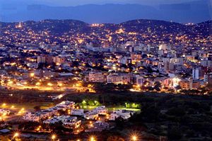
Cúcuta
| Cúcuta | |||
 |
|||
|
|||
| Nickname(s): City without borders | |||
| Motto: More progress! | |||
 |
|||
| Country | Colombia | ||
|---|---|---|---|
| Department | Norte de Santander | ||
| Foundation | June 17, 1733[1] | ||
| Government | |||
| - Mayor | Maria Eugenia Riascos | ||
| Area | |||
| - City | 1,176 km² (454.1 sq mi) | ||
| Elevation | 325 m (1,066 ft) | ||
| Population (2005-2006 Census) [1] | |||
| - City | 918.942 | ||
| - Metro | 1,298,187 | ||
| Website: www.alcaldiadecucuta.gov.co |
|||

Cúcuta (pronounced [ˈkukuta]) is a Colombian city, capital of the North Santander Department and located in the northeast of the country. Due to its proximity to the Colombian-Venezuelan border, Cúcuta is an important commercial center. The city has the constitutional category of Special District[2], conforms the most active international border in South America[3] and it's connected by roads with Bogota, Caracas and Cartagena. Its air terminal, the Camilo Daza International Airport is one of the most traveled the country.
According to the 2005 census it has a population 918,942 inhabitants, which rank it as the 5th largest city in the country. The Metropolitan Area of Cúcuta (conformed by other 6 municipalities) has a population of 1'298.187 inhabitants, having the same position in the conurbations. For several years has had the lowest unemployment rate in the country, which nowadays is 8.6%.[4][5]
It is situated in the Cordillera Oriental in the Andes and is connected with Venezuela through the Pan-American Highway. Its area of 1176 km² represents 5.65% of the department. Its altitude is 320 m above sea level, with an average temperature 28°C and annual average precipitation of 1,041 mm.
The city is bordered to the east by Venezuela and Puerto Santander, to the south by Villa del Rosario, Bochalema, and Los Patios, to the north by Tibú, and to the west by El Zulia and San Cayetano.[6][7]
Contents |
Etymology
The city of Cúcuta was called San José de Guasimales from 1733 to 1793[8], the year in which the name changed to San José de Cúcuta—"San José" (Saint Joseph) denotes the Virgin Mary's husband, and "Cúcuta" means "The House of Goblins", from the language of the Barí indigenous group.[9]
In the city's seal, a legend states, Muy Noble, Valerosa y Leal Villa de San José de Cúcuta ("Very Noble, Valiant and Loyal Village of San José of Cúcuta").[10]
The city has the nicknames "City Without Borders", "Gem of the North," and "City Forest."[11].
History
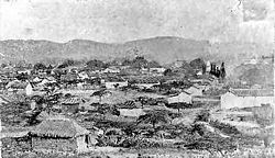
Cúcuta was originally a pre-hispanic settlement. It was entrusted to Sebastian Lorenzo by Pedro de Ursua as an encomienda in 1550. Juana Rangel de Cuellar founded Cúcuta on June 17, 1733, and donated a further 782 hectares. The village, centred on a church, grew considerably due to its strategic commercial location, and eventually became a city.[12]
In city took place important historical events that forged Colombia as an independent republic: one of these events was the Congress of 1821, where the Constitution of Cúcuta was written and approved. This constitution created the Greater Colombia, a big nation conformed by the actual territories of Colombia, Venezuela, Ecuador and Panama. The city conserves all the places where this historical events took place; see Historical Church of Cúcuta, House of Santander and Park of the Great Colombia.
As scenario of the Battle of Cúcuta (February 28, 1813) the city was the beginning of the Admirable Campaign led by Simón Bolívar. This result of this campaign was the independence of Venezuela.
16th Century: First European incursions
The first European who was in the North Santander territories was the German conqueror Ambrosio Alfinger, who in 1530 came from Santa Ana de Coro (Venezuela) with a troops of aventurers and invaded the unexplored eastern region of the newly created Gobernation of Santa Marta.
Alfínger, in search of El Dorado, arrived to the area of indigenous settlements called Tamalameque, along the Magdalena River, where they kept fighting and underwent several tribes, as devastating for the tribe of the nation Chimila. Then followed Giron (Santander), travelled Province of Ocaña from south to north and then returned to the Province of Pamplona to be killed in Chitacomar on the outskirts of the municipality of current Chinácota, by the Indian chimila "Francisquillo" in a battle with the Indians Chimilas and Chitareros. Dead Alfínger, Fedro St. Martin took command of the troops and she returned to Coro passing through the territory of Cucuta.
The 1541 Hernan Perez de Quesada, reached the territory of Chinácota, but had to turn back the same year due to the resistance of indigenous people. Shortly thereafter, Alfonso Perez de Tolosa, left Tocuyo (Venezuela) and went to Salazar de Las Palmas, through Cúcuta, but also had to turn back after losing a lot of soldiers in clashes with the natives.
In 1549 another Spanish troops, commanded by Pedro de Ursúa and Ortún Velasco, invaded the actual territory of North Santander and the same year reached the valleys of Pamplona, where in tribute to the Spanish Pamplona founded a city under the name New Pamplona. The new town soon attracted numerous people by the goodness of climate and the rich gold mines that were discovered in the region. From there came after the expeditions who completed the conquest of the current territory of North Santander.
The first expedition commanded by Diego de Montes, founded the town of Salazar, which soon was destroyed by the Cacique Cínera. In 1583 the town was rebuilt Alonso Esteban Rangel (great-grandfather of the founder of Cucuta) on a site more appropriate for the defense in the event of new attacks by the natives.
The second expedition was commanded by the captain Francisco Fernández de Contreras, who reached to the lands of the Hacaritamas indigenous group, and July 26, 1572 founded the city of Ocaña and called it "Santa Ana de Hacarí", while some of his colleagues the called New Madrid, and other Santa Ana of Ocaña. Antonio Orozco, subaltern of Fernandez, founded the next year, the town of Teorama, while the Friars Augustinians founded a convent in what is today the city of Chinácota.
17th Century: Foundation
|
"A journey through the city centre where the Cathedral of St. Joseph, the Palace of Government and the Monument to the column of Bolivar are located is returning to the historical roots of our ancestors.". |
| — El Espectador |
In the early 16th century a great part of the valleys of Cúcuta belonged to Captain Christopher de Araque Ponce de Leon. The land passed through inheritance to his son Fernando Araque Ponce de Leon, who was owner of the entire territory from the Valley of Cucuta to the village of San Jose; jurisdiction of the city of San Faustino. These fields had been donated to the master Araque by the Governor of the Province of New Merida heading in September 9, 1630.
The constant hostility of the Motilones indigenous group with the whites who lived in the valley and the economic ambitions of them, were key factors to request the erection of a parish with the name "San José" and populate it if they get the license.
Considering that the whites were going to request the erection of a parish and that they had selected Guasimal -along the Pamplonita river- for it, Juana Rangel de Cuéllar donated 782 hectares in June 17, 1783 for the construction of a church and a place for Spanish families were established in what today is the neighbourhood of San Luis.
19th Century: Major events
Battle of Cúcuta

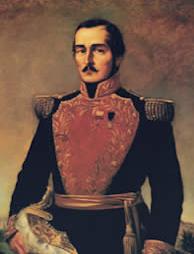
The Battle of Cúcuta was one of the most important events of the 19th century, due it is part of the independence of Colombia and Venezuela. It was the beginning of the Admirable Campaign of Simón Bolívar.[13][14] On February 28 1813, the Libertador captured the city. The battle lasted from 9:00 a.m. until noon; 400 men led by Bolivar fought 800 troops led by the Spanish general Ramon Correa. Two Colombian soldiers were killed and 14 injured; on the opposing side, 20 Spanish forces were killed and 40 injured.[15] The victory gave the independence to the city of Cúcuta and started the Admirable Campaign.[16]
Colonel Simón Bolívar, launched a major offensive against the Spanish forces who were on the east bank of the Magdalena River and quickly achieved resounding victories that carried him to undertake a journey to liberate the Valleys of Cúcuta held by the realistic command of Colonel Ramon Correa.
On February 28, 1813, Correa attended Mass very early in the morning, while Bolivar's troops were mobilized by the western hills overlooking the town of San Jose de Cúcuta. Correa met Bolivar's patriots with over 800 well-equipped men. It was placed a rifle shot away from the hills occupied by insurgents. The battle began. A batch of 100 rifle king's attempts to dominate the right flank of the army Creole, but a rapid change of position left without effect the movement. The fight was bitter and conflicted. During four hours did not favour any of the sides, until the one p.m. a burden on the bayonet sorted by Bolivar's victory gave the Patriots. Correa then began withdrawing toward San Antonio del Tachira and then to La Grita with his troops decimated.
Congress of Cúcuta
On August 30, 1821 took place the Congress of Cúcuta at the town of Villa del Rosario (nowadays part of Cucuta) in one of the most important church of the time, nowadays known as the "Historic Temple of Cúcuta". The congress was established by Antonio Nariño and also participated Francisco de Paula Santander, Simón Bolívar and other important leaders of Spanish America's successful struggle for independence from Spain.
The main objective of this congress was to unify the nations of the New Granada (now Colombia and Panama) and Venezuela by the Constitution of Cucuta and thus create a huge state then known as the Republic of Colombia (now Greater Colombia). Quito subsequently joined the Gran Colombia.
At 11 am on October 3, 1821, the Liberator Simón Bolívar entered in the meeting room located in the sacristy of the church. He was accompanied by a committee of MPs and their staff overall. He took a seat next to the president of Congress, all stood and was sworn in as president of the fledgling Republic of Colombia. Once completed a speech and possession of General Francisco de Paula Santander as vice president of the republic, was read the text of the new Constitution.
Constitution of Cúcuta
Earthquake of Cúcuta
On 18 May 1875, the city was largely destroyed by the earthquake of Cúcuta, also known as the "Earthquake of the Andes", but was soon rebuilt. The earthquake occurred at 11:15 a.m.; it destroyed Villa del Rosario, San Antonio del Tachira and Capacho, seriously damaged the Venezuelan settlements of San Cristóbal, La Mulata, Rubio, Michelena, La Grita and Colón (among others), and was felt in Bogotá and Caracas.
Industrial Revolution

In the 19th century, the construction of a railroad set off an Industrial Revolution in the city. The railroad had four branches: North, East, South and West.[17] The North branch was constructed from 1878 to 1888, and connected Cúcuta with Puerto Santander and Venezuela. Construction of the East branch began in and South branches began in 1878; the South branch linked with Pamplona, Colombia, and ended in El Diamante. The West branch was not built owing to economic problems. The railroad company fell into bankruptcy and was closed in 1960.[18]
The population of the city's metropolitan area was 59,323 in 1939, 532,564 in 1990, and 950,000 in 2005.[19]
Many of the city's historic buildings lie within the Park of Greater Colombia, including the House of Santander, the historic church, and the historic tamarind. All these are well preserved.[20]
Geography, climate and layout
Geography
The city is located in the eastern part of the Department of North Santander, in the Cordillera Oriental, close to the border with Venezuela. The city's area is 1,176 km², or 5.65% of the area of North Santander. The elevation is 320 metres (1,050 ft) above sea-level.
Rivers in Cúcuta and Norte de Santander include the Pamplonita River, Guaramito River, San Miguel River and Zulia River.[21]
The Pamplonita River crosses the Norte de Santander Department.
| Zones
(Comunas) |
Small towns
(Corregimientos) |
Settlements
(Caseríos) |
|---|---|---|
|
|
|
| Maps of Cúcuta | |||
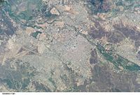 |
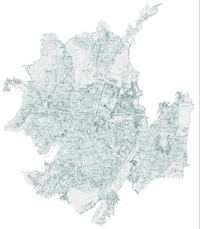 |
||
| Satellite map | Urban map | ||
Climate
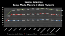
The mean temperature is 28.0 °C; high temperatures are around 35 °C. There is a sharp contrast between the wet season and the dry season. The driest months are December, January, February and March; the wettest are April, May, September, October and November. June and July usually have significant precipitation, whereas August is sunny and windy. The annual precipitation is around 1,041 mm.[22]
| Climate of Cúcuta | |||
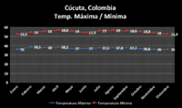 |
 |
||
| Maximum (red) and minimum (blue) temperature of Cúcuta | Medium temperature of Cúcuta | ||
Layout
Cúcuta's streets are organized in a grid layout adopted from Spain in colonial times. Calles (streets) traverse from east to west, perpendicular to the hills, and numbering increases to the north and to the south from Calle 1. Avenidas (avenues) traverse from south to north, parallel to the hills, and numbering increases both east to west, and west to east from a central avenida numbered 0 (Avenida Cero, one of the city's most important avenues). From west to east, avenues are numbered with an E added to their number, as to denote East (este) .
More than 300 neighborhoods form the urban network. Affluent neighborhoods are primarily situated in the north and north-east; poorer ones are in the south and south-east, many of them squatter areas. The middle class lives mostly in the central, west and northwest areas.
Symbols

Flag
The red and black North Santander Department flag was exhibited for the first time in 1928, when the first National Olympics were held in Cali. However, the flag of Cúcuta[23] was not legalized until Mayor Carlos A. Rangel issued Decree 106 on May 3, 1988.
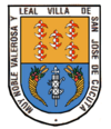
Seal
The shield of Cúcuta[23] was adopted in 1958 by Decree 032 on February 3, 1958, after a request by the History Academy of North Santander. The shield is a classic shape, and carries the title conferred to the city by Royal Decree of the Emperor Carlos IV: Very noble, valiant and loyal Village of San José of Cúcuta.
The upper part depicts the weapons of the city's founder Juana Rangel of Cuéllar, who donated lands for the foundation of the city on June 17, 1733. They are five silver and red fleur-de-lis in the shape of reels, on a golden background.
The lower part of the shield displays the weapons that the National Congress adopted for Colombia by the Law of October 6, 1821, at its meeting in the Villa del Rosario. In the center are a quiver of spears, marked with X's, and a set of bow and arrows, tied with tricolor tape. The spears represent attributes of the Roman consuls; the X is a symbol of the right of life or death; the bow and arrows are symbols of the Hispanic Indu race.
Anthem
The Anthem of Cúcuta[23] was legalized by means of Decree 039 of February 8, 1984, by Mayor Luis Vicente Mountain Forest. The lyrics were written by Dr. Manuel Orillo Martínez, and the music by the master Pablo Tarazona Prada. It was chosen as the Anthem of Cúcuta by a unanimous vote in a contest held in the Theater Zulima.
Demographics
Population
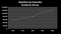
Cúcuta has undergone a large demographic growth, having 387,481 inhabitants in 1951 and now, 1,196,775. It is the sixth most populous city in Colombia. The metropolitan area, which includes the municipalities of Villa del Rosario, Los Patios, El Zulia, San Cayetano and Puerto Santander, has a combined population of more than 1.1 million people. It is the largest metropolitan area in eastern Colombia and sixth in Colombia behind Barranquilla and Cartagena.
As of the census of 2005, there were 1,196,755 people and 187,041 households in the city. The population density was 2,000/km², making Cúcuta one of the more densely-populated cities in the east of the country.
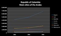
| Population of Cúcuta | |||
 |
 |
||
| Population of Cúcuta 1964–2006 | Población of main cities of the Andes | ||
People
Many notable Colombians are from Cúcuta:
- Francisco de Paula Santander, the first President of Colombia, known as "the man of the laws".
- Virgilio Barco, a former president of Colombia.
- Fabiola Zuluaga, the most successful Colombian tennis player[24]
- Actors such as Lincoln Palomeque, Endry Carreño, Rafael García Herreros (the founder of Minuto de Dios)
- Elias M. Soto, a classic musician.
- Marino Vargas Villalta, civic leader and businessman. During the fifities and sixties, he was also the president of the popular and successful local soccer team, the Cúcuta Deportivo.
- Alberto Villamizar, a former congressman and ambassador to Indonesia, The Netherlands and Cuba, Colombia's first kidnappings czar and leading political figure of the Nuevo liberalismo (New Liberalism) movement of Luis Carlos Galan.
Government

As of 2006, the mayor of Cúcuta is Ramiro Suárez Corzo, who has occupied the position since January 2004 (elected by a majority of 62.06%). He represents the movement Colombia Viva.
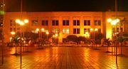
Cúcuta is the capital of Norte de Santander Department, and houses the Department Hall and the City Hall of the Metropolitan Area of Cúcuta along with the Francisco de Paula Santander Justice Palace. The Principal Mayor and Urban Council, both elected by popular vote, are responsible for city administration.
The city divided into 10 localities (comunas). The Metropolitan Area of Cúcuta is formed by Cúcuta (as the main city), Villa del Rosario, Los Patios, San Cayetano, El Zulia and Puerto Santander.
Politics in Cúcuta are not defined by a single political movement. Past rivals included the Partido Liberal Colombiano and the Colombian Conservative Party. Today the political landscape is shared by many political parties, none commanding majority support.
Economy
The economy of Cúcuta is the sixth largest of the country, preceded by cities like:Cartagena ,Barranquilla, Cali,Medellín, and Bogotá. The Cúcuta's economy is based primarily in the industry and agriculture. The "zone franca"is the more active of Colombia,To the being Venezuela the second commercial partner of Colombia. The industry of the city is based in the Mining industry, the production of milk,and the industry of the cement and materials of construction.
US–Colombia Free Trade Agreement implications for Cúcuta
Colombia signed a Free Trade Agreement with the United States amidst opposition by Venezuela. Despite this opposition, industries from Venezuela are constructing their infrastructure in Cúcuta to export their products to the United States, registering their products as if they were Colombian, a strategy that would allow them to export without paying certain tariffs. For that reason, Cúcuta is expected to become an industrial city.[25]
Colombian law provides tax exemptions for Venezuelan imports through the Zona Franca, which, coupled with the motorway links between Cúcuta and Maracaibo, increases the possibility of exports from Maracaibo into Colombia.[26]
Telecommunications
The city's telecommunications services include payphones, WiMAX wireless networks,[27] and mobile phone networks (GSM, CDMA and TDMA).
Telecom Colombia offers the service of local, national and international telephony and broadband ADSL Internet. There are three mobile telephony operators: Comcel, Movistar and Tigo.
Transport
Public transportation in the Metropolitan Area of Cúcuta includes the Metrobus system.
For travel outside the city, there is a bus station called "Terminal de Transportes" (to be replaced by a new one), the Camilo Daza International Airport (Colombia) and the San Antonio Airport (Venezuela). Eighty years ago the city had the "Railroad of Cúcuta", which connected with Venezuela.
The highway to Bucaramanga (renovated in January 2007)[28] connects Cúcuta with Bogotá, Medellín and Cali. The highway to Ocaña connects the city with Barranquilla, Cartagena and Santa Marta; the highway to San Cristóbal with Caracas.
Distances to other cities
|
Cities of Colombia
|
Cities of Venezuela
|
Bridges

The city has many bridges:
- San Rafael Bridge – official name is "Benito Hernández Bustos".
- Francisco de Paula Andrade Troconis Bridge – the prolongation of the Av. 0, connecting the city with the municipality of Los Patios.
- Elías M. Soto Bridge – rebuilt and extended to 6 rails.
- San Luís Bridge – imported from England.
- Rafael García Herreros Bridge – part of the East Anilo Vial.
Six overpasses are under construction.
Education
The basic education and the high school education are in Colombian "Calendary A" for schools (from February to November).
Schools
- Colegio Calasanz
- Colegio Sagrado Corazón de Jesús
- Colegio Instituto Técnico Nacional de Comercio
- Colegio Salesiano
- Colegio La Salle
- Colegio Santo Angel de la Guarda
- Colegio Santa Teresa
- Colegio Los Almendros
- Colegio Carmen Teresiano
- Colegio Cardenal Sancha
Universities
State Universities
- Universidad Francisco de Paula Santander
- Universidad de Pamplona
Private Universities
- Universidad Libre de Colombia
- Universidad de Santander
- Universidad Antonio Nariño
- Universidad Simón Bolivar
Recent development

The city has recently undergone development at an historically unprecedented rate. This has included construction of six overpasses, a convention center, a new bus terminal, a new Integrated Massive Transportation System called Metrobus, modernization of state owned schools, renewal of downtown, and doubling the capacity of the General Santander Stadium.
New industries are expected to come from Venezuela, which will place their factories in Cúcuta to export through the Colombia Trade Promotion Agreement between Colombia and the United States.[19]
Landscape
Monuments
The main monuments in the city are:
- The monument of the Battle of Cúcuta
- The monument of Juana Rangel de Cuellar, the founder of Cúcuta
- The monument of Camilo Daza, located in the Camilo Daza International Airport.

Parks
The main parks in the city are:
- Santander Park (in Spanish, Parque Santander), the main park of the city located in front of the city hall.
- Colón Park (in Spanish, Parkque Colón), constructed in honor of Cristobal Columbus (in Spanish, Cristobal Colón).
- Simón Bolivar Park (in Spanish, Parque Simón Bolivar), constructed in honor of Simón Bolivar and donated by the Consulate of Venezuela in Cúcuta.
Greenery

From its founding, residents have valued Cúcuta's trees.
Cúcuta has more green zones than many other cities in Colombia. Some consider it an urban lung, due to its many trees and lack of pollution. The greenery is thanks to gifts by prominent Cucuteños, and the legion of foreigners who reconstructed the city after the 1875 earthquake, led by engineer Francisco de Paula Andrade Troconis. The first planted trees were clemones. Soon they were replaced by acacias, peracos and almond trees that adorned the parks and roadsides. An example of this city design is the Avenue of the Lights (based on oití, ficus and cují), that forms a natural tunnel admired in the rest of the country and by tourists.
Palm trees are common in places such as Santander Park, Great Colombian Park, the Bank of the Republic and the Department Hall of Norte de Santander.
The official flower of Cúcuta is the Isora.

References
- ↑ "Cities and towns foundations". Luis Ángel Arango Library. Retrieved on 2008-01-07.
- ↑ "Constitution of 1991 - Legislative Act N° 2 - July 6, 2007" (PDF). Presidence of the Republic of Colombia. Retrieved on 2008-01-07.
- ↑ "Characterizing the Colombo-Venezuelan border". Andean Comunity of Nations. Retrieved on 2008-01-07.
- ↑ "En 0,2% aumentó desempleo en Colombia en septiembre, respecto a hace un año." (HTML). Portafolio. Retrieved on 2008-11-11.
- ↑ "El desempleo sigue en 11,2%, según el Dane." (HTML). El Espectador. Retrieved on 2008-11-11.
- ↑ "Borders of Cúcuta". Chamber of Commerce of Cúcuta. Retrieved on 2008-01-07.
- ↑ "Map of Cúcuta". CúcutaNuestra.com. Retrieved on 2008-01-07.
- ↑ "Cúcuta". Enciclopedia Britannica. Retrieved on 2008-01-07.
- ↑ "The city - Geographical data". Chamber of Commerce of Cúcuta. Retrieved on 2008-01-07.
- ↑ "Seal of Cúcuta". Rincón del Vago. Retrieved on 2008-01-07.
- ↑ "Cúcuta is declared green municipality". La Opinión. Retrieved on 2008-01-07.
- ↑ "San José de Cúcuta". Norte de Santander.
- ↑ "Admirable Campaign". Polar Foundation. Retrieved on 2008-02-07.
- ↑ "Admirable Campaign". Polar Foundation. Retrieved on 2008-02-07.
- ↑ "Admirable Campaign". Simón-Bolívar.org. Retrieved on 2008-02-07.
- ↑ "Campaña Admirable". Retrieved on 2006-02-11. (Spanish)
- ↑ "Ferrocarril de Cúcuta". Biblioteca Luis Ángel Arango. Retrieved on 2007-02-11.
- ↑ "Especial 45 años". Diario La Opinión. Retrieved on 2007-02-11.
- ↑ 19.0 19.1 "Colombia. Proyecciones de población, por área, según municipios" (Excel spreadsheet). Departmento Administrativo Nacional De Estadistica (DANE). Retrieved on 2006-10-15. (Spanish)
- ↑ "Centro Histórico Villa del Rosario". Ministerio de Cultura de Colombia.
- ↑ Ministerio del Medio Ambiente. "Colombia; Rio de Cucuta". Retrieved on 2006-10-15. (Spanish)
- ↑ Chamber of Commerce of Cúcuta. "Geographical Data". Retrieved on 2007-02-13. (Spanish)
- ↑ 23.0 23.1 23.2 "Símbolos de Cúcuta". CúcutaNuestra.com. Retrieved on 2008-01-07.
- ↑ Azapedia: Fabiola Zuluaga (Spanish) asapedia.com Accessed 15 October 2006
- ↑ COLFTA. "Cúcuta quiere sacarle jugo al TLC". Retrieved on 2006-10-15. (Spanish)
- ↑ ANDI. "ANDI Zona Franca". Retrieved on 2006-10-15. (Spanish)
- ↑ Peña, Javier (2006-10-27). "Masificarán Internet Inalámbrico en Cúcuta" (in Spanish), CucutaNuestra.com. Retrieved on 2007-02-19.
- ↑ Peña, Javier (2006-10-31). "Avanza Plan 2500" (in Spanish), CucutaNuestra.com. Retrieved on 2007-02-19.
External links
Government
- (Spanish) City Hall of Cúcuta
- (Spanish) Gobernación de Norte de Santander
- (Spanish) Education Secretary of North Santander
Health
Mass media
- (Spanish) Newspaper La Opinion
- (Spanish) Asi Es Cucuta - Noticias de Cucuta
- (Spanish) Cúcuta Nuestra
- (Spanish) EnCúcuta
- (Spanish) Cúcuta Linda
Universities
- (Spanish) Universidad Francisco de Paula Santander
- (Spanish) Universidad de Santander
- (Spanish) Universidad Simón Bolívar
- (Spanish) Universidad de Pamplona
- (Spanish) Universidad Antonio Nariño
|
|||||||