County Wexford
| County Wexford Contae Loch Garman |
||
| Exemplar Hiberniae | ||
|---|---|---|
| Location | ||
|
||
| Statistics | ||
| Province: | Leinster | |
| County seat: | Wexford | |
| Code: | WX | |
| Area: | 2,353.19 km² (908.54 mi²) 236,549.80 Hectares (584,521 acres)[1] |
|
|
Population (2006) |
131,749[2] | |
| Website: www.wexford.ie | ||
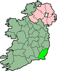
County Wexford (Irish: Contae Loch Garman) is a maritime county in the southeast of Ireland, in the province of Leinster. It takes its name from the principal town, Wexford, founded by Vikings and named by them 'Waesfjord', meaning 'inlet or bay (fjord) of the mud-flats' in the Old Norse language.[3][4] In pre-Norman times it was part of the Kingdom of Uí Cheinnsealaig, whose capital was at Ferns.[5][6] The county's total area (including inland fresh-water areas) is 2,353.19 km² (908.54 mi²).[1] In 2006 the county had a total population of 131,749 people.
Contents |
History

The county is rich in evidence of early human habitation.[7] Portal tombs (sometimes called dolmens) exist at Ballybrittas (on Bree Hill)[8] and at Newbawn[9] — and date from the Neolithic period or earlier. Remains from the Bronze Age period are far more widespread.[7] Early Irish tribes formed the Kingdom of Uí Cheinnsealaig, an area that was slightly larger than the current County Wexford. The county was one of the earliest areas of Ireland to be Christianised, in the early 5th century. Later, from 819 onwards, the Vikings plundered many Christian sites in the county.[10] Wexford town became a Viking settlement near the end of the 9th century.[10]
Wexford was the site of an the invasion of Ireland by Normans in 1169 at the behest of Diarmuid Mac Murrough, King of Uí Cheinnsealaig and king of Leinster (Laigin), which led to the subsequent colonisation of the country by the Anglo-Normans.


The native Irish began to regain some of their former territories in the 14th century, especially in the north of the county, principally under Art MacMurrough Kavanagh.
Under Henry VIII the great religious houses were dissolved, 1536-41 - in Co. Wexford this included Glascarrig Priory, Clonmines Priory, Tintern Abbey, and Dunbrody Abbey.
On 23 October 1641, a major rebellion broke out in Ireland, and Co. Wexford produced strong support for Confederate Ireland. Oliver Cromwell and his English Parliamentarian Army arrived 1649 in the county and captured it. The lands of the Irish and Anglo-Normans were confiscated and given to Cromwell's soldiers as payment for their service in the Parliamentarian Army. At Duncannon, in the south-west of the county, James II, after his defeat at the Battle of the Boyne, embarked for Kinsale and then to exile in France.
Co. Wexford was the most important area in which the 1798 rebellion was fought, during which significant battles occurred at Vinegar Hill (Enniscorthy) and New Ross. The famous ballad Boolavogue was written in remembrance of the Wexford Rising.
At Easter 1916, a small rebellion occurred at Enniscorthy town, on cue with that in Dublin.[11] During World War II, German planes bombed Campile.[12][13] In 1963 John F. Kennedy, then President of the United States, visited the county and his ancestral home at Dunganstown, near New Ross.
Transport


Rail
The Rosslare - Dublin railway line runs through the county, serving Rosslare Europort, Rosslare Strand, Wexford, Enniscorthy and Gorey. Three trains run in each direction daily, with additional commuter services from Gorey.
The Rosslare - Limerick railway line runs through the southern part of the county, serving Bridgetown, Wellington Bridge, Ballycullane and Campile.
Bus
Rosslare and Dublin are also linked by Bus Éireann route 2 [3], while route 5 operates Waterford-New Ross-Enniscorthy-Dublin [4].
Ferry services
Rosslare Europort, located at Rosslare Harbour, operates a busy Ferry service - there are regular sailings to Wales (Pembroke and Fishguard) and France (Cherbourg, Roscoff and Le Havre) for passengers and vehicles.
There is also ferry service in operation between Ballyhack and Passage East (Co. Waterford), crossing the Barrow estuary.
Roads
Recent years have seen a major upgrading of the county's main roads.
Politics
Wexford is a 5-seat constituency - returning 5 Teachta Dála (TD's) to Dáil Éireann.
The current TD's representing the constituency are:
- John Browne (Fianna Fáil Party).
- Seán Connick (Fianna Fáil Party).
- Paul Kehoe (Fine Gael Party).
- Michael D'Arcy (Fine Gael Party)
- Brendan Howlin (Labour Party)
There is also a County Council and the larger towns each have individual town councils.
Media
The local radio station is called South East Radio. [14]
The county's main newspapers include the Wexford People, the New Ross Standard, the Gorey Guardian, and the Enniscorthy Echo.
Damien Tiernan is currently RTÉ's South-East correspondent.
Geography
Location
The county is located in the south-east corner of the island of Ireland. It is bounded by the sea on two sides - on the south by the Atlantic Ocean and on the east by St. George's Channel and the Irish Sea. The River Barrow forms its western boundary. The Blackstairs Mountains form part of the boundary to the north, as do the southern edges of the Wicklow Mountains. The adjoining counties are Waterford, Kilkenny, Carlow and Wicklow.
Demographics
| Year | 1841 | 1851 | 1861 | 1871 | 1881 | 1891 | 1901 | 1911 | 1926 | 1936 | 1946 | 1951 |
|---|---|---|---|---|---|---|---|---|---|---|---|---|
| Population | 202,033 | 180,158 | 143,954 | 132,666 | 123,854 | 111,778 | 104,104 | 102,273 | 95,848 | 94,245 | 91,855 | 90,032 |
| Year | 1956 | 1961 | 1966 | 1971 | 1979 | 1981 | 1986 | 1991 | 1996 | 2002 | 2006 | |||
|---|---|---|---|---|---|---|---|---|---|---|---|---|---|---|
| Population | 87,259 | 83,308 | 83,437 | 86,351 | 96,421 | 99,081 | 102,552 | 102,069 | 104,371 | 116,596 | 131,749 | |||
| Source: Census 2006 — Volume 1, p. 16.PDF (4.22 MB) – Central Statistics Office (Ireland). Retrieved on 2008-06-10. | ||||||||||||||

As stated above, in 2006 the county had a total population of 131,749 people. Of these, 65.4% (86,137 people) lived in rural areas and 34.6% (45,612 people) lived in urban areas.[15]
In 2006, 35.5% of the county's population (46,768 people) were aged under 25 years and 11.6% of its population (15,324 people) were aged over 65 years.[16]
Also in 2006, 89.8% of the county's population stated their religion as Roman Catholic, almost 4% as Church of Ireland (including Protestant) and 3% stated they had no religion. Other religions, small in numbers, made up the remainder.[17]
Between 2002 and 2006, the population of County Wexford increased by 13% (15,153 people).[18]
There has been an influx of migrants in recent years, mainly from other European countries.
Towns and villages


By Population the largest town is Wexford, followed by Enniscorthy, New Ross, Gorey and Bunclody.[19]
- Adamstown, Arthurstown
- Ballycanew, Ballycullane, Ballyedmond, Ballygarrett, Ballyhack, Ballymitty, Ballywilliam, Bannow, Blackwater, Bree, Bridgetown, Broadway, Bunclody
- Camolin, Campile, Castlebridge, Castletown, Cleariestown, Clohamon, Clonroche, Coolgreany, Courtown, Craanford, Crossabeg, Cullenstown, Curracloe
- Duncannon, Duncormick
- Enniscorthy
- Ferns, Fethard-on-Sea, Foulkesmill
- Gorey
- Hollyfort
- Inch
- Kilanerin, Kilmore, Kilmore Quay, Kilmuckridge, Kiltealy
- Monamolin, Monaseed, Murrintown, Monageer
- Newbawn
- New Ross
- Oulart, Oylegate
- Poulpeasty
- Rathangan, Rosslare, Rosslare Harbour, Raheen, Rathnure
- Saltmills
- Taghmon
- Watch House Village, Wellingtonbridge, Wexford
Principal port:
- Rosslare Europort
Physical geography
Climate
| for Rosslare | |||||||||||||||||||||||||||||||||||||||||||||||
|---|---|---|---|---|---|---|---|---|---|---|---|---|---|---|---|---|---|---|---|---|---|---|---|---|---|---|---|---|---|---|---|---|---|---|---|---|---|---|---|---|---|---|---|---|---|---|---|
| J | F | M | A | M | J | J | A | S | O | N | D | ||||||||||||||||||||||||||||||||||||
|
95
8
4
|
70
8
4
|
68
9
4
|
56
11
6
|
56
13
8
|
51
16
10
|
51
18
12
|
69
18
12
|
73
16
11
|
95
14
9
|
97
11
6
|
98
9
5
|
||||||||||||||||||||||||||||||||||||
| temperatures in °C precipitation totals in mm source: Rosslare Met. Station Avg. (1961—90) |
|||||||||||||||||||||||||||||||||||||||||||||||
|
Imperial conversion
|
|||||||||||||||||||||||||||||||||||||||||||||||
Co. Wexford is known as Ireland's "sunny southeast" because of the high amount of sunshine it receives relative to the rest of Ireland — in general, the number of hours of sunshine received daily is higher.
Overall, the county has a mild, but changeable, oceanic climate with few extremes. The North Atlantic Drift, a continuation of the Gulf Stream, moderates winter temperatures. There is a meteorological station located at Rosslare Harbour.[20]
Temperature: January and February are generally the coldest months, with temperatures ranging between 4 - 8 °C on average.[21] July and August are generally the warmest months, with temperatures ranging between 12 - 18 °C on average.[21]
Wind: The prevailing winds are from the south-west.[22]
Precipitation: Precipitation falls throughout the year - Mean Annual Rainfall is between 800-1200 mm.[23] Generally, the county receives less snow than more northerly parts of Ireland. Serious snowfalls are relatively rare, but can occur. The one exception is Mount Leinster, visible from a large portion of the county, which is frequently covered with snow during the winter months.
Frost is frequent is winter months. However, fewer days of frost occur in coastal areas.
Mountains and hills
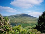
Largely low-lying fertile land is the characteristic landscape of the county. The highest point in the county is Mount Leinster (795 m,[24] 2610 ft) in the Blackstairs Mountains in the north-west on the boundary with Co. Carlow.
Other high points are:
- Black Rock Mountain, which is 599 m (1,965 ft) high. It is located near the Wexford-Carlow border, within Co. Wexford.
- Croghan Mountain (or Croghan Kinsella) on the Wexford-Wicklow border - 606 m (1,988 ft) high.
- Annagh Hill 454 m (1,490 ft), near the Wicklow border.
- Slieveboy at 420 m (1,378 ft) high.
Notable hills include: Carrigbyrne Hill, Camross (or Camaross) Hill (181 m),[25] Carrigmaistia (167 m),[25] Bree Hill (179 m),[25] Gibbet Hill, Vinegar Hill, Slievecoiltia and Forth Mountain (237 m),[25] and Tara Hill.
Rivers and lakes

The major rivers are the Slaney and the Barrow.
At 192 km (119.5 miles) in length, the river Barrow is the second longest river on the island of Ireland.[26]
Other smaller rivers of note are the Owenduff, Pollmounty, Corrock, Urrin, Boro, Owenavorragh, Sow and Bann rivers.
There is no significant fresh-water lake in the county. Small seaside lakes or lagoons exist at two locations – one is called Lady's Island Lake and the other Tacumshin Lake.
Islands
The Saltee Islands, located off Wexford's south coast, are the only major islands in the county. They consist of two main islands - Great Saltee and Little Saltee. Two small rocks, known as Coningmore and Coningbeg, lie roughly south-west of these islands.

Bannow Island, approx. 1.6 km (1 mile) in length, lies just inside the entrance of Bannow Bay. This is the island where the Normans first landed in Ireland in 1169. Since then the island has become attached to the mainland due to the process of silting and is no longer an island. Today, there is also a roadway between the former island and the mainland.
In Lady's Island Bay are two small islets - Inish and Lady's Island.
In Tacumshin Lake there are two small islets named the Sigginstown Islands - Little and Great.
West of Ballyteige Bay are the two Keeragh Islands (or islets), a rocky reef.
About 8 km east of Greenore Point is Tuskar Rock - on which sits Tuskar Lighthouse.
Human geography
Political geography
The county is one of 12 counties located within the province of Leinster, part of the 26-county Republic of Ireland, part of the island of Ireland.
The main Political subdivisions are the Barony, Civil Parish and Townland.
There are ten baronies within the county. They are Gorey, Scarawalsh, Ballaghkeen North, Ballaghkeen South, Shelmaliere East, Shelmaliere West, Bantry, Shelburne, Bargy and Forth. The barony is based on pre-Norman Gaelic tribal areas and is now little used.
Co. Wexford contains 134 Civil Parishes.
Civil Parishes are subdivided into townlands. The townland is the smallest division and is unique to Ireland and Scotland. The townland is a division often utilised on a day-to-day basis.
Agriculture
The economy is chiefly agricultural. Cattle, sheep, pig rearing and some horse breeding are the main types of husbandry practiced. Poultry rearing, once popular, has very much declined. Wheat, barley, rapeseed, and oats are grown, as are potatoes. Sugar beet is no longer grown due to the withdrawal of EU subsidies. The numbers involved in farming have been declining for many years and many of the seasonal workers are now eastern Europeans. Mushrooms are also grown indoors. Tomatoes are grown under glass, for example at Campile. Wexford strawberries are famous and can be bought in shops and wayside stalls throughout the summer. Every year, near the end of June, a 'Strawberry Fair' Festival takes place in the town of Enniscorthy - and a Strawberry Queen is crowned. Dairy farming forms an important part of the agricultural industry. Locally produced milk is on sale in many supermarkets. Wexford Irish Cheddar is an award-winning brand, and Carrigbyrne, a full-flavoured soft cheese, is produced near New Ross.
Fishing

Much maritime activity takes place - especially at Kilmore Quay and Slade, but also on a smaller scale at many other locations.
Common fish species include herring, mackerel, cod, monkfish, whiting, bass, perch, gurnard, haddock, mullet, pollock, John Dory, sole, conger eel, shad, salmon, trout, pike, carp, and tench.
Shellfish include mussels, cockles, periwinkles, clams, and oysters.
Forestry
Evergreen tree species are extensively cultivated, especially in more recent years - Norway Spruce and Sitka Spruce are the most common varieties planted. These are generally sown on poorer quality soils (mainly in bogs and on hills or mountainsides). A small amount of deciduous trees are also planted, though these require better soils.
Also see Flora (below).
Sport
Gaelic games
GAA is very popular in the county, which is noted most for hurling. Wexford last won the All-Ireland Senior Hurling Championship in 1996, beating County Limerick in the final. However, there has been a rapid decline since then in terms of success. In recent years the county Football team has been making rapid advances. Camogie, a women's version of hurling, is also played, and Wexford won the All Ireland in 2007. Wexford Park is the county's main GAA pitch. Also, handball is played on a limited basis; there are a number of handball alleys located throughout the county.
Soccer
Wexford Youths F.C., recently formed, is the major soccer club in the county.
Golf
There are numerous golf clubs in the county - including Rosslare (a Links course), [27] and Enniscorthy.[28] Two more are located near Gorey - Ballymoney Golf Club and Courtown Golf Club - both 18 hole courses. [29] There are also a few others. New Ross Golf Club, however, is actually located in County Kilkenny - about 1 km from New Ross town.[30]
There are also many par-3 courses in the county, such as Scarke Golf Course & Driving Range, [31] located about 2 km east of New Ross town, the 'Abbey Par 3' course, at Winningtown, Fethard-on-Sea, Blackwater Par 3 Golf Course,[32] Kilnew, Blackwater, located a few kilometres northeast of Wexford town, Garrylough Golf Course and Driving Range, Screen, and Rathaspeck Manor Golf Course, Rathaspeck, near Rosslare (there are also few Par-4 holes on this course). There are also a number of other Par-3 courses in the county.
Other sports
Wexford Racecourse (horse racing) is located at Wexford town [33] and there is a Greyhound Racing track at Enniscorthy. [34]
Angling is also popular.
A range of other sports are also played and pursued.
Energy

Carnsore Point made the national headlines in the late 1970s after a proposal was made to build a nuclear energy plant there; the plans were abandoned after extensive protests from the public, due to environmental and health concerns.[35] A wind farm has now been built on the site, featuring 14 wind turbines generating electricity. It was completed in November 2002 and was the first wind farm on the east coast of Ireland. Wind farms now exist at a few other locations in the county, such as Ballywater Wind Farm, at Cahore (near Kilmuckridge), on the county's east coast, and Richfield wind farm (located in the southeast of the county), are other examples.
Great Island Power Station, operated by the Electricity Supply Board (ESB), opened in 1967. It is an electricity-generating station that is fueled by oil. It is located at the confluence of the rivers Barrow and Suir, near Campile. The station was scheduled to close by 2010.[36] [37] However, it was announced in early August 2008 that the Station has been sold to a foreign company. It will now probably remain open, though its future still remains uncertain.[38]
Geology
Bedrock
The Blackstairs mountain range consists of Caledonian granite. Silurian rocks cover almost the rest of the entire county – these are sedimentary bedrocks of almost entirely marine origin (shales and mudstones, marls and limestones, sandstones and grits).
According to the Geological Survey of Ireland (GSI),
“The bulk of the geology of the county comprises Ordovician slates and volcanics dating back to a vanished ocean bed, which was approximately 450 million year old. Overlying the Ordovician there is a succession of Devonian sandstones (ORS Old Red Sandstones) passing up into Carboniferous Limestones and up into the Permo-Trias rocks.” [39]
and,
“the most common rock types in Co. Wexford are:
- 1. Slates (1630 km² or 69% of the county) Cambrian and Ordovician.
- 2. Greywacke, sandstone and quartzite (348 km² or 15% of the county).” [39]
Some of the oldest rocks in Ireland are found near Rosslare in the southeast of the county - the Greenore Point and Kilmore Quay Groups are older than 620 million years.[39]
Hook Head is noted for the many fossils that occur in the Carboniferous limestones located there. [39] It is also noted for its Red Sandstone, quarried there in the past.
A series of volcanic rocks are located in the county, at Carrigbyrne Hill, Camross Hill, Bree Hill and Vinegar Hill. They are said to be of Ordovician age (dating from approximately 430 million years ago). These volcanic rocks are said to have emerged from small underwater volcanoes pushing molten material up to the surface which solidified to form hard rocks that have resisted breakdown by weathering agents to the present day. Of course, these volcanoes are long since extinct, like those elsewhere in the country. With the absence of any major fault lines, this region, like the rest of Ireland, does not experience earthquakes or tremors of any significance.
Soils
Most, but not all, of the county was covered with the Ice Sheet during the last Ice Age. As the ice retreated, Co. Wexford would have been one of the first areas to be covered with glacial drift - a mixture of boulders, clay, sand and gravel - that blanketed the existing bedrock. This has led to high quality soils, suitable for a wide range of agriculture.
A very detailed soil survey of the county was published in 1964, as part of the 'National Soil Survey of Ireland'. It contains a useful soil map of Co. Wexford. It classifies each area of the county according to its specific soil type. [40]
Most of the county is covered with soil called Brown Earths, described as well-drained and having a wide use range. After that, Gleys (poorly to imperfectly drained with a limited use range) are the next major soil type, primarily located in the south-east of the county and east of Gorey (along the coast). Gleys are dotted elsewhere around the county in small areas, and where they occur they generally form bogland. The last major soil type is Brown Podzolics (well drained with a fairly limited use range) - located mainly near the edges of the Blackstairs Mountain range and around Bunclody and in the baronies of East Shelmalier and South Ballaghkeen.
Though there are areas covered with other soil types, these are of limited extent.
Mining
Silver was once mined at Clonmines - primarily in Tudor times. Lead was mined at Caim, 1818-c1850 - this mine also contains zinc; the two are usually found together. Copper ore (Malachite) is found at Kerloge, just south of the town of Wexford. Iron is found in small quantities at Courtown Harbour. The county is not noted for mineral reserves. No significant mining activity is currently practised, with the exception of quarrying for stone.
There is one exception. In 2007, a significant oil find was made 60 kilometres off Hook Head in Co Wexford. [41]
Wildlife
Flora
Common species of tree include oak, ash, sycamore, alder, blackthorn, hawthorn, beech and birch. Less common (but plentiful) are wild cherry and Scots pine (also called Red Deal). Elm is now far less common, due to the devastating effects of Dutch elm disease. Gorse (or furze) is very common.
There is very little natural forest in the county. Most natural trees and vegetation grow on hedgerows.
Fauna
South-eastern Wexford is an important site for wild birds - the north side of Wexford Harbour, the North Slob, is home to 10,000 Greenland White-Fronted Geese each winter (roughly one third of the entire world's population), while in the summer Lady's Island Lake is an important breeding site for terns, especially the Roseate Tern. Grey heron is also seen.
Throughout the county pheasant, wood pigeon and feral pigeons are widespread. Swans, wild duck, kingfisher, and owls (the long-eared owl, the short-eared owl, and the barn owl) are less common - but plentiful. Red grouse, once common, are now extremely scarce. The species has been in decline for some decades. Threats include habitat degradation, disease, predation and over-hunting. Red grouse in Ireland are now considered threatened. [42] The corncrake, also once very common, is now almost never seen. Smaller birds - such as crows, swallows, robins, wrens and so on - are very common. The first magpies in Ireland were recorded by Robert Leigh, of Rosegarland, Co. Wexford, as having appeared in the County of Wexford about 1676. [43] [44]
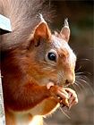
Land mammals include badger, rabbit, otter, hedgehog, red fox, mink, bats, squirrel (red and grey squirrel). Rat (brown and black), (It is nearly always the brown rat that is seen; however, the black rat is also occasionally seen in Co. Wexford. Neither is native to Ireland) and mice (the wood (or field) mouse and house mouse). Two types of hare - the Irish (or mountain) hare and the less common brown (or European) hare - are found. Hare is not nearly as common as Rabbit. The stoat (Mustela erminea hibernica) is also reasonably common. Locally the stoat is just as often incorrectly called a weasel.
Only two types of seal are found on Co. Wexford's coast - Atlantic grey seals are very plentiful in coastal areas, but the slightly smaller common (or harbour) seal is less common, yet plentiful.
The Small Tortoiseshell butterfly (reddish-orange colour, with black markings) is the most common species of butterfly in the county. Various types of moth are also common. The common frog is plentiful, and is the only type of frog found.
Extinct species include the Irish elk (or Giant Irish Deer) and the Irish wolf. Some evidence suggests wolves became extinct in Co. Wexford in the 1730s.
Arts
Wexford Festival Opera

Since 1951, an opera festival — Wexford Festival Opera — takes place every year in the Theatre Royal in Wexford town and runs for several weeks.[45] A new Opera House has recently replaced the old one on the same site, but it us still called the Theatre Royal — the new theatre opened in 2008 .
Singing tradition
There is a renowned singing tradition in County Wexford. Having an abundance of traditional songs, many of which relate to the rebellion of 1798, the county has for many years had a strong presence in the Irish traditional singing scene. Noted singers include All-Ireland Fleadh Champions Paddy Berry, Seamus Brogan and Niall Wall. Paddy Berry has also collected and published a number of songs from Wexford.
Cinema
Beaches in Curracloe, Co. Wexford were used to film the opening scenes of the movie Saving Private Ryan, which depicted the D-day assault on Omaha Beach.
The Count of Monte Cristo, directed by Kevin Reynolds, was partly filmed in the village of Duncannon in 2000 — Duncannon Fort being used for one of the main scenes.[46]
Public libraries
There are public libraries located at Wexford, Gorey, Enniscorthy, New Ross and Bunclody.[47] The Library service hosts many literary activities, featuring such famous guest speakers such as Séamus Heaney, Roger McGough, John Banville, Claire Keegan and John Montague.
Health
Wexford General Hospital is located in Wexford town. It has a Accident and Emergency department. Wexford General Hospital also provides the following services – Medicine, General Surgery, Gynaecology, Obstetrics, Pediatrics.[48]
St Senan's psychiatric hospital is located on the edge of Enniscorthy town.[49] St John's Hospital in Enniscorthy and New Houghton Hospital in New Ross provide services for the elderly while Gorey also has a District Hospital.
Places of interest
The scenic Bannow Drive, popular amongst tourists, is a signposted route through four Wexford villages: Duncormick, Cullenstown, Bannow and Wellingtonbridge.
Ballyteigue Burrow, located by Duncormick, is one the finest protected sand dune systems in Ireland. Rich in wild flowers, wildlife and butterflies, this 9 km coastal stretch is a protected nature reserve by the golden sands of Ballyteigue Bay, with spectacular scenery, a joy to walk over.
The Hook Peninsula is noted for its many beaches and spectacular scenery. It features the medieval Hook Head lighthouse and the historic townland of Loftus Hall.
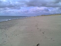
Popular Beaches are located at Courtown, Curracloe, and Duncannon.
Some other places of interest include:
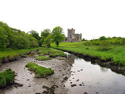
|
| Tintern Abbey | Ballyteigue Bay |
 |
 |
Famous natives
|
|
Famous residents
- Michael Balfe - musician, grew up in Wexford
- Des Bishop - American-Irish Comedian.
- Chris de Burgh (born Christopher John Davison) - Singer-songwriter and musician.
- Dermot Desmond - Entrepreneur.
- Anna Maria Hall (Mrs. S.C. Hall) - Author.
- Thomas D'Arcy McGee - Author, journalist and historian.
- John Redmond - Politician.
References & footnotes
- ↑ 1.0 1.1 "FAQ - Area by County in Land and Water (Fresh)". Ordnance Survey Ireland (OSi) Website. Retrieved on 2008-05-19.
- ↑ Census 2006 — Volume 1 - Population Classified by Area (Dublin: Stationery Office, 27 April 2007)PDF (4.22 MB) – Central Statistics Office (Ireland). Retrieved on 2008-05-16.
- ↑ Furlong, p. 22.
- ↑ Colfer, p. 21.
- ↑ Furlong, p. 18.
- ↑ Byrne, Irish Kings and High Kings, pp 130 - 164.
- ↑ 7.0 7.1 Stout, Geraldine. "Essay 1: Wexford in Prehistory 5000 B.C. to 300 AD" in Wexford: History and Society, pp 1 - 39.
- ↑ "Ballybrittas Portal Tomb (with Photo) - well preserved". Megalithomania.com. Retrieved on 2008-05-16.
- ↑ "Newbawn Portal Tomb (with Photo) – badly dilapidated". Megalithomania.com. Retrieved on 2008-05-16.
- ↑ 10.0 10.1 Annals of the Four Masters (A.F.M.)
- ↑ Furlong and Hayes, pp 46 - 70.
- ↑ Furlong, p. 143.
- ↑ "Bombing of Campile remembered". Wexford People (1 September 2000). Retrieved on 2008-05-21.
- ↑ South East Radio's Website.
- ↑ Census 2006, Volume 1, p. 19.
- ↑ Census 2006, Volume 2 - Ages and Marital Status, pp 18-19.
- ↑ Census 2006, Volume 13 - Religion, p.27.
- ↑ Census 2006, Volume 1, p. 13.
- ↑ 2006 Census
- ↑ Rosslare MET Station.
- ↑ 21.0 21.1 "Climate - 30 Year Averages – Rosslare MET Station - monthly and annual mean and extreme values (1961-1990)". MET ÉIREANN Website. Retrieved on 2008-05-14.
- ↑ "Climate - Wind". MET ÉIREANN Website. Retrieved on 2008-05-15.
- ↑ "Climate - Rainfall – & Map (Mean Annual Rainfall (mm) 1961-90)". MET ÉIREANN Website. Retrieved on 2008-05-15.
- ↑ The Times Atlas of the World, p. 107 (Map - Ireland).
- ↑ 25.0 25.1 25.2 25.3 OSI, Discovery Series 77.
- ↑ "FAQ - Longest Rivers in Ireland". Ordnance Survey Ireland (OSi) Website. Retrieved on 2008-05-19.
- ↑ Rosslare Golf Club (18 holes).
- ↑ Enniscorthy Golf Club (18 holes).
- ↑ Courtown Golf Club website.
- ↑ New Ross Golf Club - 18 holes.
- ↑ Scarke Golf Course & Driving Range website.
- ↑ Blackwater Par 3 Golf Course website.
- ↑ "Wexford Racecourse". Retrieved on 2008-05-10.
- ↑ "Enniscorthy Greyhound Track". Irish Greyhound Board website. Retrieved on 2008-05-10.
- ↑ "Remembering Carnsore crusade", Wexford People (12 September 2001). Retrieved on 2008-05-19.
- ↑ "Great Island generating station". ESB Website. Retrieved on 2008-05-10.
- ↑ "No more smoke from chimneys". New Ross Standard (Wednesday, 30 April 2008). Retrieved on 2008-05-10.
- ↑ "Endesa buy Great Island but staff talks continue". New Ross Standard (Wednesday, 6 August 2008). Retrieved on 2008-08-14.
- ↑ 39.0 39.1 39.2 39.3 "Geology Matters, Issue No.5, Autumn 2006 - A Geological Synopsis of Co. Wexford". Geological Survey of Ireland (GSI) website. Retrieved on 2008-05-21.
- ↑ Gardiner, M.J. & Pierce Ryan. Soils of Co. Wexford. Dublin: An Foras Talúntais, 1964.
- ↑ "Irish firm reports 'significant' oil find off Hook Head", Irish Independent (10 October 2007). Retrieved on 2008-05-10.
- ↑ [1] [2]
- ↑ Herbert F. Hore (ed.), "A Chorographic Account of the Southern part of the County of Wexford, written Anno 1684, by Robert Leigh. Esq., of Rosegarland, in that County" in "The Journal of the Kilkenny and South-East of Ireland Achaeological Society" (Dublin, 1859), p. 467.
- ↑ See William Thompson, "The Natural History of Ireland", Vol. 1 - (London, 1849), p. 328, for further details - other historical accounts mentioned here confirm Leigh's statement.
- ↑ Wexford Opera Website.
- ↑ "Count of Monte Cristo comes to Duncannon", Wexford People (28 August 2008). Retrieved on 2008-07-18.
- ↑ "Branch Libraries (Co. Wexford)". Wexford County Council Website. Retrieved on 2008-05-18.
- ↑ "General Hospitals - Services Map". South Eastern Health Board Website. Retrieved on 2008-05-11.
- ↑ "Psychiatric Hospitals - Services Map". South Eastern Health Board Website. Retrieved on 2008-05-11.
- ↑ "Ferns Castle". Heritage Ireland website. Retrieved on 2008-05-15.
- ↑ "National 1798 Visitor Centre". National 1798 Visitor Centre Website. Retrieved on 2008-05-15.
- ↑ "Dunbrody Abbey". Dunbrody Abbey Visitors Centre Website. Retrieved on 2008-05-16.
Bibliography
- Byrne, Francis J. Irish Kings and High Kings. Dublin, 1973-2001.
- Carlyle, Thomas. "Oliver Cromwell's Letters and Speeches". Vol. 1. New York: Wiley & Putnam, 1845.
- Cambrensis, Giraldus. Expugnatio Hibernica - The Conquest of Ireland. Dublin: R.I.A., 1978.
- Colfer, Billy. The County of Wexford. Co. Wexford: Foillsitheoirí Cois Sláine, n.d. - 1980 or 1981.
- Furlong, Nicholas. A History of County Wexford. Dublin: Gill & MacMillan, 2003. ISBN 0 7171 3461 X.
- Furlong, Nicholas and John Hayes. County Wexford in the Rare Oul' Times. Vol. IV. 1910-1924. Wexford: Old Distillery Press, 2005. ISBN 0 9512812 3 2.
- Ordnance Survey Ireland (OSi). Discovery Series 77 - Co Wexford (part). Scale 1: 50,000. Dublin: OSI, Phoenix Park, 1997. ISBN 0-904996-71-9.
- The Times Atlas of the World – Reference Edition. London: Times Books, 1995-2002. ISBN 0 00 712400 7.
- Whelan, K.(ed) & W. Nolan (assoc. ed.). Wexford: History and Society. Dublin: Geography Publications, 1987.
See also
- List of towns and villages in Ireland
- List of abbeys and priories in Ireland (County Wexford)
External links
|
||||||||||||||||||||
