County Dublin
County Dublin (Irish: Contae Bhaile Átha Cliath), or more correctly today the Dublin Region[1] (Réigiúin Átha Cliath), is the area that contains the city of Dublin, the capital and largest city of the state of Ireland as well as the largest city on the island of Ireland; and the modern counties of Dun Laoghaire-Rathdown, Fingal and South Dublin. The Dublin Regional Authority is the regional authority for the region. Dublin was one of the oldest of the Counties of Ireland to be formally structured.
Introduction
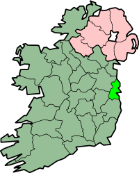
Dublin is located on the east coast of Ireland in the province of Leinster. The area held county status until its dissolution as such in 1994, where Section 9 Part 1(a) of the Local Government (Dublin) Act, 1993 stated that as of 1 January 1994 "the county shall cease to exist".[2] At that time, and in response to a European Council report highlighting Ireland as the most centralised country in the European Union, it was decided that a single County Dublin was unmanageable and undemocratic from a local government perspective. The county was formally abolished and replaced with Dun Laoghaire-Rathdown, Fingal, and South Dublin. The Government was fully aware of the magnitude of the legislation that was being passed, most poignantly noted by Avril Doyle, TD in Dáil Éireann on 3 November 1993, where she declared "The Bill before us today effectively abolishes County Dublin. I am not sure whether Dubliners realise that that is what we are about today, but in effect that is the case".[3]
Current status
At present, many organisations, state agencies and sporting teams continue to operate on a "County Dublin" basis. Subsequently, much confusion exists around the legitimacy of the new counties - though they do have administrative county status, the only protected recognition of a county within the Republic of Ireland. County Dublin is now defined in legislation solely as the "Dublin Region" under the Local Government Act, 1991 (Regional Authorities) (Establishment) Order, 1993,[1] and this is the terminology officially used by the four Dublin administrative councils in press releases concerning the former county area. Separate use of the term Greater Dublin Area, which consists of all of the Dublin Region and the counties of Kildare, Meath and Wicklow has created additional confusion. The census of 2002[4] recorded the total population of the Dublin Region at 1,122,821, accounting for 28% of the national figure.
The latest Ordnance Survey Ireland "Discovery Series" (Third Edition 2005) 1:50,000 map of the Dublin Region, Sheet 50, shows the boundaries of the city and three surrounding counties of the region. Extremities of the Dublin Region, in the north and south of the region, appear in other sheets of the series, 43 and 56 respectively.
Local government
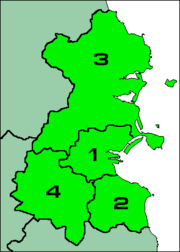
Map of the Dublin Region
Dublin City Council has existed for centuries, previously as Dublin Corporation, as a county borough, whilst Dublin County Council in 1994 was abolished and replaced by three new county councils. Thus in summary the local authority divisions within the Dublin Region are:
| Name |
Map |
Area |
Pop: 2006[4] |
| km² |
sq mi |
| City of Dublin |
1 |
114.99 km2 |
44.40 sq mi (12.6%) |
505,739 (42.6%) |
| County of Dun Laoghaire-Rathdown |
2 |
127.31 km2 |
49.15 sq mi (13.9%) |
193,688 (16.3%) |
| County of Fingal |
3 |
448.07 km2 |
173.00 sq mi (49.1%) |
239,813 (20.2%) |
| County of South Dublin |
4 |
222.74 km2 |
86.00 sq mi (24.4%) |
246,919 (20.8%) |
Towns and suburbs
- Adamstown, Artane, Ashington, Ashtown
- Balbriggan, Baldoyle, Balgriffin, Ballinteer, Ballsbridge, Ballybrack, Ballycullen, Ballyfermot, Ballymun, Balrothery, Bayside, Beaumont, Belfield, Blackrock, Blanchardstown, Bluebell , Booterstown, Brittas
- Cabinteely, Cabra, Carpenterstown, Carrickmines, Castleknock, Chapelizod, Cherrywood, Churchtown, Citywest, Clondalkin, Clonshaugh, Clonsilla, Clonskeagh, Clontarf, Coolmine, Coolock, Crumlin
- Dalkey, Darndale, Dartry, Deansgrange, Dollymount, Dolphin's Barn, Donabate, Donaghmede, Donnybrook, Donnycarney, Drimnagh, Drumcondra, Dún Laoghaire, Dundrum
- East Wall, Edmondstown
- Fairview, Finglas, Firhouse, Foxrock
- Galloping Green, Glasnevin, Glasthule, Glencullen, Glenageary, Goatstown, Grangegorman
- Harolds Cross, Hartstown, Howth, Huntstown
- Inchicore, Irishtown, Islandbridge
- Jobstown
- Kill O' The Grange, Kilbarrack, Killester, Killiney, Kilmacud, Kilmainham, Kilmore, Kilnamanagh, Kilsallaghan, Kilternan, Kimmage, Kinsealy, Knocklyon
- Leopardstown, Loughlinstown, Lucan, Lusk
- Malahide, Marino, Merrion, Milltown, Monkstown, Mount Merrion, Mulhuddart
- Newcastle, Naul
- Oldbawn, Ongar
- Palmerstown, Perrystown, Phibsborough, Portmarnock, Portobello
- Raheny, Ranelagh, Rathcoole, Rathfarnham, Rathgar, Rathmichael, Rathmines, Rialto, Ringsend, Rush
- Saggart, Sallynoggin, Sandycove, Sandyford, Sandymount, Santry, Shankill, Skerries, Smithfield, Stepaside, Stillorgan, Stoneybatter, Strawberry Beds, Sutton, Swords
- Tallaght, Templeogue, Terenure, The Coombe, Tyrrelstown
- Walkinstown, Whitechurch, Whitehall, Windy Arbour
See also
- List of abbeys and priories in the Republic of Ireland (County Dublin)
- List of subdivisions of County Dublin
References
External links
|
Divisions of the former County Dublin, Ireland |
|
| County seats: Dublin · Dún Laoghaire · Tallaght · Swords |
|
| Cities |
|
|
|
| Counties |
Dun Laoghaire-Rathdown · Fingal · South Dublin
|
|
| Districts |
Northside · Southside
|
|
| See also |
Dublin Metropolitan Area · Greater Dublin Area
|
|